- Montgomery Place, Saskatoon
-
Montgomery Place — Neighborhood — Country  Canada
Province  Saskatchewan
City Saskatoon Suburban Development Area Confederation Suburban Development Area Neighbourhood Montgomery Place Annexed Construction Government – Type Municipal (Ward 2) – Administrative body Saskatoon City Council – Councillor Pat Lorje Area – Total 1.7 km2 (0.7 sq mi) Population (2006) – Total 2,557 – Average Income $$70,734 Time zone UTC (UTC-6) Website Montgomery Place City of Saskatoon Neighborhoods Montgomery Place, is a post World War II community erected for veterans outside of the city of Saskatoon, Saskatchewan, which consists primarily of residential homes.[1][2] It was amalgamated within the city of Saskatoon in 1956.[3] Montgomery Place has an average household size of 3 persons, and homeownership isat 87.5%. In 2006, the average home selling price was $198,582.[4]
Contents
History
 Lower speed limit around schools. Montgomery School, Montgomery Place, Saskatoon
Most of this neighbourhood was built after World War II as a part of the Veterans' Land Act settlement plan. 10 years later in 1955 it became a neighborhood of Saskatoon[5][6][7]
This monument commemorates the Canadian Forces veterans who built their homes here during the years 1946-77. Montgomery Place was established with small land holdings under the Federal Government;s Veteran's Land Act for men and women returning from World War II and the Korean War. Dedicated September 16, 1999
— Image Origins of Montgomery Place
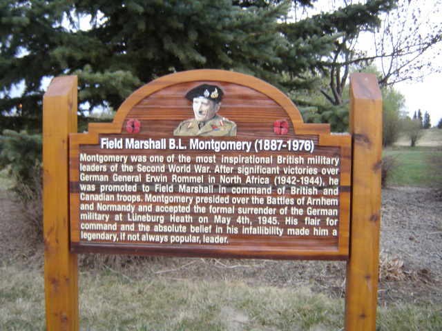
Field Marshal B.L. Montgomery (1887-1976) Montgomery was one of the most inspirational British military leaders of the Second World War. After significant victories over German General Erwin Rommel in North Africa (1942-1944), he was promoted to Field Marshal in command of British and Canadian troops. Montgomery presided over the Battles of Arnhem and Normandy and accepted the formal surrender of the German military at Luneburg Heath on May 4, 1945. His flair for command and the absolute belief in his infallibility made him a legendary, if not always popular, leader.
— Image B.L. Montgomery
Lt. Colonel Cecil Merritt (1908-1991) Lt. Col. Cecil Merritt won the first Victoria Cross given to a Canadian in WWII for gallantry and inspired leaderhip during the disastrous raid in Dieppe. He landed with the South Saskatchewan Regiment at Pourville on August 19, 1942. To capture important high ground to the east, they had to cross the Scie by a bridge under heavy fire. Seeing the situations, Merritt walked on to the bridge, waved his helmet to encourage his men, and shouted: "Come on over, there's nothing to worry about here." After hours of heavy fighting, Merritt and his men were taken captive. Merritt was commended for his leadership while a prisoner.
— Image Cecil Merritt
Future expansion
The current neighbourhood saw final build-out in the early 1980s. Current (2008) development plans for the region call for an expansion of Montgomery Place to the west of Chappell Drive, with additional residential development (previously, the area had been earmarked for a light industrial district), as well as residential development to the north of 11th Street and east of the grain terminal. A new law has been put into place in this community that you can no longer sub-divide lots. The community wants to keep large spacious yards a tradition for many years to come.[8]
Layout
 Origins of Montgomery Place, Saskatoon
11th Street is the northernmost road in Montgomery. Chappell Drive is the furthest west road at present, whereas Dundonald Avenue is the easternmost. The southern boundary of the community's residential development is denoted by Burma Road, a private (non-City of Saskatoon) roadway servicing the CN Rail yards on the south side of Montgomery Place. The neighborhood is a conglomeration of streets and avenues in near grid fashion combined with courts. The neighbourhood naming practices honour the history and theaters of World War II.[9][10]
The city's main rail yard and passenger station is located on the south side of Montgomery Place, and the northern side of the community is in the shadow of the former AgPro Grain Terminal, one of the city's iconic landmarks.
Streets
 Newer area of Montgomery Place, Saskatoon
The following streets are located in this area:
11th Street West, Caen Street, Arnhem Street, Normandy Street, Ortona Street, Merritt Street, Dieppe Street, Mountbatten Street, McNaughton Avenue, Elevator Road, Rockingham Avenue, Haida Avenue, Simonds Avenue, Cassino Avenue & Place, Crerar Drive, Crescent Boulevard, Lancaster Boulevard & Crescent, Bader Crescent, Dundonald Avenue, Chappell Drive.
In addition, Burma Road, a private roadway, runs east-to-west between the residential development of Montgomery Place and the rail yards to the south. The road does not appear on official city maps, but is recognized by Google Maps, and street signs have been erected.
Government and politics
Montgomery Place exists within the federal electoral district of Saskatoon--Rosetown--Biggar. It is currently represented by Kelly Block of the Conservative Party of Canada.[11]
Provincially, the area is within the constituency of Saskatoon Riversdale. It is currently represented by Danielle Chartier of the Saskatchewan New Democratic Party.[12][13]
In Saskatoon's non-partisan municipal politics, Montgomery Place lies within ward 2. It is currently represented by Pat Lorjet, first elected in 2003 and re-elected in 2006.[14] Montgomery Place dropped 10 per cent below the average, causing a look at getting the city wards remapped.[15] Pat Lorje stated that she feels inner - city residents may have been undercounted during the last census.
Education
- Montgomery School Public Elementary School
- St. Dominic Separate Elementary School
Shopping
 B.L. Montgomery, Namesake. Montgomery Place, Saskatoon
The Confederation Suburban Center is the closest large retail center and contains 400 operating businesses which is 8% of Saskatoon's retail sector. The Blairmore suburban Center is under construction.
In addition Montgomery Place is home to Greg's Grocery Plus, a local bakery and convenience store. The neighbourhood was once home to the Montgomery Grocery, at the corner of Dundonald Ave. and 11th Street; the building has been demolished as the intersection prepares for eventual construction of the southwest leg of Circle Drive.
See also
List of shopping malls in Saskatoon
 Cecil Merritt. Montgomery Place, Saskatoon this plaque can be found at the corner of Merritt Street and Rockingham Avenue
Community Events
The annual Montgomery Garage Sale occurs on the first Saturday in May. By all measures, this is the largest community garage sale in Saskatoon. Many community groups use the event as an opportunity to host fundraising barbecues and bake sales. If you plan to attend, it is advisable to avoid driving as the neighbourhood becomes terribly congested on the day of the event.
In addition, Montgomery Place hosts its very own Remembrance Day ceremony each year in Montgomery Park. Given its unique history as a veteran's neighbourhood (as reflected by many of the street names), there is always overwhelming community support for the service.[16][17][18]
Area Parks
- Gougeon Park 2.26 acres (9,100 m2)
- Lt. Col. Drayton Walker Park 1.93 acres (7,800 m2)
- Lt. Gen. G.G. Simonds Park 2.76 acres (11,200 m2)
- Montgomery Park 8.32 acres (33,700 m2)
Other recreation
- The CN Curling Club is located on Chappell Drive on the west side of the community.
Transportation
City Transit
Location
Coordinates: 52°6'37"N 106°43'51"W Coordinates: 53°16′37″N 106°43′51″W / 53.276944°N 106.730833°W
North: AgPro Industrial
FairhavenWest: CN yards Management Area Chappell Drive Montgomery Place East: South West Industrial South: Saskatoon railway station
C.N. Yards Management AreaReferences
- ^ Memorial Cairn Dedication Service URL accessed March 18, 2007
- ^ Newspaper Articles URL accessed March 18, 2007
- ^ [History of Saskatoon#Post War Years|History of Saskatoon] URL accessed April 1, 2007
- ^ Neighborhood Profiles
- ^ 50th Anniverary Celebration URL accessed March 18, 2007
- ^ Montgomery Park 1955 URL accessed March 18, 2007
- ^ Saskatoon History Review Montgomery URL accessed March 18, 2007
- ^ City of Saskatoon, Projected Growh Map, October 10, 2008 (accessed November 16, 2008)
- ^ Trinity Church URL accessed March 18, 2007
- ^ Pictures of CN URL accessed March 18, 2007
- ^ "Voter Information Service -". Elections Canada. http://www.elections.ca/scripts/pss/InfovoteMain_ne.aspx?L=e&ED=47011&EV=99&EV_TYPE=6&PC=S7K6N9&Prov=&ProvID=&MapID=&QID=-1&PageID=21&TPageID=. Retrieved 2008-08-261.
- ^ "Provincial Constituency Boundaries: City of Saskatoon". Elections Saskatchewan. http://www.elections.sk.ca/constituency.php?cID=48&page=mla-1&PageID=21&TPageID=. Retrieved 2008-08-261.
- ^ "CTI". http://www.textiles.ca/eng/IssPolContacts/7601.cfm. Retrieved 2008-08-261.
- ^ "City of Saskatoon · City Council · Ward Councillors · Ward 2 - Councillor Pat Lorje". http://www.briarwoodca.com/. Retrieved 2008-08-261.
- ^ Nickel, Rod (August 26, 2008). "City wards being remapped East-side neighborhoods show population growth". The StarPhoenix: pp. Front Page. http://www.canada.com/saskatoonstarphoenix/
- ^ History of the Marshall Building/Mitchells URL accessed March 18, 2007
- ^ Memories of Montgomery Place by Margaret Gent 1996 URL accessed March 18, 2007
- ^ City of Saskatoon · Departments · Community Services · Community ... URL accessed March 18, 2007
- ^ Selling an Idea or a Product URL accessed January 27, 2007
External links
- City of Saskatoon · Departments · Community Services · City Planning · ZAM Maps
- Populace Spring 2006
Categories:- Neighbourhoods in Saskatoon


Wikimedia Foundation. 2010.