- Interstate 90 in New York
-
This article is about the section of Interstate 90 in New York. For the entire length of the highway, see Interstate 90.
Interstate 90

Map of New York with I-90 highlighted in redRoute information Maintained by NYSTA and NYSDOT Length: 385.88 mi[2] (621.01 km) Existed: August 14, 1957[1] – present Major junctions West end:  I-90 in Erie, PA
 US 219 in West Seneca
 I-190 near Buffalo
 I-390 near Rochester
 I-81 near Syracuse
 NY 12 in Utica
 I-88 in Schenectady
 I-87 in Albany
East end: I-90 in West Stockbridge, MAHighway system Main route of the Interstate Highway System
Main • Auxiliary • BusinessNumbered highways in New York
Interstate • U.S. • N.Y. (former) • Reference • County←  NY 89
NY 89NY 90  →
→Interstate 90 (I-90) is a part of the Interstate Highway System that runs from Seattle, Washington, to Boston, Massachusetts. In the U.S. state of New York, I-90 extends 385.88 miles (621.01 km) from the Pennsylvania state line at Ripley to the Massachusetts state line at Canaan. Although most of the route is part of the New York State Thruway, a non-tolled section (situated in the Capital District and not part of the Thruway system) links Albany and its eastern suburbs. Within New York, I-90 has a complete set of auxiliary Interstates. For most of its length in New York, I-90 runs parallel to the former Erie Canal route, New York State Route 5 (NY 5), U.S. Route 20 (US 20) and the CSX railroad mainline that traverses the state.
I-90 was assigned in 1957 as part of the establishment of the Interstate Highway System. In New York, it was overlaid on the pre-existing New York State Thruway from Pennsylvania to Albany, from where it would have continued to Massachusetts on a new freeway that bypassed the Berkshire Connector to the north. Ultimately, the freeway was built from the Thruway mainline in Albany to the Berkshire Connector in Schodack, and I-90 was assigned to the segment of the Connector east of the proposed freeway. The Albany–Schodack freeway was completed in stages during the 1960s and 1970s and fully open by 1977.
Contents
Route description
New York State Thruway
Main article: New York State Thruway (mainline)West of Albany, I-90 in New York is designated along the mainline of the New York State Thruway. The Thruway begins at the Pennsylvania state line in Chautauqua County, following the shore of Lake Erie northeast and passes through the town of Cheektowaga, a large suburb of Buffalo directly east of the city. Two auxiliary routes, I-190 (leading to Niagara Falls) and I-290 (a northerly bypass of Buffalo) connect with I-90 here. East of Erie County, the Thruway turns east and passes through the suburbs of several major cities in Upstate New York, generally following the path of the Erie Canal. It passes south of Rochester and north of Syracuse, which are served by three auxiliary Interstate Highways: I-490 and I-390 connect to Rochester, while I-690 leads to Syracuse.[3]
 Approaching exit 54 on I-90 westbound in West Seneca
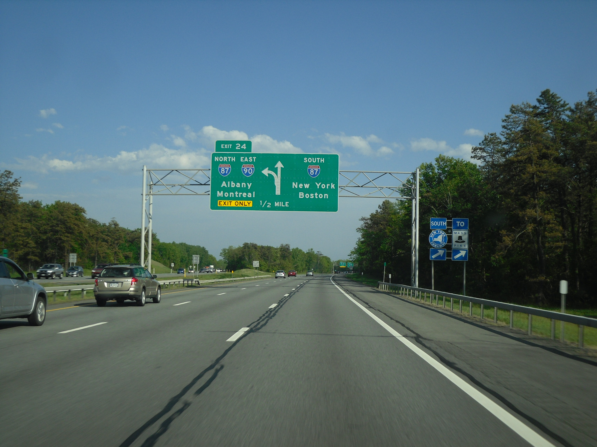
East of Syracuse, the Thruway follows the Erie Canal and, later, the Mohawk River into the Mohawk Valley toward Utica, where I-90 skirts the northern edge of downtown and meets I-790, a short route leading into the city's center. Farther east, the freeway indirectly serves the canal and riverside cities of Little Falls (via NY 169) and Amsterdam (NY 30) on its way to Schenectady, where I-890 splits from the Thruway and serves as the connection to the city center. It rejoins I-90 in Albany County, where I-90 leaves the mainline of the Thruway at exit 24 in Albany, which is signed for I-87 north and I-90 east. Here, the route designation of the Thruway changes from I-90 east to I-87 south. Traffic intending to continue on I-90 or reach I-87 north must exit the Thruway here. Exit numbers and mile markers for I-90 reset after exiting.[3]
Albany and Rensselaer counties
The Albany–Schodack section of I-90—the only portion of I-90 in New York that is not part of the Thruway system—begins concurrent with I-87 and heads southeast from Thruway exit 24 to a toll barrier that, for now, marks the end of tolls along the freeway. Now a toll-free highway, I-90 and I-87 continue to exits 1N and 1S, which are for the Adirondack Northway (I-87) and Fuller Road Alternate (unsigned NY 910F), respectively. Located off exit 1S and Fuller Road Alternate, a spur of the Northway leading to Western Avenue (US 20), is the Crossgates Mall in Guilderland. I-90 proceeds eastward, meeting Washington Avenue at an interchange connecting to UAlbany, a state college, eastbound and Fuller Road (County Route 156 or CR 156) westbound.[4]
Exits 3 and 4, located 0.6 miles (1.0 km) apart in an area bounded by Washington and Central (NY 5) Avenues, lead to the W. Averell Harriman State Office Building Campus and the New York State Police Academy (exit 3) and to the Crosstown Arterial (NY 85 at exit 4). I-90 subsequently crosses over NY 5 and passes north of Westgate Plaza as it connects to Everett Road (CR 155). The freeway continues along the northern edge of Albany to exit 5A,[4] a large trumpet interchange originally built to serve I-687.[5] After that project was cancelled, it was repurposed as an exit for Corporate Woods Boulevard. East of exit 5A, I-90 passes by slightly more residential areas ahead of a stack interchange with US 9 1 mile (1.6 km) north of downtown Albany. Albany Memorial Hospital is located just north of the exit on US 9.[4]
 The stack interchange between I-90 and US 9 in Albany as seen from I-90 eastbound
Not far to the east of US 9 is a second stack interchange, connecting I-90 to I-787 in the industrial northeasternmost section of the city of Albany. At this point, I-90 turns to the southeast and follows the Patroon Island Bridge over the Hudson River and into Rensselaer County. Across the river, I-90 becomes the Rensselaer County Veterans Memorial Highway and passes through much less developed areas. In its first 1.5 miles (2.4 km) in the county, the freeway meets Washington Avenue at the northern edge of the city of Rensselaer and the west end of NY 43 in the town of North Greenbush, southwest of US 4 and Defreestville. South of NY 43, I-90 and US 4 follow parallel routings into East Greenbush, where I-90 directly connects to US 4 at exit 11.[4]
I-90 heads southeastward across an undeveloped, forested section of the county, crossing over NY 151 and entering the town of Schodack, where it meets Miller Road, a connector between I-90 and the concurrent routes of US 9 and US 20. The freeway and the overlapping U.S. Routes follow similar routings to Schodack Center, at which point I-90 finally connects to US 9 and US 20 at exits 11E and 11W. I-90 heads due south from this point, passing over NY 150 and paralleling US 9, which splits from US 20 at Schodack Center. The routes cross paths again at exit 12 just north of where I-90 rejoins the Thruway system at a toll barrier preceding exit B1 of the Berkshire Connector.[4]
Berkshire Connector
Main article: New York State Thruway (Berkshire Connector)I-90 heads southeast on the Connector, meeting the north end of the Taconic State Parkway in the Columbia County town of Chatham at exit B2 and NY 22 at exit B3 in the town of Canaan 1 mile (1.6 km) from the Massachusetts state line. The Berkshire Connector ends at the state line; however, I-90 continues southeast into Massachusetts as the Massachusetts Turnpike.[3]
History
Main article: New York State Thruway The Berkshire Connector (I-90) near exit B2 in Chatham
The east–west corridor I-90 follows across New York has always been major, followed by the Genesee Trail (1790s), Erie Canal (1825), New York Central Railroad (1853), and later the Yellowstone Trail (1912), which became US 20 and NY 5. It was planned as part of a nationwide toll road system as early as 1938.[6] Exactly which cities would be served changed over the years, but it was the state of New York that made the decision in 1942, when they passed a law for the construction of a New York City – Albany – Buffalo – Pennsylvania "thruway". This highway, passing Utica, Syracuse, and Rochester on its path between Albany and Buffalo, would provide construction jobs in the post-World War II period.[7] The Berkshire Thruway, a branch east from near Albany to Massachusetts, was authorized in 1944, completing the east–west route across the state.[8] However, construction, which began in 1946, proceeded very slowly, with only one four-mile (6 km) portion open by 1950, when a law created the New York State Thruway Authority (NYSTA) to operate the route as a toll road. Construction then progressed much more rapidly, especially after 1954, when the authority was allowed to issue bonds not backed by the state (thus having higher interest rates).[9] The roadway was completed between Buffalo and Albany in 1954,[10] to New York City in 1956,[11] to Pennsylvania in 1957,[12] and to Massachusetts in 1959.[13]
In the meantime, the National Interstate and Defense Highways Act was enacted in 1956, promising a toll-free network of Interstate Highways throughout the nation. The Bureau of Public Roads (BPR) commissioner soon announced that the toll road met all federal Interstate Highway standards,[14] and on August 14, 1957, most of the mainline of the Thruway was incorporated into the system as part of Interstates 87 and 90. Most of the connecting Massachusetts Turnpike was also included, but a more northerly alignment, avoiding the Berkshire Thruway, was proposed by the states of New York and Massachusetts for I-90 through Albany past Pittsfield to East Lee, Massachusetts.[1][15] This alignment would be about 30% shorter than the all-toll alignment, and would provide relief to the four-lane Castleton Bridge on the Berkshire Thruway, which had been built narrower than the rest of the system because of the planned parallel alternate.[16] The BPR objected to the duplication, which would cost over $90 million, and refused to approve this alignment.[17] The eventual route ran southeast from Albany to the Berkshire Thruway at the Nassau interchange, providing Albany with an alternate route and additional bridge, but not offering any savings in distance, and creating a "toll trap" for drivers accessing the Taconic State Parkway from Albany.[18]
 Overhead signage for exit 24 in Albany, where I-90 leaves the Thruway mainline to serve downtown Albany.
Construction on the route of I-90 through Albany began ca. 1963, with both ends at existing Thruway interchanges: exit 24, which crossed the Adirondack Northway (I-87) at a cloverleaf interchange and connected to Washington Avenue in western Albany, and exit B1, which connected to US 9 near Nassau.[19][20] Work on the freeway began at the Northway and progressed southeasterly to the Berkshire Connector in Rensselaer County. The portion between the Northway and Everett Road was opened to traffic in the mid-1960s[21][22] while the piece extending from Everett Road to US 4 east of Rensselaer was completed in the early 1970s.[23][24] The last section of the highway was completed to US 9 and US 20 in Schodack Center ca. 1974[25][26] and finished by 1977.[27] The Northway cloverleaf was rebuilt in the late 1980s.[28][29]
In 1999, the New York State Department of Transportation, the Federal Highway Administration and NYSTA discussed redesignating the Berkshire Connector as I-90 and redesignating the non-toll part of I-90 from Thruway exit 24 to exit B1 on the Connector as I-88. The section of the Thruway between exits 25 and 24 would then be co-designated as both I-90 and I-88. This was never implemented.[30]
Exit list (non-Thruway part of I-90 in New York)
County Location Mile[2] Exit Destinations Notes Albany Albany 0.00 25-61-23-1  I-87 south / Thruway south – New York, Boston
East end of Thruway (mainline) overlap; west end of I-87 overlap 0.25 1S  To US 20 (Western Avenue)
0.40 1N I-87 north – Albany International Airport, MontrealEast end of I-87 overlap 1.10 2 Washington Avenue / Fuller Road – UAlbany 2.04 3 State Offices 2.36 4  NY 85 – Slingerlands, Voorheesville
Eastern terminus of NY 85 3.38 5 Everett Road 4.00 5A Corporate Woods Boulevard Formerly planned for I-687 5.51 6  US 9 – Arbor Hill, Loudonville
6.36 6A  I-787 – Albany, Troy
Rensselaer Rensselaer 7.15 7 Washington Avenue – Rensselaer Eastbound exit and westbound entrance North Greenbush 7.95 8  NY 43 – Defreestville
Western terminus of NY 43 East Greenbush 9.68 9  US 4 – East Greenbush, Rensselaer, Troy
Schodack 13.32 10 Miller Road – Schodack Center, East Greenbush 14.74 11 US 9 / US 20 – East Greenbush, NassauSigned as exits 11W (north/west) and 11E (south/east) eastbound 19.80 12 US 9 – Hudson20.18 Thruway west to I-87 – New York City, BuffaloWest end of Thruway (Berkshire Connector) overlap 1.000 mi = 1.609 km; 1.000 km = 0.621 mi See also
References
- ^ a b American Association of State Highway Officials (August 14, 1957). Official route numbering for the National System of Interstate and Defense Highways (Map).
- ^ a b "2008 Traffic Volume Report for New York State" (PDF). New York State Department of Transportation. June 16, 2009. pp. 146–149. https://www.nysdot.gov/divisions/engineering/technical-services/hds-respository/NYSDOT%20TVR%202008%20by%20Route.pdf. Retrieved January 31, 2010.
- ^ a b c I Love New York (2009). New York State Map (Map). Cartography by Map Works.
- ^ a b c d e Yahoo! Inc. Yahoo! Maps – overview map of Interstate 90 from Albany to Berkshire Thruway (Map). Cartography by NAVTEQ. http://maps.yahoo.com/#mvt=h&lat=42.59352&lon=-73.764625&zoom=12&q1=42.707209%2C-73.858937&q2=42.481194%2C-73.672427. Retrieved November 18, 2010.
- ^ "History". Adirondack Northway Exit 3 Project. New York State Department of Transportation. https://www.nysdot.gov/regional-offices/region1/projects/i87exit3/history. Retrieved June 11, 2010.
- ^ Bureau of Public Roads (1938). Location of Routes Selected for Study (Map).
- ^ Statement by Assemblyman Moffat and Senator Hampton Relative to the Establishment of a State Thruway System, March 13, 1942, New York Legislative Document, 1942, v. 15 no. 80–82, p. 153
- ^ "The New York State Thruway: The Beginning". Thruway Chronology. New York State Thruway Authority. 2002. http://www.upstatenyroads.com/thruway-history1.shtml. Retrieved November 18, 2010.
- ^ Kaszynski, William (2000). The American Highway: The History and Culture of Roads in the United States. McFarland & Company. pp. 141–142. ISBN 0-7864-0822-7.
- ^ Weaver, Warren Jr. (October 27, 1954). "More of Thruway Opened by Dewey". The New York Times: p. 31.
- ^ Ingraham, Joseph C. (August 27, 1956). "Thruway Opening Final Link Friday". The New York Times: p. 21.
- ^ "The Thruway Becomes the Longest Toll Road". The New York Times: p. 159. December 15, 1957.
- ^ Ingraham, Joseph C. (May 24, 1959). "Boston to Chicago". The New York Times: p. XX1.
- ^ Pierce, Bret (September 19, 1956). "Thruway Called a Model Project". The New York Times: p. 39.
- ^ Traffic Engineering (Institute of Traffic Engineers) 28. 1957.
- ^ Highway Cost Estimates: Hearings before a Subcommittee of the Committee on Public Works, 1958, p. 173
- ^ U.S. Congress, Miscellaneous Highway Legislation, 1961, p. 112
- ^ "Rockefeller Urged to Veto Road Link". The New York Times: p. 25. March 30, 1964.
- ^ Esso (1962). New York with Sight-Seeing Guide (Map). Cartography by General Drafting (1962 ed.).
- ^ Esso (1963). New York Happy Motoring Guide (Map). Cartography by General Drafting (1963 ed.).
- ^ Mobil (1965). New York (Map). Cartography by Rand McNally and Company.
- ^ Esso (1968). New York (Map). Cartography by General Drafting (1969–70 ed.).
- ^ State of New York Department of Commerce (1969). New York State Highways (Map). Cartography by Rand McNally and Company.
- ^ Gulf Oil Company (1972). New York and New Jersey Tourgide Map (Map). Cartography by Rand McNally and Company (1972 ed.).
- ^ Shell Oil Company (1973). New York (Map). Cartography by H.M. Gousha Company (1973 ed.).
- ^ Gulf Oil Company (1974). New York and New Jersey Tourgide Map (Map). Cartography by Rand McNally and Company.
- ^ Exxon (1977). New York (Map). Cartography by General Drafting (1977–78 ed.).
- ^ Federal Highway Administration (2009). "Structure 1073530". National Bridge Inventory. United States Department of Transportation. http://nationalbridges.com/nbi_record.php?StateCode=36&struct=000000001073530. Retrieved November 18, 2010.
- ^ Federal Highway Administration (2009). "Structure 1073540". National Bridge Inventory. United States Department of Transportation. http://nationalbridges.com/nbi_record.php?StateCode=36&struct=000000001073540. Retrieved November 18, 2010.
- ^ Bergman Assocatiates (February 13, 2008). "Hudson River Crossing Study" (PDF). Capital District Transportation Committee and New York State Department of Transportation. p. 22. http://www.cdtcmpo.org/linkage/hudson/final.pdf. Retrieved December 25, 2009.
External links
Interstate 90Previous state:
PennsylvaniaNew York Next state:
MassachusettsCategories:- Interstate 90
- Interstate Highways in New York
- Transportation in Chautauqua County, New York
- Transportation in Genesee County, New York
- Transportation in Monroe County, New York
- Transportation in Ontario County, New York
- Transportation in Seneca County, New York
- Transportation in Cayuga County, New York
- Transportation in Onondaga County, New York
- Transportation in Madison County, New York
- Transportation in Oneida County, New York
- Transportation in Herkimer County, New York
- Transportation in Montgomery County, New York
- Transportation in Schenectady County, New York
- Transportation in Rensselaer County, New York
- Transportation in Columbia County, New York
- Transportation in Albany County, New York
- New York State Thruway Authority
- Transportation in Erie County, New York


Wikimedia Foundation. 2010.