- McDowell County, West Virginia
-
McDowell County, West Virginia 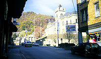 McDowell County Courthouse in Welch, West Virginia
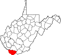
Location in the state of West Virginia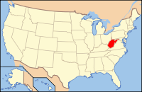
West Virginia's location in the U.S.Founded February 28, 1858 Named for James McDowell[1] Seat Welch Largest city Welch Area
- Total
- Land
- Water
535 sq mi (1,386 km²)
535 sq mi (1,386 km²)
0 sq mi (0 km²), 0.03%Population
- (2010)
- Density
22,113
20/sq mi (8/km²)Time zone Eastern: UTC-5/-4 Website www.mcdowellwv.com McDowell County is a county in the U.S. state of West Virginia. The land that became McDowell was originally part of Tazewell County, Virginia. As of the 2010 census, the population was 22,113. [2] Its county seat is Welch.[3] McDowell county is the southern-most county in the state, geographically. It was created in 1858 by the Virginia General Assembly and named for Virginia Governor James McDowell. It became a part of West Virginia in 1863, when several counties seceded from the state of Virginia during the American Civil War. McDowell County was also home of the famous Rocket Boys, who were from Coalwood.
Contents
History
Following the American Revolutionary War, the United States federal government sold acres of land within the county for as much as three cents to Wilson Cary Nicholas, Robert Morris and David Paterson, who his land to Robert Pollard. By 1795, Morris owned most of the land that is now McDowell County. The first known settlers who occupied McDowell County was the Englishman Mathias Harman and his wife who settled in a cabin in 1802. Twenty-seven years later, William Fletcher had been issued a patent for 20 acres (8.1 ha) in what is now known as Welch. McDowell County, created on February 28, 1858 from Tazewell County, Virginia, had only about 282 land owners in 1858. The first meetings within the county specified that the county seat would be Perryville, West Virginia. However, it was disputed, delaying the time when the courthouse, jail, and many other public buildings would be built. In 1867, West Virginia Legislature passed a law making the county seat near Coalwood.[1]
Five years later, the Legislature decided to allow county residents decide where the county seat should be. They decided it should be Perryville, which was then the most populous town. However, the county seat moved from Perryville to Welch because of Welch's population boom. The seat has since remained in Welch. In 1880, Welch was reported to only having three houses and one store. From 1885 to 1888, Captain Isaiah Welch surveyed the area as a potential location for a logging or mining operation. Welch, along with J. G. Bramwell and J. H. Duhring, purchased 165 acres (67 ha) of land from John Henry Hunt for 40 USD. The purchase comprised most of Welch currently. Railroads were built to the town in 1891. Afterward, Welch was incorporated and named in honor of Captain Welch in 1894. It was named after James McDowell, a member of Congress and Governor of Virginia.[1]
The county is popularly referred to as the "Free State of McDowell," a name originally coined by a local newspaper editor to refer to the unusual politics and demographics of the area.[4]
McDowell County was nationally known for its prominence in the coal mining industry, setting records for coal production and was a major player in the state's economy. Before the industry's decline that began in the 1950s, McDowell's population was almost at 100,000 residents, third highest in the state in 1950, then declined at a rapid pace in the following decades, setting the highest percentage in the state for population loss with each new census, as younger residents moved out of the county to seek better futures, leaving behind an older and increasingly impoverished population.
Through the 1960s and 1970s the demand for the county's metallurgical coal remained high. McDowell continued to lead the United States in total coal production. Increased mechanization of coal production had reduced the number of laborers employed, but miners enjoyed quality pay under improving conditions negotiated by the United Mine Workers.
While some hope for the McDowell mining economy had flourished during the energy crisis of the 1970s, in the next decade the county went from painful decline to heartbreaking collapse. Wildcat strikes in the Appalachian coal fields hindered producers in their ability to deliver to buyers. Non-unionized coal production in the western United States provided tough competition. Steel production in the United States—a major source of demand for McDowell County coal—declined, due to competition with foreign steel makers who employed newer and more efficient steel plants to produce high grade steel at lower prices.
During the decade of the 1980s the central Appalachian region lost more than 70,000 coal mining jobs. Between 1981 and 1992, according to the U.S. Department of Energy and the United Mine Workers union, coal mining employment in the state of West Virginia decreased by more than 53%. No county in the Appalachian region was more severely distressed by these losses than McDowell County. According to the United States Census Bureau, in 1980, the rate of poverty in McDowell County was 23.5%. By 1990, the poverty rate in McDowell County had climbed to 37.7%, the highest rate of poverty for any county in West Virginia. By 1990, 50.3% of all children in McDowell County were living in families below the poverty level, up from 31.2% in 1980. The major losses in McDowell County during this period were the result of the closing of all mines and facilities operated by the United States Steel Corporation, terminating more than 1,200 jobs.
The economic impact of U.S. Steel's departure was particularly dramatic: personal income in the county decreased by 66% in one year. Housing values in even the most prosperous parts of the county plunged to devastatingly low values. Individuals and families who wanted to relocate outside the county were left with little or no equity in their property. Many walked away from their mortgages and simply abandoned their homes to the lenders.
Marijuana crops, drug traffic, fraud, arson, and in one spectacular case at the Bank of Keystone—major white collar crime and embezzlement became factors in the unofficial economy of once proud McDowell. County officials also reported significant increases in the rates of domestic abuse, suicide, and Oxycontin abuse.
By 2001, stressed by declining enrollments, more than half of its children living in poverty, and major losses of tax revenue, McDowell County public schools had fallen into physical decay and high rates of academic failure. The West Virginia Department of Education intervened in December, 2001, by taking over the county system, instituting emergency funding and reorganization. The state effectively repaired or closed several school buildings, and launched construction of crucial new facilities. The consolidation of former schools into new locations, however, created new problems of busing students longer distances over narrow, winding mountain roads. New programs of teacher training aided local educators in addressing issues of multi-generational poverty in McDowell County families. Often the school system had to work at educating and stimulating hope in two or more generations at a time. With the help of the state's remedies the county school system has now returned to self-governance.
In 2001 and 2002, horrific floods leveled many of the small towns within this county. Over 10 inches (250 mm) of rain had fallen in a period of 12 hours in many of the areas. Many towns were left completely demolished by the violent flow of water which was channeled by the mountains and surrounding hills. Over 40 people died, or were declared dead as a result of being missing for over 1 year as a result of a 4 day period of rain.
In response to these economic and natural disasters, the churches of the region have organized various mission initiatives to support individuals and families in need. The largest interdenominational agency in the area, The Community Crossing, Inc (formerly known as McDowell Mission), each year hosts and organizes numerous mission work teams from many parts of the United States.
Various citizens groups and public officials have worked diligently at proposals for the rebuilding of the McDowell County economy. In recent years the county has developed profitable landfills, has lobbied for the construction of two major prisons, and has courted tourism related to popular new off-road vehicle trails through the mountains. North of the City of Welch a massive mountain-top removal site is being developed as an industrial park. That site is also the designed location for the intersection of two proposed regional highways: The Coalfields Expressway, and the King Coal Highway. The Norfolk Southern railroad corporation is bringing new construction to McDowell County enlarging the tunnels and upgrading the capacity of its main rail line between Norfolk, Virginia and the Midwest. To date, however, the largest private employer in the county is the Walmart at Big Four.
McDowell County is considered as one of the core counties in Appalachia on which the national War on Poverty focused, a national effort started during President Lyndon B. Johnson's administration.
The town of Coalwood was the hometown of Homer Hickam, a NASA engineer whose life, starting from his teenage years, was documented in Rocket Boys, which was later made into the film October Sky.
Geography
 Because of the steepness of the hills many communities within the county built in valleys, such as Gary
McDowell County, the southernmost county in West Virginia, is located at 37°22′N 81°39′W / 37.37°N 81.65°WCoordinates: 37°22′N 81°39′W / 37.37°N 81.65°W and is surrounded by Tazewell County to the south, Buchanan Country from the west, Mingo County from the northwest, Wyoming County to the north, and Mercer County to the east. The Appalachian Mountains decides most of the borders of the county.
According to the U.S. Census Bureau, the county has a total area of 535 square miles (1,390 km2), of which, 535 square miles (1,390 km2) of it is land and .1605 square miles (0.416 km2) of it (0.03%) is water. The county is roughly in the shape of a semi circle, with the border following the mountains around the county. Its county seat is the census-designated place (CDP) of Welch,[3] which is located north of the center of McDowell County.
Demographics
Historical populations Census Pop. %± 1860 1,535 — 1870 1,952 27.2% 1880 3,074 57.5% 1890 7,300 137.5% 1900 18,747 156.8% 1910 47,856 155.3% 1920 68,571 43.3% 1930 90,479 31.9% 1940 94,354 4.3% 1950 98,887 4.8% 1960 71,359 −27.8% 1970 50,666 −29.0% 1980 49,899 −1.5% 1990 35,233 −29.4% 2000 27,329 −22.4% 2010 22,113 −19.1% As of the census[5] of 2000, there were 27,329 people, 11,169 households, and 7,840 families residing in the county. The population density was 51/sq mi (20/km2). There were 13,582 housing units at an average density of 25/sq mi (10/km2). The racial makeup of the county was 87.06% White, 11.89% Black or African American, 0.17% Native American, 0.06% Asian, 0.01% Pacific Islander, 0.07% from other races, and 0.74% from two or more races. 0.48% of the population were Hispanic or Latino of any race.
There were 11,169 households out of which 29.20% had children under the age of 18 living with them, 51.10% were married couples living together, 14.90% had a female householder with no husband present, and 29.80% were non-families. 27.30% of all households were made up of individuals and 13.10% had someone living alone who was 65 years of age or older. The average household size was 2.42 and the average family size was 2.92.
In the county, the population was spread out with 23.20% under the age of 18, 7.90% from 18 to 24, 26.80% from 25 to 44, 26.10% from 45 to 64, and 16.10% who were 65 years of age or older. The median age was 40 years. For every 100 females there were 90.40 males. For every 100 females age 18 and over, there were 86.20 males.
The median income for a household in the county was $16,931, and the median income for a family was $20,496. Males had a median income of $25,994 versus $18,685 for females. The per capita income for the county was $10,174, which is the lowest in the state and the 28th lowest in the country. About 33.80% of families and 37.70% of the population were below the poverty line, including 52.50% of those under age 18 and 21.60% of those age 65 or over.
Government
Position Name Commissioner, President A. Ray Bailey Commissioner Gordon Lambert Commissioner Harold McBride Prosecuting Attorney Sid Bell Sheriff Danny Mitchell County Assessor Dennis Altizer County Clerk Donald Hicks Circuit Clerk Francine Spencer Transportation
McDowell County is served by one United States highway, which travels through Welch and continues past Maybeury toward Bluefield. However, the county has three West Virginia Routes through out the county. They are West Virginia Route 16, West Virginia Route 80 and West Virginia Route 83. The county is currently trying to construct new highways, such as U.S. Route 121, known as the Coalfields Expressway.[6] The county also had one airport, Welch Municipal Airport, which is now closed indefinitely.
Education
McDowell County Schools operates the county's public K-12 education system of 7 elementary schools, 2 middle schools, and 2 public high schools in McDowell County including Mount View High School, and River View High School. The county also has a private school, Welch Nazarene Christian Academy, which currently has 37 students enrolled.[7] The current superintendent of schools is Jim Brown. Many schools have been combined to form other schools because of the lack of revenue for the education system; therefore, some students have to travel over long distances, which because of the mountainous roads can make some trips last up to 45 minutes.
Cities and towns
Incorporated cities and towns
Unincorporated communities
- Skygusty
- Squire
- Superior
- Switchback
- Thorpe
- Twin Branch
- Union City
- Upland
- Vallscreek
- Venus
- Vivian
- Warriormine
- Wilcoe
- Worth
- Yerba
- Yukon
See also
- Anawalt Lake Wildlife Management Area
- Berwind Lake Wildlife Management Area
- National Register of Historic Places listings in McDowell County, West Virginia
- McDowell County Schools
- Panther Wildlife Management Area
- Pocahontas coalfield
References
- ^ a b c "Early History of McDowell County". McDowell County Economic Developement. http://www.polsci.wvu.edu/wv/McDowell/mcdhistory.html. Retrieved August 31, 2011.
- ^ "McDowell County, West Virginia". United States Census. June 3, 2011. http://quickfacts.census.gov/qfd/states/54/54047.html. Retrieved August 31, 2011.
- ^ a b "Find a County". National Association of Counties. http://www.naco.org/Counties/Pages/FindACounty.aspx. Retrieved 2011-06-07.
- ^ Deaner, Larry Scott (2004). [Home in the McDowell County Coalfields: The African-American Population of Keystone, West Virginia Home in the McDowell County Coalfields: The African-American Population of Keystone, West Virginia] (M.S., Geography thesis). Ohio University. Home in the McDowell County Coalfields: The African-American Population of Keystone, West Virginia. Retrieved March 20, 2011.
- ^ "American FactFinder". United States Census Bureau. http://factfinder.census.gov. Retrieved 2008-01-31.
- ^ "Coalfields Expressway". Coalfields Expressway Authority. http://www.coalfieldsexpressway.com/route/index.html. Retrieved August 31, 2011.
- ^ http://www.privateschoolreview.com/school_ov/school_id/29370
External links
- McDowell County, West Virginia
- McDowell County Board of Education
- McDowell County Commission
- McDowell County Economic Development Authority
- McDowell County Community Calendar
- McDowell County Economic Development Home Page
- McDowell County GenWeb Project
- McDowell Public Library
- ATV McDowell County

Mingo County Wyoming County Buchanan County, Virginia 
Mercer County  McDowell County, West Virginia

Tazewell County, Virginia Municipalities and communities of McDowell County, West Virginia Cities 
Towns CDPs Unincorporated
communitiesAlgoma | Antler | Apple Grove | Asco | Ashland | Atwell | Avondale | Beartown | Big Four | Bishop | Black Wolf | Bottom Creek | Canebrake | Capels | Caretta | Carlos | Carswell | Coalwood | Eckman | Elkhorn | English | Ennis | Erin | Faraday | Garland | Gilliam | Havaco | Hemphill | Hensley | Hull | Isaban‡ | Jacobs Fork | Jed | Jenkinjones | Johnnycake | Jolo | Krollitz | Kyle | Landgraff | Leckie | Lex | Lila | Litwar | Longpole | Maitland | McDowell | Mohawk | Mohegan | Monson | Newhall | Panther | Paynesville | Powhatan | Premier | Rift | Rockridge | Rolfe | Sandy Huff | Six | Skygusty | Squire | Superior | Switchback | Twin Branch | Union City | Upland | Vallscreek | Worth | Wyoming City | Yerba | Yukon
Footnotes ‡This populated place also has portions in an adjacent county or counties
Categories:- West Virginia counties
- McDowell County, West Virginia
- 1858 establishments in the United States


Wikimedia Foundation. 2010.