- Quneitra
Infobox Settlement
name =Quneitra
official_name =
other_name =
native_name =القنيطرة
nickname =
settlement_type =
total_type =
motto =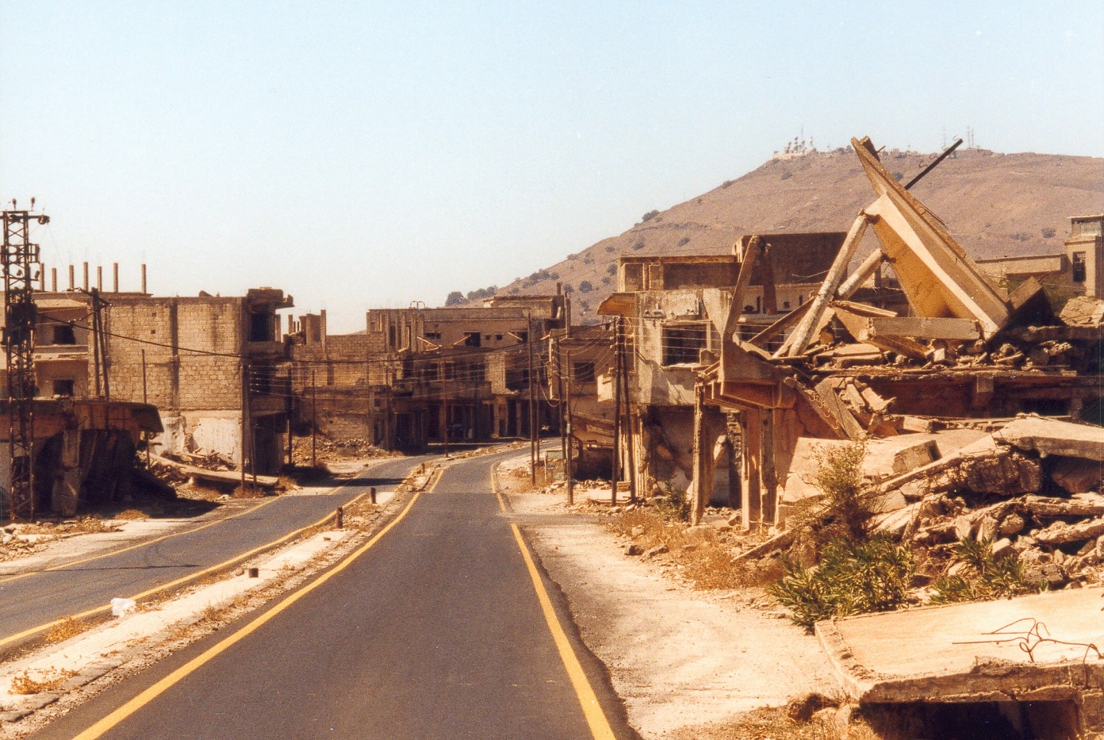
imagesize =
image_caption =
flag_size =
image_
seal_size =
image_shield =
shield_size =
image_blank_emblem =
blank_emblem_type =
blank_emblem_size =
mapsize =
map_caption =
mapsize1 =
map_caption1 =
image_dot_
dot_mapsize =
dot_map_caption =
dot_x = |dot_y =
pushpin_
pushpin_label_position =
pushpin_map_caption =Quneitra in Syria
pushpin_mapsize =
subdivision_type = Country
subdivision_name = Flag|Syria
subdivision_type1 = Governorate
subdivision_name1 = Quneitra
subdivision_type2 = District
subdivision_name2 =Quneitra District
subdivision_type3 = Region
subdivision_name3 =Golan Heights
subdivision_type4 =
subdivision_name4 =
seat_type =
seat =
parts_type =
parts_style =
parts =
p1 =
p2 =
government_footnotes =
government_type =
leader_title = Governor
leader_name =Nawaf Abboud al-Fares
leader_title1 =
leader_name1 =
leader_title2 =
leader_name2 =
leader_title3 =
leader_name3 =
leader_title4 =
leader_name4 =
established_title = Settled
established_date = around AD 1000
established_title1 = Destroyed
established_date1 = 1974
established_title2 =
established_date2 =
established_title3 =
established_date3 =
founder =
named_for =
area_magnitude =
unit_pref =
area_footnotes =
area_total_km2 =
area_land_km2 =
area_water_km2 =
area_total_dunam =
area_total_sq_mi =
area_land_sq_mi =
area_water_sq_mi =
area_water_percent =
area_urban_km2 =
area_urban_sq_mi =
area_metro_km2 =
area_metro_sq_mi =
area_blank1_title =
area_blank1_km2 =
area_blank1_sq_mi =
elevation_footnotes =
elevation_m =
elevation_ft =3313
elevation_max_m =
elevation_max_ft =
elevation_min_m =
elevation_min_ft =
population_as_of =
population_footnotes =
population_note =
population_total =
population_density_km2 =
population_density_sq_mi =
population_metro =
population_density_metro_km2 =
population_density_metro_sq_mi =
population_urban =
population_density_urban_km2 =
population_density_urban_sq_mi =
population_blank1_title =
population_blank1 =
population_density_blank1_km2 =
population_density_blank1_sq_mi =
timezone = EET
utc_offset = +2
timezone_DST =EEST
utc_offset_DST = +3
coor_type =
latd=33 |latm=07 |lats= |latNS=N
longd=35 |longm=49 |longs= |longEW=E
postal_code_type =
postal_code =
area_code =43
blank_name =
blank_info =
blank1_name =
blank1_info =
blank2_name =
blank2_info =
blank3_name =
blank3_info =
blank4_name =
blank4_info =
blank5_name =
blank5_info =
blank6_name =
blank6_info =
website = [http://www.equnaytra.sy/ eQunaytra]
footnotes = Quneitra (also Al Qunaytirah, Qunaitira, or Kuneitra; _ar. القنيطرة) is the largely destroyed and abandonedcapital of theQuneitra Governorate in south-westernSyria . It is situated in a high valley in theGolan Heights at an elevation of 1,010 metres (3,313 feet) above sea level. Quneitra was founded in the Ottoman era as a way station on the caravan route toDamascus and subsequently became a garrison town of some 20,000 people, strategically located near the border withIsrael .On 10 June 1967, the last day of the
Six-Day War , Quneitra came under Israeli control. [On 10 June, Israeli authorities utilized apostmark , in Arabic, English and Hebrew, for mail sent from Quneitra. Livni, Israel. "Encyclopedia of Israel Stamps." Tel Aviv: Sifriyat Ma'arit, 1969. p.195] It was briefly recaptured by Syria during the 1973Yom Kippur War , but Israel regained control in its subsequent counter-offensive. The city was almost completely destroyed before the Israeli withdrawal in June 1974. It now lies in the demilitarized United Nations Disengagement Observer Force (UNDOF) Zone between Syria and Israel, a short distance from the "de facto" border between the two countries. Israel was heavily criticized by theUnited Nations for the city's destruction," [http://domino.un.org/UNISPAL.NSF/1ce874ab1832a53e852570bb006dfaf6/5b1bc7e46c040df7852560de0054e654!OpenDocument Report of the Special Committee to Investigate Israeli Practices Affecting the Human Rights of the Population of the Occupied Territories] ", UNGA Resolution 3240, 29 November 1974"] while Israel has also criticized Syria for not rebuilding Quneitra. [Abraham Rabinovich. "The Yom Kippur War", 492. Knopf Publishing Group, 2005. ISBN 0805211241]Political status
Quneitra is the capital of the
Quneitra Governorate , a district of southwestern Syria that incorporates the whole of the Golan Heights. The city of Quneitra is interior to the portion of the Golan Heights controlled by Syria. "Qunaytirah, Al-." Encyclopædia Britannica. 1993] Israel claims sovereignty over the portion of the Golan Heights that it controls, but this has not been recognised by any other country and the area is regarded as occupied territory under international law"Golan Heights" "A Dictionary of Contemporary World History". Jan Palmowski. Oxford University Press, 2003. Oxford Reference Online. Oxford University Press.] ; for the politico-legal status of the Golan Heights area, seeInternational law and the Arab-Israeli conflict .Geography and demographics
Quneitra is situated in a high valley in the Golan Heights at an altitude of 942 m (3,091 ft) above sea level. It is overshadowed to the west by the Israeli-held portion of the Golan Heights and the peak of Har Bental. The surrounding area is dominated by ancient volcanic lava flows interspersed by a number of dormant
volcanic cone s which rise some 150-200 m (500-700 ft) above the surrounding plain. The volcanic hills of the region have played a key role as observation points and natural firing positions in the conflicts over the region, most notably in the Yom Kippur War. [Simon Dunstan. "The Yom Kippur War 1973: The Sinai", p. 9. Osprey Publishing, 2003. ISBN 1841762202] In more peaceful times, the fertile volcanic soil has supported agricultural activities such aswheat growing andpastoralism .Geoffrey William Bromiley. "Golan", in "International Standard Bible Encyclopedia: E-J", p. 520. Wm. B. Eerdmans Publishing, 1994. ISBN 0802837824] Writing during the inter-war period, the American traveller Harriet-Louise H. Patterson recorded that Quneitra was:charmingly set in a grove of
eucalyptus trees. Its chief claim to charm or the few moments of a traveller's time beyond passport formalities is the beautiful vista which it offers of Jordan as it flows down from Hermon through banks of tangled bush and flowering pink and white oleanders. Kuneitra is pleasant as a stopping-place for lunch. It is cool under the spreading trees, usually quiet and restful. [Harriet-Louise H. Patterson, "Around The Mediterranean With My Bible". W. A. Wilde Co., 1941]The city's position on an important trade route gave it a varied population for much of its history. By the start of the 20th century it was dominated by Muslim
Circassians from theCaucasus . Its population grew to some 21,000 people, mostlyArab s, following Syrian independence from France in 1946. After its abandonment in 1967 and subsequent destruction, its population was dispersed to other parts of Syria. The city remains abandoned apart from a residual Syrian security presence.History
Early history
The surrounding area has been inhabited for millennia.
Palaeolithic hunter-gatherers are thought to have lived there, as evidenced by the discovery of Levallois andMousterian flint tools in the vicinity. [Takeru Akazawa, Kenichi Aoki, Ofer Bar-Yosef, "Neanderthals and Modern Humans in Western Asia", p. 154. Springer, 1998. ISBN 0306459248] A settlement was established at least as early as Roman and Byzantine times, serving as a stop on the road fromDamascus to westernPalestine . Saint Paul is said to have passed through the settlement on his way fromJerusalem to Damascus. The site of theConversion of Paul was traditionally identified with the small village of Kokab, north-east of Quneitra, on the road to Damascus. [Ivan Mannheim, "Biblical Damascus", in "Syria & Lebanon Handbook", p. 100. 2001, Footprint Travel Guides. ISBN 1900949903]The modern city grew around the nucleus of an Ottoman
Caravanserai , which was built using the stones of the ruined ancient settlement.Paul Virgil McCracken Flesher, Dan Urman, "Ancient Synagogues: historical analysis and archaeological discovery", p. 394. Brill Academic Publishers, 1995. ISBN 9004112545] By the 20th century Quneitra had become the administrative centre for the Golan region and a centre of settlement for MuslimCircassians from theCaucasus .During
World War I , theAustralian Mounted Division and 5th Cavary Division defeated the Ottoman Turks there on 29 September 1918, before they took Damascus [cite news | url=http://sill-www.army.mil/famag/1928/MAY_JUN_1928/MAY_JUN_1928_PAGES_255_271.pdf| title=CAMPAIGN SUMMARY AND NOTES ON HORSE ARTILLERY IN SINAI AND PALESTINE| publisher= Field Artillery Journal | date= MAY JUNE 1928 |format=PDF] (see alsoBattle of Megiddo (1918) ). Quneitra saw several battles during theSyria-Lebanon Campaign of Second World War, including theBattle of Damascus andBattle of Kissoué . [ cite book |author=Compton Mackenzie |authorlink=Compton Mackenzie |title=Eastern Epic |location=London |year=1951 |publisher=Chatto & Windus|pages=605 pages ]Arab-Israeli conflict
When the modern states of Syria and Israel gained their independence from France and Britain respectively after the Second World War, Quneitra gained a new strategic significance as a key road junction some 40 miles (64 km) from the border. It became a prosperous market town and military garrison, with its population tripling to over 20,000 people, predominately Arabs."Qunaytirah, Al-." Encyclopædia Britannica. 2007.]
ix-Day War
Quneitra was the Syrian headquarters for the Golan Heights. [cite news |title=A Campaign for the Books |publisher=Time Magazine |date=1 September 1967 |url=http://www.time.com/time/magazine/article/0,9171,837237,00.html] The Israeli capture of the city occurred in chaotic circumstances on 10 June 1967, the last day of the
Six-Day War . Israeli forces advancing towards Quneitra from the north-west prompted Syrian troops to deploy north of the city, under heavy bombardment, to defend the road to Damascus. At nowrap|8:45 a.m., Syrian radio mistakenly broadcast an announcement that the city had fallen. Alarmed, the Syrian Army's redeployment turned into a chaotic retreat along the Damascus road. Although a correction was broadcast two hours later, the Israelis took advantage of the confusion to seize Quneitra.Andrew Beattie, Timothy Pepper, "The Rough Guide to Syria" 2nd edition, p. 146. Rough Guides, 2001. ISBN 1858287189] An armoured brigade under ColonelAlbert Mandler entered Quneitra at nowrap|2:30 p.m. and found the city deserted and strewn with abandoned military equipment. One of the Israeli commanders later commented:We arrived almost without hindrance to the gates of Quneitra ... All around us there were huge quantities of booty. Everything was in working order. Tanks with their engines still running, communication equipment still in operation had been abandoned. We captured Quneitra without a fight. [Jeremy Bowen, "Six Days: How the 1967 War Shaped the Middle East", p. 304. Simon & Schuster Ltd, 2003. ISBN 0743230957]
"Time" magazine reported: "In an effort to pressure the United Nations into enforcing a ceasefire, Damascus Radio undercut its own army by broadcasting the fall of the city of El Quneitra three hours before it actually capitulated. That premature report of the surrender of their headquarters destroyed the morale of the Syrian troops left in the Golan area." [cite news |title=A Campaign for the Books |publisher=Time Magazine |date=September 1, 1967 |url=http://www.time.com/time/printout/0,8816,837237,00]
A ceasefire was agreed later in the afternoon, leaving Quneitra under Israeli control. In June 1967, "Time" magazine reported: "The city of El Quneitra was a ghost town, its shops shuttered, its deserted streets patrolled by Israelis on house-to-house searches for caches of arms and ammunition. The hills echoed/with explosions as Israeli sappers systematically destroyed the miniature Maginot line from which the Syrians had shelled kibbutzim across the Sea of Galilee." [cite news |title=Coping with Victory |publisher=Time Magazine |date=23 June 1967 |url=http://www.time.com/time/magazine/article/0,9171,839520,00.html]
The United Nations Special Representative
Nils-Goran Gussing visited it in July and reported that "nearly every shop and every house seemed to have been broken into and looted" and that some buildings had been set on fire after they had been stripped. Although Israeli spokesmen told Gussing that Quneitra had actually been looted by the withdrawing Syrians, the UN representative viewed this as unlikely given the extremely short space of time between the erroneous radio announcement and the fall of the city a few hours later. He concluded that "responsibility for this extensive looting of the town of Quneitra lay to a great extent with the Israeli forces." [Bowen, "ibid".]Israeli-occupation
The deserted city remained in Israeli hands for the next six years. However, Israel and Syria remained in a state of war throughout this period (and, indeed, to the present day). The town gained a fresh symbolic value; it was seen by the Syrians as "the badge of Syria's defeat, an emblem of hatred between Syria and Israel and a cross [Syrian President
Hafez al-Assad ] had to bear." [Seale, Patrick. (1988). Asad of Syria: The struggle for the Middle East (p. 141). Berkeley: University of California Press] Syria shelled the city several times during the early 1970s; in June 1970 a Syrian armored unit launched an attack, [cite news |title=Israel and Syria battle third day in the Golan area | publisher= The New York Times | date= 27 June 1970 | url=http://select.nytimes.com/gst/abstract.html?res=F10917F8395B16768FDDAE0A94DE405B808BF1D3 | author= Charles Mohr] and in November 1972, Damascus radio announced that Syrianartillery had again shelled Quneitra. [cite news |title=Syria Shells Israeli Bases in Occupied Golan Heights| publisher= The New York Times | date= 26 November 1972| url=http://select.nytimes.com/gst/abstract.html?res=F70F16FE345910738DDDAF0A94D9415B828BF1D3]Yom Kippur War
During the first few days of the
Yom Kippur War in 1973, Quneitra was briefly recaptured by the Syrian Army before it was repulsed in an Israeli counter-offensive. ["Tables turned on Arabs, Israel general says". "The Times", 9 October 1973, p. 8] In the middle of October 1973 the Israeli counter-offensive started. The Syrians had massed nearly 1,000tank s along a 60-mile front. With a massive concentration of tanks, the Israelis lashed into the Syrian forces. The Syrians at first fell back, but then managed to counterattack and drive back into occupied territory. Quneitra changed hands several times. Finally, Israeli armored units, closely supported by Phantoms and Skyhawks performingclose air support withnapalm strikes against the forward Syrian units, halted the Syrian drive and turned the Arabs back. [cite news |title=The War of the Day of Judgment| publisher= Time Magazine| date= October 22, 1973| url=http://www.time.com/time/magazine/article/0,9171,908039,00.html]Israeli control continued to hold the city until early June 1974, when it was returned to Syrian civilian control following the signature of a United States-brokered disengagement agreement signed on 31 May 1974. The surrender of Quneitra was controversial, with Israeli settlers"Settlers insist Israel keeps Golan". "The Times", 7 May 1974, p. 6] and the
Likud andNational Religious Party opposing it ["Criticism in Israel over peace pact's concessions to Syria". "The Times", 30 May 1974, p. 7] and even establishing a settlement on its outskirts for a brief period (see Keshet). The agreement provided that the city was to be repopulated to serve as evidence of peaceful Syrian intentions, by creating a hostage to Syrian good behaviour which would encourage the Israelis to pull back further. [Michael Mandelbaum, "The Fate of Nations: The Search for National Security in the Nineteenth and Twentieth Centuries", p. 316. Cambridge University Press, 1988. ISBN 052135790X] The disengagement went into force on 6 June. ["Israel-Syrian disengagement goes into effect today after detailed plan is signed in Geneva". "The Times", 6 June 1974, p. 6] On 26 June, the Syrian presidentHafez al-Assad travelled to Quneitra, where he pledged to rebuild the city and reclaim the rest of the occupied territories. ["Egypt offers air force to defend Lebanon". "The Times", 26 June 1974, p. 6]Return to Syrian control
Western reporters accompanied Syrian refugees returning to the city in early July 1974 and described what they saw on the ground. "Time" magazine's correspondent reported that "Most of its buildings are knocked flat, as though by dynamite, or pockmarked by shellfire." [cite news |title=Returning to Quneitra| publisher= Time Magazine| date= 8 July 1974| url=http://www.time.com/time/magazine/article/0,9171,943909,00.html] "
Le Monde "'s Syria correspondent, in a report for "The Times ", gave a detailed eyewitness description of the destruction:Today the city is unrecognisable. The houses with their roofs lying on the ground look like gravestones. Part of the rubble is covered with fresh earth furrowed by bulldozer tracks. Everywhere there are fragments of furniture, discarded kitchen utensils, Hebrew newspapers dating from the first week of June; here a ripped-up mattress, there the springs of an old sofa. On the few sections of wall still standing, Hebrew inscriptions proclaim: "There'll be another round"; "You want Quneitra, you'll have it destroyed.""Golan's capital turns into heap of stones". "The Times", 10 July 1974, p. 8]
The city had reportedly been systematically stripped by the Israeli forces, with anything movable being removed and sold to Israeli contractors. The empty buildings were subsequently pulled apart with tractors and bulldozers. [Lara Dunston, Terry Carter, Andrew Humphreys. "Syria & Lebanon", p. 129. Lonely Planet, 2004. ISBN 1864503335] Speculating on the possible reasons for the razing of the city, "The Times"' correspondent noted in 1974 that "the Israeli evacuation of Quneitra took place soon after the return of Israeli prisoners of war from Damascus with many stories of torture," a claim that Syria denied.
Israel asserted that most of the damage had been caused in the two wars and during the artillery duels in between. ["Israel fears Russian incitement of Arabs". "The Times", 8 September 1975] [cite news |title=Corrections | publisher= The New York Times | date= 9 May 2001 |url=http://query.nytimes.com/gst/fullpage.html?res=9801E7DB153BF93AA35756C0A9679C8B63] Several reports from before the withdrawal did refer to the city as "ruined" and "shell-scarred". ["Syrian 160mm mortar shells were falling on the northern side of the city, a shell-scarred ghost city since its capture by the Israelis in 1967". "Debris of two armies litters Damascus road". "The Times", 5 October 1973] ["Kuneitra, the ruined capital of the Heights". "Village life on the wild frontier of the Golan". "The Times", 5 April 1974] ["The officer conceded that the ruined city itself was of no military importance to Israel." "Israel sees no end to Golan battle". "The Times", 2 May 1974. ] "The Times"' correspondent saw the city for himself on 6 May, a month before the Israeli withdrawal, and described it as being "in ruins and deserted after seven years of war and dereliction. It looks like a wild west city struck by an earthquake and if the Syrians get it back they will face a major feat of reconstruction. Nearly every building is heavily damaged and scores have collapsed."
Direct evidence of the city's condition was provided when it was filmed on 12 May 1974 by a British television news team which included the veteran journalist
Peter Snow , who was reporting forIndependent Television News on the disengagement negotiations. His report was broadcast on ITN's "News at Ten " programme. According to "The Times"' correspondentEdward Mortimer , "viewers were thus afforded a panoramic view of the city, which had stood almost completely empty since the Syrian army evacuated it in 1967. It could be seen that many of the buildings were damaged, but most of them were still standing." After it was handed over, "very few buildings were left standing. Most of those destroyed did not present the jagged outline and random heaps of rubble usually produced by artillery or aerial bombardment. The roofs lay flat on the ground, 'pancaked' in a manner which I am told can only be achieved by systematic dynamiting of the support walls inside." Mortimer concluded that the footage "establishes beyond reasonable doubt that much of the destruction took place after 12 May—at a time when there was no fighting anywhere near Kuneitra." ["A question mark over the death of a city." "The Times", 17 February 1975, p. 12]The
United Nations established a "Special Committee to Investigate Israeli Practices Affecting the Human Rights of the Population of the Occupied Territories", which concluded that Israeli forces had deliberately destroyed the city prior to their withdrawal. The report's conclusions were subsequently adopted by theUnited Nations General Assembly . It passed a resolution on 29 November 1974 describing the destruction of Quneitra as "a grave breach of the [Fourth] Geneva Convention" and "condemn [ing] Israel for such acts," by a margin of 93 votes to 8, with 74 abstentions. TheUnited Nations Commission on Human Rights also voted to condemn the "deliberate destruction and devastation" of Quneitra in a resolution of 22 February 1975, by a margin of 22 votes to one (the United States) with nine abstentions."Human Rights Commission condemns Israel". "The Times", 22 February 1975]The city today
[
 Rough Guide to Syria" describes the current appearance of the city: "The first sight of the flattened houses on Quneitra's outskirts is the most dramatic; many of the unscathed roofs simply lie on top of a mass of rubble, leaving the impression of a building that has imploded."
The city has often been used as a stop for foreign VIPs, ranging from the Soviet foreign minister
Alexei Kosygin in June 1976 ["Syrians offered Soviet support by Mr Kosygin". "The Times", 4 June 1976, p. 6] toPope John Paul II in May 2001. [" [http://news.bbc.co.uk/1/hi/world/middle_east/1315453.stm Pope visits Golan Heights] ". BBC News, 7 May 2001] Only a handful of families now live in the town, making a living by providing services for the United Nations troops patrolling the demilitarized zone. ["Pope prays for peace in war-torn Syrian town", "News Letter" (Belfast); 8 May 2001; p. 17] According to "The Times", "the carefully preserved ruined city has become a pilgrimage site for a generation of Syrians." ["Silence of Syria's forgotten siege", "The Times"; 8 May 2001; p. 15]The city can be visited by tourists, but a permit from the
Syrian Ministry of the Interior is required, and sight-seeing is supervised by a military guide. The principal sights on the standard tour are the remains of Quneitra's hospital, mosque and Greek Orthodox church. A "Liberated Quneitra Museum", displaying artifacts from the city's ancient and medieval past, is housed in the former Ottomancaravanserai in the city centre. The western edge of the city marks the start of "no-man's land" beyond which lies Israeli-controlled territory. Because the border is closed, it is not possible to visit Quneitra from Israel.Ivan Mannheim, "Syria & Lebanon Handbook", p. 142. 2001, Footprint Travel Guides. ISBN 1900949903]ee also
*
Quneitra Crossing
*Shebaa Farms Further reading
*Goren-Inbar, N., and Paul Goldberg. "Quneitra: A Mousterian Site on the Golan Heights". Publications of the Institute of Archaeology, the Hebrew University of Jerusalem, 31. [Jerusalem] : Institute of Archaeology, Hebrew University of Jerusalem, 1990.
References
External links
News & Events
* [http://www.equnaytra.sy qunaytra ] The First Complete website for qunaytra news and services
Governmental Services
* [http://www.e.sy E.sy ] The First Complete Governmental Online Services
Links
* [http://maps.google.com/maps?ll=33.125556,35.823889&spn=0.1,0.1&t=k&q=33.125556,35.823889 Satellite view of Quneitra] (
Google Maps )
*Pictures of [http://web.mac.com/dwb217/iWeb/WorldViewBender/Syrian%20Golan%20Heights.html Queitra]

Wikimedia Foundation. 2010.