- Geography of El Salvador
-
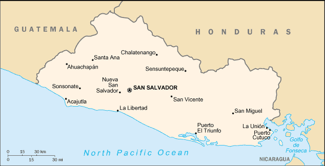
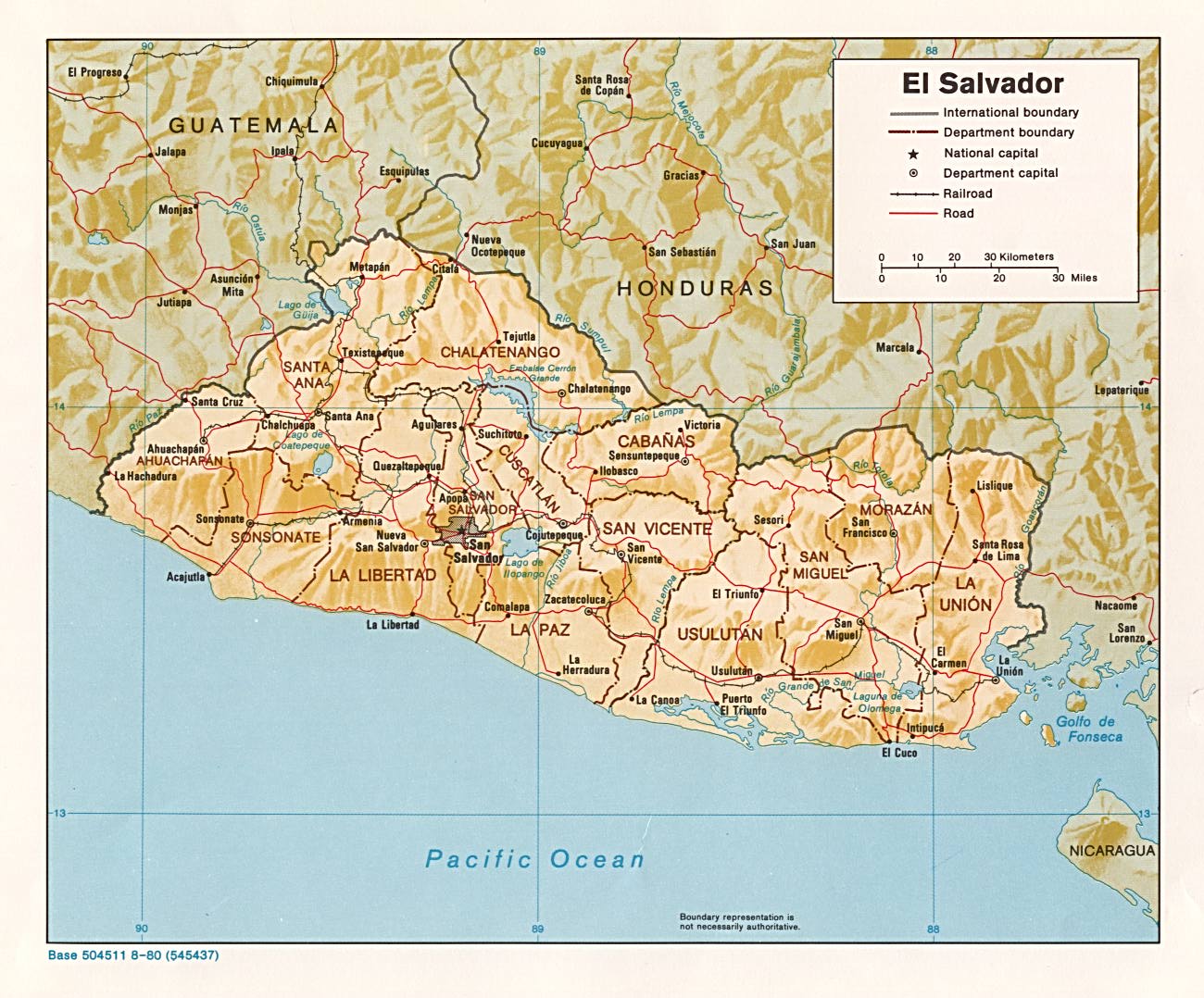
 Map of El Salvador
 Shaded relief map of El Salvador
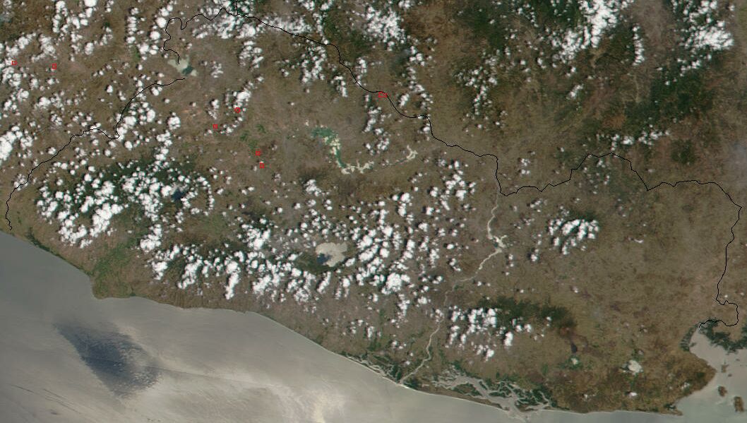
 Satellite image of El Salvador in April 2002
 Economic activity of El Salvador, 1980
 Vegetation and land use, 1980
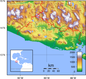 Topography of El Salvador
The geography of El Salvador is unique among the nations of Central America. The country borders the North Pacific Ocean to the south and southwest, with Guatemala to the north-northwest and Honduras to the north-northeast. In the southeast, the Golfo de Fonseca separates it from Nicaragua. El Salvador is the smallest Central American country in area and is the only one without a coastline on the Caribbean sea.
Geographic coordinates: 13°50′N 88°55′W / 13.833°N 88.917°W
El Salvador, along with the rest of Central America, is one of the most seismologically active regions on earth, situated atop three of the large tectonic plates that constitute the Earth's surface. The motion of these plates causes the area's earthquake and volcanic activity.
Most Central America and the Caribbean Basin rests on the relatively motionless Caribbean Plate. The Pacific Ocean floor, however, is being carried northeast by the underlying motion of the Cocos Plate. Ocean floor material is largely composed of basalt, which is relatively dense; when it strikes the lighter granite rocks of Central America, the ocean floor is forced down under the land mass, creating the deep Middle America Trench that lies off the coast of El Salvador. The subduction of the Cocos Plate accounts for the frequency of earthquakes near the coast. As the rocks constituting the ocean floor are forced down, they melt, and the molten material pours up through weaknesses in the surface rock, producing volcanoes and geysers.
North of El Salvador, Mexico and most of Guatemala are riding on the westward-moving North American Plate that butts against the northern edge of the stationary Caribbean Plate in southern Guatemala. The grinding action of these two plates creates a fault, similar to the San Andreas fault in California, that runs the length of the valley of the Rio Motagua in Guatemala. Motion along this fault is the source of earthquakes in northernmost El Salvador.
El Salvador has a long history of destructive earthquakes and volcanic eruptions. San Salvador was destroyed in 1756 and 1854, and it suffered heavy damage in the 1919, 1982, and 1986 tremors. The country has over twenty volcanoes, although only two, San Miguel and Izalco, have been active in recent years. From the early nineteenth century to the mid 1950s, Izalco erupted with a regularity that earned it the name "Lighthouse of the Pacific." Its brilliant flares were clearly visible for great distances at sea, and at night its glowing lava turned it into a brilliant luminous cone.
Contents
Physical features
Two parallel mountain ranges cross El Salvador to west with a central plateau between them and a narrow coastal plain hugging the Pacific. These physical features divide the country into two physiographic regions. The mountain ranges and central plateau, covering 85 percent of the land, comprise the interior highlands. The remaining coastal plains are referred to as the Pacific lowlands.
The northern range of mountains, the Sierra Madre, form a continuous chain along the border with Honduras. Elevations in this region range from 1,600 to 2,700 meters. The area was once heavily forested, but overexploitation led to extensive erosion, and it has become semibarren. As a result, it is the country's most sparsely populated zone, with little farming or other development.
The southern range of mountains is actually a discontinuous chain of more than twenty volcanoes, clustered into five groups. The westernmost group, near the Guatemalan border, contains Izalco and Santa Ana, which at 2,365 meters is the highest volcano in El Salvador. Between the cones lie alluvial basins and rolling hills eroded from ash deposits. The volcanic soil is rich, and much of El Salvador's coffee is planted on these slopes.
The central plateau constitutes only 25 percent of the land area but contains the heaviest concentration of population and the country's largest cities. This plain is about 50 kilometers wide and has an average elevation of 600 meters. Terrain here is rolling, with occasional escarpments, lava fields, and geysers.
A narrow plain extends from the coastal volcanic range to the Pacific Ocean. This region has a width ranging from one to thirty-two kilometers with the widest section in the east, adjacent to the Golfo de Fonseca. Near La Libertad, however, the mountains pinch the lowlands out; the slopes of adjacent volcanoes come down directly to the ocean. Surfaces in the Pacific lowlands are generally flat or gently rolling and result from alluvial deposits from nearby slopes.
El Salvador has over 300 rivers, the most important of which is the Rio Lempa. Originating in Guatemala, the Rio Lempa cuts across the northern range of mountains, flows along much of the central plateau, and finally cuts through the southern volcanic range to empty into the Pacific. It is El Salvador's only navigable river, and it and its tributaries drain about half the country. Other rivers are generally short and drain the Pacific lowlands or flow from the central plateau through gaps in the southern mountain range to the Pacific.
Numerous lakes of volcanic origin are found in the interior highlands; many of these lakes are surrounded by mountains and have high, steep banks. The largest lake, the Lago de Ilopango, lies just to the east of the capital. Other large lakes include the Lago de Coatepeque in the west and the Lago de Güija on the Guatemalan border. The Cerron Grande Dam on the Rio Lempa has created a large reservoir, the Embalse Cerron Grande, in northern El Salvador.
Izalco has erupted at least 51 times since 1770. It earned the nickname "Lighthouse of the Pacific" because it was the most active volcano in Central America.
Climate
El Salvador has a tropical climate with pronounced wet and dry seasons. Temperatures vary primarily with elevation and show little seasonal change. The Pacific lowlands are uniformly hot; the central plateau and mountain areas are more moderate.
The rainy season, known locally as invierno, or winter, extends from May to October. Almost all the annual rainfall occurs during this time, and yearly totals, particularly on southern-facing mountain slopes, can be as high as 2,000 millimeters (78.7 in). Protected areas and the central plateau receive lesser, although still significant, amounts. Rainfall during this season generally comes from low pressure over the Pacific and usually falls in heavy afternoon thunderstorms. Although hurricanes occasionally form in the Pacific, they seldom affect El Salvador, with the notable exception of Hurricane Mitch and Hurricane Emily in 1998.
From November through April, the northeast trade winds control weather patterns. During these months, air flowing from the Caribbean has had most of the precipitation wrung out of it while passing over the mountains in Honduras. By the time this air reaches El Salvador, it is dry, hot, and hazy. This season is known locally as verano, or summer.
Temperatures vary little with season; elevation is the primary determinant. The Pacific lowlands are the hottest region, with annual averages ranging from 25 to 29 °C (77 to 84.2 °F). San Salvador is representative of the central plateau, with an annual average temperature of 23 °C (73 °F) and absolute high and low readings of 38 and 6 °C (100.4 and 42.8 °F), respectively. Mountain areas are the coolest, with annual averages from 12 to 23 °C (53.6 to 73.4 °F) and minimum temperatures sometimes approaching freezing.
Other facts
The total land area of El Salvador is 23,040 km², with 22,720 km² of land and 320 km² of water. This is slightly smaller than the U.S. state of Massachusetts. El Salvador has 545 km of borders, including 342 km of borders with Honduras and 203 km with Guatemala. El Salvador has a coastline of 307 km.
El Salvador claims a territorial sea of 200 nautical miles (370.4 km; 230.2 mi).
Climate: tropical; rainy season (May to October); dry season (November to April); tropical on coast; temperate in uplands
Terrain: mostly mountains with narrow coastal belt and central plateau
The lower point of elevation in El Salvador is the Pacific Ocean, at sea level. The highest point is Cerro El Pital, at 2,730 m.
Natural resources: hydropower, geothermal power, petroleum, arable land
Land use (1993 estimate) includes 29 percent permanent pasture, 27 percent arable land, 8 percent permant crops, 5 percent forests and woodland, and 31 percent other.
Irrigated land: 1,200 km² (1993 est.)
Natural hazards: El Salvador is known as the Land of Volcanoes; there are frequent and sometimes very destructive earthquakes and volcanic activity; catastophic hurricanes are uncommon.
Environment - current issues: deforestation; soil erosion; water pollution; contamination of soils from disposal of toxic wastes; Hurricane Mitch damage
El Salvador is party to the Convention on Biological Diversity, United Nations Framework Convention on Climate Change, Kyoto Protocol to the United Nations Framework Convention on Climate Change, United Nations Convention to Combat Desertification, CITES, Basel Convention, Partial Test Ban Treaty, Montreal Protocol, Ramsar Convention. El Salvador has signed, but not ratified the United Nations Convention on the Law of the Sea.
References
 This article incorporates public domain material from websites or documents of the Library of Congress Country Studies.
- This article incorporates public domain material from websites or documents of the CIA World Factbook.
Sovereign states Antigua and Barbuda · Bahamas · Barbados · Belize · Canada · Costa Rica · Cuba · Dominica · Dominican Republic · El Salvador · Grenada · Guatemala · Haiti · Honduras · Jamaica · Mexico · Nicaragua · Panama · Saint Kitts and Nevis · Saint Lucia · Saint Vincent and the Grenadines · Trinidad and Tobago · United States
Dependencies and
other territoriesAnguilla · Aruba · Bermuda · Bonaire · British Virgin Islands · Cayman Islands · Curaçao · Greenland · Guadeloupe · Martinique · Montserrat · Navassa Island · Puerto Rico · Saint Barthélemy · Saint Martin · Saint Pierre and Miquelon · Saba · Sint Eustatius · Sint Maarten · Turks and Caicos Islands · United States Virgin Islands
Climate of North America Sovereign states Antigua and Barbuda · Bahamas · Barbados · Belize · Canada · Costa Rica · Cuba · Dominica · Dominican Republic · El Salvador · Grenada · Guatemala · Haiti · Honduras · Jamaica · Mexico · Nicaragua · Panama · Saint Kitts and Nevis · Saint Lucia · Saint Vincent and the Grenadines · Trinidad and Tobago · United States
Dependencies and
other territoriesAnguilla · Aruba · Bermuda · Bonaire · British Virgin Islands · Cayman Islands · Curaçao · Greenland · Guadeloupe · Martinique · Montserrat · Puerto Rico · Saint Barthélemy · Saint Martin · Saint Pierre and Miquelon · Saba · Sint Eustatius · Sint Maarten · Turks and Caicos Islands · United States Virgin Islands
Categories:


Wikimedia Foundation. 2010.