- Valles Marineris
-
Valles Marineris 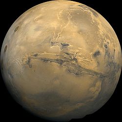
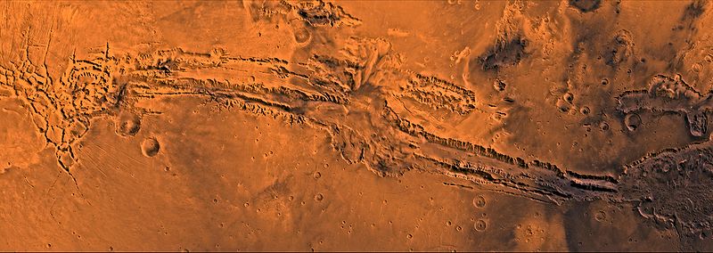
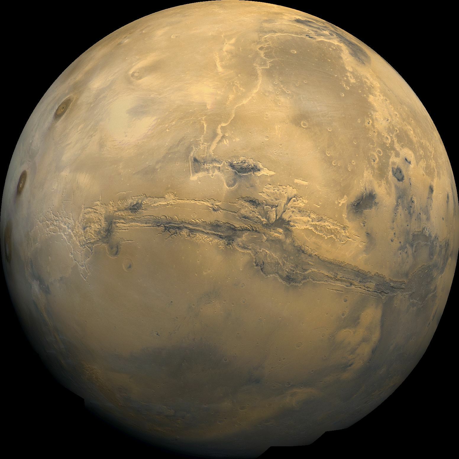
Valles Marineris cuts a wide gash across the face of MarsCoordinates 13°54′S 59°12′W / 13.9°S 59.2°WCoordinates: 13°54′S 59°12′W / 13.9°S 59.2°W Length approx. 4,000 kilometres (2,500 mi) Naming Mariner 9 Valles Marineris (Latin for Mariner Valleys, named after the Mariner 9 Mars orbiter of 1971–72 which discovered it) is a system of canyons that runs along the Martian surface east of the Tharsis region. At more than 4,000 km long, 200 km wide and up to 7 km deep,[1][2] the Valles Marineris rift system is one of the larger canyons of the Solar System, surpassed only by the rift valleys of Earth and (in length only) by Baltis Vallis on Venus.
Valles Marineris is located along the equator of Mars, on the east side of the Tharsis Bulge, and stretches for nearly a quarter of the planet’s circumference. The Valles Marineris system starts in the west with the Noctis Labyrinthus; proceeding to the east are Tithonium and Ius chasmata, then Melas and Ophir chasmata, then Coprates Chasma, then Ganges, Capri and Eos chasmata; finally it empties into an outflow channel region containing chaotic terrain that ends in the basin of Chryse Planitia. Most researchers agree that Valles Marineris is a large tectonic "crack" in the Martian crust that formed as the crust rose in the Tharsis region to the west, and was subsequently widened by erosional forces. However, near the eastern flanks of the rift there appear to be some channels that may have been formed by water or carbon dioxide.
Contents
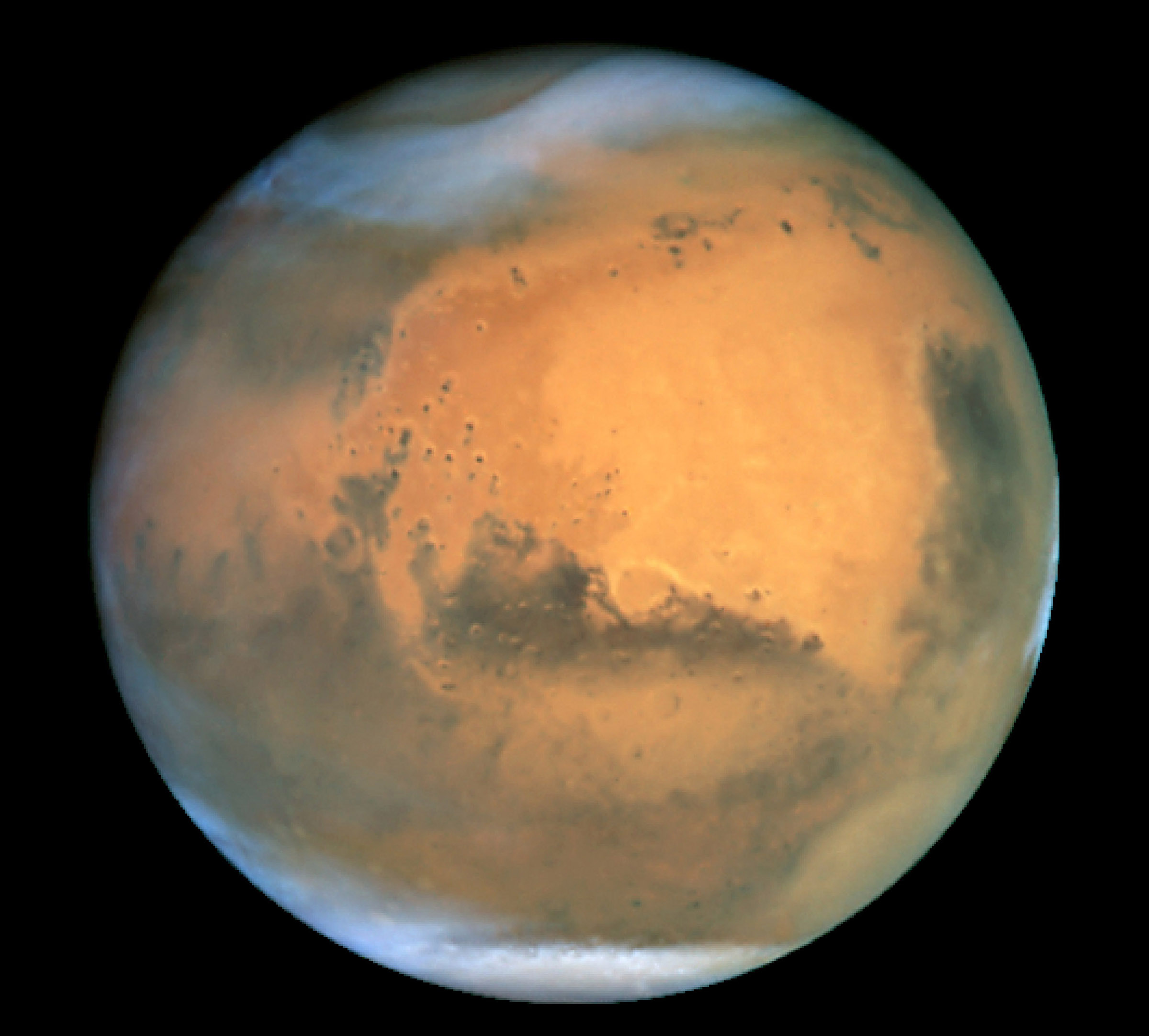
 Valles Marineris. Image courtesy NASA/JPL-Caltech
Formation
 Valles Marineris. Image from NASA World Wind
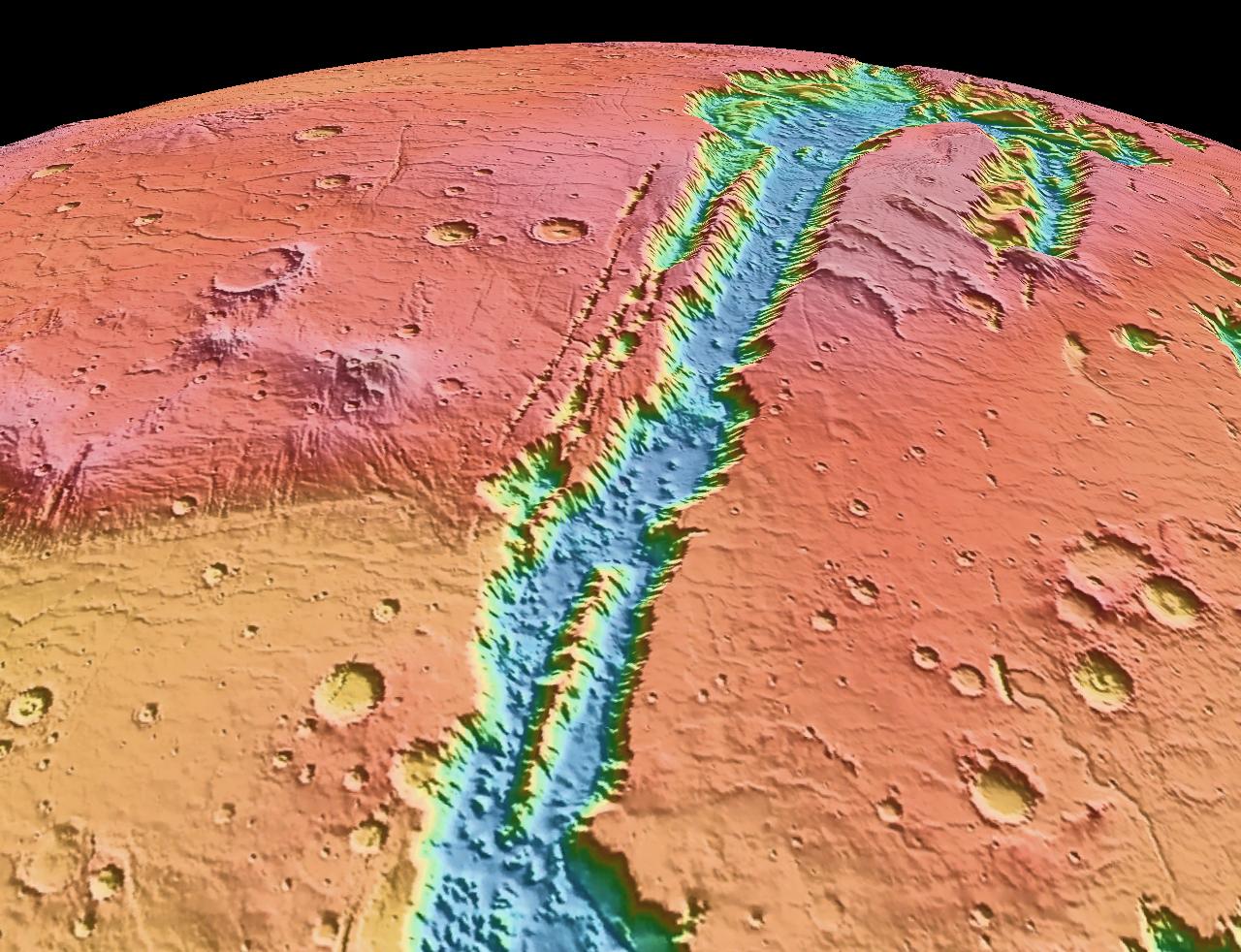
 Topographic map of Valles Marineris
There have been many different theories about the formation of Valles Marineris that have changed over the years. Ideas in the 1970s were erosion by water or thermokarst activity, which is the melting of permafrost in glacial climes. Thermokarst activity may contribute, but erosion by water is not very likely because liquid water cannot exist in most current Martian surface conditions, which typically experience about 1% earth’s atmospheric pressure and a temperature range of 148 to 310 degrees kelvin. However, scientists agree that there was liquid water flowing on the Martian surface in the past. Valles Marineris may have been formed by flowing water at this time. Another hypothesis by McCauley in 1972 was that the canyons formed by withdrawal of subsurface magma. Around 1989 Tanaka and Golombek proposed a theory of formation by tensional fracturing. The most agreed upon theory today is that Valles Marineris was formed by rift faults like the East African Rift Valley, later made bigger by erosion and collapsing of the rift walls.
Because Valles Marineris is thought to be a large rift valley, its formation is closely tied with the formation of the Tharsis Bulge. The Tharsis Bulge was formed from the Noachian to Late Hesperian period of Mars. Tharsis was formed in three stages, appropriately named one, two and three. Stage one of the Tharsis construction consisted of a combination of volcanism and isostatic uplift; soon, however, the volcanism loaded the crust to a point at which the crust could no longer support the added weight of Tharsis, leading to widespread grabens in the elevated regions of Tharsis. Stage two consisted of more volcanism and a loss of isostatic equilibrium; the source regions of the volcanism no longer resided underneath Tharsis, creating a very large load. Finally, the crust failed to hold up Tharsis and the radial fractures, like Valles Marineris, formed. Stage three mainly consisted of more volcanism and asteroid impacts. The crust, having already reached its failure point, just stayed in place and the younger volcanoes formed. Tharsis volcanism occurred at a very low viscosity magma, forming shield volcanoes similar to the Hawaiian Island chain, but, because there are no active plate tectonics on Mars, the hotspot activity kept loading the same spot over and over, creating some of the largest volcanoes in the solar system, including the biggest: Olympus Mons.[3]
Regions of Valles Marineris
 Valles Marineris with major features labeled.
Noctis Labyrinthus
The Noctis Labyrinthus, on the western edge of the Valles Marineris Rift System, north of the Syria Planum and east of Pavonis Mons, is a jumbled terrain composed of huge blocks which are heavily fractured. Also it contains canyons that run in different directions surrounding large blocks of older terrain. Most of the upper parts of the blocks are composed of younger fractured material thought to be of volcanic origin associated with the Tharsis Bulge. The other tops are composed of older fractured material thought also to be volcanic in origin, but differentiated from the younger material by more ruggedness and more impact craters. The sides of the blocks are composed of undivided material thought to be basement rock. The space between the blocks is composed mainly of either rough or smooth floor material. The rough floor material tends to be in the eastern portion of the Noctis Labyrinthus and is thought to be debris from the walls or maybe eolian features covering rough topography and landslides. The smooth floor material is thought to be composed of fluvial material and/or eolian features covering an otherwise rough and jumbled terrain.[4] Terrains such as Noctis Labyrinthus are commonly found at the head of outflow channels, like the one explored by the Pathfinder mission and its Sojourner rover. They are interpreted to be a place of downward block faulting associated with the removal of ground fluid in catastrophic flood sequences. The fluid could be either carbon-dioxide ice and gas or water. Water is the prevailing theory[citation needed], but Hoffman[citation needed] proposes carbon dioxide gas/liquid as an agent of flooding.
Ius and Tithonium Chasmata
 Ius Chasma from the Mars Reconnaissance Orbiter
Further to the east from Oudemans, Ius and Tithonium chasmata are located parallel to each other, Ius to the south and Tithonium to the north. Ius is the wider of the two, leading to Melas Chasma. Ius has a ridge down the center of it by the name of Geryon Montes, composed of the undivided basement rock. The floor of Ius Chasma is mostly composed of slide material that is really just a bunch of pristine landslides covering each other; pristine from a lack of cratering or erosion. The southern wall of Ius, and to a lesser extent the northern wall, has a lot of short valleys stretching off to the south. These valleys have a stubby theater headed leading edge very much like features seen on the Colorado Plateau near the Grand Canyon that appear from groundwater sapping. Theater headed means that the head of the valley is a well-defined aerial U-shape that curves back under from the groundwater sapping and the valley is propagated by the continued erosion and the collapse of the wall.[5] Tithonium Chasma is very similar to Ius, except it is lacking the sapping features on the south side and contains a small portion of stuff that is similar to the smooth floor features except that it appears to be an ash fall that has been eroded by the wind forming eolian features. Between the two canyons, the surface is composed of younger fractured material of lava flows and faults from crustal extension of the Tharsis Bulge.[4]
Melas, Candor and Ophir Chasmata
The next portion of Valles Marineris to the east are three chasmata, that from south to north are Melas, Candor and Ophir chasmata. Melas is east of Ius, Candor is east of Tithonium and Ophir appears as an oval that runs into Candor. All three chasmata are connected. The floor of Melas Chasma is about 70% younger massive material that is thought to be volcanic ash whipped up by the wind into eolian features. It also contains rough floor material from the erosion of the canyon walls. Also, in these central chasmata there is a portion of the floor that is higher than the rest of the floor, most likely left by the continued dropping of the other floor material. Around the edges of Melas is also a lot of slide material as seen in Ius and Tithonium chasmata.[4] This is also the deepest part of the Valles Marineris system at eleven kilometers below the surrounding surface; from here the outflow channels are about a 0.03 degree slope upward to the northern plains, which means that if you filled the canyon with fluid, would have a lake with a depth of one kilometer before the fluid would flow out onto the northern plains.[6]
On the floor of the canyon system between Candor and Melas chasmata is a grooved floor material that is interpreted to be alluvial deposits and/or material that has collapsed or contracted by the removal of ice or water. There are also portions of older and younger massive floor material of volcaniclastic origin only separated in age by crater distribution. Also there is etched massive floor material that is like the younger and older massive material except that it has wind erosional features on it. There are also a few spires of undivided material composed of the same material as the canyon walls.[4]
Coprates Chasma
Further to the east, the canyon system runs into Coprates Chasma, which is very similar to Ius and Tithonium chasmata, except geographical location. Also Coprates differs from Ius is the eastern end which contains alluvial deposits and eolian material.[4] Also, Coprates, like Ius, has layered deposits, although the deposits in the Coprates Chasma are much more well defined. These deposits pre-date the Valles Marineris system, suggesting erosion and sedimentary processes later cut by the Valles Marineris system. Newer data from Mars Global Surveyor suggest that the origin of this layering is either just a succession of landslides, one over another, volcanic in origin, or it may be the bottom of a basin of either liquid or solid water ice suggesting that the peripheral canyons of the Valles Marineris system could have been at one time isolated lakes formed from erosional collapse. Another possible source of the layered deposits could be wind-blown, but the diversity of the layers suggests that this material is not dominant. Also noted is that only the upper layers are thin, while the bottom layers are very big, suggesting that the lower layers were composed of mass wasted rock and the upper layers come from another source.[7] Some of this layering may have been transferred to the floor by landslides in which the layers are kept semi-intact yet looks like a highly deformed layered section with thickening and thinning beds that have multitudes of folds in them as seen in MOC image #8405. This complex terrain could also be just eroded sediment from an ancient Martian lake-bed and appear complex because all that we have is an aerial view like a geologic map and not enough elevation data to see if the beds are horizontal.
Eos and Ganges Chasmata
Further to the east lie Eos and Ganges chasmata. Eos Chasma’s western floor is mainly composed of an etched massive material composed of either volcanic or eolian deposits later eroded by the Martian wind. The eastern end of the Eos chasma has a large area of streamlined bars and longitudinal striations. This is interpreted to be stream-carved plateau deposits and material transported and deposited by flowing fluid. Gangis Chasma is an offshoot chasma of Eos in a general east-west trend. The floor of Gangis is mainly composed of alluvial deposits from the canyon walls.[4]
Chryse region
East of Eos and Ganges, Valles Marineris empties out into the Chryse region of the northern plains of Mars at an elevation only one kilometer above the deepest point of Valles Marineris in Melas Chasma. The outflow regions of the northern plains are similar to the terrain seen at the Mars Pathfinder landing site. A terrestrial counterpart of these outflow channels on Earth would be the scablands of eastern Washington. The eastern Washington scablands are a result of repeated catastrophic flooding due to the build-up of an ice dam at the head of Lake Missoula in the Late Pleistocene. The ice dam would block the water for a while, but when it broke, the ice would float on top of the ensuing flood and vast areas would be stripped of topsoil and vegetation, leaving a large barren area of 'teardrop' islands, longitudinal grooves and terraced margins. Many of these features are also seen in Martian outflow channels, but on a larger scale.[8]
The outflow occurs successively through several regions of chaotic terrain, Aurorae Chaos and Hydraotes Chaos, and finally through Simud Valles and Tiu Valles into Chryse Planitia.[9]
See also
References
- ^ Vallis.Marineris
- ^ WTP: Mars: Valles Marineris
- ^ Cattermole, Peter; Mars: The Mystery Unfolds; Terra Publishing; 2001. p. 103-104
- ^ a b c d e f Witbeck, Tanaka and Scott, Geologic Map of the Valles Marineris Region, Mars; USGS I-2010; 1991.
- ^ Howard, Kochel and Holt; Sapping Features of the Colorado Plateau: A Comparative Planetary Geology Field Guide; NASA; 1988.
- ^ Cattermole, 105
- ^ Cattermole 113-114
- ^ Cattermole, 126
- ^ United States Geological Survey Mars topographic map with feature names
- Hoffman, Nick; White Mars: A New Model for Mars’ Surface and Atmosphere Based on CO2; Academic Press; 2000.
- Malin Space Science Systems Home Page
- Malin Space Science Systems, science paper
- NASA
- NASA, Vallis Marineris
External links
- Google Video Fly Through (narrated)
- Google Mars scrollable map - centered on Valles Marineris
- Computer Simulation of a flyby through Mariner Valley on "Maniac World"
- NASA/Arizona State University flythrough
- Flying around Candor Chasma at an altitude of 100 meters
Mars Areography General- Observation history
- Albedo features (Solis Lacus)
- Atmosphere
- Canals (list)
- Climate
- Color
- Water
- Glaciers
- Life
- North Polar Basin
- Chaos terrain
- Noachian
- Soil
Regions- Alba Mons
- Albor Tholus
- Arsia Mons
- Ascraeus Mons
- Biblis Tholus
- Elysium Mons
- Hecates Tholus
- Olympus Mons
- Pavonis Mons
- Syrtis Major Planum
- Tharsis
- Tharsis Montes
- North Polar Basin
- Hellas Planitia
- Argyre Planitia
- Schiaparelli
- Gusev
- Eberswalde
- Bonneville
- Eagle
- Endeavour
- Endurance
- Erebus
- Victoria
- Gale
- Galle
- Ibragimov
- Santa Maria

Moons Specific- Phobos
- (Features
- Stickney crater
- Monolith)
- Deimos
- (Features)
CommonExploration Past and
CurrentFutureAstronomy EclipsesAsteroidsMeteorites Other topics - Darian calendar
- Timekeeping on Mars
- Flag of Mars
- In Fiction
- Martian
- Mars Society
- (FMARS
- MDRS)
- Mars Institute
- (Haughton–Mars Project)
- Mythology
- Ocean Hypothesis
Categories:- Coprates quadrangle
- Valleys and canyons on Mars


Wikimedia Foundation. 2010.