- Milam County, Texas
-
Milam County, Texas 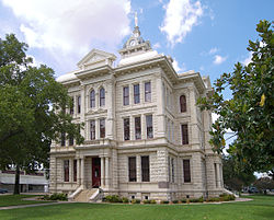 The Milam County Courthouse in Cameron. The Courthouse was added to the National Register of Historic Places on December 20, 1977.
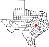
Location in the state of Texas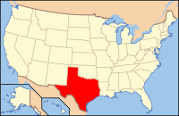
Texas's location in the U.S.Founded 1836 Seat Cameron Area
- Total
- Land
- Water
1,022 sq mi (2,647 km²)
1,017 sq mi (2,634 km²)
5 sq mi (13 km²), 0.48%Population
- (2000)
- Density
24,238
23/sq mi (9/km²)Website www.co.milam.tx.us 

Milam County is a county located in the U.S. state of Texas. In 2000, its population was 24,238. Milam County is named for Benjamin Rush Milam (pronounced "MY-lum"), an early settler and a soldier in the Texas Revolution. The seat of the county is Cameron[1].
Contents
Geography
According to the U.S. Census Bureau, the county has a total area of 1,022 square miles (2,646 km²), of which 1,017 square miles (2,633 km²) is land and 5 square miles (13 km²) (0.48%) is water.
Major highways
 U.S. Highway 77
 U.S. Highway 79
 U.S. Highway 190
 State Highway 36
Adjacent counties
- Falls County (north)
- Robertson County (northeast)
- Burleson County (southeast)
- Lee County (south)
- Williamson County (southwest)
- Bell County (northwest)
Demographics
As of the census[2] of 2000, there were 24,238 people, 9,199 households, and 6,595 families residing in the county. The population density was 24 people per square mile (9/km²). There were 10,866 housing units at an average density of 11 per square mile (4/km²). The racial makeup of the county was 78.89% White, 11.05% Black or African American, 0.50% Native American, 0.22% Asian, 0.01% Pacific Islander, 7.70% from other races, and 1.63% from two or more races. 18.63% of the population were Hispanic or Latino of any race. 16.7% were of American, 16.1% German, 7.2% English and 6.8% Irish ancestry according to Census 2000.
There were 9,199 households out of which 32.40% had children under the age of 18 living with them, 56.50% were married couples living together, 11.30% had a female householder with no husband present, and 28.30% were non-families. 25.90% of all households were made up of individuals and 14.10% had someone living alone who was 65 years of age or older. The average household size was 2.59 and the average family size was 3.11.
In the county, the population was spread out with 27.50% under the age of 18, 7.70% from 18 to 24, 24.70% from 25 to 44, 22.90% from 45 to 64, and 17.20% who were 65 years of age or older. The median age was 38 years. For every 100 females there were 96.10 males. For every 100 females age 18 and over, there were 90.60 males.
The median income for a household in the county was $33,186, and the median income for a family was $40,431. Males had a median income of $30,149 versus $20,594 for females. The per capita income for the county was $16,920. About 12.20% of families and 15.90% of the population were below the poverty line, including 21.80% of those under age 18 and 15.30% of those age 65 or over.
Cities and towns
- Ben Arnold (unincorporated)
- Buckholts
- Burlington (unincorporated)
- Cameron
- Davilla (unincorporated)
- Gause (unincorporated)
- Lilac (ghost town)
- Maysfield (unincorporated)
- Milano
- Nashville (ghost town)
- Rockdale
- San Gabriel (unincorporated)
- Sharp (unincorporated)
- Silver City (ghost town)
- Thorndale
- Tracy (ghost town)
Education
Six Independent School Districts (ISDs) are headquartered in Milam County:
- Buckholts Independent School District
- Cameron Independent School District
- Gause Independent School District
- Milano Independent School District
- Rockdale Independent School District
- Thorndale Independent School District.
Four additional districts extend into parts of Milam County, but are based in neighboring counties: Bartlett, Caldwell, Holland, and Rosebud-Lott.
St. Paul Lutheran School in Thorndale is a private institution that serves students in grades pre-kindergarten through eight.
See also
References
- ^ "Find a County". National Association of Counties. http://www.naco.org/Counties/Pages/FindACounty.aspx. Retrieved 2011-06-07.
- ^ "American FactFinder". United States Census Bureau. http://factfinder.census.gov. Retrieved 2008-01-31.
External links
- Milam County government website
- Informational website about the county
- Genealogical and Historical informational website about the county
- Milam County from the Handbook of Texas Online

Bell County Falls County Robertson County 
 Milam County, Texas

Williamson County Lee County Burleson County Municipalities and communities of Milam County, Texas Cities 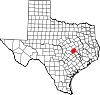
Town Unincorporated
communitiesBen Arnold | Branchville | Burlington | Davilla | Gause
Ghost towns Footnotes ‡This populated place also has portions in an adjacent county or counties
Categories:- Texas counties
- Milam County, Texas
- 1836 establishments in the United States
- Populated places established in 1836


Wikimedia Foundation. 2010.