- Midland County, Texas
-
Midland County, Texas 
Seal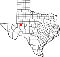
Location in the state of Texas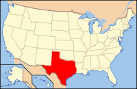
Texas's location in the U.S.Founded 1885 Seat Midland Area
- Total
- Land
- Water
902 sq mi (2,336 km²)
900 sq mi (2,331 km²)
2 sq mi (5 km²), 0.19%Population
- (2000)
- Density
116,009
129/sq mi (50/km²)Website www.co.midland.tx.us Midland County is a county located in the U.S. state of Texas. Midland is so named as the county is halfway (midway) between Fort Worth, Texas, and El Paso, Texas, on the Texas and Pacific Railway. The county seat is the city of Midland.[1] The population was 116,009 at the 2000 census.
Midland County is included in the Midland, Texas Metropolitan Statistical Area as well as the Midland–Odessa Combined Statistical Area.
Contents
Geography
According to the U.S. Census Bureau, the county has a total area of 902 square miles (2,336 km²), of which 900 square miles (2,332 km²) is land and 2 square miles (4 km²) (0.19%) is water. The Spraberry Trend, the third-largest oil field in the United States by remaining reserves, underlies much of the county.[2]
Major highways
 Interstate 20
 State Highway 349
 State Highway 158
Adjacent counties
- Martin County (north)
- Glasscock County (east)
- Upton County (south)
- Ector County (west)
- Andrews County (northwest)
Demographics
As of the census[3] of 2000, there were 116,009 people, 42,745 households, and 30,947 families residing in the county. The population density was 129 people per square mile (50/km²). There were 48,060 housing units at an average density of 53 per square mile (21/km²). The racial makeup of the county was 77.32% White, 6.98% Black or African American, 0.64% Native American, 0.93% Asian, 0.03% Pacific Islander, 12.17% from other races, and 1.92% from two or more races. 29.03% of the population were Hispanic or Latino of any race.
There were 42,745 households out of which 38.90% had children under the age of 18 living with them, 57.40% were married couples living together, 11.40% had a female householder with no husband present, and 27.60% were non-families. 24.20% of all households were made up of individuals and 8.60% had someone living alone who was 65 years of age or older. The average household size was 2.68 and the average family size was 3.21.
In the county, the population was spread out with 30.20% under the age of 18, 8.80% from 18 to 24, 28.40% from 25 to 44, 20.90% from 45 to 64, and 11.60% who were 65 years of age or older. The median age was 34 years. For every 100 females there were 93.40 males. For every 100 females age 18 and over, there were 89.40 males.
The median income for a household in the county was $39,082, and the median income for a family was $47,269. Males had a median income of $36,924 versus $24,708 for females. The per capita income for the county was $20,369. 12.90% of the population and 10.30% of families were below the poverty line. Out of the total people living in poverty, 16.20% are under the age of 18 and 7.90% are 65 or older.
Politics
Although Midland was historically Democratic, in recent years it has become heavily Republican. In Presidential elections the last Democratic candidate to win the county was Harry Truman in 1948.[4] It cast 36,135 votes for Republican John McCain for president which was 78% of the vote in Midland County. Democrat Barack Obama received 21% of the vote and 9,672 votes. Other candidates received 1% of the vote. Midland County is in the 11th Congressional District in Texas and it is represented by Mike Conaway, a Republican. The 11th Congressional District gave George W. Bush 78% of its votes in 2004, higher than any other congressional district in the nation. In Midland County in 2004, Republican George W. Bush received 82% of the vote in Midland County while Democrat John Kerry received 18%.
Cities and towns
- Greenwood (unincorporated)
- Midland (small portion in Martin County)
- Odessa (mostly in Ector County)
See also
References
- ^ "Find a County". National Association of Counties. http://www.naco.org/Counties/Pages/FindACounty.aspx. Retrieved 2011-06-07.
- ^ Top 100 Oil and Gas Fields
- ^ "American FactFinder". United States Census Bureau. http://factfinder.census.gov. Retrieved 2008-01-31.
- ^ Geographie Electorale
External links
- Midland County government's website
- Midland County from the Handbook of Texas Online

Andrews County Martin County Howard County Ector County 
Glasscock County  Midland County, Texas

Crane County Upton County Reagan County Municipalities and communities of Midland County, Texas Cities 
Unincorporated
communityFootnotes ‡This populated place also has portions in an adjacent county or counties
Categories:- Texas counties
- Midland County, Texas
- 1885 establishments


Wikimedia Foundation. 2010.