- Coombe Wood
-
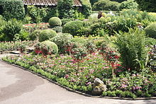 Flower Border in Coombe Wood Gardens
Coombe Wood is a small woodland and garden area in the old village of Coombe, Upper Shirley, in the London Borough of Croydon near the junction of Coombe Lane and Conduit Lane. The Coombe Wood Gardens are divided into a series of rooms which together give an all year round display of shrubs and plants set against a backdrop of mature woodland.
Contents
History
The area had been open over four hundred years ago when it was part of an estate (of Coombe House) with a large common field known as Coombe Field which stretched from Coombe Road to Park Hill. [1]
The common became the property of James Bourdieu Senior (of Coombe House) in 1801, at the time of the Inclosures of Common Land Act. Mr Bourdieu had already purchased The Coombe Estate, including Coombe Lodge, House and Farm which altogether amassed some 251 acres. Coombe Wood supplied water to the Coombe estate, via three conduits which ran along the adjacent lane hence the name 'Conduit Lane'.
In 1898, Arthur Lloyd, brother of Frank Lloyd built Coombe Wood House.
The estate of Coombe Wood House was later purchased for £14,000, with Coombe Wood, by Croydon Council, from Mr. W Cash (who was the Chairman of the Croydon Gas Company), for the use of the public of Croydon. The house was used as a convalescent and children's home. It has an area of 14 1/4 acres (5.67 hectares). The 14 acres of Parkland were opened to the public in 1948. With a café in the old stable block [1]
Access
It is served by Tramlink stops at Coombe Lane and Lloyd Park. The Vanguard Way (long distance footpath) also passes by the woods and garden.
Note: There are many other Coombe Woods all over the United Kingdom (including Benfleet, Essex).
See also
External links
References
Coordinates: 51°21′40″N 0°04′01″W / 51.361°N 0.067°W
Categories:- Parks and open spaces in Croydon
- London geography stubs


Wikimedia Foundation. 2010.