- Duval County, Texas
-
Duval County, Texas 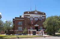 The Duval County Courthouse in San Diego.
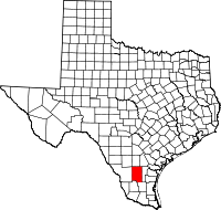
Location in the state of Texas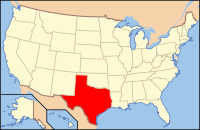
Texas's location in the U.S.Founded 1858 Seat San Diego Area
- Total
- Land
- Water
1,796 sq mi (4,652 km²)
1,793 sq mi (4,644 km²)
3 sq mi (8 km²), 0.17%Population
- (2000)
- Density
13,120
8/sq mi (3/km²)Duval County is a county located in the U.S. state of Texas. In 2000, its population was 13,120. It is named for Burr H. Duval, a soldier in the Texas Revolution who died in the Goliad Massacre. The seat of the county is San Diego[1]. It was founded in 1858.
Contents
Geography
According to the U.S. Census Bureau, the county has a total area of 1,796 square miles (4,651.6 km2), of which 1,793 square miles (4,643.8 km2) is land and 3 square miles (7.8 km2) (0.17%) is water.
Major highways
 U.S. Highway 59
 State Highway 16
 State Highway 44
 State Highway 339
 State Highway 359
Adjacent counties
- McMullen County (north)
- Live Oak County (northeast)
- Jim Wells County (east)
- Brooks County (southeast)
- Jim Hogg County (southwest)
- Webb County (west)
Demographics
As of the census[2] of 2000, there were 13,120 people, 4,350 households, and 3,266 families residing in the county. The population density was 7 people per square mile (3/km²). There were 5,543 housing units at an average density of 3 per square mile (1/km²). The racial makeup of the county was 80.22% White, 0.54% Black or African American, 0.53% Native American, 0.11% Asian, 0.03% Pacific Islander, 15.46% from other races, and 3.11% from two or more races. 87.99% of the population were Hispanic or Latino of any race.
There were 4,350 households out of which 36.80% had children under the age of 18 living with them, 53.20% were married couples living together, 16.80% had a female householder with no husband present, and 24.90% were non-families. 22.90% of all households were made up of individuals and 11.70% had someone living alone who was 65 years of age or older. The average household size was 2.88 and the average family size was 3.40.
In the county, the population was spread out with 29.50% under the age of 18, 9.50% from 18 to 24, 26.40% from 25 to 44, 20.60% from 45 to 64, and 14.00% who were 65 years of age or older. The median age was 34 years. For every 100 females there were 100.70 males. For every 100 females age 18 and over, there were 102.90 males.
The median income for a household in the county was $22,416, and the median income for a family was $26,014. Males had a median income of $25,601 versus $16,250 for females. The per capita income for the county was $11,324. About 23.00% of families and 27.20% of the population were below the poverty line, including 35.90% of those under age 18 and 25.30% of those age 65 or over.
Politics
Like much of heavily Hispanic South Texas, Duval County is a Democratic stronghold. The last Republican to carry the county was Theodore Roosevelt in 1904.[3] In the 1972 presidential election George McGovern received over 85% of the county's vote, which was the highest percentage of votes he received in any county nationally.[4] In the 2004 presidential election, it went solidly for Democrat John F. Kerry of Massachusetts, while George W. Bush carried the state as a whole by a wide margin. In the 2008 presidential election Barack Obama received 74.8% of the county's vote. In all the Democratic candidate has consistently received more than 70% of the county's vote since, at least, 1992.[5]
Duval County is historically notorious for corrupt politics, particularly during the mid-20th century, when it was largely controlled by the political machine headed by George Parr, known as the "Duke of Duval". The historian J. Evetts Haley ran for governor in 1956 with a threat that if elected he would "lock up" Parr. He finished a distant fourth in the primary balloting. Meanwhile, then state Attorney General John Ben Shepperd brought some three hundred state indictments against county and school officials.
Communities
Cities
Unincorporated areas
- Concepcion
- Ramirez
- Realitos
- Rios
- Sejita
References
- ^ "Find a County". National Association of Counties. http://www.naco.org/Counties/Pages/FindACounty.aspx. Retrieved 2011-06-07.
- ^ "American FactFinder". United States Census Bureau. http://factfinder.census.gov. Retrieved 2008-01-31.
- ^ Geographie Electorale
- ^ Statistics from David Leip's Atlas for 1972
- ^ The New York Times Electoral Map (Zoom in on Texas)
External links
- Duval County from the Handbook of Texas Online

McMullen County Live Oak County Webb County 
Jim Wells County  Duval County, Texas

Jim Hogg County Brooks County Municipalities and communities of Duval County, Texas County seat: San Diego Cities 
CDPs Unincorporated
communitiesGhost towns Crestonio | Pila Blanca | Sweden
Footnotes ‡This populated place also has portions in an adjacent county or counties
Categories:- Texas counties
- Duval County, Texas
- 1858 establishments in the United States
- Counties of the United States with Hispanic majority populations


Wikimedia Foundation. 2010.