- Denton County, Texas
-
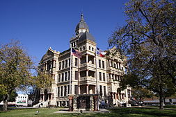
Denton County, Texas  The new Denton County Courthouse, built 1998
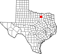
Location in the state of Texas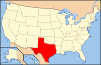
Texas's location in the U.S.Founded 1846 Seat Denton Area
- Total
- Land
- Water
958 sq mi (2,481 km²)
889 sq mi (2,302 km²)
69 sq mi (179 km²), 7.24%Population
- (2010)
- Density
662,614
745/sq mi (288/km²)Website www.co.denton.tx.us Denton County is a county located in the U.S. state of Texas. In 2000, its population was 432,976; in 2009 the estimated population had reached 628,300. Part of the Dallas – Fort Worth Metroplex, it is one of the fastest-growing counties in the United States. The county seat is Denton.[1] The county and the city are both named for John B. Denton, who was a preacher, lawyer, and soldier. It was founded in 1846.
Contents
Geography
According to the U.S. Census Bureau, the county has a total area of 958 square miles (2,481.2 km2), of which 889 square miles (2,302.5 km2) is land and 69 square miles (178.7 km2) (7.24%) is water.
Denton County sits atop a portion of the Barnett Shale, a geological formation believed to contain large quantities of natural gas. The County has benefited from tax revenue related to gas drilling and production, though complaints have arisen that many of the rural roads in the area (which were never designed to handle the heavy equipment used in gas drilling) have been destroyed by drilling companies[citation needed].
Major highways
 Interstate 35
- President George Bush Turnpike
 U.S. Highway 77
 U.S. Highway 377
 U.S. Highway 380
 State Highway 114
 State Highway 121
 Loop 288
Adjacent counties
- Cooke County (north)
- Grayson County (northeast)
- Collin County (east)
- Dallas County (southeast)
- Tarrant County (south)
- Wise County (west)
Demographics
 The former Denton County Courthouse, resting place of the county's (and city's) namesake, was listed in the NRHP in 1977. The surrounding buildings on the square were listed on December 28, 2000
As of the census[2] of 2000, there were 432,976 people, 158,903 households, and 111,391 families residing in the county. The population density was 487 people per square mile (188/km²). There were 168,069 housing units at an average density of 189 per square mile (73/km²). The racial makeup of the county was 81.73% White, 5.86% Black or African American, 0.59% Native American, 4.03% Asian, 0.05% Pacific Islander, 5.56% from other races, and 2.19% from two or more races. 12.15% of the population were Hispanic or Latino of any race.
There were 158,903 households out of which 39.10% had children under the age of 18 living with them, 57.90% were married couples living together, 8.60% had a female householder with no husband present, and 29.90% were non-families. 22.20% of all households were made up of individuals and 3.20% had someone living alone who was 65 years of age or older. The average household size was 2.67 and the average family size was 3.18.
In the county, the population was spread out with 27.70% under the age of 18, 11.30% from 18 to 24, 37.00% from 25 to 44, 19.00% from 45 to 64, and 5.00% who were 65 years of age or older. The median age was 31 years. For every 100 females there were 99.00 males. For every 100 females age 18 and over, there were 96.60 males.
The median income for a household in the county was $58,216, and the median income for a family was $69,292 (these figures had risen to $68,624 and $83,477 respectively as of a 2007 estimate[3]). Males had a median income of $45,835 versus $31,639 for females. The per capita income for the county was $26,895. About 4.10% of families and 6.60% of the population were below the poverty line, including 6.20% of those under age 18 and 7.10% of those age 65 or over.'
Denton County ranked twenty-ninth on the US Census Bureau's list of fastest growing counties between 2000 and 2007, with a 41.4% increase in population.[4] Denton County along with other Texas Counties has one of the nation's highest property tax rates. In 2007, it was #26 for property taxes as percentage of the homes value on owner occupied housing.[5]
Cities and towns
Historical populations Census Pop. %± 1850 641 — 1860 5,031 684.9% 1870 7,251 44.1% 1880 18,143 150.2% 1890 21,289 17.3% 1900 28,318 33.0% 1910 31,258 10.4% 1920 35,355 13.1% 1930 32,822 −7.2% 1940 33,658 2.5% 1950 41,365 22.9% 1960 47,432 14.7% 1970 75,633 59.5% 1980 143,126 89.2% 1990 273,525 91.1% 2000 432,976 58.3% 2010 662,614 53.0% † only a small part of the city extends into Denton County
Education
The following school districts lie entirely within Denton County:
- Argyle Independent School District
- Aubrey Independent School District
- Denton Independent School District
- Lake Dallas Independent School District
- Lewisville Independent School District
- Little Elm Independent School District
- Ponder Independent School District
- Sanger Independent School District
while parts of the following districts fall within the county:
- Carrollton-Farmers Branch Independent School District (very small part only)
- Celina Independent School District (very small part only)
- Era Independent School District (very small part only)
- Frisco Independent School District
- Krum Independent School District
- Northwest Independent School District
- Pilot Point Independent School District
- Prosper Independent School District (very small part only)
- Slidell Independent School District
The following colleges serve Denton County:
In popular culture
- Denton County is referenced in Bowling for Soup's single, "Ohio (Come Back to Texas)".
- Contrary to popular belief, The City of Denton, TX is not where Brad proposes to Janet in "The Rocky Horror Picture Show"; the movie takes place in fictional Denton, OH (http://www.imdb.com/title/tt0073629/plotsummary). For a brief time in the early 1990s, a billboard mimicking the "The Home of Happiness" billboard in the first scene of the movie in the churchyard was in place along I-35 north of the city that said the same thing, erected each year before Halloween.
- The Mountain Goats 2000 record All Hail West Texas opens with the song "The Best Ever Death Metal Band in Denton".
See also
References
- ^ "Find a County". National Association of Counties. http://www.naco.org/Counties/Pages/FindACounty.aspx. Retrieved 2011-06-07.
- ^ "American FactFinder". United States Census Bureau. http://factfinder.census.gov. Retrieved 2008-01-31.
- ^ "Denton County, Texas - Fact Sheet - American FactFinder". Factfinder.census.gov. http://factfinder.census.gov/servlet/ACSSAFFFacts?_event=Search&geo_id=05000US33015&_geoContext=01000US%7C04000US33%7C05000US33015&_street=&_county=denton+county&_cityTown=denton+county&_state=04000US48&_zip=&_lang=en&_sse=on&ActiveGeoDiv=geoSelect&_useEV=&pctxt=fph&pgsl=050&_submenuId=factsheet_1&ds_name=ACS_2007_3YR_SAFF&_ci_nbr=null&qr_name=null®=null%3Anull&_keyword=&_industry=. Retrieved 2010-07-22.
- ^ "Table 8: Population Estimates for the 100 Fastest Growing U.S. Counties with 10,000 or More Population in 2007: April 1, 2000 to July 1, 2007". U.S. Census Bureau. http://www.census.gov/popest/counties/tables/CO-EST2007-08.xls. Retrieved 2008-07-15.
- ^ http://www.taxfoundation.org/research/show/1888.html Taxfoundation.org
- ^ Census population counts for Counties, 1850-1890
External links
- Denton County government's website
- Headlines about Denton County from The Dallas Morning News
- Denton County entry in the Handbook of Texas Online at the University of Texas
- Denton County Texas Almanac Page
- Historic Denton County materials, hosted by the Portal to Texas History.
- Captain John B. Denton, preacher, lawyer and soldier. His life and times in Tennessee, Arkansas and Texas by Wm. Allen., published 1905, hosted by the Portal to Texas History
- A Guide to Things to Do and See in Denton County
- Denton County on DentonWiki

Cooke County Grayson County Wise County 
Collin County  Denton County, Texas

Tarrant County Dallas County Municipalities and communities of Denton County, Texas Cities Argyle | Aubrey | Carrollton‡ | Celina‡ | Coppell‡ | Corinth | Dallas‡ | Denton | Fort Worth‡ | Frisco‡ | Grapevine‡ | Haslet‡ | Highland Village | Justin | Krugerville | Krum | Lake Dallas | Lakewood Village | Lewisville‡ | Oak Point | Pilot Point | Plano‡ | Roanoke | Sanger | Southlake‡ | The Colony

Towns Bartonville | Copper Canyon | Corral City | Cross Roads | DISH | Double Oak | Flower Mound‡ | Hackberry | Hebron‡ | Hickory Creek | Lincoln Park | Little Elm | Northlake | Ponder | Prosper‡ | Providence Village | Shady Shores | Trophy Club‡ | Westlake‡
Unincorporated
communitiesAlliance‡ | Bolivar | Lantana | Navo | Paloma Creek | Savannah
Ghost towns Alton | Elizabethtown | Mustang
Footnotes ‡This populated place also has portions in an adjacent county or counties
Dallas–Fort Worth–Arlington Counties Major cities Cities and towns
100k-300kCarrollton • Denton • Frisco • Garland • Grand Prairie • Irving • McKinney • Mesquite • Plano • RichardsonCities and towns
25k-99kAllen • Bedford • Cedar Hill • Cleburne • The Colony • Coppell • DeSoto • Duncanville • Euless • Farmers Branch • Flower Mound • Grapevine • Haltom City • Highland Village • Hurst • Keller • Lancaster • Lewisville • Mansfield • North Richland Hills • Rockwall • Rowlett • WylieCities and towns
10k-25kAddison • Balch Springs • Benbrook • Burleson • Colleyville • Corinth • Ennis • Forest Hill • Greenville • Saginaw • Seagoville • Southlake • Terrell • University Park • Watauga • Waxahachie • Weatherford • White SettlementCategories:- Texas counties
- Dallas – Fort Worth Metroplex
- Denton County, Texas
- 1846 establishments in the United States


Wikimedia Foundation. 2010.