- Østhorn (station)
-
Østhorn 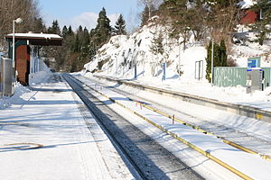
Location Place Nordberg Municipality Oslo Coordinates 59°57′21″N 10°45′4″E / 59.95583°N 10.75111°ECoordinates: 59°57′21″N 10°45′4″E / 59.95583°N 10.75111°E Line Sognsvann Line Distance 7.1 kilometres (4.4 mi) Service Opened 10 October 1934 Type At-grade Line(s) 
Connections Østhorn (until 1939 Korsvoll) is a station on the Sognsvann Line (line 3) of the Oslo Metro in Norway. It is located 7.1 kilometres (4.4 mi) from Stortinget station between Tåsen and Holstein stations. As one of the original stations on the line, Østhorn was opened on 10 October 1934. Nordberg was formerly the next northbound station, but it was closed in 1992, when the Sognsvann Line was upgraded to metro standard. Østhorn is located near a hill named Havnabakken, where local residents toboggan at winter's time.
Contents
History
Korsvoll station opened on 10 October 1930, when Akersbanerne had finished the Songsvann Line from Majorstuen to Sognsvann station.[1] The line was double-tracked from Majorstuen to Korsvoll, and single-tracked from there to Sognsvann.[2] In 1939, the section Korsvoll–Sognsvann was upgraded to double tracks, and the station Korsvoll had its name changed to Østhorn.[1] The name "Østhorn" owes its origins to a crag by the same name that was demolished during the construction of the Sognsvann Line.[3] The station is now positioned inside the remains of the crag, with metal nest put up to prevent any crumbling of the surrounding crag.
Østhorn was part of Holmenkolbanen's operating network until 1975, when the municipality of Oslo bought all the company's stock.[4] In 1993, the stations on the Sognsvann Line were upgraded to metro standard, which involves a heightening and lengthening of the platforms, and installation of third rail power supply and a new signaling system. During the upgrade, Tåsen station was moved 150 metres (490 ft) further north,[3] and Nordberg station was closed.[5] Many local residents opposed the new station upgrades, arguing that Nordberg had served the area well with its close connection to the elderly center Nordberghjemmet.[6] Many wanted to rather close Østhorn or Holstein than Nordberg, since the latter was the most used station in the area.[6] Oslo Sporveier stated that the access roads to Nordberg were very steep and dangerous,[7] and referred to a case in the 1950s where some local youth had been tobogganing over the rail intersection at Nordberg, and hit a truck near the station.[8] They also argued that the 200 metres (660 ft) distance between Nordberg and Holstein was too close for having two stations, and promised to build a one-way walkway from Nordberg to Holstein.[9]
Service
Østhorn is served by the line 3 on the Sognsvann Line, operated by Oslo T-banedrift on contract with Ruter. The rapid transit serves the station every 15 minutes, except in the late evening and on weekend mornings, when there is a 30-minute headway.[10] Travel time along the 7.1-kilometre (4.4 mi) portion to Stortinget in the city center is 13 minutes.[11]
The station provides correspondence to the bus lines 22 and 25 on the top of Havnabakken, a five minute walk away.[12]
Facilities
Østhorn has two platforms, each with a wooden shed.[13] The sheds are designed by Arne Henriksen in a minimalist and standardised style with constructions of wood and steel.[14][15] Østhorn serves the residential areas Korsvoll and Nordberg.[16][17] The station is located at the bottom of a small hill named Havnabakken, where local residents toboggan at winter's time.[18][19]
References
- Notes
- ^ a b Nilsen 1998, p. 133
- ^ Arntzen & Hansen 2009, p. 88
- ^ a b Hegna, Liv (5 January 2004). "Østhorn: Oppkalt etter knaus som ikke finnes" (in Norwegian). Aftenposten Aften: p. 40.
- ^ Nilsen 1998, p. 140
- ^ "Sognsvannsbanen modernisert" (in Norwegian). Aftenposten Aften: p. 8. 8 January 1993.
- ^ a b Hoel, Erik (6 January 1993). "Sognsvannsbanen Ny, dyr og dårlig" (in Norwegian). Aftenposten Aften: p. 54.
- ^ Hammersmark, Marit (22 January 1993). "Sognsvannsbanen Sikkerheten først" (in Norwegian). Aftenposten Aften: p. 54.
- ^ "Farlig leketøy" (in Norwegian). Verdens Gang: p. 6. 2 March 1951.
- ^ Hammersmark, Marit (26 November 1990). "Pendeldrift - et tilbud for de få?" (in Norwegian). Aftenposten Aften: p. 8.
- ^ Ruter (18 August 2008). "Rutetider T-banen" (in Norwegian) (PDF). http://www1.trafikanten.no/trafikkinfo/tabeller/os/080818_T-bane.pdf. Retrieved 30 October 2010.
- ^ Ruter. "Rutetabeller T-banens linjer 2-6 og buss 1B, 1C, 1D" (in Norwegian) (PDF). pp. 19–22. http://trafikanten.no/Gallery/1-GalleryRot/24-Rutetabeller/25-2010/26-Oslo/T-banen%20h101.pdf. Retrieved 30 October 2010.
- ^ Ruter (2007). "Linjekart for busslinjene i Oslo Nord" (in Norwegian). http://ruter.no/PageFiles/2519/Bybuss2009-04NordPRESS.pdf. Retrieved 6 November 2009.
- ^ "Hallo Oslo" (in Norwegian). Aftenposten Aften: p. 2. 29 October 1985.
- ^ Hartmann & Mangset 2001, p. 39
- ^ "Sognsvannsbanen blir T-bane" (in Norwegian). Lokaltrafikk 15: 22–23. 1992.
- ^ Tvedt, Knut Are (2007). "Korsvoll". In Henriksen, Petter (in Norwegian). Store norske leksikon. Oslo: Kunnskapsforlaget. http://snl.no/Korsvoll. Retrieved 2 November 2010.
- ^ Tvedt, Knut Are (2007). "Nordberg". In Henriksen, Petter (in Norwegian). Store norske leksikon. Oslo: Kunnskapsforlaget. http://snl.no/Nordberg. Retrieved 2 November 2010.
- ^ Endresen, Kristoffer Hatteland (25 February 2009). "Mei din vei!" (in Norwegian). Aftenposten Aften: p. 20.
- ^ "Vilter vinterferie" (in Norwegian). Dagsavisen: p. 45. 20 February 2010.
- Bibliography
- Andersen, Bjørn (1993) (in Norwegian). Holmenkollbanen: Kort historikk fra 1898 til 1993. Oslo: Lokaltrafikkhistorisk forening. ISBN 82-91223-01-7.
- Arntzen, Jon G.; Hansen, Stig A. (2009) (in Norwegian). OSLO 1925–45. Oslo: Kom forlag. ISBN 978-82-92496-800.
- Aspenberg, Nils Carl (1995) (in Norwegian). Neste stopp Makrellbakken: Historien om Røabanen. Oslo: Baneforlaget. ISBN 82-91448-18-3.
- Hartmann, Eivind; Mangset, Øistein (2001) (in Norwegian). Neste Stopp! : Verneplan for bygninger. Oslo: Baneforlaget. ISBN 82-91448-17-5.
- Nilsen, Knut A. (1998) (in Norwegian). Nordmarkstrikken: Holmenkollbanen gjennom 100 år. Oslo: Aschehoug. ISBN 82-03-22262-3.
External links
TERMINUS NEXT STATION
← WESTØsthorn NEXT STATION
EAST→TERMINUS Sognsvann Holstein Line 3 Tåsen Mortensrud Categories:- Oslo Metro stations in Oslo
- Railway stations opened in 1934
- 1934 establishments in Norway

Wikimedia Foundation. 2010.