- Cessnock, New South Wales
-
Cessnock
New South Wales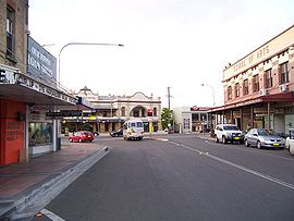
Cessnock, New South Wales
 Cessnock
Population: 18,316[1] Note1 Postcode: 2325 Coordinates: 32°50′3″S 151°21′19.8″E / 32.83417°S 151.3555°ECoordinates: 32°50′3″S 151°21′19.8″E / 32.83417°S 151.3555°E Elevation: 80 m (262 ft) Time zone: • Summer (DST)
AEST (UTC+10) AEDT (UTC+11)
Location: LGA: Cessnock City Council Region: Hunter County: Northumberland Parish: Cessnock State District: Federal Division: Hunter Mean max temp Mean min temp Annual rainfall 24.6 °C
76 °F11.1 °C
52 °F747.5 mm
29.4 in Aerial photo of countryside around Cessnock
Cessnock is a city in the Hunter Region of New South Wales, Australia, about 52 km (32 mi) by road west of Newcastle. It is the administrative centre of the Cessnock City Council LGA and was named after an 1826 grant of land called Cessnock Estate, which was owned by John Campbell.[2][3] The local area once known as "The Coalfields" is now the gateway city to the vineyards of the Hunter Valley, which includes Pokolbin, Mount View, Broke, Rothbury, and Branxton.
Contents
Geography
The town is located in the rich alluvial and volcanic soils of the Hunter Valley. Rich coal seams underlie much of the area. The Brokenback Range (part of the Great Dividing Range) rises to the west of the city. The Hunter River flows down the Hunter Valley approximately 20 km (12 mi) to the north. Cessnock lies within the Hunter Valley Important Bird Area.[4]
History
The transition to wine service centre from a once prosperous mining town has been a long and at times difficult process.
Cessnock lies between Australia’s earliest European settlements - Sydney, the Hawkesbury River and Newcastle. Lying on the land route between these important settlements it provided early European contact with indigenous people who have inhabited the Cessnock area for more than 3,000 years. The Darkinjung people were the major inhabitants at the time of European contact, which subsequently proved to be disastrous for the Darkinjung tribe. Many were killed or died as a result of European diseases. Others were forced onto neighbouring tribal territory and killed. The city of Cessnock abounds in indigenous place names and names with indigenous association which is indicative of this settlement and include Congewai, Kurri Kurri, Laguna, Nulkaba and Wollombi.
Pastoralists commenced settling the land in the 1820s. Cessnock was named by Scottish settler John Campbell, after his grandfather's baronial Cessnock Castle in Ayrshire to reflect the aristocratic heritage and ambitions for this estate.[2][3] The township of Cessnock developed from 1850, as a service centre at the junction of the Great North Road from Sydney to the Hunter Valley, with branches to Maitland and Singleton. During the 1860s, land settlement was extensive between Nulkaba and Pokolbin, with wheat, tobacco and grapes the principal crops.[citation needed]
The establishment of the South Maitland coalfields generated extensive land settlement between 1903 and 1923. The current pattern of urban development, transport routes and industrial landscape was laid at this time. The surveying of the Greta coal seam by Professor Edgeworth David around 1888 became the impetus for considerable social and economic change in the area with the development of the coal mining industry.
Whilst mining was the principal industrial base and source of employment in the Cessnock area for the first half of the 20th century, a slump which commenced about 1960 forced the closure of many mines. Subsequent changes to the mining industry, including automation and the introduction of sophisticated computerised equipment, led to the closure of the vast majority of the remaining mines in the area. This has resulted in a decline in population in many villages and townships over the last twenty years which has led to the closure of some schools, shops and community meeting places. Consequently, many areas have undergone a change in character, with rural residential housing developments becoming popular, as well as small cottages and farms used principally as weekend retreats.[citation needed]
Economy
The decline of mining on the South Maitland Coalfields has been paralleled by growth in the wine industry and better access to other employment centres.
The Hunter Valley wine-growing area near Cessnock is Australia's oldest wine region and one of the most famous, with around 1,800 hectares (4,448 acres) under vine. The vineyards of Pokolbin, Mount View and Allandale, with their rich volcanic soils tended by entrepreneurial vignerons, are also the focus of a thriving and growing tourism industry. The extension and eventual completion of the F3 Freeway, created a property and tourism boom during the 1990s.
Cessnock has begun to develop other tourist ventures beyond the wine industry such as championship golf courses, hot air ballooning, sky-diving, and guest house accommodation.
The city council has actively pursued a policy of urban renewal in the city centre since 2001. The local council was one of the first to introduce a recycling program for waste disposal in the state.
Most employment comes from the local port city of Newcastle, the nearby major centres of Maitland and Singleton and in service industries in the local council area, which comprises many small towns, such as Kurri Kurri, Weston, Neath, Abernethy, Kearsley and Pokolbin.
-

Caledonia Hotel, Aberdare Road
-

Cessnock Court House, Maitland Road (designed by George McRae, Government Architect)
-

St John's Church, Dudley Street
-

Weatherboard cottages, Dudley Street
-

Rodeo at Cessnock showground
Education
- Primary schools
- Cessnock Public School
- Nulkaba Public School
- Cessnock East Public School
- Bellbird Public School
- Cessnock West Public School
- Kearsley Public School
- St Patricks Primary
- High schools
- Cessnock High School
- Mount View High School
- St Phillips Christian College
Cessnock also has a TAFE institution for further education.
Sport
The city has many sporting facilities. The city competes in several regional sporting competitions, particularly the Newcastle-based leagues of various sports. Some very successful sporting players can trace their roots to the local district, including Australian Rugby League representative players and brothers Andrew and Matthew Johns. World-renowned golfer and TV commentator Jack Newton is also from Cessnock. His annual Sub-Juniors Golf Tournament has unearthed some talented young golfers and is held on the local championship courses of Pokolbin.
Transport
For a century Cessnock was served by a very extensive railway network, originally constructed for the coal industry, but which, at one time, had considerable passenger services, including a direct train to Sydney. Whilst the railway remains open for coal trains from the last coal mine, the passenger services were ceased in 1972.[citation needed]
The Sydney-Newcastle Freeway's Cessnock exit at Freemans Waterhole provides one of the main road connections from Sydney to Cessnock via "The Gap", a pass through the Wattagan mountain range just north of Mt Heaton. A new freeway linking the New England Highway at Branxton and the Sydney-Newcastle Freeway at West Wallsend is planned to be built in the near future, which will bypass Cessnock. Less traffic will take pressure off the local roads and provide easier access to Pokolbin from Sydney and Newcastle.[citation needed]
The local airport is placed just to the north of the city, at the entrance to the Vineyard District. It has a small public passenger terminal and also serves as the base for aviation training organisations such as Avondale College's school of Aviation and Hunter Valley Aviation. The airport is not served by RPT flights. Access by air to the region is by Newcastle Airport at Williamtown, 53 km (33 mi) away.
The local bus service is run by Rover Motors which provide services to Maitland, Newcastle and Sydney as well as local school bus services.
Notable people from Cessnock
- Andrew and Matthew Johns—Rugby League players
- Joel Edwards, Newcastle Knights player
- Douglas N. Daft—businessman; CEO of Coca-Cola (2000–04), Corporate Director of Wal-Mart
- Kenneth Neate, opera singer
- Gavin King, journalist; newspaper columnist
- Simon Whitlock, Professional Darts Player
National Estate
Greater Cessnock contains a number of buildings and sites that are on the Register of the National Estate.[5]
- Court House, Branxton
- Police Station and Residence, Branxton
- Former Court House, Greta
- Kurri Kurri Hotel, Lang and Hampden Streets, Kurri Kurri
- Richmond Main Colliery, Mulbring Rd, Pelaw Main
- Laguna House, Laguna
- Post Office, Wollombi
- Endeavour Museum (former Court House), Wollombi
- Public School, Wollombi
- St Michael's Catholic Church, Wollombi
- St John the Evangelist Anglican Church, Wollombi
- Stanford Main No.2 Colliery Pit Head Building, Brick Cottages
- Aboriginal Rock Carvings Site, popularly known as Baiame Cave, Milbrodale Area
See also
Notes
- ^ This is based on the population for the Cessnock-Bellbird urban centre, a statistical area used by the Australian Bureau of Statistics which is slightly different to the actual town of Cessnock.
References
- ^ Australian Bureau of Statistics (25 October 2007). "Cessnock-Bellbird (Urban Centre/Locality)". 2006 Census QuickStats. http://www.censusdata.abs.gov.au/ABSNavigation/prenav/LocationSearch?collection=Census&period=2006&areacode=UCL118400&producttype=QuickStats&breadcrumb=PL&action=401. Retrieved 2008-05-16. Map
- ^ a b "Cessnock". Geographical Names Register. Geographical Names Board of New South Wales. http://www.gnb.nsw.gov.au/name_search/extract?id=JPKqZxKmTR. Retrieved 2008-05-16.
- ^ a b "Cessnock is the eastern gateway to New South Wales". Hunter Vineyard Tours. http://www.huntervineyardtours.com.au/cessnock.htm. Retrieved 2008-05-16.
- ^ BirdLife International. (2011). Important Bird Areas factsheet: Hunter Valley. Downloaded from http://www.birdlife.org on 2011-07-11.
- ^ The Heritage of Australia, Macmillan Company, 1981
- "Cessnock Post Office". Climate statistics for Australian locations. Bureau of Meteorology. http://www.bom.gov.au/climate/averages/tables/cw_061009.shtml. Retrieved 2008-06-02.
Towns, suburbs and localities of the City of Cessnock | Hunter Region | New South Wales Towns, suburbs
& localitiesAberdare • Aberdare West • Abermain • Abernethy • Allandale • Anvil Creek • Bellbird • Bellbird Heights • Big Yengo • Bishops Bridge • Black Hill • Blaxlands Arm • Boree • Branxton • Brunkerville • Buchanan • Buttai • Campbell • Cedar Creek • Central Wattagan • Cessnock • Cessnock North • Cessnock South • Cessnock West • Cliftleigh • Congewai • Crawfordville • East Branxton • East Cessnock • Eglinford • Ellalong • Elrington • Greta • Greta Main • Heaton • Heddon Greta • Kearsley • Keinbah • Kitchener • Kurri Kurri • Kurri Kurri North • Kurri Kurri West • Laguna • Little Wallabadah • Lovedale • Loxford • Millfield • Mootai • Moruben • Mount View • Mount Vincent • Mulbring • Murrays Run • Narone Creek • Neath • North Rothbury • Nulkaba • Paxton • Paynes Crossing • Pelaw Main • Pelton • Pokolbin • Quorrobolong • Richmond Main • Richmond Vale • Rothbury • Sawyers Gully • South Weston • Spion Kop • Stanford Merthyr • Stockrington • Sweetmans Creek • Tomalpin • Watagan • Watagan Central • Watagan Forest • Weston • Wollombi • Yallambie • Yango • Yango Creek
Other places &
points of interestCessnock Airport • Hunter Valley Railway Trust • Huntlee (proposed town) • Mount Sugarloaf • Richmond Vale Railway • Watagans National Park • Werakata National Park
Cities of Australia Australian Capital Territory Canberra (national capital)New South Wales Albury · Armidale · Bathurst · Broken Hill · Cessnock · Coffs Harbour · Dubbo · Gosford · Goulburn · Grafton · Griffith · Lake Macquarie · Lismore · Lithgow · Maitland · Newcastle · Nowra · Orange · Queanbeyan · Sydney · Tamworth · Wagga Wagga · WollongongNorthern Territory Queensland Brisbane · Bundaberg · Cairns · Caloundra · Gladstone · Gold Coast · Gympie · Hervey Bay · Mackay · Maryborough · Mount Isa · Rockhampton · Sunshine Coast · Toowoomba · TownsvilleSouth Australia Adelaide · Mount Gambier · Murray Bridge · Port Augusta · Port Lincoln · Port Pirie · Victor Harbor · WhyallaTasmania Victoria Western Australia Categories:- Towns in New South Wales
- Cities in New South Wales
- Suburbs of the Hunter Region, New South Wales
- Towns in the Hunter Region, New South Wales
-


Wikimedia Foundation. 2010.