- Transport in Manchester
-
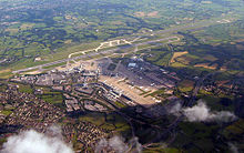 Manchester Airport is the busiest airport outside the London region
 The Wilmslow Road bus corridor is believed to be one of the busiest bus corridors in Europe
The transport infrastructure of Manchester is built up of numerous transport modes and forms an integral part of the structure Greater Manchester and North West England. Its position as a national city of commerce, education and cultural importance means the city has one of the largest and most thorough transport infrastructures which is heavily relied upon by its 2.5 million inhabitants in the Greater Manchester conurbation and further afield in the North West region.
Greater Manchester has a higher percentage of the motorway network than any other county.[1] According to the Guinness Book of World Records, it has the most traffic lanes side by side (17), spread across several parallel carriageways - the M61 at Linnyshaw Moss, Greater Manchester,[2] close to the M60 interchange (the M60 is one of only two motorways in the UK designated as an 'Orbital Motorway, (the other being the M25 around London).
Greater Manchester still has an extensive citywide railway network , two mainline termini (Victoria and Piccadilly) and four through mainline railway stations in the central area (Deansgate, Salford Central, Salford Crescent and Oxford Road). Rail use by passengers in Greater Manchester has nearly doubled in the ten years from 2001 to 2011 and is predicted it will rise by a further 54% from 2011 to 2020.[3]
It was the first city in the United Kingdom to re-introduce trams to the streets with the 1992 opening of Manchester Metrolink, which is currently undergoing a major revamp and by 2015 the system will be the largest in the UK[4] with at least 99 stops (72 more than in 2010) with 4 new lines currently being constructed and another line to the Trafford Centre envisaged.[5]
Manchester Airport is the busiest airport outside the London region and has double the annual passenger figures of its nearest rival, making the airport the fourth busiest overall in the United Kingdom. The city also has an extensive network of canal systems which converge into Manchester. The Manchester Ship Canal, built in 1894, is by far the largest canal and remains the 8th largest ship canal in the world.
Contents
Air - Manchester Airport
See also: Manchester Airport and City Airport Manchester Terminal 2 at Manchester Airport
Manchester Airport, formerly Manchester (Ringway) Airport, is the fourth busiest airport in the UK in terms of passengers per year (the busier airports are London's Heathrow, Gatwick and (from 2006) Stansted). It is served by a dedicated railway station. In 2008 the airport handled 21.06 million passengers and provided direct flights to over 200 destinations worldwide by over 90 airlines from three terminals. Long haul scheduled destinations served directly include New York ( JFK and Newark), Chicago, Boston, Philadelphia, Atlanta, Orlando, Toronto, Calgary, Vancouver, Port of Spain, Antigua, Barbados, St. Lucia and Cancún. Asian destinations include Damascus, Dubai, Abu Dhabi, Doha, Jeddah, Riyadh, Karachi, Islamabad, Lahore and Singapore. There are also firm plans for direct services to Beijing, Bangkok and Hong Kong. Many European and domestic destinations are served. Manchester to London is one of the highest density airline routes within the UK and is one of the busiest domestic sectors in Europe, but is now experiencing serious competition from the improved railway link.
The airport has been voted the best airport in the UK by Which? consumer magazine, Travel Weekly Globe, Business Magazines International for the second year running[citation needed] and in the Airport World's Service Excellence Awards[citation needed] (European runner up, second only to Copenhagen).
Road
See also: Manchester Congestion Charge A view of the Mancunian Way elevated motorway which cuts through the city centre.
Greater Manchester and Greater London are the only two UK conurbations with a separately numbered orbital motorway (though it is possible to circumnavigate Birmingham via several differently numbered motorways). The Manchester ring road is called the M60. Unlike London's M25, the M60 actually runs within the Greater Manchester conurbation providing good inter-suburban links, rather than around the outside of the conurbation. The M60 has 27 junctions, numbered clockwise from Junction 1 at Stockport in the south-east.
The M60 between junction 16 (Pendlebury/Kearsley) and junction 17 (Prestwich/Whitefield) is the second busiest section of road in the UK, after the M25 at junctions 13 & 14 (Heathrow). Research in 2008 suggested that Manchester is the fourth most congested city in Europe.[6] In 2010, it was decided that ramp metering would be used at numerous junctions on the M60 in an attempt to cut queues.[7]
The city also has an inner ring road. Part of this is the A57/A57(M) (known as Mancunian Way), which runs south of the city centre, linking the western M602 (which spurs from the M60) to the eastern M60 and M67.
The other main motorways serving Manchester are the M56 (to the airport, Chester and the M6 southbound to Birmingham), the M61 (to Bolton, Preston and the M6 northbound to Wigan and Lancaster), the M62 (west to Liverpool and east to Leeds and Kingston upon Hull), the M66 (to Bury) and the M67, which was originally planned as a route to Sheffield but never completed. All of these motorways connect with the M60.
Rail
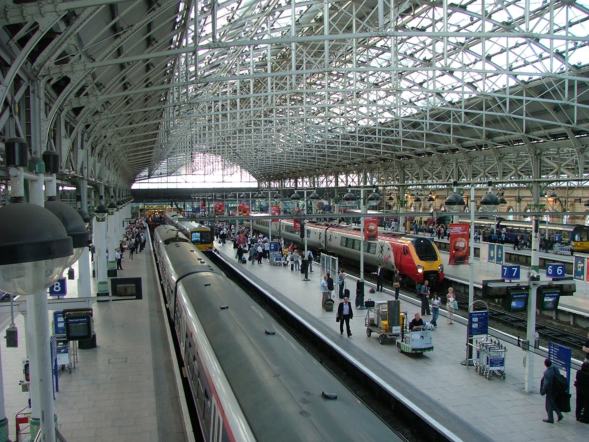
Main article: List of railway stations in Greater Manchester A view from inside Manchester's busiest railway station, Piccadilly.
Manchester holds a pivotal position in railway history as a birthplace of passenger rail travel on the Liverpool and Manchester Railway, which opened in 1830. Railway links to London were established by 1842. In just 50 years the city centre was encircled by stations and termini, including Manchester London Road (now Manchester Piccadilly), Manchester Victoria, Manchester Central, Manchester Mayfield and Manchester Exchange. Cutbacks followed the Beeching Report in the 1960s, with Manchester Central, Manchester Mayfield and Manchester Exchange closing to passengers. All rail services were then concentrated on Manchester Victoria and Manchester Piccadilly.
Manchester Piccadilly was the busiest railway station in England outside London in terms of passengers in 2005–2006.[8]
High speed trains to London are run from Manchester Piccadilly by Virgin Trains, journeys typically taking around 2 hr 07 min, with the fastest taking 1 hr 58 mins.
 Manchester Victoria Station, the less busy of the two in Manchester city centre
There are several smaller stations around the city centre, including Oxford Road and Deansgate (formerly Knott Mill), and Salford Central across the Irwell in the City of Salford.
There is no underground railway system similar to Glasgow's, London's or Liverpool's although the city has had several failed attempts to create one, including the "Picc-Vic tunnel", a heavy rail tunnel to link the main stations. Excavation work under the Manchester Arndale for this project began in the 1970s, but was soon abandoned due to costs and rumours of 'subterranean obstacles'. This may well have referred to the 'Guardian' underground nuclear bunker network, constructed as a means of protecting communications in the city in the event of an atom bomb being deployed and now used by BT. Other abandoned tunnels hidden for decades have recently been discovered including a 460-metre canal tunnel from the River Irwell to the canal system '[9]' '[10]'.
Piccadilly and Victoria are now linked by the city's Metrolink tram system.
The urban and suburban areas are covered by a sizeable network of railway lines, including to Ashton-under-Lyne, Bolton, Stockport and Wigan. Full timetables are from National Rail Enquiries. The commuter rail network within Greater Manchester (which numbers 101 stations) is the most extensive outside Greater London and the South East.[11]
Tram - Manchester Metrolink
Main article: Manchester Metrolink
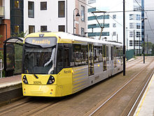 A new yellow Metrolink tram introduced in 2009
Manchester has a tram system called Metrolink. Operated by Stagecoach, Metrolink links the city centre to Altrincham, Eccles and Bury. It is a high-frequency service, with trams running every 6–12 minutes. It carries nearly 20 million passengers each year.
Trams first appeared on the streets of Manchester in 1877 and by 1901 were taken over and electrified by Manchester Corporation Tramways. The system grew to the third largest in the UK but was abandoned in 1949. Proposals for a light rail system in the city grew from a 1970s proposal by SELNEC to build three rapid transit lines. This idea was superseded by the Picc-Vic project but light-rail was resurrected again in the 1980s; it was these proposals which led the birth of the Metrolink, the first routes of which were opened in 1992.
Plans to extend Manchester Metrolink were reinstated after an election-time u-turn by the Labour Government which had rejected the plans months earlier, despite years of support. The Greater Manchester Passenger Transport Executive (GMPTE), responsible for public transport in the area, led the fight to ensure that the extensions be built, with significant support from local councils and communities and Manchester City Council.[12] In July 2006 the government announced a major extension to the Metrolink system, which is intended to form the first phase of the so-called 'big bang' expansion. If the eventual desired system is completed, passenger numbers are predicted to more than double to an estimated 50 million per year.
A widely held view of many in Manchester of one of the major failings of the Metrolink is that it has never been extended to reach the Trafford Centre (approx. 5 miles away in Trafford Park). Since the initial euphoria at the huge success, from the public, local and national government, and environmental groups, Metrolink has become something of a victim of its own popularity. Many routes are extremely busy, especially at peak times, and prices have risen at far above the rate of inflation.
Buses
 Modern GMPTE Bus stop flag.Main article: List of bus routes in Greater Manchester
For a timeline overview of public transport ownership, please see here.
Greater Manchester has an extensive bus network managed by TFGM,[13] including a night bus service which is one of the most extensive outside London.[14]
Buses are operated by companies including First Manchester, Stagecoach Manchester (incorporating the lower-cost Magic Bus), Arriva North West, Finglands, Bluebird and JPT. Until 22 December 2006, when their services were suspended by the North-west Traffic Commissioner,[15] UK North (also trading as GM Buses) also operated buses in Manchester. The major routes, with high passenger volumes, include Oxford Road/Wilmslow Road, one of the busiest bus routes in Europe, bringing large numbers of students and commuters from Fallowfield, Withington and Didsbury to the university buildings in the city centre, and office buildings, including the BBC. Other routes that are not as commercially attractive, with smaller passenger volumes, are less well provided for, and the cost of a single journey can be similar to that of a Week Pass for the "South Manchester" journey.
First Manchester operates free Metroshuttle services that link important points such as Manchester Victoria, Piccadilly and Oxford Road stations with Chinatown, Deansgate, Salford Central, and Albert Square. These services are very successful and therefore often busy. There are three routes, numbered 1, 2 and 3, coloured orange, green and purple respectively. They run every 5–10 minutes and complement the Metrolink and National Rail services.
Those arriving at Manchester Piccadilly Bus Station and needing to take a train from Manchester Piccadilly, less than half a mile (500 meters) away, can choose either Metrolink or the free Metroshuttle, or walk.
A high frequency bendy bus route on the Bury-Manchester 135 service, which operates every six to ten minutes is the competing bus route with the Bury metrolink line.
Manchester's principal bus station used mainly for services on the south side of the city is at Piccadilly Gardens, which is also served by Metrolink. Shudehill Bus/Metrolink Interchange caters for routes mainly on the north side of the city and is within walking distance of Victoria station. Long-distance coaches, operated mainly by National Express, serve the Manchester Central Coach Station at Chorlton Street, opened in March 2002 replacing the old one on the same site.
Greater Manchester bus stops were replaced over a five year period. The older bus stop flags were based on a nationally adopted design featuring a single decker bus and were used over the entire country with the exception of London. Following bus deregulation there was no compulsion to use the national symbol and several PTEs like West Yorkshires Metro and Merseyside adopted a new bus stop flag design featuring their capital M logo. GMPTE inherited their own M shaped logo and also began to use it on the glass back of bus shelters from the late 1990s. They have subsequently introduced this to a new design for bus stop flags - firstly used in 2002 on high priority routes - and now being erected across the entire GMPTE area. In 2011, with a change of name and remit of the transport authority, these are being replaced by a modified "M" design.
Underground metro system
See also: Picc-Vic tunnelAn underground system does not exist in Manchester but there was a proposal to create an underground system in the 1970s. The Picc-Vic tunnel would link Manchester Piccadilly and Manchester Victoria with a number of stations between both. The proposal was shelved due to cost and was deemed impratical with Manchester's network of abandoned, underground tunnels and caverns dating from the Victorian era.
Water
 An aerial image of the Manchester Ship Canal converging in Salford and Trafford, just outside Manchester boundaries
One legacy of the industrial revolution is an extensive network of canals: the Manchester, Bolton & Bury Canal, Rochdale Canal, Manchester Ship Canal, which provides access to the sea, Bridgewater Canal, Ashton Canal, and the Leigh Branch of the Leeds & Liverpool Canal. Most of these canals are used for recreation, although freight is once again being carried on the Ship Canal.[16]
A scheme to use the Manchester Ship Canal and River Irwell as a waterway to transport commuters has also been envisaged.[17] A trip from MediaCityUK at Salford Quays to Spinningfields in Manchester city centre it is hoped would take 15 to 20 minutes.[18] Manchester Water Taxis Ltd. are heading the proposals and aim to start operations by 2012 as the MediaCityUK move starts to take shape.
Footnotes
- ^ The Metropolitan County of Greater Manchester has the most extensive motorway network in the United Kingdom. Oldham College -About Manchester URL accessed 28 June 2007
- ^ British Roads Database www.cbrd.co.uk URL accessed June 28, 2007
- ^ "The Missing Link: Rail line between Manchester Piccadilly and Victoria stations to boost jobs and business". Manchester Evening News. 5 April 2011. http://menmedia.co.uk/manchestereveningnews/news/business/s/1417173_the-missing-link-rail-line-between-manchester-piccadilly-and-victoria-stations-to-boost-jobs-and-business.
- ^ "Future extensions". gmpte.com. http://www.metrolink.co.uk/futuremetrolink/future-extensions.asp. Retrieved 10 October 2010. "By the time we’ve finished the new extensions to MediaCityUK, Chorlton, Droylsden and Oldham and Rochdale we’ll have the largest tram network in the UK."
- ^ "Transport chiefs ‘lining up trams to Trafford Centre". menmedia.co.uk. 29 August 2010. http://menmedia.co.uk/manchestereveningnews/news/transport/s/1315389_transport_chiefs_lining_up_trams_to_trafford_centre. Retrieved 10 October 2010.
- ^ "Europe's Most Congested Cities". Forbes. 21 April 2008. http://www.forbes.com/2008/04/21/europe-commute-congestion-forbeslife-cx_po_0421congestion.html. Retrieved 2008-09-06.
- ^ "Bright idea to cut M60 queues". menmedia.co.uk. 25 August 2010. http://menmedia.co.uk/manchestereveningnews/news/transport/s/1314851_bright_idea_to_cut_m60_queues. Retrieved 23 October 2010.
- ^ "Passenger Numbers 2005-06". http://www.rail-reg.gov.uk/upload/xls/station_usage_2005-06.xls. Retrieved 2007-10-01.
- ^ http://www.subbrit.org.uk/sb-sites/sites/m/manchester_salford_junction/
- ^ http://www.penninewaterways.co.uk/manchester/m50.htm
- ^ http://www.gmltp.co.uk/pdfs/GMLTP01_02to05_06/firstplan_4.pdf
- ^ "Get our Metrolink back on track", Manchester City Council, 25 November 2005; Retrieved 14 May 2006.
- ^ Maps of bus routes and a public transport journey planner for the Greater Manchester are on the TFGM website.
- ^ http://www.gmpte.com/content.cfm?subcategory_id=391576
- ^ "Bus companies banned from roads". BBC News. 22 December 2006. http://news.bbc.co.uk/1/hi/england/manchester/6204717.stm.
- ^ "Supermarket chain backs Liverpool - Manchester water shuttle". Peel Ports Group. http://www.peelports.co.uk/port-news/mersey-docks/2007/06.htm. Retrieved 10 February 2011.
- ^ "Go to work in a waxi: Plans for water taxis on River Irwell". Manchester Evening News. 9 December 2010. http://menmedia.co.uk/manchestereveningnews/news/transport/s/1388524_go_to_work_in_a_waxi_plans_for_water_taxis_on_river_irwell.
- ^ "Water taxis could get green light this month". Manchester Confidential. 23 September 2011. http://www.manchesterconfidential.co.uk/News/Water-taxis-could-get-green-light-this-month.
Closed railway stations in Greater Manchester Bolton Bolton Great Moor Street • Chequerbent (1831) • Chequerbent (1885) • Darcy Lever • Horwich • Plodder Lane • Rumworth and Daubhill • The OaksBury Ainsworth Road Halt • Bradley Fold • Brandlesholme Road Halt • Bury Knowsley Street • Greenmount • Holcombe Brook • Knowles Level Crossing Halt • Molyneux Brow • Radcliffe Black Lane • Radcliffe Bridge • Ringley Road • Sunny Wood Halt • Tottington • Withins Lane • Woodhill Road Halt • WoolfoldManchester
(city centre in italics)Baguley • Chorlton-cum-Hardy • Clayton Bridge • Dean Lane • Didsbury • Fallowfield • High Street (Metrolink) • Hyde Road • Levenshulme South • Longsight • Manchester Central • Manchester Liverpool Road • Manchester Mayfield • Manchester Oldham Road • Miles Platting • Newton Heath • Northenden • Park • Wilbraham Road • Withington and West DidsburyOldham Delph • Derker • Diggle • Dobcross • Failsworth • Friezland • Grasscroft • Grotton and Springhead • Hollinwood • Lees • Measurements • Middleton Junction • Moorgate • Oldham Central • Oldham Clegg Street • Oldham Glodwick Road • Oldham Mumps • Oldham Mumps (LNWR) • Oldham Werneth • Royton • Royton Junction • Saddleworth • Shaw and Crompton • UppermillRochdale Salford Agecroft Bridge • Barton Moss • Cadishead • Cross Lane • Dixon Fold • Ellenbrook • Irlams o' th' Height • Little Hulton • Manchester Exchange • Monton Green • Oldfield Road • Ordsall Lane • Pendlebury • Pendleton • Pendleton Bridge • Seedley • Walkden Low Level • Weaste • WorsleyStockport Cheadle (CLC) • Cheadle (LNWR) • Cheadle Heath • Hazel Grove (Midland) • Heaton Mersey • Heaton Norris • Portwood • Stockport Tiviot DaleTameside Ashton Moss • Ashton Park Parade • Audenshaw • Droylsden • Dukinfield and Ashton • Dukinfield Central • Godley East • Hooley Hill • Micklehurst • Oldham Road • Park Bridge • Staley and MillbrookTrafford Altrincham (1st) • Bowdon • Broadheath (Altrincham) • Cornbrook • Dunham (W&SR) • Dunham Massey • Partington • West TimperleyWigan Astley • Atherleigh • Atherton Bag Lane • Boar's Head • Hindley Green • Hindley South • Howe Bridge • Leigh • Lower Ince • Pennington • Platt Bridge • Red Rock • Tyldesley • Westleigh • West Leigh and Bedford • Wigan CentralTransport in Greater Manchester • GMPTE • List of railway stations in Greater Manchester • List of closed railway stations in Greater ManchesterThe City of Manchester About Manchester Architecture · (Tallest buildings · Grade I buildings) · Cuisine · Culture · Economy · History · Media · (Television programmes) · Music · (Pop music) · People · Politics · Science · Sociology · Sport · Streets · Symbols · TransportDistricts Ancoats · Ardwick · Ardwick Green · Baguley · Belle Vue · Benchill · Beswick · Blackley · Bradford · Burnage · Castlefield · Cheetham Hill · Chinatown · Chorlton-cum-Hardy · Chorlton-on-Medlock · Chorltonville · City Centre · Clayton · Collyhurst · Crumpsall · Didsbury · Fallowfield · Gay Village · Gorton · Harpurhey · Hulme · Levenshulme · Longsight · Lower Crumpsall · Miles Platting · Moss Side · Moston · Newall Green · New Islington · New Moston · Newton Heath · Northenden · Northern Moor · Northern Quarter · Openshaw · Peel Hall · Piccadilly Village · Ringway · Rusholme · Sharston · Spinningfields · Whalley Range · Withington · Woodhouse Park · WythenshaweTransport in Greater Manchester Transport for Greater Manchester • Museum of Transport • ReadycardAir Bus Arriva North West • Bluebird • Bullocks • Checkmate • Finglands • First Manchester • GM Buses • Jim Stones Coaches • JPT • Maytree Travel • Metroshuttle • Rossendale Transport • Speedwellbus • Stagecoach Manchester • South Lancs Travel • Stotts • Warrington Borough Transport • List of bus routes in Greater ManchesterRoad Tram Manchester Metrolink • Greater Manchester Metrolink LimitedRail TIF bid Congestion charging in Greater Manchester • Greater Manchester Transport Innovation Fund • United CitySee also: Transport in ManchesterCategories:


Wikimedia Foundation. 2010.