- Ballygall
Infobox Irish Place
name = Ballygall
gaeilge = Baile na nGall
crest
motto =
map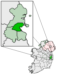
pin coords =
north coord = 53.3835
west coord = 06.2750
irish grid =
area =
elevation =
province = Leinster
county = County Dublin
town pop =
rural pop =
census yr =
web =Ballygall (irish place name|Baile na nGall|Town of the Foreigners) is a townland and Catholic parish within the
northside suburbs of the city ofDublin , Ireland, settled byVikings in the 11th century. The name comes from the old pathway from the tolka river uphill toFinglas , where there was an early monastic settlement, so the route may have been in use as early as the fifth century AD. The route of the ancient roadway is thought to be similar to the existing route to Finglas via Ballygall Road East, Beneavin Road and Ballygall Road West.Ballygall lies within the southern part of ancient
Fingal , although the modern county of the same name has its southern boundary a bit further north. Ballygall lies between the villages ofFinglas andGlasnevin , and the old parish, now large suburban district, ofBallymun .Townland
The townland of Ballygall is bordered in the south by Griffith Avenue, in the north by Glasnevin Avenue, to the east by Ballymun Road and the west by Beneavin. The centre of the townland is located where St. Canices Road and Ballygall Road cross in front of the Church of the Our Mother of Divine Grace. Historically, a large part of the original townland of Ballygall belonged to the Ball family and their manor house was located in the modern housing estate called Hillcrest Park. Ballygall House was located close to the central green in Hillcrest Park. The Ballygall estate which belonged to the Ball family in the 16th century was used for agricultural purposes right up to the 1960s when the last owners, the Craigie family, sold it for housing development.
Catholic parish
The Roman Catholic parish of Ballygall was constituted in 1964 from Glasnevin parish. The first parish priest was Michael Lamb. From 1964 to 1988 parishioners used a temporary "tin church" for worship. It was replaced in 1988 when Cardinal Connell officially opened the new church which was built at a slight remove from the tin church on the edge of what was once the Ballygall demense or estate. The new church was designed by architects Scott, Tallon and Walker. The building of the church was led by Seamus Moloney who was parish priest at the time.
List of parish priests of Ballygall
*Michael Lamb PP
*Daniel Barrett PP
*Phelim McCabe HFC PP
*Seamus Moloney PP
*Michael Flanagan PP
*Bert Kelly PP
*Brendan Quinlivan PPParish schools
*Sacred Heart Boys National School
*Mother of Divine Grace Girls National School
*St. Kevin's College (CBS)
*Coláiste Chiaráin (Special Education)Notable people from Ballygall
*Blessed
Margaret Ball (1514-1584), Irish martyr
*Barney Rock , Dublin County footballer 1979-1991
*Senan Moloney, journalist
*Dr. James O'Higgins-Norman (1968- ), priest and academic
*Colm Meaney (1953- ), actor
*David O'Leary (1958- ), Irish soccer international footballer
*Jim McQuaid, cyclist 1948 Olympics
*Marian Finnucane, broadcaster
*Dr.Patrick Cosgrave (1941-2001), journalist, writer and special advisor to Margaret Thatcher
Wikimedia Foundation. 2010.