- Charles Mix County, South Dakota
-
Charles Mix County, South Dakota 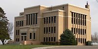 Charles Mix County Courthouse in Lake Andes
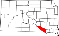
Location in the state of South Dakota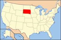
South Dakota's location in the U.S.Founded information needed Seat Lake Andes Area
- Total
- Land
- Water
1,150 sq mi (2,979 km²)
1,098 sq mi (2,843 km²)
53 sq mi (136 km²), 4.57%Population
- (2010)
- Density
9,129
8/sq mi (3/km²)Charles Mix County is a county located in the U.S. state of South Dakota. As of the 2010 census, the population was 9,129. Its county seat is Lake Andes.[1] The county was named after Charles Eli Mix, an official of the Bureau of Indian Affairs influential in signing a peace treaty with the local Lakota Indian tribes.[2]
Contents
Geography
According to the U.S. Census Bureau, the county has a total area of 1,150 square miles (2,978.5 km2), of which 1,098 square miles (2,843.8 km2) is land and 53 square miles (137.3 km2) (4.57%) is water. It is also noted[by whom?] for being shaped like California, including having a body of water on its western border.
Townships
 Civil townships in Charles Mix County in 1931
The county is divided into twenty-four townships: Bryan, Carroll, Choteau Creek, Darlington, Forbes, Goose Lake, Hamilton, Highland, Howard, Jackson, Kennedy, La Roche, Lake George, Lawrence, Lone Tree, Moore, Platte, Plain Center, Rhoda, Roe, Rouse, Signal, Waheheh, White Swan; and one area of unorganized territory: Castalia.
Major highways
 U.S. Highway 18
 U.S. Highway 281
 South Dakota Highway 44
 South Dakota Highway 45
 South Dakota Highway 46
 South Dakota Highway 50
 South Dakota Highway 1804
Adjacent counties
- Brule County, South Dakota - north
- Aurora County, South Dakota - northeast
- Douglas County, South Dakota - northeast
- Hutchinson County, South Dakota - east
- Bon Homme County, South Dakota - east
- Knox County, Nebraska - southeast
- Boyd County, Nebraska - southwest
- Gregory County, South Dakota - west
National protected areas
Demographics
Historical populations Census Pop. %± 1870 152 — 1880 407 167.8% 1890 4,178 926.5% 1900 8,498 103.4% 1910 14,899 75.3% 1920 16,256 9.1% 1930 16,703 2.7% 1940 13,449 −19.5% 1950 15,558 15.7% 1960 11,785 −24.3% 1970 9,994 −15.2% 1980 9,680 −3.1% 1990 9,131 −5.7% 2000 9,350 2.4% 2010 9,129 −2.4% U.S. Decennial Census As of the census[3] of 2000, there were 9,350 people, 3,343 households, and 2,326 families residing in the county. The population density was 8 people per square mile (3/km²). There were 3,853 housing units at an average density of 4 per square mile (1/km²). The racial makeup of the county was 69.65% White, 0.13% Black or African American, 28.28% Native American, 0.10% Asian, 0.01% Pacific Islander, 0.47% from other races, and 1.37% from two or more races. 1.89% of the population were Hispanic or Latino of any race. 23.9% were of German, 10.2% Czech, 10.1% Dutch and 5.5% Norwegian ancestry.
There were 3,343 households out of which 34.20% had children under the age of 18 living with them, 53.10% were married couples living together, 11.70% had a female householder with no husband present, and 30.40% were non-families. 28.30% of all households were made up of individuals and 15.10% had someone living alone who was 65 years of age or older. The average household size was 2.74 and the average family size was 3.37.
In the county, the population was spread out with 32.00% under the age of 18, 7.10% from 18 to 24, 23.20% from 25 to 44, 20.40% from 45 to 64, and 17.30% who were 65 years of age or older. The median age was 36 years. For every 100 females there were 96.60 males. For every 100 females age 18 and over, there were 94.10 males.
The median income for a household in the county was $26,060, and the median income for a family was $30,688. Males had a median income of $24,747 versus $19,688 for females. The per capita income for the county was $11,502. About 20.80% of families and 26.90% of the population were below the poverty line, including 35.50% of those under age 18 and 21.00% of those age 65 or over.
Cities and towns
Notable residents
- Jack Sully was elected sheriff in 1872.
See also
References
- ^ "Find a County". National Association of Counties. http://www.naco.org/Counties/Pages/FindACounty.aspx. Retrieved 2011-06-07.
- ^ Charles Mix County
- ^ "American FactFinder". United States Census Bureau. http://factfinder.census.gov. Retrieved 2008-01-31.

Brule County Aurora County and Douglas County Gregory County 
Hutchinson County and Bon Homme County  Charles Mix County, South Dakota

Boyd County, Nebraska Knox County, Nebraska Municipalities and communities of Charles Mix County, South Dakota Cities Geddes | Lake Andes | Platte | Wagner

Towns CDP Indian reservation Categories:- South Dakota counties
- Charles Mix County, South Dakota
- South Dakota counties on the Missouri River


Wikimedia Foundation. 2010.