- Obertraubling
-
Obertraubling 
 ObertraublingLocation of Obertraubling within Regensburg district
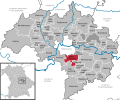
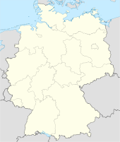
Coordinates 48°57′57″N 12°10′1″E / 48.96583°N 12.16694°ECoordinates: 48°57′57″N 12°10′1″E / 48.96583°N 12.16694°E Administration Country Germany State Bavaria Admin. region Oberpfalz District Regensburg Local subdivisions 5 Ortsteile Mayor Alfons Lang (CSU) Basic statistics Area 24.82 km2 (9.58 sq mi) Elevation 344 m (1129 ft) Population 7,734 (31 December 2010)[1] - Density 312 /km2 (807 /sq mi) Other information Time zone CET/CEST (UTC+1/+2) Licence plate R Postal code 93083 Area code 09401 Website www.obertraubling.de Obertraubling is a municipality in Bavaria, Upper Palatinate (German: Oberpfalz), in the district of Regensburg.
Contents
Geographically Location
Obertraubling ist located directly on the southend of the City of Regensburg, the capital of Upper Palatinate.
Community Population divided by subdivisions:
- Einthal (28)
- Embach (44)
- Gebelkofen (568)
- Höhenhof (23)
- Niedertraubling (653)
- Oberhinkofen (920)
- Obertraubling (4,121)
- Piesenkofen (686)
- Scharmassing (197)
- Tenacker (11)
In 1972 the so far independent municipalities Niedertraubling, Gebelkofen and Oberhinkofen joined with Obertraubling and became one municipality.
Politics
Former and present Mayor:
- Sebastian Pindorfer from 1926 till 1941
- Josef Wieland from 1941 till 1945
- Max Hirtreiter from 1945 bis 1948
- Josef Bäumel (PWG) from 1948 till 1967
- Hermann Zierer (CSU) from 1967 till 1981
- Leo Graß (FW) from 1981 till 1996
- Alfons Lang (CSU) from 1996 till 2014
Community Council:
- Gertraud Grief (CSU), Franz Aukofer (CSU), Marcus Weigl(CSU), Werner Schwarz(CSU), Rainer Tetzlaff (CSU), Jürgen Hofer (CSU), Petra Rothammer (CSU), Sebastian Treitinger (CSU), Gottfried Gruber (CSU), Anton Schaffer (CSU), Josef Heigl (CSU), Beate Konrad (SPD), Rainer Sinn (SPD), Franz Rieger (SPD) Anton Stadler (UBO), Wolfgang Hankofer (UBO), Karl Span (FW), Rudolf Graß (FW), Anna-Elise Dechant (FW), Michael Hitzler (FW).
Terms of election: every six years (May 2008 till Mai 2014).
Education
- Hermann-Zierer-Schule, Piesenkofener Str. 11, public school (1st till 4th grade)
- Realschule, Walhallastraße 24, secondary school (5th till 10th grade)
- Public library, Brunnweg
Twin towns
References
- ^ "Fortschreibung des Bevölkerungsstandes" (in German). Bayerisches Landesamt für Statistik und Datenverarbeitung. 31 December 2010. https://www.statistikdaten.bayern.de/genesis/online?language=de&sequenz=tabelleErgebnis&selectionname=12411-009r&sachmerkmal=QUASTI&sachschluessel=SQUART04&startjahr=2010&endjahr=2010.
External links
Alteglofsheim · Altenthann · Aufhausen · Bach an der Donau · Barbing · Beratzhausen · Bernhardswald · Brennberg · Brunn · Deuerling · Donaustauf · Duggendorf · Hagelstadt · Hemau · Holzheim am Forst · Kallmünz · Köfering · Laaber · Lappersdorf · Mintraching · Mötzing · Neutraubling · Nittendorf · Obertraubling · Pentling · Pettendorf · Pfakofen · Pfatter · Pielenhofen · Regenstauf · Riekofen · Schierling · Sinzing · Sünching · Tegernheim · Thalmassing · Wenzenbach · Wiesent · Wolfsegg · Wörth an der Donau · Zeitlarn
 Categories:
- Municipalities in Bavaria
- Regensburg district


Wikimedia Foundation. 2010.