- Lackawanna County, Pennsylvania
-
Lackawanna County, Pennsylvania 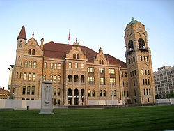 Lackawanna County Courthouse
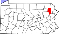
Location in the state of Pennsylvania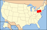
Pennsylvania's location in the U.S.Founded August 13, 1878 Seat Scranton Largest city Scranton Area
- Total
- Land
- Water
465 sq mi (1,204 km²)
459 sq mi (1,189 km²)
6 sq mi (16 km²), 1.27%Population
- (2010)
- Density
214,437
467/sq mi (180.3/km²)Website www.lackawannacounty.org Lackawanna County is a county in the U.S. state of Pennsylvania. It lies at the northern edge of the Coal Region, northwest of the Poconos. It was created on August 13, 1878, from part of Luzerne County and is Pennsylvania's most recently established county. It is named for the Lackawanna River. The county has a population of 214,437 as of 2010 and its county seat is Scranton.
Contents
Geography
According to the U.S. Census Bureau, the county has a total area of 465 square miles (1,204.3 km2), of which 459 square miles (1,188.8 km2) is land and 6 square miles (15.5 km2) (1.27%) is water.
Adjacent counties
- Susquehanna County (north)
- Wayne County (east)
- Monroe County (southeast)
- Luzerne County (southwest)
- Wyoming County (west)
Demographics
Historical populations Census Pop. %± 1880 89,269 — 1890 142,088 59.2% 1900 193,831 36.4% 1910 259,570 33.9% 1920 286,311 10.3% 1930 310,397 8.4% 1940 301,243 −2.9% 1950 257,396 −14.6% 1960 234,531 −8.9% 1970 234,107 −0.2% 1980 227,908 −2.6% 1990 219,039 −3.9% 2000 213,295 −2.6% 2010 214,437 0.5% [1][2] As of the census[3] of 2000, there were 213,295 people, 86,218 households, and 55,783 families residing in the county. The population density was 465 people per square mile (180/km²). There were 95,362 housing units at an average density of 208 per square mile (80/km²). The racial makeup of the county was 96.65% White, 1.31% Black or African American, 0.09% Native American, 0.75% Asian, 0.01% Pacific Islander, 0.53% from other races, and 0.66% from two or more races. 1.39% of the population were Hispanic or Latino of any race. 22.5% were of Italian, 21.2% Irish, 15.4% Polish and 10.2% German ancestry according to Census 2000.
There were 86,218 households out of which 27.20% had children under the age of 18 living with them, 48.90% were married couples living together, 11.80% had a female householder with no husband present, and 35.30% were non-families. 31.30% of all households were made up of individuals and 15.70% had someone living alone who was 65 years of age or older. The average household size was 2.38 and the average family size was 3.00.
In the county, the population was spread out with 21.80% under the age of 18, 8.90% from 18 to 24, 26.40% from 25 to 44, 23.50% from 45 to 64, and 19.50% who were 65 years of age or older. The median age was 40 years. For every 100 females there were 89.30 males. For every 100 females age 18 and over, there were 85.40 males.
Municipalities
 Map of Lackawanna County, Pennsylvania with Municipal Labels showing Cities and Boroughs (red), Townships (white), and Census-designated places (blue).
Under Pennsylvania law, there are four types of incorporated municipalities: cities, boroughs, townships, and, in at most two cases, towns. The following cities, boroughs and townships are located in Lackawanna County:
Cities
Boroughs
Townships
- Benton Township
- Carbondale Township
- Clifton Township
- Covington Township
- Elmhurst Township
- Fell Township
- Glenburn Township
- Greenfield Township
- Jefferson Township
- La Plume Township
- Madison Township
- Newton Township
- North Abington Township
- Ransom Township
- Roaring Brook Township
- Scott Township
- South Abington Township
- Spring Brook Township
- Thornhurst Township
- Waverly Township
- West Abington Township
Census-designated places
Census-designated places are geographical areas designated by the U.S. Census Bureau for the purposes of compiling demographic data. They are not actual jurisdictions under Pennsylvania law. Other unincorporated communities, such as villages, may be listed here as well.
- Big Bass Lake
- Chinchilla
- Eagle Lake
- Glenburn
- Mount Cobb
- Simpson
- Waverly
 Statue of George Washington (dedicated July 4, 1893) at Lackawanna County Courthouse
 Scenery in Lackawanna County
Villages
Politics
As of November 2010, there are 146,383 registered voters in Lackawanna County.[4]
- Democratic: 96,471 (65.9%)
- Republican: 38,297 (26.2%)
- Other parties and independents: 11,615 (7.9%)
The Democratic Party has been historically dominant in county-level politics.[citation needed] On the state and national levels, Lackawanna County leans toward the Democratic Party. In 2000, Democrat Al Gore won 60% of the vote and Republican George W. Bush won 36%.[5] In 2004, Democrat John Kerry received 56% of the vote and Bush received 42%.[6] In 2006, Democrats Governor Ed Rendell and Senator Bob Casey, Jr. won 70% and 73% of the vote in Lackawanna County, respectively.[7] In 2008, three of four Democrats running statewide carried the county, with Barack Obama receiving 63% of the county vote to 37% for John McCain.[8]
County commissioners
- Michael Washo, Chairman, Democrat
- Corey D. O'Brien, Vice-chairman, Democrat
- Bruce Smallacombe, Republican
Other county offices
- Clerk of Judicial Records, Mary Rinaldi, Democrat
- Controller, Ken McDowell, Democrat
- Coroner, Timothy Rowland, Democrat
- District Attorney, Andy Jarbola III, Republican
- Recorder of Deeds, Evie Rafalko-McNulty, Democrat
- Register of Wills, Linda Munley, Democrat
- Sheriff, John Szymanski, Democrat
- Treasurer, Edward Karpovich, Democrat
State Representatives
- Kenneth J. Smith, Democrat, 112nd district
- Kevin Murphy, Democrat, 113rd district
- Sid Michaels Kavulich, Democrat, 114th district
- Edward Staback, Democrat, 115th district
State Senator
- John P. Blake, Democrat, 22nd district
United States House of Representatives
- Tom Marino, Republican, Pennsylvania's 10th congressional district
- Lou Barletta, Republican, Pennsylvania's 11th congressional district
United States Senator
- Robert Casey, Democrat
- Pat Toomey, Republican
Education
Colleges and universities
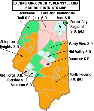
 Map of Lackawanna County, Pennsylvania School Districts
- Baptist Bible College
- Johnson College
- Keystone College
- Lackawanna College
- Marywood University
- Penn State Worthington Scranton
- The Commonwealth Medical College
- University of Scranton
Public School Districts
- Abington Heights School District
- Carbondale Area School District
- Dunmore School District
- Forest City Regional School District (also in Susquehanna and Wayne Counties)
- Lackawanna Trail School District (also in Wyoming County)
- Lakeland School District
- Mid Valley School District
- North Pocono School District (also in Wayne County)
- Old Forge School District
- Riverside School District
- Scranton School District
- Valley View School District
Charter schools
- Fell Charter Elementary School - public charter school offering Kindergarten through 8th grade, on Rt 171 in Simpson, PA. [1] Report Card 2010 [2]
- Scranton School for Deaf and Hard-of-Hearing Children - public charter school offering Pre-K through 12th grade education to eligible deaf and hard of hearing children. Located in South Abington Township, PA.
Public Vo-Tech Schools
- Career Technology Center of Lackawanna County
Diocesan Schools
The county is also served by the Diocese of Scranton. The Diocese of Scranton operates four regional systems of diocesan schools. The Holy Cross School System serves Lackawanna County, and is currently composed of seven elementary centers and one secondary center. The Holy Cross System is the second-largest of the four systems, and Holy Cross High School is the only diocesan high school operating a capacity. The Holy Cross System is the result of diocesan-wide consolidations made in 2007 in response to decades of declining enrollment. As recently as 2000, Lackawanna County was home to four high schools and nearly fifteen elementary schools. While the current configuration of sites and schools educates a fraction of the students once enrolled in Catholic schools in Lackawanna County, vast improvements have been made to the curriculum, and millions of dollars of capital gains have been invested in the buildings and technologies of the schools. As part of the ongoing effort to stabilize enrollment and offer a sustainable school system which is "spiritually sound and academically excellent," the Holy Cross System is embarking on a more aggressive advertising campaign to promote Catholic education and establish stronger and more diverse programs at the elementary level. Additionally, Sacred Heart Elementary in Carbondale and Marian Catholic Elementary in Scranton will close next year and be incorporated into LaSalle Academy and All Saint's Academy, respectively. This will cut the costs of sustaining two faculties and buildings which currently operate at less than fifty-percent capacity collectively, and bolster the enrollments of the hubs of elementary education.
- Holy Cross High School, Dunmore
- Our Lady of Peace Elementary, Clarks Summit
- St. Mary of Mount Carmel Elementary, Dunmore
- LaSalle Academy, Dickson City and Jessup
- All Saints Academy, Scranton
- St. Clare/St. Paul Elementary, Scranton
Private Schools
As reported by the National Center for Educational Statistics of the US Department of Education.[9]
- Abington Christian School, Clarks Green, GR PreK-8
- Bais Yaakov of Scranton, GR 9-12
- DePaul School, Scranton, Special Education - GR 2-8
- Howard Gardner School for Discovery, Scranton, GR PreK-8
- Little People Daycare School, Scranton, GR PreK-KG
- Lourdesmont School, Scranton, Special Education - GR 7-12
- Lutheran Academy - Scranton, GR 1-9
- Marywood - Tony Damiano Early Childhood Center, Scranton, GR PreK-KG
- Milton Eisner Yeshiva High School, Scranton, GR 9-12
- Montessori Kindergarten, Scranton, GR PreK-KG
- Revival Baptist Christian School, Scranton, GR K-11
- Scranton Hebrew Day School, Scranton, GR K-8
- Scranton Preparatory School, Scranton, GR 9-12
- St. Gregory's Early Childhood Center, Clarks Green, GR PreK-KG
- St. Gregory's Academy, Elmhurst Township, GR 9-12
- St. Stanislaus Elementary School, Scranton, GR K-8
- Summit Christian Academy, South Abington Township, PreK-12
- The Geneva School, Olyphant, GR PreK-8
- Triboro Christian Academy, Old Forge, K-12, It participates in the state's PSSA annual testing.
See also
- List of municipal authorities in Lackawanna County, Pennsylvania
- National Register of Historic Places listings in Lackawanna County, Pennsylvania
References
- ^ http://factfinder2.census.gov
- ^ http://mapserver.lib.virginia.edu/
- ^ "American FactFinder". United States Census Bureau. http://factfinder.census.gov. Retrieved 2008-01-31.
- ^ http://www.dos.state.pa.us/elections/lib/elections/055_voter_registration_statistics/currentstats/currentvotestats.xls
- ^ "Commonwealth of PA – Elections Information". http://www.electionreturns.state.pa.us/ElectionsInformation.aspx?FunctionID=12&ElectionID=2. Retrieved 2009-03-10.
- ^ "Commonwealth of PA – Elections Information". http://www.electionreturns.state.pa.us/ElectionsInformation.aspx?FunctionID=12&ElectionID=11. Retrieved 2009-03-10.
- ^ "Commonwealth of PA – Elections Information". http://www.electionreturns.state.pa.us/ElectionsInformation.aspx?FunctionID=12&ElectionID=24. Retrieved 2009-03-10.
- ^ "Commonwealth of PA – Elections Information". http://www.electionreturns.state.pa.us/ElectionsInformation.aspx?FunctionID=12&ElectionID=28. Retrieved 2009-03-10.
- ^ National Center for Education Statistics Institute of Education Sciences,. "Private School Universe Survey 2009-2010 School Year". http://nces.ed.gov/surveys/pss/privateschoolsearch/.
External links
Municipalities and communities of Lackawanna County, Pennsylvania Cities 
Boroughs Townships Benton | Carbondale | Clifton | Covington | Elmhurst | Fell | Glenburn | Greenfield | Jefferson | La Plume | Madison | Newton | North Abington | Ransom | Roaring Brook | Scott | South Abington | Spring Brook | Thornhurst | Waverly | West Abington
CDPs Unincorporated
communityCounties Settlements
50k-100kSettlements
25k-50kSettlements
10k-25kCoordinates: 41°26′N 75°37′W / 41.44°N 75.61°W
Categories:- Pennsylvania counties
- Lackawanna County, Pennsylvania
- The Poconos
- Anthracite Coal Region of Pennsylvania
- 1878 establishments
- Scranton, Pennsylvania


Wikimedia Foundation. 2010.