- Dauphin County, Pennsylvania
-
Dauphin County, Pennsylvania 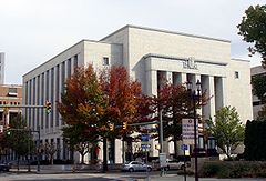
Seal of Dauphin County, Pennsylvania
Seal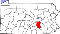
Location in the state of Pennsylvania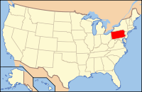
Pennsylvania's location in the U.S.Founded March 4, 1785 Seat Harrisburg Largest city Harrisburg Area
- Total
- Land
- Water
558 sq mi (1,445 km²)
525 sq mi (1,360 km²)
32 sq mi (83 km²),Population
- (2010)
- Density
268,100
510/sq mi (197.1/km²)Website www.dauphincounty.org Dauphin County (
 /ˈdɔːfɪn/) is a county in the U.S. state of Pennsylvania and is one of the three counties comprising the Harrisburg–Carlisle Metropolitan Statistical Area. As of 2010 census, the population was 268,100. The county includes the city of Harrisburg, which has served as the state capital since 1812. Also located within the county is Three Mile Island Nuclear Generating Station, site of the 1979 nuclear core meltdown.
Dauphin County was created on March 4, 1785, from part of Lancaster County and was named after Louis-Joseph, Dauphin of France the first son of Louis XVI. Louis-Joseph's title of Dauphin signified that he was the heir apparent to the throne of France. The county seat is Harrisburg, Pennsylvania's capital and tenth largest city.[1]
Contents
Geography
According to the U.S. Census Bureau, the county has a total area of 558 square miles (1,450 km2), of which 525 square miles (1,360 km2) is land and 32 square miles (83 km2) (5.78%) is water. The county is bound to its western border by the Susquehanna River.
Adjacent counties
- Northumberland County (north)
- Schuylkill County (northeast)
- Lebanon County (east)
- Lancaster County (south)
- York County (southwest)
- Cumberland County (west)
- Perry County (west)
Major Highways
Demographics
Historical populations Census Pop. %± 1790 18,155 — 1800 22,270 22.7% 1810 31,883 43.2% 1820 21,653 −32.1% 1830 25,243 16.6% 1840 30,118 19.3% 1850 35,754 18.7% 1860 46,756 30.8% 1870 60,740 29.9% 1880 76,148 25.4% 1890 96,977 27.4% 1900 114,443 18.0% 1910 136,152 19.0% 1920 153,116 12.5% 1930 165,231 7.9% 1940 177,410 7.4% 1950 197,784 11.5% 1960 220,255 11.4% 1970 223,834 1.6% 1980 232,317 3.8% 1990 237,813 2.4% 2000 251,805 5.9% 2010 268,100 6.5% [2][3] As of the 2010 census, the county was 72.7% White, 18.0% Black or African American, 0.2% Native American, 3.2% Asian, and 3.1% were two or more races. 7.0% of the population were of Hispanic or Latino ancestry[1].
As of the census[4] of 2000, there were 251,798 people, 102,670 households, and 66,119 families residing in the county. The population density was 479 people per square mile (185/km²). There were 111,133 housing units at an average density of 212 per square mile (82/km²). The racial makeup of the county was 77.11% White, 16.91% Black or African American, 0.16% Native American, 1.96% Asian, 0.03% Pacific Islander, 1.97% from other races, and 1.85% from two or more races. 4.13% of the population were Hispanic or Latino of any race. 29.2% were of German, 7.5% Irish, 7.3% American and 7.2% Italian ancestry according to Census 2000. 91.8% spoke English and 3.9% Spanish as their first language.
According to 2005 estimates, 73.9% of the county's population was non-Hispanic whites. 17.8% of the population was African-Americans. 2.5% were Asians. Latinos now were 5.0% of the population.[5]
In 2000 there were 102,670 households out of which 29.70% had children under the age of 18 living with them, 47.60% were married couples living together, 12.90% had a female householder with no husband present, and 35.60% were non-families. 30.00% of all households were made up of individuals and 10.30% had someone living alone who was 65 years of age or older. The average household size was 2.39 and the average family size was 2.98.
In the county, the population was spread out with 24.30% under the age of 18, 7.60% from 18 to 24, 30.10% from 25 to 44, 23.80% from 45 to 64, and 14.20% who were 65 years of age or older. The median age was 38 years. For every 100 females there were 92.30 males. For every 100 females age 18 and over, there were 88.80 males.
Politics and government
As of November 2008, there are 192,743 registered voters in Dauphin County [2].
- Democratic: 86,870 (45.07%)
- Republican: 81,853 (42.47%)
- Other Parties: 24,020 (12.46%)
Like most of the rest of the Susquehanna Valley, Dauphin County was once reliably Republican, and the commissioner majority and all county row offices remain in Republican hands. However, there has been a decided shift toward the Democrats in recent years, who overtook the Republican countywide registration during the summer of 2008. Bob Casey Jr. carried the county in the 2006 Senate election when he unseated Rick Santorum. According to the Dauphin County Board of Elections, in 2008 Barack Obama became the first Democratic presidential candidate to carry Dauphin County since 1964, receiving 9.0% more of the vote than John McCain. The other three statewide winners (Rob McCord for Treasurer, Jack Wagner for Auditor General, and Tom Corbett for Attorney General) also carried Dauphin. [3]
County commissioners
- Jeffrey Haste, Chairman, Republican
- Michael Pries, Republican
- George P. Hartwick III, Democrat
Other county offices
- Clerk of Courts, Dale Klein, Republican
- Controller, Marie Rebuck, Republican
- Coroner, Graham Hetrick, Republican
- District Attorney, Ed Marsico, Republican
- Prothonotary, Steve Farina, Republican
- Recorder of Deeds, Jim Zugay, Republican
- Register of Wills, Sandy Snyder, Republican
- Sheriff, Jack Lotwick, Republican
- Treasurer, Janis Creason, Republican
- Solicitor, William T. Tully, Esquire
State Representatives
- David Hickernell, Republican, 98th district
- Ron Buxton, Democrat, 103rd district
- Sue Helm, Republican, 104th district
- Ron Marsico, Republican, 105th district
- John Payne, Republican, 106th district
State Senate
- Jeffrey Piccola, Republican, 15th district
- John Gordner, Republican, 27th district
- Mike Folmer, Republican, 48th district
US House of Representatives
- Tim Holden, Democrat, 17th district
United States Senate
Senator Party Pat Toomey Republican Bob Casey Democrat Municipalities in Dauphin County
 Map of Dauphin County, Pennsylvania with Municipal Labels showing Cities and Boroughs (red), Townships (white), and Census-designated places (blue).
Under Pennsylvania law, there are four types of incorporated municipalities: cities, boroughs, townships, and, in at most two cases, towns. The following cities, boroughs and townships are located in Dauphin County:
Cities
- Harrisburg is the only incorporated city in Dauphin County.
See also: List of Harrisburg neighborhoodsBoroughs
Townships
- Londonderry Township
- Lower Paxton Township
- Lower Swatara Township
- Lykens Township
- Middle Paxton Township
- Mifflin Township
- Reed Township
- Rush Township
- South Hanover Township
- Susquehanna Township
- Swatara Township
- Upper Paxton Township
- Washington Township
- Wayne Township
- West Hanover Township
- Wiconisco Township
- Williams Township
Unincorporated and Census-designated places
Census-designated places are geographical areas designated by the U.S. Census Bureau for the purposes of compiling demographic data. They are not actual jurisdictions under Pennsylvania law. Other unincorporated communities, such as villages, may be listed here as well.
Census-designated places
Unincorporated villages
- Bachmanville
- Beaufort Farms
- Dietrich
- Deodate
- Carsonville
- Catalina
- Ebenezer
- Edgemont
- Ellendale Forge
- Enders
- Enterline
- Estherton
- Fort Hunter
- Grantville
- Hanoverdale
- Heckton
- Hillside Village
- Hockersville
- Hoernerstown
- Inglenook
- Jednota
- Killinger
- Lucknow
- Malta
- Manada Gap
- Manada Hill
- Matamoras
- Montrose Park
- Oakleigh
- Oakmont
- Oberlin Gardens
- Paxtang Manor
- Palmdale
- Piketown
- Powells Valley
- Ritzie Village
- Rockville
- Sand Beach
- Shellsville
- Singersville
- Swatara
- Vaughn
- Union Deposit
- Waynesville
- Windsor Farms
Education
 Map of Dauphin County, Pennsylvania School Districts
Colleges and universities
Public School Districts
- Central Dauphin School District
- Derry Township School District
- Halifax Area School District
- Harrisburg School District (Pennsylvania)
- Lower Dauphin School District
- Middletown Area School District
- Millersburg School District
- Steelton-Highspire School District
- Susquehanna Township School District
- Susquenita School District (also in Perry County)
- Upper Dauphin School District
- Williams Valley School District (also in Schuylkill County)
Public Charter Schools
Several public charter schools are established in Dauphin County [6]
- Infinity Charter School
- Pennsylvania Distance and Electronic Learning Charter School
- Sylvan Heights Science Charter School
- Capital Area School for the Arts
Intermediate Unit
The Capital Area Intermediate Unit 15 is a state approved education agency that offers: school districts, charter schools, private schools, and home school students, a variety of services including: a completely developed K-12 curriculum that is mapped and aligned with the Pennsylvania Academic Standards (available online), shared services, a group purchasing program and a wide variety of special education and special needs services.
Library system
The Dauphin County Library System provides library service to the residents of the county through a main library in Harrisburg, Pennsylvania and seven branch libraries. DCLS is a private, non-profit corporation. It is governed by a 17-member Board of Trustees, five appointed annually by the Dauphin County Commissioners, and twelve elected for three-year terms. The library is a member of the Pennsylvania library system.
Private Schools
As reported by the National Center for Educational Statistics[7]
- Armstrong Valley Christian School - Halifax
- Berrysburg Christian Academy - Elizabethvile
- Bishop McDevitt High School - Harrisburg
- Cathedral Consolidated School - Harrisburg
- Covenant Christian Academy - Harrisburg
- East Shore Montessori School - Harrisburg
- Emmanuel Wesleyan Academy - Gratz
- Garden Spot Amish School - Millersburg
- Garden Spot School - Millersburg
- Goddard School - Harrisburg
- Hansel and Gretel Early Learning Centers - Harrisburg
- Harrisburg Adventist School - Harrisburg
- Harrisburg Christian School - Harrisburg
- Hershey Christian School - Hershey
- Hillside Amish School - Harrisville
- Hillside Seventh Day Adventist School - Harrisburg
- Keystone Math and Science Academy - Harrisburg
- Kinder-Care Learning Center - Harrisburg
- KinderCare Learning Center - Hershey
- Londonderry School - Harrisburg
- Mahantango School - Lykens
- Matterstown School - Millersburg
- Middletown Christian School - Middletown
- Milton Hershey School - Hershey
- North Mountain View Amish - Millersburg
- Northern Dauphin Christian School - Millersburg
- Pride of the Neighborhood Academies - Harrisburg
- Prince of Peace School - Steelton
- Rakers Mill School - Elizabethville
- Rolling Acres School - Lykens
- Seven Sorrows of BMV School - Middletown
- Sonshine Learning Station - Middletown
- South Mountain View School - Spring Glen
- Specktown School - Lykens
- St. Catherine Laboure School - Harrisburg
- St Joan of Arc Elementary School - Hershey
- St. Margaret Mary School - Harrisburg
- St. Stephen's Episcopal School - Harrisburg
- Tender Years Inc. - Hershey
- The Nativity School of Harrisburg - Harrisburg
- Windy Knoll School - Spring Glen
- Wordsworth Academy - Harrisbrug
- Yeshiva Academy - Harrisburg
Recreation
There are two Pennsylvania state parks in Dauphin County.
See also
- Harrisburg Regional Chamber
- Hummelstown brownstone
- List of municipal authorities in Dauphin County, Pennsylvania
- National Register of Historic Places listings in Dauphin County, Pennsylvania
References
- ^ "Find a County". National Association of Counties. http://www.naco.org/Counties/Pages/FindACounty.aspx. Retrieved 2011-06-07.
- ^ http://factfinder2.census.gov
- ^ http://mapserver.lib.virginia.edu/
- ^ "American FactFinder". United States Census Bureau. http://factfinder.census.gov. Retrieved 2008-01-31.
- ^ Dauphin County QuickFacts from the US Census Bureau
- ^ Pennsylvania Department of Education Approved Public Charter Schools, January 2010
- ^ ies, National Center for Education Statistics, US Department of Education, Institute of Education Sciences, Private School Universe Survey 2008
External links
- County of Dauphin (official website)
- The Historical Society of Dauphin County
- Dauphin County Library System
City of Harrisburg City Flag • City Island • Companies • County • Downtown • History • Historic sites • Hospitals • Language • Mayors • Metropolitan Area • Neighborhoods • Region • School District • State Capitol • Sports

Municipalities and communities of Dauphin County, Pennsylvania City 
Boroughs Berrysburg | Dauphin | Elizabethville | Gratz | Halifax | Highspire | Hummelstown | Lykens | Middletown | Millersburg | Paxtang | Penbrook | Pillow | Royalton | Steelton | Williamstown
Townships Conewago | Derry | East Hanover | Halifax | Jackson | Jefferson | Londonderry | Lower Paxton | Lower Swatara | Lykens | Middle Paxton | Mifflin | Reed | Rush | South Hanover | Susquehanna | Swatara | Upper Paxton | Washington | Wayne | West Hanover | Wiconisco | Williams
CDPs Unincorporated
communitiesBachmanville | Beaufort Farms | Dietrich | Deodate | Carsonville | Catalina | Ebenezer | Edgemont | Ellendale Forge | Enders | Enterline | Estherton | Fort Hunter | Grantville | Hanoverdale | Hanover Heights | Heckton | Hillside Village | Hockersville | Hoernerstown | Inglenook | Jednota | Killinger | Loyalton | Lucknow | Manada Gap | Manada Hill | Matamoras | Montrose Park | Oakleigh | Oakmont | Oberlin Gardens | Paxtang Manor | Palmdale | Piketown | Powells Valley | Ridgeview | Ritzie Village | Rockville | Sand Beach | Shellsville | Singersville | Swatara | Vaughn | Union Deposit | Waynesville | Windsor Farms
Categories:- Pennsylvania counties
- Dauphin County, Pennsylvania
- 1785 establishments
- Harrisburg metropolitan area
- Susquehanna Valley


Wikimedia Foundation. 2010.