Cilgerran (hundred)

Cilgerran (hundred)

Coordinates: 51°59′24″N 4°33′40″W / 51.990°N 4.561°W / 51.990; -4.561

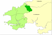
Pembrokeshire showing Cilgerran Hundred

The Hundred of Cilgerran (often written "Kilgerran") was a hundred in the north of Pembrokeshire, Wales. It was formed by the Act of Union of 1536 from the commote of the pre-Norman cantref of Emlyn that is in Pembrokeshire and is otherwise called in Welsh Emlyn Is Cuch (Emlyn below the River Cuch)[1], with the addition of the Cemais parish of Llantood. The area of the commote was about 106 km2: that of the hundred was 113 km2.

It was under the control of the medieval borough of Cilgerran. It was occupied by the Normans in the 12th century, and made part of the March, but remained exclusively Welsh-speaking. In addition to Cilgerran Castle, the Normans also constructed at least one other castle in the commote: Castell Chrychydd in Clydau[2].

The commote comprised the parishes of Bridell, Cilgerran, Clydau, Capel Colman , Llanfihangel Penbedw, Manordeifi and Penrydd, and the western part of Cilrhedyn[3].

Notes

  1. ^ B G Charles, Place-names of Pembrokeshire, NLoW, 1992, p 347
  2. ^ Howells, B, Walker, R. F., Pembrokeshire County History: Vol II: Medieval Pembrokeshire, Pembrokeshire Historical Society, 2002, ISBN 0-903771-10-1, p 523
  3. ^ Richards, Melville, Welsh Administrative and Territorial Units, UoW Press, 1969, p 66

Wikimedia Foundation. 2010.

Игры ⚽ Поможем решить контрольную работу

Look at other dictionaries:

  • Cilgerran — Coordinates: 52°03′12″N 4°38′02″W / 52.05322°N 4.63396°W / 52.05322; 4.63396 …   Wikipedia

  • Dewisland (hundred) — Coordinates: 51°56′53″N 5°08′28″W / 51.948°N 5.141°W / 51.948; 5.141 …   Wikipedia

  • Dungleddy (hundred) — Coordinates: 51°52′05″N 4°43′01″W / 51.868°N 4.717°W / 51.868; 4.717 …   Wikipedia

  • Narberth (hundred) — Coordinates: 51°47′53″N 4°44′35″W / 51.798°N 4.743°W / 51.798; 4.743 …   Wikipedia

  • Emlyn — was one of the seven cantrefi of Dyfed, an ancient district of Wales. It subsequently became part of Deheubarth in around 950. It consisted of the northern part of Dyfed bordering on the River Teifi. Its southern boundary followed the ridge of… …   Wikipedia

  • Cemais (Dyfed cantref) — For the cantref of the same name on Anglesey, see Cemais (Anglesey cantref). Cemais (sometimes spelled Kemes after one of the several variations found in medieval orthography) was a cantref of Dyfed, and now part of Pembrokeshire, Wales. It… …   Wikipedia

  • Pembrokeshire — Pembrokeshire …   Wikipedia

  • Manordeifi — The old parish church of St. David at Manordeifi Manordeifi (Welsh: Maenordeifi) is a parish and community in the hundred of Kilgerran, in the northeast corner of Pembrokeshire, Wales. The population of the community (2001) was 478. Together with …   Wikipedia

  • List of hundreds of England and Wales — This is a list of hundreds of England and Wales. Most English counties were divided into hundreds from the late Saxon period and they were effectively abolished under the Local Government Act of 1894.Fact|date=February 2007 In some areas,… …   Wikipedia

  • Clydau — parish church Clydau (sometimes written as Clydaï or Clydey) is a village, parish and community in the Hundred of Cilgerran, Pembrokeshire, Wales. The village is a small group of houses around the parish church, 8 km southwest of Newcastle Emlyn… …   Wikipedia

Share the article and excerpts

Direct link
Do a right-click on the link above
and select “Copy Link”