- Meopham
-
Coordinates: 51°21′50″N 0°21′36″E / 51.364°N 0.360°E
Meopham 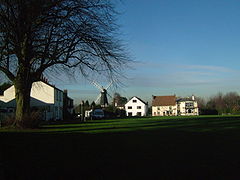
Meopham Green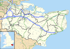
 Meopham
Meopham shown within KentPopulation 6,427 (2001) OS grid reference TQ645655 Parish Meopham District Gravesham Shire county Kent Region South East Country England Sovereign state United Kingdom Post town Gravesend Postcode district DA13 Dialling code 01474 Police Kent Fire Kent Ambulance South East Coast EU Parliament South East England UK Parliament Gravesham List of places: UK • England • Kent Meopham (
 /ˈmɛpəm/) is a large linear village and civil parish in the Borough of Gravesham and ceremonial county of Kent, in England, and lies to the south of Gravesend. The parish covers 6.5 square miles (17 km2), and comprises two villages and two smaller settlements; it has a population of 6,427.[1] Meopham has been described as having one of the longest village streets in Kent,[2] being 7 miles (11 km) in length.
Contents
History
The name of the village derives from Meapaham (Meapa's village): it is first recorded in 788, in the time of King Offa. The modern pronunciation of the name comes from different ways of writing and spelling.[3]
One of the hospitals founded during the Middle Ages was located here;[4] and three medieval manor houses - those of Meopham, Dodmore and Nurstead - governed the land now occupying the parish. Edward Hasted in 1797 described the village as being "out of the way" and with "no well frequented thoroughfare through it".[5] Since the 1920s, when the road numbering scheme started, the main road through the village, the A227, has become busier as a through route connecting North Kent with the M20 motorway at the foot of the North Downs, although this now has been somewhat relieved by the M25.
The Parish
The parish comprises the main village, divided into four named settlements; the outlying village of Harvel; and two other settlements: Culverstone and Dodmore. The Parish Council, which meets at Meopham Windmill, has twelve members.
The main village
From the north along the main A227, the four settlements are Hook Green; The Street (Dodmore); Meopham Green; and Culverstone. The first three are conservation areas. There were originally seven village greens in the parish; only three remain today.
Hook Green is the most northerly of the settlements. Originally called Hoo Green, it lies around a small triangular village green to the west of the main road. There are again many listed buildings in the area, including the Weavers Cottage.[6] More modern developments are situated near to Meopham railway station to the north, as is the Railway Tavern. There is also an Italian restaurant called Bartellas, previously a public house, known as the Fox & Hounds.
The Street (Dodmore) is the oldest of the village's settlements, where the manor house of Dodmore stands: it is close to the 14th century church, the parish church of St John the Baptist.[7] In addition, there are many other historic buildings, including The George Inn,[8] where the manorial court of Dodmore once sat. At The George Inn there is still the Courtroom Bar, the room in which the court baron of the manor was held. The present lord of the manor of Dodmore lives in the old manor house. The family of the cricketer Thomas Nordish worked Dodmore Farm. Recently Ifield CC relocated here, becoming New Ifield CC.
Meopham Green is by far the largest remaining village green in the parish.[9] The main road passes to the west; around the other two sides are buildings, many of which are of 18th and 19th century origin. Here are two public houses: the King's Arms;[10] and the The Cricketers Inn, formerly The Long Hop
Meopham Green is home to a cricket pitch, where the sport has been played since at least 1776,[11] and which is one of Kent's idyllic settings for the game;[12] Sir John Major, the former Prime Minister is Patron of Meopham Cricket Club and stood on a soapbox here during General Election campaigns. Meopham Windmill is nearby.
Culverstone Green is the most southerly of the main village settlements. The original village green has been given up to agriculture. On the main road, and down Whitepost Lane to the east, are both older and modern houses; a small supermarket; and a petrol station.
There is a considerable built-up area between the main road and Harvel. This is known as Culverstone Valley: it covers some 250 acres (100 ha) and lies among woodlands. It is described as a unique development, which in its origins was the result of the sale of plots of land in the 1930s. Originally, chalets, shacks and caravans were built on the plots. Since then unauthorised developments, often extending the original buildings, have taken place in an area which is now Green Belt. Poor access and limited facilities such as proper drainage has led Gravesham Borough Council to take action by curbing this trend.[13]
Other settlements
The other two main settlements in the parish are Nurstead, where Nurstead Court is located next to the parish church,[14] and there are several cottages nearby; and Camer, once home to the family of Smith-Masters, with a few cottages near Camer Park.[15]
Geography
The village lies on the northern slope of the North Downs, 480 feet (150 m) above sea level.
The Windmill
 Killick's Mill and the Green
 Main article: Killick's Mill, Meopham
The Mill was built by James Killick, a millwright from Strood, in 1801. After his death in 1823, it passed to his wife Sukey, then to his son James, and after to his grandson Thomas who died in 1891. The Killicks lived in Strood where the family also owned mills and were reputed to walk the eight miles to Meopham each day. The mill worked by wind until 1929 and then by engine until 1965. It has been fully restored and is now in full working order.
Churches
There are two parish churches: the Parish Church of St. John the Baptist, Meopham[16] and Nurstead's parish church of St. Mildred.[17] Other churches include Mount Zion Baptist Church built in 1828, located near Meopham Green, South Street Baptist Church,[18] north of Culverstone and the Catholic Church of St Paul, consecrated in 1965.[19]
Education
There are three State schools in the village: the secondary Meopham School has evolved into a specialist and sports college,[20] where Meopham Library is situated too; and two primary schools: Meopham Community Primary School and Culverstone Green Primary School. Gravesend Grammar School is within the borough, and nearby are fee-paying schools, such as Cobham Hall,[21] and King's School, Rochester.
Transport
The main road through the village, the A227, carries a large amount of traffic. It first became a main road under the Turnpike Acts in 1825, when it was designed to connect Gravesend with Wrotham.[3]
Meopham Railway Station, at the north end of the village, is on the Chatham Main Line which runs to Victoria Station in London. Ebbsfleet International Station is under 8 miles (13 km) away.
Notable people
Famous residents have included Simon de Mepham, Archbishop of Canterbury (1327–1332), John Tradescant the elder (c. 1570-1638) and his son of the same name (1608–1662), both botanists. Residents in more recent times have included the artists Spencer Gore (1878-1914) and Graham Sutherland (1903-1980), Michael Gilbert (1912-2006), the author, Harry Price (1881–1948), a psychic researcher, Hughie Green (1920–1997), the entertainer, and Kelvin MacKenzie, former editor of The Sun; current residents include Sir Michael Gambon, the actor, Lady de Grey, widow of Sir Roger de Grey, former President of the Royal Academy, as well as Donald Adamson, the author and historian,[22] and Major Sir Richard Gethin, Bt, who lives at Sole Street. The Arnold family were seated at Meopham Court, lately represented by Major Ralph Arnold[23].
See also
References
- ^ Office for National Statistics : Census 2001 : Parish Headcounts : Gravesham Retrieved 6 March 2010
- ^ Notes on the village
- ^ a b Golding-Bird, C.W. (1934). The History of Meopham. London: Williams & Norgate Ltd.
- ^ Kent History Illustrated Frank W Jessup, 1966 Kent County Council
- ^ British History Online
- ^ Hook Green Conservation Area
- ^ Meopham The Street Conservation Area
- ^ The George Inn
- ^ Meopham Green Conservation Area
- ^ The Kings Arms Public House
- ^ Meopham Cricket Club history
- ^ Meopham Cricket Club
- ^ Gravesham Borough Council : Culverstone Valley
- ^ Nurstead Court
- ^ Camer Park
- ^ North West Kent FHS
- ^ North West Kent FHS
- ^ South Street Baptist Church, Meopham
- ^ St Paul's RC, Meopham
- ^ Meopham School
- ^ Cobham Hall
- ^ Notes on the Manor of Dodmore
- ^ www.meopham.org
Additional reading
- The History of Meopham, C.H. Golding-Bird, 2000 (reprint from 1934 edition), Williams & Norgate Ltd
External links
 Media related to Meopham at Wikimedia Commons
Towns and villages in the Borough of Gravesham 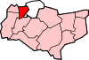 Chalk · Cobham · Culverstone Green · Dode · Harvel · Higham · Istead Rise · Luddesdown · Meopham · Meopham Green · Northfleet · Painters Ash · Singlewell or Ifield · Shorne · Sole Street · Springhead · Thong · VigoCategories:
- Gravesham
- Villages in Kent
- Civil parishes in Kent


Wikimedia Foundation. 2010.