- Crook County, Oregon
-
Crook County, Oregon 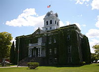
Crook County Courthouse in Prineville 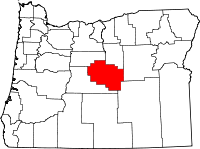
Location in the state of Oregon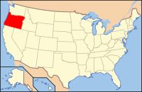
Oregon's location in the U.S.Founded October 24, 1882 Seat Prineville Area
- Total
- Land
- Water
2,987 sq mi (7,736 km²)
2,979 sq mi (7,716 km²)
8 sq mi (21 km²), 0.27%Population
- (2010)
- Density
20,978
7/sq mi (2.7/km²)Website www.co.crook.or.us Crook County is a county located in the U.S. state of Oregon. In 2010, its population was 20,978. It is named after George Crook, a U.S. Army officer who served in the American Civil War and various Indian Wars. The seat of the county is Prineville.
Contents
History
 Logging in the Ochoco Mountains, circa 1900
Access into the region at first was difficult, which discouraged settlement. The first effort to develop routes into the area was in 1862 when a supply train with cattle crossed the Scott Trail. This was also the first group of non-natives to spend the winter in central Oregon. The discovery and development of the Santiam Pass in the 1860s improved access into the area.
Crook County was formed from the southern part of Wasco County on October 24, 1882, and established Prineville as the county seat. The voters confirmed the choice of Prineville, the only incorporated town in the county, in the 1884 general election.
Logging in the Ochoco Mountains and the timber mills that accompanied it contributed to the economic and population growth of the county. The first recorded mention of a sawmill was made by George Barnes, speaking about the Swartz sawmill on Mill Creek, circa 1867.[1][2]
Economy
Forest products, agriculture, livestock raising and recreation/tourism services constitute Crook County's total economy. Agriculture is supported by the development of irrigation districts, which permits the raising of hay, grain, mint, potatoes, and seed. Range and forest lands allow grazing for a sizable livestock industry. The Ochoco National Forest's stand of ponderosa pine is the main source of lumber. As the lumber industry suffers from restrictions on log cutting, tourism and recreation are helping to strengthen the economy. Thousands of hunters, fishers, boaters, sightseers and rockhounds are annual visitors to its streams, reservoirs and the Ochoco Mountains. The Prineville Chamber of Commerce provides access to over 1,000 acres (4.0 km2) of mining claims to rockhounds, who can dig for free agates, limb casts, jasper and thundereggs.
Politics
Though Crook County is the most central county in Oregon, politically it falls in line with the eastern side of the state. The majority of registered voters who are part of a political party in Crook County, as well as most counties in eastern Oregon, are members of the Republican Party.[3] In the 2008 presidential election, 61.54% of Crook County voters voted for Republican John McCain, while 35.09% voted for Democrat Barack Obama and 3.37% of voters either voted for a third-party candidate or wrote in a candidate.[4] These numbers show a small shift towards the Democratic candidate when compared to the 2004 presidential election, in which 68% of Crook Country voters voted for George W. Bush, while 30.1% voted for John Kerry, and 1.9% of voters either voted for a third-party candidate or wrote in a candidate.[5]
Geography
The county is located in the geographic center of Oregon. It has a total area of 2,987 square miles (7,736.3 km2), of which 2,979 square miles (7,715.6 km2) is land and 8 square miles (20.7 km2) (0.27%) is water. The largest body of water in Crook County is the Prineville Reservoir. The county has been reduced from its original size of 8,600 square miles (22,000 km2) by the creation of Jefferson County in 1914 and Deschutes County in 1916. The present boundaries were established in 1927.
The oldest geological formation in Oregon is in the southeastern corner of Crook County, near its boundary with Grant County. This formation is an outcropping of Devonian limestone created from a larger reef when most of Oregon was covered by water.
Adjacent counties
- Deschutes County, Oregon - south, west
- Jefferson County, Oregon - north
- Wheeler County, Oregon - north
- Grant County, Oregon - east
- Harney County, Oregon - southeast

Jefferson County and Wheeler County Deschutes County 
Grant County  Crook County, Oregon

Deschutes County Harney County National protected area
- Ochoco National Forest (part)
Demographics
Historical populations Census Pop. %± 1890 3,244 — 1900 3,964 22.2% 1910 9,315 135.0% 1920 3,424 −63.2% 1930 3,336 −2.6% 1940 5,533 65.9% 1950 8,991 62.5% 1960 9,430 4.9% 1970 9,985 5.9% 1980 13,091 31.1% 1990 14,111 7.8% 2000 19,182 35.9% 2010 20,978 9.4% [6][7][8]  From 2000 to 2007, Crook County's population grew by 34.9%, more than three times the state average. It was the second fastest growing county in the state, after neighboring Deschutes County.
As of the census[9] of 2000, there were 19,182 people, 7,354 households, and 5,427 families residing in the county. The population density was 6 people per square mile (2/km²). There were 8,264 housing units at an average density of 3 per square mile (1/km²). The racial makeup of the county was 92.95% White, 0.04% Black or African American, 1.30% Native American, 0.43% Asian, 0.03% Pacific Islander, 3.81% from other races, and 1.43% from two or more races. 5.64% of the population were Hispanic or Latino of any race. 26.2% were of American, 14.8% German, 9.7% English and 8.9% Irish ancestry.
There were 7,354 households out of which 32.30% had children under the age of 18 living with them, 61.50% were married couples living together, 8.20% had a female householder with no husband present, and 26.20% were non-families. 21.30% of all households were made up of individuals and 9.50% had someone living alone who was 65 years of age or older. The average household size was 2.57 and the average family size was 2.96.
In the county, the population was spread out with 26.60% under the age of 18, 7.50% from 18 to 24, 25.50% from 25 to 44, 25.70% from 45 to 64, and 14.70% who were 65 years of age or older. The median age was 39 years. For every 100 females there were 99.40 males. For every 100 females age 18 and over, there were 97.30 males.
The median income for a household in the county was $35,186, and the median income for a family was $40,746. Males had a median income of $32,166 versus $22,580 for females. The per capita income for the county was $16,899. About 8.10% of families and 11.30% of the population were below the poverty line, including 13.90% of those under age 18 and 8.10% of those age 65 or over.
Communities
Incorporated city
Unincorporated communities
- Forest Crossing
- Lone Pine
- O'Neil
- Paulina
- Post
- Powell Butte
- Roberts
- Suplee
See also
References
- ^ Shaver, F. A., Arthur P. Rose, R. F. Steele, and A. E. Adams, compilers. An Illustrated History of Central Oregon: Embracing Wasco, Sherman, Gilliam, Wheeler, Crook, Lake, & Klamath Counties. Spokane, WA: Western Historical Publishing Co., 1905.
- ^ "Ponderosa Pine Capital of the World". digital collection, A. R. Bowman Memorial Museum. http://ponderosapinecapital.org.
- ^ a b State.or.us Retrieved on 4/20/09
- ^ Crook.or.us retrieved 4/20/09
- ^ City-data.com Retrieved on 4/21/09
- ^ http://www.census.gov/population/www/censusdata/cencounts/files/or190090.txt
- ^ http://factfinder2.census.gov
- ^ http://mapserver.lib.virginia.edu/
- ^ "American FactFinder". United States Census Bureau. http://factfinder.census.gov. Retrieved 2008-01-31.
Coordinates: 44°08′N 120°22′W / 44.13°N 120.36°W
Municipalities and communities of Crook County, Oregon City 
Communities Paulina | Post | Powell Butte
Categories:- Oregon counties
- Crook County, Oregon
- 1882 establishments


Wikimedia Foundation. 2010.