- Benton County, Oregon
-
Benton County, Oregon 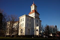
Benton County Courthouse in Corvallis 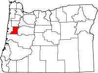
Location in the state of Oregon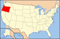
Oregon's location in the U.S.Founded 1847 Seat Corvallis Area
- Total
- Land
- Water
679 sq mi (1,759 km²)
676 sq mi (1,751 km²)
3 sq mi (8 km²), 0.37%Population
- (2010)
- Density
85,579
126/sq mi (48.8/km²)Website www.co.benton.or.us Benton County is a county located in the U.S. state of Oregon. The county was named after Thomas Hart Benton, a U.S. senator who advocated U.S. control over the Oregon Country. In 2010, the county's population was 85,579. It is coextensive with the Corvallis Metropolitan Statistical Area. Its county seat is Corvallis.
Contents
Economy
Along with Oregon State University, agriculture, lumber, wood products, and some printing technology research and development form the economic base of the county. A substantial portion of the nation's research in forestry, agriculture, engineering, education and the sciences takes place at OSU.
Geography
According to the U.S. Census Bureau, the county has a total area of 679 square miles (1,758.6 km2), of which 676 square miles (1,750.8 km2) is land and 3 square miles (7.8 km2) (0.37%) is water.
Adjacent counties
- Polk County, Oregon - (north)
- Lincoln County, Oregon - (west)
- Linn County, Oregon - (east)
- Lane County, Oregon - (south)

Polk County Lincoln County 
Linn County  Benton County, Oregon

Lane County National protected areas
Demographics
Historical populations Census Pop. %± 1850 814 — 1860 3,074 277.6% 1870 4,584 49.1% 1880 6,403 39.7% 1890 8,650 35.1% 1900 6,706 −22.5% 1910 10,663 59.0% 1920 13,744 28.9% 1930 16,555 20.5% 1940 18,629 12.5% 1950 31,570 69.5% 1960 39,165 24.1% 1970 53,776 37.3% 1980 68,211 26.8% 1990 70,811 3.8% 2000 78,153 10.4% 2010 85,579 9.5% As of the census[1] of 2000, there were 78,153 people, 30,145 households, and 18,237 families residing in the county. The population density was 116 people per square mile (45/km²). There were 31,980 housing units at an average density of 47 per square mile (18/km²). The racial makeup of the county was 89.16% White, 0.84% Black or African American, 0.79% Native American, 4.49% Asian, 0.24% Pacific Islander, 1.92% from other races, and 2.56% from two or more races. 4.66% of the population were Hispanic or Latino of any race. 18.2% were of German, 11.6% English, 8.9% Irish and 7.0% American ancestry. 91.1% spoke English, 4.1% Spanish and 1.0% Chinese as their first language.
There were 30,145 households out of which 28.40% had children under the age of 18 living with them, 50.40% were married couples living together, 7.20% had a female householder with no husband present, and 39.50% were non-families. 26.10% of all households were made up of individuals and 6.70% had someone living alone who was 65 years of age or older. The average household size was 2.43 and the average family size was 2.95.
In the county, the population was spread out with 21.30% under the age of 18, 20.20% from 18 to 24, 26.70% from 25 to 44, 21.40% from 45 to 64, and 10.30% who were 65 years of age or older. The median age was 31 years. For every 100 females there were 99.10 males. For every 100 females age 18 and over, there were 97.80 males.
The median income for a household in the county was $41,897, and the median income for a family was $56,319. Males had a median income of $42,018 versus $29,795 for females. The per capita income for the county was $21,868. About 6.80% of families and 14.60% of the population were below the poverty line, including 10.60% of those under age 18 and 4.90% of those age 65 or over.
Benton County has the lowest church attendance per capita of any county in the nation (25% attendance).[2]
History
Founding
Benton County was created from Polk County by an act of the Provisional Government of Oregon in 1847. The county was created out of an area originally inhabited by the Klickitat, who rented it from the Kalapuyas for use as hunting grounds. All Indian claims to land within Benton County were ceded in the Treaty of Dayton in 1855.
At that time, the boundaries began at the intersection of Polk County and the Willamette River, extended south as far as the California border and as far west as the Pacific Ocean. Later, portions of Benton County were taken to form Coos, Curry, Douglas, Jackson, Josephine, Lane and Lincoln Counties, leaving Benton County in its present form.
The city of Marysville, later renamed Corvallis, was made the county seat in 1851. In 1862 Corvallis became the site of the Oregon State Agricultural College, known today as Oregon State University.
Politics
The current Benton County Sheriff is Diana Simpson. She was elected on November 7, 2006 as the first woman sheriff of Benton County and the first elected female sheriff in Oregon.[citation needed]
Communities
Incorporated cities
 Lewisburg
- Adair Village
- Albany, (small portion, most in Linn County)
- Corvallis
- Monroe
- Philomath
Unincorporated communities
See also
References
- ^ "American FactFinder". United States Census Bureau. http://factfinder.census.gov. Retrieved 2008-01-31.
- ^ Reeves, Carol (2003-12-21). "Where are the faithful?". Corvallis Gazette-Times. http://www.gazettetimes.com/articles/2003/12/21/news/top_story/local01.txt. Retrieved 2006-06-11.
External links
Municipalities and communities of Benton County, Oregon Cities Adair Village | Albany‡ | Corvallis | Monroe | Philomath

Unincorporated
communitiesFootnotes ‡This populated place also has portions in an adjacent county or counties
Coordinates: 44°29′25″N 123°25′57″W / 44.49028°N 123.4325°W
Categories:- Oregon counties
- Benton County, Oregon
- 1847 establishments in the United States


Wikimedia Foundation. 2010.