- Baker County, Oregon
-
Baker County, Oregon 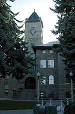
Baker County Courthouse in Baker City 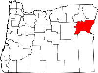
Location in the state of Oregon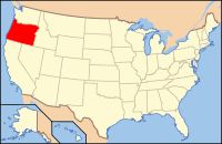
Oregon's location in the U.S.Founded September 22, 1862 Seat Baker City Area
- Total
- Land
- Water
3,088 sq mi (7,998 km²)
3,068 sq mi (7,946 km²)
20 sq mi (52 km²), 0.66%Population
- (2010)
- Density
16,134
5/sq mi (2/km²)Time zone Pacific: UTC-8/-7 Website www.bakercounty.org Baker County is a county located in the U.S. state of Oregon. It is included in the 8 county definition of Eastern Oregon. It is named for Edward Dickinson Baker, a senator from Oregon who was killed at Ball's Bluff, a battle of the Civil War in Virginia in 1861. It was split from the eastern part of Wasco County. Union County and Malheur County were set off from Baker County in 1864 and 1887 respectively. In 2010, its population was 16,134. The largest city and seat is Baker City.
Contents
History
The first groups from the eastern U.S. following the Oregon Trail passed through the area on their way to the Willamette Valley, unaware of the potential wealth they passed over. At Flagstaff Hill, near Baker City, 15 miles (24 km) of wagon ruts left by immigrants can still be seen.
In 1861 gold was discovered and Baker County became one of the Northwest's largest gold producers.
On September 22 of the following year, the state assembly created Baker County from the eastern part of Wasco County. Later, Union County and Malheur County were created from this county. The boundaries were adjusted for the last time in 1901, when the area between the Powder River and the Wallowa Mountains was returned to Baker County.
The original county seat was at Auburn. While at first a booming mining town with 5,000 inhabitants, once the gold was mined out Auburn's population dwindled, and county citizens eventually voted in 1868 to make Baker City, incorporated in 1874, the new county seat.
In 1914 Fern Hobbs, on behalf of her employer Governor Oswald West, declared martial law in the Baker County city of Copperfield. This was the first declaration of martial law in the state since the American Civil War.
Economy
Gold mining was the original impetus for settlement in the area, and at one time the county was the largest gold producer in the Northwest. Gold dredging was conducted with the Sumpter Valley Gold Dredge. With the exhaustion of the gold fields, agriculture, stock raising, logging became the primary economic pursuits. In the last decades of the 20th century, tourism also contributed to the local economy, helped by attractions that include the Eagle Cap Wilderness Area, the Hells Canyon National Recreation Area, and Anthony Lakes Ski Area. The National Historic Oregon Trail Interpretive Center has drawn numerous visitors since its opening in 1993.
Politics
Like all counties in eastern Oregon, the majority of registered voters who are part of a political party in Baker County are members of the Republican Party. In the 2008 presidential election, 64.37% of Baker County voters voted for Republican John McCain, while 31.95% voted for Democrat Barack Obama and 3.66% of voters either voted for a Third Party candidate or wrote in a candidate.[1] These numbers have changed slightly from the 2004 presidential election, in which 69.2% voted for George W. Bush, while 29% voted for John Kerry, and 1.8% of voters either voted for a Third Party candidate or wrote in a candidate.[2]
Geography
According to the U.S. Census Bureau, the county has a total area of 3,088 square miles (7,997.9 km2), of which 3,068 square miles (7,946.1 km2) is land and 20 square miles (51.8 km2) (0.66%) is water.
About 30% of the county is forest.
Adjacent counties
- Union County - (north)
- Wallowa County - (north)
- Grant County - (west)
- Malheur County - (south)
- Washington County, Idaho - (east)
- Adams County, Idaho - (northeast)
National protected areas
- Deer Flat National Wildlife Refuge (part)
- Hells Canyon National Recreation Area (part)
- Malheur National Forest (part)
- Whitman National Forest (part)
Demographics
Historical populations Census Pop. %± 1870 2,804 — 1880 4,616 64.6% 1890 6,764 46.5% 1900 15,597 130.6% 1910 18,076 15.9% 1920 17,929 −0.8% 1930 16,754 −6.6% 1940 18,297 9.2% 1950 16,175 −11.6% 1960 17,295 6.9% 1970 14,919 −13.7% 1980 16,134 8.1% 1990 15,317 −5.1% 2000 16,741 9.3% 2010 16,134 −3.6% sources:[4][5] As of the census[6] of 2000, there were 16,741 people, 6,883 households, and 4,680 families residing in the county. The population density was 6 people per square mile (2/km²). There were 8,402 housing units at an average density of 3 per square mile (1/km²). The racial makeup of the county was:
- 95.68% White
- 0.23% Black or African American
- 1.09% Native American
- 0.38% Asian
- 0.04% Pacific Islander
- 0.92% from other races
- 1.65% from two or more races.
2.34% of the population were Hispanic or Latino of any race. 18.4% were of English, 17.4% German, 11.4% American and 9.1% Irish ancestry.
There were 6,883 households out of which 28.00% had children under the age of 18 living with them, 56.20% were married couples living together, 8.60% had a female householder with no husband present, and 32.00% were non-families. 27.80% of all households were made up of individuals and 13.40% had someone living alone who was 65 years of age or older. The average household size was 2.37 and the average family size was 2.87.
In the county, the population dispersal was 24.20% under the age of 18, 5.80% from 18 to 24, 23.60% from 25 to 44, 27.30% from 45 to 64, and 19.00% who were 65 years of age or older. The median age was 43 years. For every 100 females there were 98.10 males. For every 100 females age 18 and over, there were 95.30 males.
The median income for a household in the county was $30,367, and the median income for a family was $36,106. Males had a median income of $27,133 versus $20,480 for females. The per capita income for the county was $15,612. About 10.10% of families and 14.70% of the population were below the poverty line, including 18.80% of those under age 18 and 12.40% of those age 65 or over.
Communities
Incorporated cities
- Baker City
- Greenhorn (considered a ghost town)
- Haines
- Halfway
Unincorporated communities
- Auburn
- Bridgeport
- Bourne
- Brownlee
- Carson
- China Town
- Clarksville
- Copperfield
- Cornucopia
- Durkee
- Encina
- Hereford
- Homestead
- Hutchinson
- Pine
- Pine Creek
- Pleasant Valley
- Pocahontas
- Robinette
- Rock Creek
- Rye Valley
See also
References
- ^ http://www1.bakercounty.org/EResults.nsf/electionresults11042008?OpenFrameset Retrieved on 4/21/09
- ^ http://www.city-data.com/county/Baker_County-OR.html Retrieved on 4/21/09
- ^ http://www.sos.state.or.us/elections/votreg/mar09.pdf Retrieved on 4/21/09
- ^ census.gov - Oregon population by county, 1900-90 - accessed 2009-05-02
- ^ http://factfinder2.census.gov
- ^ "American FactFinder". United States Census Bureau. http://factfinder.census.gov. Retrieved 2008-01-31.
Further reading
- Dielman, Gary (Spring 2008). "Discovering Gold in Baker County Library's Photograph Collection". Oregon Historical Quarterly 109 (1). http://www.historycooperative.org/journals/ohq/109.1/dielman.html.
External links
Municipalities and communities of Baker County, Oregon Cities Baker City | Greenhorn | Haines | Halfway | Huntington | Richland | Sumpter | Unity

Unincorporated
communitiesAuburn | Bridgeport | Carson | Copperfield | Cornucopia | Dixie | Durkee | Hereford | Homestead | Jimtown | Keating | Lime | Little Alps | McEwen | New Bridge | Oxbow | Pine | Pocahontas | Rock Creek | Salisbury | Sparta | Weatherby | Whitney | Wingville
Ghost towns Bourne | Robinette
Categories:- Oregon counties
- Baker County, Oregon
- 1862 establishments


Wikimedia Foundation. 2010.