- Osage County, Oklahoma
-
Osage County, Oklahoma 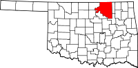
Location in the state of Oklahoma
Oklahoma's location in the U.S.Founded 1907 Seat Pawhuska Area
- Total
- Land
- Water
2,304 sq mi (5,967 km²)
2,251 sq mi (5,830 km²)
53 sq mi (137 km²), 2.30%Population
- (2010)
- Density
47,472
21/sq mi (8/km²)Osage County is a county in the northern part of the U.S. state of Oklahoma. Coterminous with the Osage Indian Reservation, it is the home of the federally recognized Osage Nation. As of the 2010 census, the population was 47,472 a 6.8 percent increase from 2000, when the population was 44,437.[1] Its county seat is Pawhuska.[2]
Contents
History
The Osage of Missouri increased their range to include the present Osage County by 1760. However, they surrendered their claim in 1825 to this land, which was included in a "perpetual outlet to the west given to the Cherokee Nation by the Treaty of New Echota" in 1835. In 1870, the Osage repurchased 1.57 million acres of this land from the Cherokees. This became the Osage Reservation in 1875, which became part of the Oklahoma Territory under the Organic Act of 1890. It became a semi-autonomous district by the Enabling Act of 1906 and Osage County at the time of Oklahoma Statehood. The Osage Agency was established at Deep Ford, later renamed as Pawhuska, in 1872.[3]
On December 26, 1861, a band of pro-Union Creeks and Seminoles fought with a Confederate Army unit at the Battle of Chustenahlah on Bird Creek, near the present town of Skiatook.[3]
In October 1897, the Pheonix Oil Company drilled the first successful oil well on the Osage reservation and Oklahoma Territory. It was located along Butler Creek. In 1901, Phoenix Oil and Osage Oil companies combined their assets to form the Indian Territory Illuminating Oil Company (ITIO), which sub-leased the eastern part of the Osage reservation until 1916. When ITIO's lease expired, 160-acre tracts were leased at public auctions.[3]
All subsurface minerals, including oil, are owned by the Osage tribe and held in trust for them by the Federal Government. Each mineral lease was negotiated by the Osage National Council and approved by the U. S. Secretary of the Interior.[3]
During the 1920s, Osage County was the site of the infamous Osage Indian murders.
Geography
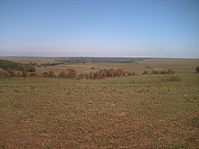 A view of Tallgrass Prairie Preserve inOsage County, Oklahoma
According to the U.S. Census Bureau, the county has a total area of 2,304 square miles (5,970 km2), the largest county in Oklahoma, of which 2,251 square miles (5,830 km2) is land and 53 square miles (140 km2) (2.30%) is water. Most of the county is in the Osage Plains, and consists of open prairie. The eastern part of the county contains the Osage Hills, an extension of the Flint Hills in Kansas.[3] Tallgrass Prairie Preserve is north of Pawhuska.
Gray Horse Creek, Drum Creek and Salt Creek all drain the southwestern part of the county and flow into the Arkansas River, which is part of the county's southern and western boundaries. Eastern Osage County drains into Caney River, Bird Creek, Hominy Creek, and Delaware Creek. All of these streams flow into the Verdigris River.[3]
Lakes and reservoirs in the county include:[3]
- Birch Lake
- Bluestem Lake
- Hulah Lake
- Kaw Lake
- Keystone Lake
- Skiatook Lake
It is the most populous and the second-largest geographically (to Corson County, South Dakota) of the six U.S. counties that lie entirely within an Indian reservation. (The six counties in descending order of area are Corson County; Osage County; Shannon County, South Dakota; Todd County, South Dakota; Sioux County, North Dakota; and Mahnomen County, Minnesota.) Three other counties, Thurston County, Nebraska; Dewey County, South Dakota and Ziebach County, South Dakota, lie entirely in parts of two separate Indian reservations, for a total of nine counties that lie entirely within reservation territory. Dewey County is also slightly larger than Osage County in area.
Demographics
As of the census[4] of 2000, there were 44,437 people, 16,617 households, and 12,213 families residing in the county. The population density was 20 people per square mile (8/km²). There were 18,826 housing units at an average density of 8 per square mile (3/km²). The racial makeup of the county was 67.01% White, 10.84% Black or African American, 14.42% Native American, 0.23% Asian, 0.03% Pacific Islander, 0.63% from other races, and 6.83% from two or more races. 2.12% of the population were Hispanic or Latino of any race.
There were 16,617 households out of which 33.20% had children under the age of 18 living with them, 59.40% were married couples living together, 10.30% had a female householder with no husband present, and 26.50% were non-families. 23.30% of all households were made up of individuals and 10.10% had someone living alone who was 65 years of age or older. The average household size was 2.58 and the average family size was 3.04.
In the county, the population was spread out with 26.40% under the age of 18, 7.70% from 18 to 24, 27.50% from 25 to 44, 25.40% from 45 to 64, and 13.10% who were 65 years of age or older. The median age was 38 years. For every 100 females there were 102.10 males. For every 100 females age 18 and over, there were 100.10 males.
The median income for a household in the county was $34,477, and the median income for a family was $40,784. Males had a median income of $31,148 versus $23,652 for females. The per capita income for the county was $17,014. About 10.30% of families and 13.20% of the population were below the poverty line, including 17.30% of those under age 18 and 12.10% of those age 65 or over.
Cities and towns
- Pawhuska
- Prue
- Sand Springs ††
- Shidler
- Skiatook †††
- † Bartlesville is primarily in Washington County, but part of it extends into Osage County.
- †† Sand Springs and Tulsa are primarily in Tulsa County, but parts of them extend into Osage County.
- ††† Skiatook is primarily in Osage County, but part of it extends into Tulsa County.
Census Designated Places (CDPs)
NRHP sites
The following sites in Osage County are listed on the National Register of Historic Places:
- Bank of Bigheart, Barnsdall
- Bank of Burbank, Burbank
- Bank of Hominy, Hominy
- Barnsdall Main Street Well Site, Barnsdall
- Blacksmith's House, Pawhuska
- Chapman-Barnard Ranch Headquarters, Pawhuska
- Chief Ne-Kah-Wah-She-Tun-Kah Grave and Statue, Fairfax
- Pawhuska City Hall, Pawhuska
- Fred Drummond House, Hominy
- First National Bank and Masonic Lodge, Fairfax
- Hominy Armory, Hominy
- Hominy Osage Round House, Hominy
- Hominy School, Hominy
- Immaculate Conception Church, Pawhuska
- Lincoln Colored School, Fairfax
- Marland Filling Station, Hominy
- Osage Agency, Pawhuska
- Osage Bank of Fairfax, Fairfax
- Osage County Courthouse, Pawhuska
- Pawhuska Armory, Pawhuska
- Pawhuska Downtown Historic District, Pawhuska
- Wolverine Oil Company Drayage Barn, Avant
Adjacent counties
- Cowley County, Kansas (north)
- Chautauqua County, Kansas (northeast)
- Washington County (east)
- Tulsa County (southeast)
- Pawnee County & Noble County (southwest)
- Kay County (west)
Popular culture
It is the setting of Oklahoma native Tracy Letts' play, August: Osage County (2007), which won the Pulitzer Prize for Drama and a Tony Award in 2008.
References
- ^ U. S.Census Bureau Osage County, Oklahoma.[1]
- ^ "Find a County". National Association of Counties. http://www.naco.org/Counties/Pages/FindACounty.aspx. Retrieved 2011-06-07.
- ^ a b c d e f g May, Jon D. Encyclopedia of Oklahoma History and Culture. "Osage County. Retrieved September 25, 2011.[2]
- ^ "American FactFinder". United States Census Bureau. http://factfinder.census.gov. Retrieved 2008-01-31.
See also
- August: Osage County (play)
Municipalities and communities of Osage County, Oklahoma Cities Barnsdall | Bartlesville‡ | Hominy | Pawhuska | Ponca City‡ | Sand Springs‡ | Shidler | Tulsa‡

Towns CDP Unincorporated
communitiesApperson | Bowring | Carter Nine | Gray Horse | Little Chief | Lynn Addition | McCord | Nelagony | Okesa | Pearsonia | Pershing | Tallant | Whippoorwill | Wild Horse | Wolco
Footnotes ‡This populated place also has portions in an adjacent county or counties
Categories:- Oklahoma counties
- Osage County, Oklahoma
- 1907 establishments in the United States
- Populated places established in 1907
- Tulsa Metropolitan Area


Wikimedia Foundation. 2010.