- Nowata County, Oklahoma
-
Nowata County, Oklahoma 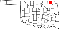
Location in the state of Oklahoma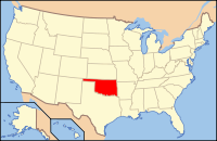
Oklahoma's location in the U.S.Founded 1907 Seat Nowata Area
- Total
- Land
- Water
581 sq mi (1,505 km²)
565 sq mi (1,463 km²)
16 sq mi (41 km²), 2.74%Population
- (2010)
- Density
10,573
18/sq mi (7/km²)Nowata County is a county located in the U.S. state of Oklahoma. As of the 2010 census, the population was 10,573, a decline of 0.3 percent from 2000, when the population was 10,569. Its county seat is Nowata[1].
Contents
History
The Encyclopedia of Oklahoma History and Culture states that archaeological evidence indicates that humans first lived in this area in the Verdigris River valley over six thousand years ago.[2]
In the 17th century, white trappers first visiting the area found it occupied mostly by the Osage and Quawpaw tribes. It was recognized as Osage territory by the time of the Louisiana Purchase. An 1828 treaty with the Cherokee Nation assigned the area of Nowata County to the Cherokees, who included it in 1856 in their newly created Cooweescoowee District. The Cherokees and the Delaware signed a treaty in 1867 that resulted in Delaware settlements near the present towns of Delaware, Lenapah and Nowata, Oklahoma.[2]
Nowata County was established in 1907,at Oklahoma statehood, with a population of 10,453. The town of Nowata was named as county seat.[2]
Geography
According to the U.S. Census Bureau, the county has a total area of 1,504 km² (581 mi²). 1,463 km² (565 mi²) of it is land and 41 km² (16 mi²) of it (2.74%) is water.
The Verdigris River divides the county into eastern and western halves. Creeks in the extreme eastern part of the county drain into the Caney River. All other creeks drain into the Verdigris River.[2] Lake Oologah lies partly in this county.
Major highways
 U.S. Highway 60
 U.S. Highway 169
 State Highway 10
 State Highway 28
Adjacent counties
- Montgomery County, Kansas (north)
- Labette County, Kansas (northeast)
- Craig County (east)
- Rogers County (south)
- Washington County (west)
Demographics
As of the census[3] of 2000, there were 10,569 people, 4,147 households, and 2,989 families residing in the county. The population density was 7/km² (19/mi²). There were 4,705 housing units at an average density of 3/km² (8/mi²). The racial makeup of the county was 72.43% White, 2.46% Black or African American, 16.56% Native American, 0.12% Asian, 0.26% from other races, and 8.17% from two or more races. 1.23% of the population were Hispanic or Latino of any race.
There were 4,147 households out of which 31.80% had children under the age of 18 living with them, 58.80% were married couples living together, 9.80% had a female householder with no husband present, and 27.90% were non-families. 25.50% of all households were made up of individuals and 13.30% had someone living alone who was 65 years of age or older. The average household size was 2.50 and the average family size was 2.97.
In the county, the population was spread out with 26.10% under the age of 18, 7.60% from 18 to 24, 25.30% from 25 to 44, 23.70% from 45 to 64, and 17.30% who were 65 years of age or older. The median age was 39 years. For every 100 females there were 96.70 males. For every 100 females age 18 and over, there were 93.20 males.
The median income for a household in the county was $29,470, and the median income for a family was $36,354. Males had a median income of $27,047 versus $19,371 for females. The per capita income for the county was $14,244. About 9.00% of families and 14.10% of the population were below the poverty line, including 18.00% of those under age 18 and 11.30% of those age 65 or over.
City and towns
NRHP sites
The followings sites in Nowata County are listed on the National Register of Historic Places:
- Cemetery Patent 110, Delaware
- Diamond Point School, Nowata
- Nowata County Courthouse, Nowata
References
- ^ "Find a County". National Association of Counties. http://www.naco.org/Counties/Pages/FindACounty.aspx. Retrieved 2011-06-07.
- ^ a b c d Cheatham, Gary L. Encyclopedia of Oklahoma History and Culture: "Nowata County." Retrieved October 1, 2011.[1]
- ^ "American FactFinder". United States Census Bureau. http://factfinder.census.gov. Retrieved 2008-01-31.
Municipalities and communities of Nowata County, Oklahoma City 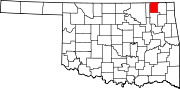
Towns Delaware | Lenapah | New Alluwe | South Coffeyville | Wann
Unincorporated
communitiesChilders | Watova
Ghost town Alluwe
Categories:- Oklahoma counties
- Nowata County, Oklahoma
- 1907 establishments in the United States
- Populated places established in 1907


Wikimedia Foundation. 2010.