- Bryan County, Oklahoma
-
Bryan County, Oklahoma 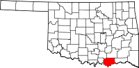
Location in the state of Oklahoma
Oklahoma's location in the U.S.Founded 1907 Seat Durant Largest city Durant Area
- Total
- Land
- Water
943 sq mi (2,443 km²)
909 sq mi (2,354 km²)
35 sq mi (90 km²), 3.67%Population
- (2000)
- Density
36,534
40/sq mi (16/km²)Time zone Central: UTC-6/-5 Bryan County is a county located in the U.S. state of Oklahoma. The population was 36,534 at the 2000 census. Its county seat is Durant.[1] The county shares the same boundaries as the Durant Micropolitan Area. It is also home to the headquarters of the Choctaw Nation of Oklahoma located in Durant. Bryan County consists of 10 Townships: Albany, Bennington, Bokchito, Brown, Caddo, Calera, Colbert, Kemp, Matoy, and Speairs Townships.[2] It is the only county in the United States named for Populist politician William Jennings Bryan.
Contents
Geography
According to the U.S. Census Bureau, the county has a total area of 943 square miles (2,442.4 km2), of which 909 square miles (2,354.3 km2) is land and 35 square miles (90.6 km2) (3.67%) is water.
Major highways
Adjacent counties
- Atoka County (north)
- Choctaw County (east)
- Lamar County, Texas (southeast)
- Fannin County, Texas (south)
- Grayson County, Texas (southwest)
- Marshall County (west)
- Johnston County (northwest)
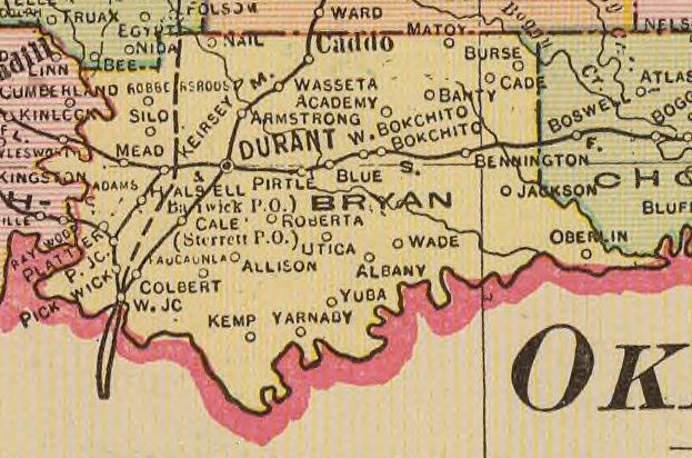
History
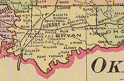 Map of Bryan County, 1909
After statehood Durant became the county seat of Bryan County after a vote.
Demographics
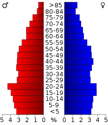 Age pyramid for Bryan County, Oklahoma, based on census 2000 data.
As of the census[3] of 2000, there were 36,534 people, 14,422 households, and 9,936 families residing in the county. The population density was 40 people per square mile (16/km²). There were 16,715 housing units at an average density of 18 per square mile (7/km²). The racial makeup of the county was 80.02% White, 1.42% Black or African American, 12.16% Native American, 0.44% Asian, 0.04% Pacific Islander, 1.08% from other races, and 4.84% from two or more races. 2.65% of the population were Hispanic or Latino of any race. 28.4% were of American, 10.1% Irish, 8.1% German and 6.7% English ancestry according to Census 2000.
There were 14,422 households out of which 30.40% had children under the age of 18 living with them, 54.00% were married couples living together, 10.80% had a female householder with no husband present, and 31.10% were non-families. 26.60% of all households were made up of individuals and 11.50% had someone living alone who was 65 years of age or older. The average household size was 2.47 and the average family size was 2.98.
In the county, the population was spread out with 24.80% under the age of 18, 11.70% from 18 to 24, 25.70% from 25 to 44, 22.30% from 45 to 64, and 15.40% who were 65 years of age or older. The median age was 36 years. For every 100 females there were 95.10 males. For every 100 females age 18 and over, there were 92.40 males.
The median income for a household in the county was $27,888, and the median income for a family was $33,984. Males had a median income of $26,831 versus $20,087 for females. The per capita income for the county was $14,217. About 14.00% of families and 18.40% of the population were below the poverty line, including 21.40% of those under age 18 and 17.00% of those age 65 or over.
Cities and towns
NRHP sites
The following sites in Bryan county are on the National Register of Historic Places.
- Bloomfield Academy Site, Achille vicinity
- Armstrong Academy Site, Bokchito vicinity
- Caddo Community Building, Caddo
- Colbert's Ferry Site, Colbert vicinity
- Bryan County Courthouse, Durant
- Robert E. Lee School, Durant
- Oklahoma Presbyterian College, Durant
- State Highway No. 78 Bridge at the Red River, Karma vicinity
- Robert Lee Williams Public Library, Durant
- J. L. Wilson Building, Durant
- Carriage Point (Fisher's Station), Durant
- Roberta School Campus, Durant
- Fort McCulloch, Kenefic vicinity
- Nail's Station, Kenefic vicinity
- Fort Washita, Nida vicinity
References
- ^ "Find a County". National Association of Counties. http://www.naco.org/Counties/Pages/FindACounty.aspx. Retrieved 2011-06-07.
- ^ Oklahoma Townships
- ^ "American FactFinder". United States Census Bureau. http://factfinder.census.gov. Retrieved 2008-01-31.
Further reading
- Bryan County Heritage Association. The History of Bryan County Oklahoma. National ShareGraphics, 1983. 596.
External links
Municipalities and communities of Bryan County, Oklahoma City 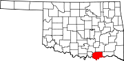
Towns Unincorporated
communitiesAlbany | Allison | Banty | Barry | Blue | Brown | Cade | Cartwright | Cobb | Kiersey | Lake West | Liberty | Matoy | Midland | New Oberlin | Oberlin | Platter | Pritchard | Romia | Roberta | Sand Point | Smith-Lee | Staley | Ury | Utica | Wade | Wasseta | Weeks | Yarnaby | Yuba
Ghost towns Adams | Barwick | Burse | Finchtown | Jackson | Hatsboro | New Allison | Olive | Pickwick | Pirtle | Paucaunla | Rock Springs | Westlake
National Register of Historic Places in Bryan County, Oklahoma Achille Bloomfield Academy Site

Bokchito Caddo Caddo Community Building
Colbert Durant Bryan County Courthouse · Durant Downtown Historic District · Robert E. Lee School · Oklahoma Presbyterian College · State Highway No. 78 Bridge at the Red River · Robert Lee Williams Public Library · J. L. Wilson Building · Carriage Point (Fisher's Station) · Roberta School Campus
Kenefic Fort McCulloch · Nail's Station
Nida Categories:- Oklahoma counties
- Bryan County, Oklahoma
- 1907 establishments in the United States
- Populated places established in 1907


Wikimedia Foundation. 2010.