- N2 road (Ireland)
-
N2 road
Location Primary
destinations:(bypassed routes in italics)
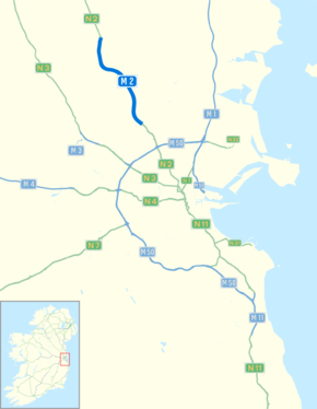
Road network The N2 road is a national primary road in Ireland, running from Dublin to the border with Northern Ireland at Moy Bridge near Aughnacloy, County Tyrone to connect Dublin with Derry via the A5. A section of the route near Dublin forms the M2 motorway.
Contents
Route
The N2 commences at a junction with the N1 along Dorset Street Upper. From here the route goes to Drumcondra, via St. Mary's Place, Western Way and the Phibsborough Road (and also in the opposite direction; North Circular Road, Berkeley Road, Berkeley Street and Blessington Street). The route leaves the city past Glasnevin via Prospect Road, and Finglas via the Finglas Road. The N2 meets the M50 motorway at Junction 5.
 N2 looking south from overbridge at Junction 2.
The N2 then runs as a dual-carriageway for 17km (10.5 miles) from the M50 to north of Ashbourne, County Meath. This project was opened on 25 May 2006, and includes 3.5km (2.2 miles) of three lane dual carriageway built to motorway standard. The route is the first to have a 120 km/h (75 mph) special speed limit (this was previously reserved for motorways, see Road speed limits in the Republic of Ireland for particulars). 13km (8.1 miles) of this dual carriageway stretch became motorway on 28 August 2009. (see M2 motorway).
The route continues through Balrath towards Slane, where a dangerous bridge brings the road through the town by the historic Hill of Slane, now home to the occasional rock festival. The N2 continues through Collon in County Louth. Just after Ardee the N2 meets the N33, which connects the N2 to the nearby M1 motorway. North of this, in County Monaghan, the N2 bypasses Carrickmacross to the east, along a bypass opened on 21 January 2005. This 9 km wide single carriageway has been named The Kavanagh Way, after Monaghan writer and poet Patrick Kavanagh. The route by-passes Castleblayney and Clontibret on the way to Monaghan. North of Monaghan town, the N12 diverges east to the border. The N2 continues north through Emyvale to reach the border at Moy Bridge directly south of Aughnacloy, County Tyrone. From here, the road becomes the A5 road to Omagh and Derry.
 N2 road Ashbourne bypass
Upgrades
Projects recently completed on the N2 include a 16km (10 miles) 2+1 bypass of Castleblayney, which opened on 5 November 2007 .[1] A 3km (1.9 miles) single carriageway bypass of Monaghan town to the east was opened on the 25 September 2006 by Pat Gallagher, Junior Minister For Transport.
Previous planned projects along the N2 included a 4km (2.5 miles) bypass of Ardee and a 6km (3.7 miles) bypass of Slane. These projects have now been incorporated into a single project which extends from the end of the Ashbourne Bypass to north of Ardee (N2 Ashbourne to Ardee)[2]. The feasibility report for this scheme recommends a dual carriageway cross section. That section of the N2 from the end of the Castleblayney Bypass to the NI Border at Aughnacloy is also being studied (N2 Clontibret to NI Border).
Discussion
There have been calls (by both Republic of Ireland and Northern Ireland political parties) to upgrade the whole Dublin–Derry route to dual carriageway, including the A5 in Northern Ireland. In October 2006, the Irish government announced it was funding infrastructure costing €1 billion in Northern Ireland, and one possible project to be funded is the upgrading of the A5 Derry–Omagh–Aughnacloy road to motorway standard for a distance of 88 km (55 mi). However, there was no mention of the N2 road being upgraded to motorway standard in the Republic.[3] The Irish Department of Finance website confirmed on 22 March 2007 that £400 million had been set aside for Northern investment to include a dual carriageway to Derry and Donegal. It was unclear if any of this would be built in the Republic.
The 2007 Fianna Fáil election policy document on transport includes a dual carriageway from Dublin to Letterkenny/Derry as one of Fianna Fáil's promises if re-elected. Although the N2 is not included in Transport 21 and the recently opened Monaghan and Carrickmacross by-passes are single lane national primary roads, a recent feasibility report completed on the N2 Ashbourne to Ardee section recommends a dual carriageway cross section (this includes the Slane By-pass). Also in order to tie in with the A5 Western Transport Corridor north of the border work on the feasibility study for the N2 Clontibret to NI Border Scheme has commenced.
Currently the National Roads Authority (NRA) encourages hauliers heading north to Derry to use the M1 as far as the N33 road to Ardee, avoiding the dangerous sections of the parallel N2 in the environs of Slane, Collon and Ardee.
M2 motorway
M2 motorway

 Clickable image
Route information Part of 
Length: 13 km (8 mi) Existed: 2004 – present History: Completed in 2006 Major junctions From: Killshane N2 Road network  Start of the motorway north of Ashbourne
 Northbound entrance to the motorway north of Kilshane
On 30 September 2008, it was announced that a 13km (8.1 miles) section of the current N2 from Killshane to Ashbourne was under consideration for re-designation to motorway standard. Public consultation finished in December 2008.[4]
On 14 July 2009, it was announced that the 13km (8.1 miles) stretch had received ministerial approval to be re-designated [5]. It became a motorway on 28 August 2009.
Junctions

Northbound exit Junction Southbound exit Start of high-quality dual carriageway 
Dublin Airport, Dublin Port and ALL OTHER ROUTES M50.
(Road continues as regular dual carriageway for Finglas and Dublin)Coldwinters — No exit 
St Margaret's, Blanchardstown 
St Margaret's, Blanchardstown Ashbourne (South), Ratoath, Swords R135 
Ashbourne (South), Ratoath, Swords R135 Ashbourne. 
Ashbourne N2 continues as regular national road for Derry — Start of motorway See also
- Roads in Ireland
- Motorways in Ireland
- National secondary road
- Regional road
References
- ^ "New N2 Castleblayney Bypass Opened". National Development Plan. 2007-11-05. http://www.ndp.ie/viewdoc.asp?DocID=1997. Retrieved 2009-03-31.
- ^ http://www.nra.ie/RoadSchemeActivity/MeathCountyCouncil/N2AshbournetoArdee/SchemeName,16476,en.html
- ^ Webster, Philip. "Article in The Times". London: The Times Online. http://www.timesonline.co.uk/newspaper/0,,2765-2415815_1,00.html.[dead link]
- ^ "Proposed Motorway Declarations of the Killshane to Ashbourne Section of the N2 (Dublin – Derry)" (PDF). Department of Transport (Ireland). 2009-09. p. 3. http://www.transport.ie/upload/general/10978-4.pdf. Retrieved 2009-03-31.
- ^ http://www.irishtimes.com/newspaper/ireland/2009/0714/1224250638091.html
- Roads Act 1993 (Classification of National Roads) Order 2006 – Department of Transport
- Official site of the N2 Ashbourne Bypass/M50 Junction project
- National Roads Authority (details of projects completed, under construction, and planned on the N2, and other routes)
Roads in Ireland Motorways National primary roads National secondary roads Regional roads (R101–R399) R101 · R102 · R103 · R104 · R105 · R106 · R107 · R108 · R109 · R110 · R111 · R112 · R113 · R114 · R115 · R116 · R117 · R118 · R119 · R120 · R121 · R122 · R123 · R124 · R125 · R126 · R127 · R128 · R129 · R130 · R131 · R132 · R133 · R134 · R135 · R136 · R148 · R149 · R150 · R151 · R152 · R153 · R154 · R155 · R156 · R157 · R158 · R159 · R160 · R161 · R162 · R163 · R164 · R165 · R166 · R167 · R168 · R169 · R170 · R171 · R172 · R173 · R174 · R175 · R176 · R177 · R178 · R179 · R180 · R181 · R182 · R183 · R184 · R185 · R186 · R187 · R188 · R189 · R190 · R191 · R192 · R193 · R194 · R195 · R196 · R197 · R198 · R199 · R200 · R201 · R202 · R203 · R204 · R205 · R206 · R207 · R208 · R209 · R210 · R211 · R212 · R213 · R214 · R229 · R230 · R231 · R232 · R233 · R234 · R235 · R236 · R237 · R238 · R239 · R240 · R241 · R242 · R243 · R244 · R245 · R246 · R247 · R248 · R249 · R250 · R251 · R252 · R253 · R254 · R255 · R256 · R257 · R258 · R259 · R260 · R261 · R262 · R263 · R264 · R265 · R266 · R267 · R268 · R277 · R278 · R279 · R280 · R281 · R282 · R283 · R284 · R285 · R286 · R287 · R288 · R289 · R290 · R291 · R292 · R293 · R294 · R295 · R296 · R297 · R298 · R299 · R310 · R311 · R312 · R313 · R314 · R315 · R316 · R317 · R318 · R319 · R320 · R321 · R322 · R323 · R324 · R325 · R326 · R327 · R328 · R329 · R330 · R331 · R332 · R333 · R334 · R335 · R336 · R337 · R338 · R339 · R340 · R341 · R342 · R343 · R344 · R345 · R346 · R347 · R348 · R349 · R350 · R351 · R352 · R353 · R355 · R356 · R357 · R358 · R359 · R360 · R361 · R362 · R363 · R364 · R365 · R366 · R367 · R368 · R369 · R370 · R371 · R372 · R373 · R374 · R375 · R376 · R377 · R378 · R379 · R389 · R390 · R391 · R392 · R393 · R394 · R395 · R396 · R397 · R398 · R399Regional roads (R400–R699) R400 · R401 · R402 · R403 · R404 · R405 · R406 · R407 · R408 · R409 · R410 · R411 · R412 · R413 · R414 · R415 · R416 · R417 · R418 · R419 · R420 · R421 · R422 · R423 · R424 · R425 · R426 · R427 · R428 · R429 · R430 · R431 · R432 · R433 · R434 · R435 · R436 · R437 · R438 · R439 · R440 · R441 · R442 · R443 · R444 · R445 · R446 · R448 · R449 · R458 · R459 · R460 · R461 · R462 · R463 · R464 · R465 · R466 · R467 · R468 · R469 · R470 · R471 · R472 · R473 · R474 · R475 · R476 · R477 · R478 · R479 · R480 · R481 · R482 · R483 · R484 · R485 · R486 · R487 · R488 · R489 · R490 · R491 · R492 · R493 · R494 · R495 · R496 · R497 · R498 · R499 · R500 · R501 · R502 · R503 · R504 · R505 · R506 · R507 · R509 · R510 · R511 · R512 · R513 · R514 · R515 · R516 · R517 · R518 · R519 · R520 · R521 · R522 · R523 · R524 · R525 · R526 · R527 · R548 · R549 · R550 · R551 · R552 · R553 · R554 · R555 · R556 · R557 · R558 · R559 · R560 · R561 · R563 · R564 · R565 · R566 · R567 · R568 · R569 · R570 · R571 · R572 · R573 · R574 · R575 · R576 · R577 · R578 · R579 · R580 · R581 · R582 · R583 · R584 · R585 · R586 · R587 · R588 · R589 · R590 · R591 · R592 · R593 · R594 · R595 · R596 · R597 · R598 · R599 · R600 · R601 · R602 · R603 · R604 · R605 · R606 · R607 · R608 · R609 · R610 · R611 · R612 · R613 · R614 · R615 · R616 · R617 · R618 · R619 · R620 · R621 · R622 · R623 · R624 · R626 · R627 · R628 · R629 · R630 · R631 · R632 · R633 · R634 · R635 · R637 · R638 · R639 · R659 · R660 · R661 · R662 · R663 · R664 · R665 · R666 · R667 · R668 · R669 · R670 · R671 · R672 · R673 · R674 · R675 · R676 · R677 · R678 · R679 · R680 · R681 · R682 · R683 · R684 · R685 · R686 · R687 · R688 · R689 · R690 · R691 · R692 · R693 · R694 · R695 · R696 · R697 · R698 · R699Regional roads (R700–R940) R700 · R701 · R702 · R703 · R704 · R705 · R706 · R707 · R708 · R709 · R710 · R724 · R725 · R726 · R727 · R729 · R730 · R731 · R733 · R734 · R735 · R736 · R737 · R738 · R739 · R740 · R741 · R742 · R743 · R744 · R745 · R746 · R747 · R748 · R749 · R750 · R751 · R752 · R753 · R754 · R755 · R756 · R757 · R758 · R759 · R760 · R761 · R762 · R763 · R764 · R765 · R766 · R767 · R768 · R769 · R770 · R772 · R773 · R774 · R801 · R802 · R803 · R804 · R805 · R806 · R807 · R808 · R809 · R810 · R811 · R812 · R813 · R814 · R815 · R816 · R817 · R818 · R819 · R820 · R821 · R822 · R824 · R825 · R826 · R827 · R828 · R829 · R830 · R831 · R833 · R834 · R835 · R836 · R837 · R838 · R839 · R840 · R841 · R842 · R843 · R846 · R847 · R848 · R849 · R851 · R852 · R853 · R854 · R855 · R857 · R858 · R859 · R860 · R863 · R864 · R865 · R866 · R867 · R868 · R870 · R871 · R873 · R874 · R875 · R876 · R877 · R880 · R883 · R884 · R885 · R886 · R887 · R888 · R889 · R890 · R891 · R895 · R896 · R898 · R899 · R900 · R901 · R902 · R903 · R904 · R906 · R907 · R908 · R909 · R910 · R911 · R913 · R914 · R915 · R916 · R917 · R918 · R919 · R920 · R921 · R922 · R923 · R924 · R925 · R926 · R927 · R928 · R929 · R930 · R931 · R932 · R933 · R934 · R935 · R936 · R937 · R940See also: National Development Plan · National Roads Authority · Local roads · Trunk roads Categories:- National primary roads in the Republic of Ireland
- Roads in County Dublin
- Roads in County Meath
- Roads in County Louth
- Roads in County Monaghan


Wikimedia Foundation. 2010.