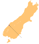
Lake McKerrow

Lake McKerrow
Lake McKerrow
Location Fiordland, Southland District, Southland Region, South Island
Coordinates 44°26′S 168°03′E / 44.433°S 168.05°E / -44.433; 168.05Coordinates: 44°26′S 168°03′E / 44.433°S 168.05°E / -44.433; 168.05
Primary inflows Hollyford River
Primary outflows Hollyford River
Basin countries New Zealand
Surface area 28 km²
Lake McKerrow

Lake McKerrow, also known by the Maori name of Whakatipu Waitai, lies at the northern end of Fiordland, in the southwest of New Zealand's South Island. The lake runs from southeast to northwest, is 15 kilometres in length, and covers 28 km².

Lake McKerrow drains, and is drained by, the Hollyford River. It is one of two lakes (along with Lake Alabaster) found in the lower reaches of the Hollyford River system, and the Hollyford Track, one of New Zealand's most well-known and popular tramping tracks, follows its eastern shore for its full length.

The lake is technically a fiord which has been cut off from the Tasman Sea by sediment. The sea is now three kilometres from the lake's northern end.


Wikimedia Foundation. 2010.

Игры ⚽ Поможем написать реферат

Look at other dictionaries:

  • Lake Alabaster — Infobox lake lake name = Lake Alabaster image lake = caption lake = image bathymetry = caption bathymetry = location = South Island coords = coord|44|31|S|168|10|E|region:NZ type:waterbody|display=inline,title type = inflow = Pyke River outflow …   Wikipedia

  • List of dual place names in New Zealand — The agreed dual name of Te Koko o Kupe / Cloudy Bay remembers both the Māori and British explorations of New Zealand. Many official place names in New Zealand are dual names, incorporating both the original Māori place names and the English names …   Wikipedia

  • Hollyford Track — it is unusual among Fiordland s major tracks in that it is largely flat and accessible year round.The track is 56 kilometres in length, and takes four days to walk one way. It runs roughly south north, its southern end being accessible by road 15 …   Wikipedia

  • Hollyford River — The Hollyford River is located in the southwest of the South Island of New Zealand. It runs for eighty miles in Fiordland, its source being ten kilometres to the north of the northern tip of Lake Te Anau and close to the Homer Tunnel.The river… …   Wikipedia

  • Jackson Bay — is a gently curving bay 24 kilometres wide, located on the West Coast of New Zealand s South Island. It faces the Tasman Sea to the north, and is backed by the Southern Alps. The westernmost point of the bay is marked by the headland of Jackson… …   Wikipedia

  • Jackson Bay (Bucht) — 43.9687146168.6795836 Koordinaten: 43° 58′ S, 168° 41′ O …   Deutsch Wikipedia

  • Альпийский разлом — Снег очерчивает уступы (куэсты), сформированные Альпийским разломом в северо западной части Южных Альп у западного побережья Южного острова …   Википедия

  • Ontario Highway 17 — Highway 17 Trans Canada Highway …   Wikipedia

  • Baldwin, Ontario — Baldwin   Township   Residential side street in McKerrow …   Wikipedia

  • Ontario Highway 6 — Highway 6 Garafraxa Road Route information …   Wikipedia

Share the article and excerpts

Direct link
Do a right-click on the link above
and select “Copy Link”