Shalbourne

Shalbourne

Coordinates: 51°23′N 1°33′W / 51.38°N 1.55°W / 51.38; -01.55

Shalbourne
Shalboune 1.JPG
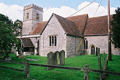
St. Michael and All Angels
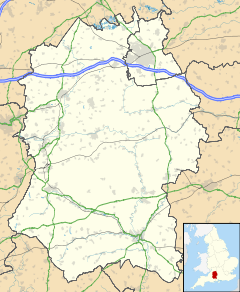
Shalbourne is located in Wiltshire
Shalbourne

 Shalbourne shown within Wiltshire
OS grid reference SU3165
Unitary authority Wiltshire
Ceremonial county Wiltshire
Region South West
Country England
Sovereign state United Kingdom
Police Wiltshire
Fire Wiltshire
Ambulance Great Western
EU Parliament South West England
List of places: UK • England • Wiltshire

Shalbourne is a civil parish in the English county of Wiltshire. Besides a village of the same name, the parish includes a number of widely spaced small settlements, including Bagshot and Stype, to the north, and Rivar and Oxenwood to the south. Before 1895, about half of the parish of Shalbourne (including its church) lay in Berkshire.

Contents

Location

Shalbourne is located at grid reference SU315630.

Local government

Shalbourne is a civil parish with an elected parish council. It also falls within the area of the Wiltshire Council unitary authority, which is responsible for all significant local government functions. In the 2001 census the parish had a population of 600.

Notable people

From 1608 until late 1637, tenants of the parish's Westcourt Manor included William Carpenter and his namesake son, both of whom emigrated to Weymouth, Massachusetts in 1638 on the Bevis from Southampton. The younger William Carpenter was a founder of Rehoboth, Massachusetts. The Rehoboth Carpenter family's descendants number in the tens of thousands, among whom are two U.S. presidents and a Project Mercury astronaut. William Carpenter [Jr.] married at Shalbourne in 1625 Abigail Briant, whose family had resided in the parish since at least the late 16th century.[1]

Sources

References

External links

Media related to Shalbourne at Wikimedia Commons


Wikimedia Foundation. 2010.

Игры ⚽ Нужно сделать НИР?

Look at other dictionaries:

  • Shalbourne — Original name in latin Shalbourne Name in other language Shalbourn, Shalbourne State code GB Continent/City Europe/London longitude 51.36358 latitude 1.55053 altitude 136 Population 0 Date 2011 07 31 …   Cities with a population over 1000 database

  • Rehoboth Carpenter family — The Rehoboth Carpenter Family was a historic American family from 1638 who helped to found the town of Rehoboth, Massachusetts. Savage in his A Genealogical Dictionary of The First Settlers of New England, Before 1692 traced the recorded origins… …   Wikipedia

  • Jethro Tull (agriculturist) — Infobox Person name = Jethro Tull image size = 210px caption = birth name = birth date = 30 March 1674 birth place = Basildon, Berkshire, England death date = death date and age|1741|02|21|1674|01|01 death place = Shalbourne, Berkshire, England… …   Wikipedia

  • Hungerford — For other uses, see: Hungerford (disambiguation) Coordinates: 51°24′52″N 1°30′53″W / 51.4144°N 1.5146°W / 51.4144; 1.5146 …   Wikipedia

  • Jethro Tull (Landwirtschaft) — Jethro Tull Jethro Tull (* Frühjahr 1674 in Basildon, Berkshire (England); † 21. Februar 1741 in Shalbourne, Berkshire) war ein englischer Agrar Pionier und wird als der Vater der Agrarwissenschaft erachtet. Er zeichnet für zahlreiche… …   Deutsch Wikipedia

  • Jethro Tull (agrónomo) — Este artículo o sección necesita referencias que aparezcan en una publicación acreditada, como revistas especializadas, monografías, prensa diaria o páginas de Internet fidedignas. Puedes añadirlas así o avisar …   Wikipedia Español

  • The Wurzels — Infobox musical artist | Name = The Wurzels Img capt = The Wurzels 2008. Img size = 2oo px Landscape = yes Background = group or band Alias = Origin = England Instrument = Genre = Scrumpy and Western Years active = 1966 present Label = Associated …   Wikipedia

  • Vale of Pewsey — The Vale of Pewsey is an area in the Kennet district of Wiltshire, England to the west of Devizes, centred on the town of Pewsey.GeographyThe vale is an extent of lower lying ground separating the chalk downs of Salisbury Plain to the south from… …   Wikipedia

  • George Frederick Bodley — Infobox Architect image size = (use only if image is smaller than 250px) caption = name =George Frederick Bodley nationality =English birth date =1827 birth place = death date =21 October 1907 death place =Water Eaton, Oxfordshire practice name …   Wikipedia

  • Wilton Windmill — The Wilton Windmill is a five floor brick tower mill located on a chalk ridge between the villages of Wilton and Great Bedwyn in the southern English county of Wiltshire. It was built in 1821 because the construction of the Kennet and Avon Canal… …   Wikipedia

Share the article and excerpts

Direct link
Do a right-click on the link above
and select “Copy Link”