Androy — ist die südlichste Region Madagaskars Androy ist eine der 25 Regionen Madagaskars. Es gehört zur Provinz Toliara im Süden der Insel. Es grenzt im Westen an Atsimo Andrefana und im Osten an Anosy. Inhaltsverzeichnis … Deutsch Wikipedia
Androy — is a region in Madagascar.*Capital: Ambovombe Androy *Chief: Andrien Hatrifenjanahary (since 2007)Androy is the most southern region of Madagascar. It is bordered by Atsimo Andrefana (West) and Anosy (East) … Wikipedia
Ambovombe — 25° 10′ 37″ S 46° 05′ 13″ E / 25.177, 46.087 … Wikipédia en Français
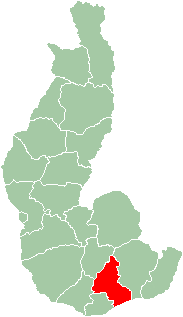
District d'Ambovombe — Ambovombe Ambovombe Androy Région Androy Chef lieu Ambovombe Nombre de kaominina 17 Superficie 5 829 … Wikipédia en Français
Androy — Localisation de la région d Androy à Madagascar. Androy est l une des vingt deux régions de Madagascar. Elle est située dans la province de Tuléar, dans le sud de l île. Sommaire … Wikipédia en Français
Ambohimalaza (Ambovombe) — 25° 15′ 00″ S 45° 56′ 00″ E / 25.25, 45.933333 … Wikipédia en Français
Ambohimalaza, Ambovombe — Infobox Settlement official name = Ambohimalaza other name = native name = nickname = settlement type = motto = imagesize = image caption = flag size = image seal size = image shield = shield size = image blank emblem = blank emblem type = blank… … Wikipedia
Districts of Madagascar — Districts are second level administrative divisions of Madagascar below the regions. Districts are in their turn divided into communes; while some of the districts on urban areas such as the district of Toliara consists of only one commune, most… … Wikipedia
Faritra — Régions de Madagascar Madagascar est divisée en 22 régions (faritra) : Population (estimation de 2004) [1] N° Région Capitale Population (hab.) Superficie (km²) Densité (hab./km²) Anciennes … Wikipédia en Français
Regions de Madagascar — Régions de Madagascar Madagascar est divisée en 22 régions (faritra) : Population (estimation de 2004) [1] N° Région Capitale Population (hab.) Superficie (km²) Densité (hab./km²) Anciennes … Wikipédia en Français