- Mercer County, North Dakota
-
Mercer County, North Dakota 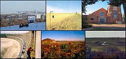 Cities of Mercer, left-to-right, up-to-down; Beulah, Golden Valley, Hazen, Pick City, Stanton, and Zap.
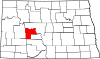
Location in the state of North Dakota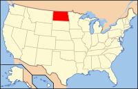
North Dakota's location in the U.S.Founded 1875 Seat Stanton Largest city Beulah Area
- Total
- Land
- Water
1,112 sq mi (2,880 km²)
1,045 sq mi (2,707 km²)
67 sq mi (174 km²), 6.02%Population
- (2010)
- Density
8,424
8/sq mi (3/km²)Website www.mercercountynd.com Mercer County is a county located in the U.S. state of North Dakota. As of 2010, the population was 8,424.[1] Its county seat is Stanton.[2]
The county was created by the 1874-1875 territorial legislature and was named for William Henry Harrison Mercer (1884–1901), an early rancher who settled north of Bismarck in 1869. The county government was first organized on August 4, 1884; Stanton has always been the county seat.[3]
Contents
Geography
According to the U.S. Census Bureau, the county has a total area of 1,112 square miles (2,880 km2), of which, 1,045 square miles (2,710 km2) of it is land and 67 square miles (170 km2) of it (6.02%) is water.
Adjacent counties
- McLean County (north)
- Oliver County (east)
- Morton County (south)
- Stark County (southwest)
- Dunn County (west)

McLean County Dunn County 
Oliver County  Mercer County, North Dakota

Stark County Morton County Major highways
 North Dakota Highway 31
 North Dakota Highway 48
 North Dakota Highway 49
 North Dakota Highway 200
 North Dakota Highway 1806
National protected area
Demographics
Historical populations Census Pop. %± 1890 428 — 1900 1,778 315.4% 1910 4,747 167.0% 1920 8,224 73.2% 1930 9,516 15.7% 1940 9,611 1.0% 1950 8,686 −9.6% 1960 6,805 −21.7% 1970 6,175 −9.3% 1980 9,404 52.3% 1990 9,808 4.3% 2000 8,644 −11.9% 2010 8,424 −2.5% U.S. Decennial Census As of the census[4] of 2000, there were 8,644 people, 3,346 households, and 2,445 families residing in the county. The population density was 8 people per square mile (3/km²). There were 4,402 housing units at an average density of 4 per square mile (2/km²). The racial makeup of the county was 96.04% White, 0.05% Black or African American, 2.00% Native American, 0.25% Asian, 0.38% Pacific Islander, 0.12% from other races, and 1.16% from two or more races. 0.37% of the population were Hispanic or Latino of any race. 68.8% were of German and 8.2% Norwegian ancestry according to Census 2000.
There were 3,346 households out of which 37.10% had children under the age of 18 living with them, 65.20% were married couples living together, 5.10% had a female householder with no husband present, and 26.90% were non-families. 24.80% of all households were made up of individuals and 11.10% had someone living alone who was 65 years of age or older. The average household size was 2.55 and the average family size was 3.05.
In the county the population was spread out with 29.10% under the age of 18, 4.20% from 18 to 24, 27.50% from 25 to 44, 24.90% from 45 to 64, and 14.30% who were 65 years of age or older. The median age was 40 years. For every 100 females there were 101.20 males. For every 100 females age 18 and over, there were 99.90 males.
The median income for a household in the county was $42,269, and the median income for a family was $51,983. Males had a median income of $47,969 versus $21,667 for females. The per capita income for the county was $18,256. About 5.50% of families and 7.50% of the population were below the poverty line, including 5.20% of those under age 18 and 20.90% of those age 65 or over.
Places
Cities
Note: all incorporated communities in North Dakota are called "cities" regardless of their size.
See also
References
- ^ "2010 Census Redistricting Data (Public Law 94-171) Summary File". American FactFinder. United States Census Bureau. http://factfinder2.census.gov/faces/tableservices/jsf/pages/productview.xhtml?pid=DEC_10_PL_GCTPL2.ST05&prodType=table. Retrieved 3 May 2011.
- ^ "Find a County". National Association of Counties. http://www.naco.org/Counties/Pages/FindACounty.aspx. Retrieved 2011-06-07.
- ^ "County History". Official Portal for North Dakota State Government. http://www.nd.gov/content.htm?parentCatID=83&id=County%20History. Retrieved 4 May 2011.
- ^ "American FactFinder". United States Census Bureau. http://factfinder.census.gov. Retrieved 2008-01-31.
Municipalities and communities of Mercer County, North Dakota Cities 
Unorganized
territoriesEast Mercer | Fort Berthold | West Mercer
Unincorporated
communityTruax
Categories:- North Dakota counties
- Mercer County, North Dakota
- North Dakota counties on the Missouri River


Wikimedia Foundation. 2010.