- Palilula, Belgrade
Infobox Settlement
official_name = Palilula
other_name =
native_name = Палилула
nickname =
settlement_type = Municipality
motto =
imagesize =
image_caption =
flag_size =
image_
seal_size =
image_shield = Palilula coa.jpg
shield_size =
image_blank_emblem =
blank_emblem_type =
blank_emblem_size =
mapsize = 100px
map_caption = Location within the City of Belgrade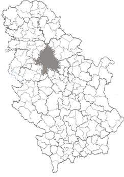
mapsize1 = 100px
map_caption1 = Location within Serbia
image_dot_
dot_mapsize =
dot_map_caption =
dot_x = |dot_y =
pushpin_
pushpin_label_position =
pushpin_map_caption =
pushpin_mapsize =
subdivision_type = Country
subdivision_name =Serbia
subdivision_type1 = City
subdivision_name1 =Belgrade
subdivision_type2 = Status
subdivision_name2 = Urban
subdivision_type3 = Settlements
subdivision_name3 = 8
subdivision_type4 =
subdivision_name4 =
government_footnotes =
government_type =Municipality of Belgrade
leader_title =Mun. president
leader_name =Danilo Bašić (DS)
leader_title1 =
leader_name1 =
leader_title2 =
leader_name2 =
leader_title3 =
leader_name3 =
leader_title4 =
leader_name4 =
established_title =
established_date =
established_title2 =
established_date2 =
established_title3 =
established_date3 =
area_magnitude =
unit_pref =
area_footnotes =
area_total_km2 =
area_land_km2 =
area_water_km2 =
area_total_sq_mi =
area_land_sq_mi =
area_water_sq_mi =
area_water_percent =
area_urban_km2 =
area_urban_sq_mi =
area_metro_km2 =
area_metro_sq_mi =
area_blank1_title =
area_blank1_km2 =
area_blank1_sq_mi =
population_as_of =2002
population_footnotes =
population_note =
population_total =155902
population_density_km2 =
population_density_sq_mi =
population_metro =
population_density_metro_km2 =
population_density_metro_sq_mi =
population_urban =
population_density_urban_km2 =
population_density_urban_sq_mi =
population_blank1_title =
population_blank1 =
population_density_blank1_km2 =
population_density_blank1_sq_mi =
timezone = CET
utc_offset = +1
timezone_DST =CEST
utc_offset_DST = +2
latd= |latm= |lats= |latNS=
longd= |longm= |longs= |longEW=
elevation_footnotes =
elevation_m =
elevation_ft =
postal_code_type = Postal code
postal_code =11000
area_code =+381 11
blank_name =Car plates
blank_info =BG
blank1_name =
blank1_info =
website = [http://www.palilula.org.yu/ http://www.palilula.org.yu/]
footnotes =Palilula (Serbian: Палилула) is an urban neighborhood and one of 17 municipalities which constitute the City of Belgrade, the capital of
Serbia . It is one of the 10 urban municipalities, but among them also one of 4 that have both urban and suburban sections. It has the largest area of all municipalities of Belgrade.Neighborhood
Location
Palilula is located east of
Terazije in downtown Belgrade. Like majority of Belgrade's neighborhoods it has no firm boundaries and is roughly bordered by the "Ruzveltova street" and the municipality and neighborhood ofZvezdara on the east, neighborhood ofHadžipopovac in its own municipality on the north, neighborhood and municipality of Stari Grad andJevremovac on the northwest (Jevremovac actually belongs to the neighborhood of Palilula, but administratively is part of Stari Grad), and theTašmajdan and the "King Alexander Boulevard" on the south, bordering with the municipality ofVračar . Several small local communities which make this area had the combined population of 14,896 in 2002.History
The neighborhood originates from the first half of the XVIII century, when
Habsburg Monarchy occupied northern Serbia 1717-1739. The settlement, built as an outer suburb of Belgrade, was originally named "Karlstadt" and was well known for agriculture and craftsmanship of its inhabitants. In the early XIX century, Palilula becomes overwhelmingly populated by theSerbs . In 1840 villagers of Palilula rejected the regulatory plan of Belgrade, on basis that projected new streets would be too wide, and later even tried to split from the municipality of Belgrade because of the city government's low funding for the village. However, in the late XIX century Palilula became part of the continuously built-up area of Belgrade. The neighborhood is almost entirely residential, with lots of commercial facilities being so close to the center of Belgrade.Name
The name "Palilula" comes from the expression "pali lulu" which in English means "light a
smoking pipe ". One anecdote goes back to times when Belgrade and Serbia were occupied by theOttoman Empire and Palilula used to be the area where most crops were so Turkish rulers banned smoking due to few instances of "accidental" setting of crops on fire. In the late summer and early autumn when all crops have been picked up, smoking ban was lifted and locals were announcing this by calling neighbours and letting them know that pipes may be lit. Another explanation comes from period of princeMiloš Obrenović 's rule who banned smoking in Belgrade so you could only smoke outside the city gates.Municipality
Location
Municipality of Palilula is generally located north of Belgrade. It is the northernmost of all Belgrade's municipalities and the easternmost of all urban municipalities. It is located on both banks of the
Danube , which divides it in two:Šumadija section (on the right bank) andBanat section (on the left bank).Šumadija section borders the municipalities of Stari Grad to the west, Vračar and Zvezdara to the south and
Grocka to the extreme southeast. It also has a river border on the Danube to the province ofVojvodina (Municipality ofPančevo ).Banat section has no land borders to the other Belgrade municipalities, but has a river border on the Danube to the municipalities of
Zemun and Stari Grad. Danube also makes the complete western border to the rest of theSyrmia region in Vojvodina (municipality ofStara Pazova ), while the riverTamiš makes the eastern border (municipalities of Pančevo andOpovo ). On the extreme north, Palilula borders the municipality ofZrenjanin (village ofČenta on the "Karaš" canal which connects the Danube and the Tamiš).Geography
Šumadija section marks the northernmost point of Šumadija with
Karaburma headland piking into the Danube. The prominent features in this part are the hills of Karaburma and "Milićevo brdo", the spa ofVišnjička Banja and the peninsula (formerly an island)Ada Huja .Banat section is the extreme southwestern part of Banat region, known as
Pančevački Rit . A km2 to mi2|400|abbr=yes large flat marshyfloodplain of the Danube and Tamiš, it has been drained since 1945 but still holds many features of a swamp, including slow, meandering and flooding streams (Vizelj , Mokri Sebeš, "Jojkićev Dunavac", "Dunavac", etc) and marshy bogs (Sebeš,Veliko Blato ,Široka Bara ). An island ofKožara is located on the Danube, and is projected starting point of the future much larger artificial island ofČaplja . The spa of Ovčanska Banja is also located here. The area close to the Danube is heavily forested.History
The municipality was created in 1956. On
January 3 ,1957 the municipality of Karaburma was annexed to it, while in 1965 the municipality of Krnjača (with entire Pančevački Rit) also administratively joined Palilula.Presidents of the municipal assembly:
* 1997 - 2000; Gordana Todić (1955)
* 2000 -October 21 ,2004 ; Milan Marković (1970)
*October 21 ,2004 - present; Danilo Bašić (1973)Dunavski Venac and Čenta
The motion of separating the area of former municipality of Krnjača start gaining momentum in the 2000s, this time under the name of
Dunavski Venac . As procedure by the city statute provides that municipal assembly (in this case, of Palilula) needs to start the motion in the city assembly, after years of public agitation, the municipal assembly of Palilula agreed to do so in summer 2005, but it still didn't officially did so, so the organization for separation of Dunavski Venac announced it will go to the court.The village of Čenta in the Vojvodina's municipality of Zrenjanin is located on the northern border of the municipality of Palilula. Now and then, a motions by the locals, not very vocal though, appear, asking for Čenta to be annexed to the City of Belgrade. Majority of population work on the territory of Belgrade and until recently, one regular bus line of Belgrade City public transportation was connecting Čenta to Belgrade.
Population
With an estimated population of 157,924 on
December 31 ,2005 (155,902 according to the last census 2002), Palilula is the third most populous municipality of Belgrade (afterNovi Beograd andČukarica ), but the growth of population, as in the rest of Belgrade, is slowing down. The major gainer of population in the municipality is still the suburb ofBorča . Population of Palilula:* 1961 - 89,141
* 1971 – 126,380 (census)
* 1981 – 150,484 (census)
* 1991 – 150,208 (census)
* 2002 – 155,902 (census)
* 2005 – 157,924 (estimate)Ethnic structure
According to the 2002 Census of population:
*
Serbs = 135,586 (86.97%)
* Roma = 3,897 (2.50%)
*Yugoslavs = 2,279 (1.46%)
*Montenegrins = 1,858 (1.19%)
* Macedonians = 1,035 (0.66%)
*Croats = 931 (0.59%)
*Gorani = 836 (0.53%)
* Muslims = 823 (0.52%)
*Romanians = 781 (0.50%)Neighborhoods and settlements
Neighborhoods of urban Palilula on the right bank of the Danube:
"Neighborhoods of Borča:"
"Neighborhoods of Padinska Skela:"
Economy
Industry and adjoining economic activities are located mostly along the right bank of the Danube. It includes the highy industrialized neighborhoods of Viline Vode (TEMPO cash-and-carry center, several gravel and sand extracting companies on the Danube's bank, Beograd put, Centroprom, Martez, Tehnohemija, Jugopapir, Duga, Avala cardboard factory, Balkan, eastern part of the port Belgrade and the railway station Beograd-Dunav) and Ada Huja (hangars and companies for building and construction, including a series of concrete plants and gravel and aggregates storing and treating facilities, paper and cardboard factory Avala-Ada, furniture factory Novi Dom, gravel storages of Tembo and DV Trade, etc). It also includes a series of brickworks which occupy extensive areas of the northern ridge of the Field of Višnjica (Polet, Trudbenik, Jedinstvo, Kozara, Balkan, Rekord). There is also extensive industrial zone in Krnjača and agricultural industry in Padinska Skela.
Palilula is crisscrossed by some of the major railroads in Belgrade area: "Zrenjaninski put", "Pančevački put", "Višnjička street", "Slanački put", etc. The only Belgrade's bridge over the Danube,
Pančevo Bridge (with railway) is located in Palilula.Intensive agrucultural production is developed in Banat section and eastern areas around Veliko Selo, producing large amounts of food (grains, fruits, vegetables, dairy products, etc) for the population of Belgrade. Palilula has the largest agricultural area of all municipalities of Belgrade. It covers an area of 298
square kilometers , or 66,5 % of the entire municipal territory. [Citation | last = | first = | author-link = Daliborka Mučibabić | title = Srpska prestonica u brojkama | newspaper =Politika | pages = p. 30 | language = Serbian | year = 2008 | date =2008-04-26 | url = ]Culture, education and sports
Urban Palilula hosts some of the most important faculties within the
Belgrade University : the Technical Faculty, the Faculty of Law and the Mining and Geology Faculty. Also, the building ofRadio Television of Serbia ,St. Mark's Church , Tašmajdan Park, sportsPionir Hall and the stadium of theOFK Belgrade soccer team are located in the municipality.Tourism
The beach of Bela Stena, and spas of Višnjička Banja and Ovčanska Banja are not used or developed enough. Belgrade's largest
kart racing track is located in Ada Huja. Future artificial island ofČaplja on the Danube is projected as the modern entertainment park, with aqua parks, golf courses, etc.International cooperation
Palilula is twinned with following cities and municipalities [ [http://www.skgo.org/php/opstine/detalji.php?Id=44&IdSvojstva=MO] "Stalna konferencija gradova i opština". Retrieved on
2007-06-18 .] :
*flagicon|GreeceFaiakes ,Greece ee also
*
Subdivisions of Belgrade
*List of Belgrade neighborhoods and suburbs References
External links
* [http://www.palilula.org.yu Palilula Municipality Official Site]
Wikimedia Foundation. 2010.