- Currituck County, North Carolina
-
Currituck County, North Carolina 
Seal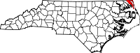
Location in the state of North Carolina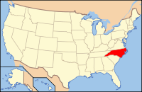
North Carolina's location in the U.S.Founded 1668 Seat Currituck Area
- Total
- Land
- Water
526 sq mi (1,362 km²)
262 sq mi (679 km²)
264 sq mi (684 km²), 50.21%Population
- (2010)
- Density
23,547
70/sq mi (27/km²)Website www.co.currituck.nc.us Currituck County is a county located in the U.S. state of North Carolina with its county seat at Currituck.[1] The county is part of the Hampton Roads metropolitan area based around Norfolk, Virginia.
Currituck was formed in 1668 as a precinct of Albemarle County. The name is "traditionally said to be an Indian word for wild geese; Coratank." It is in the northeastern section of the State and is bounded by the Atlantic Ocean, Currituck Sound, Camden County, Dare County and the state of Virginia. The present land area is 261.7 square miles (678 km2) and the 2000 population was 18,190.[2] Currituck Court House, mentioned as early as 1755, was the name of the county seat. Today the words "Court House" have been dropped and only Currituck is used as the town name.
Currituck is the 72nd fastest growing county in the United States according to a report by the U.S. Census Bureau.[3]
Contents
Law and government
Currituck County is a member of the Albemarle Commission regional council of governments.
The county is run by elected county commissioners.
Education
- Currituck County Schools are governed by a five-member, elected Board of Education.
- Central Elementary School
- Currituck County High School
- Currutuck County Middle School
- J.P. Knapp Early College High School
- Jarvisburg Elementary School
- Knotts Island Elementary School
- Moyock Elementary School
- Moyock Middle School
- Shawboro Elementary School
- W.T. Griggs Elementary School
Geography
 Pine trees are common in Currituck County, like these in Mackay Island National Wildlife Refuge.
According to the U.S. Census Bureau, the county has a total area of 526 square miles (1,362.3 km2), of which 262 square miles (678.6 km2) is land and 264 square miles (683.8 km2) (50.21%) is water (including Currituck Sound).
Currituck County includes the northern communities of North Carolina's Outer Banks, separated from mainland Currituck County by the Currituck Sound. The construction of a Mid-Currituck Bridge[4] is being discussed as a way to directly connect mainland Currituck County with the Outer Banks communities.
Adjacent counties and cities
- Chesapeake, Virginia (north)
- Virginia Beach, Virginia (north)
- Dare County, North Carolina (southeast)
- Camden County, North Carolina (west)

Chesapeake, Virginia and Virginia Beach, Virginia Camden County 
Atlantic Ocean  Currituck County, North Carolina

Dare County National protected areas
- Currituck National Wildlife Refuge
- Mackay Island National Wildlife Refuge (part)
Demographics
As of the census[5] of 2010, there were 23,547 people, 6,902 households, and 5,204 families residing in the county. The population density was 70 people per square mile (27/km²). There were 10,687 housing units at an average density of 41 per square mile (16/km²). The racial makeup of the county was 90.3% White, 5.8% Black or African American, 0.5% Native American, 0.6% Asian, 0.0% Pacific Islander, 0.9% from other races, and 1.8% from two or more races. 3.0% of the population were Hispanics or Latinos of any race.
There were 6,902 households out of which 33.60% had children under the age of 18 living with them, 61.60% were married couples living together, 9.20% had a female householder with no husband present, and 24.60% were non-families. 19.40% of all households were made up of individuals and 7.60% had someone living alone who was 65 years of age or older. The average household size was 2.61 and the average family size was 2.98.
The age distribution was 25.30% under the age of 18, 6.70% from 18 to 24, 30.50% from 25 to 44, 25.40% from 45 to 64, and 12.00% who were 65 years of age or older. The median age was 38 years. For every 100 females there were 98.60 males. For every 100 females age 18 and over, there were 97.50 males.
The median income for a household in the county was $40,822, and the median income for a family was $46,382. Males had a median income of $32,619 versus $22,641 for females. The per capita income for the county was $19,908. 10.70% of the population and 8.90% of families were below the poverty line. Out of the total people living in poverty, 16.10% are under the age of 18 and 8.90% are 65 or older.
Settlements
 Map of Currituck County, North Carolina With Municipal and Township Labels
- Aydlett
- Barco
- Carova Beach
- Coinjock
- Corolla
- Currituck
- Grandy
- Gregory
- Harbinger
- Knotts Island
- Jarvisburg
- Mamie
- Maple
- Moyock
- Point Harbor
- Poplar Beach
- Poplar Branch
- Powells Point
- Sanderling
- Shawboro
- Sligo
- Spot
- Waterlily
Notable people
- Dennis Anderson, best known as the driver of the Grave Digger monster truck.
- Ryan Anderson, best known as the driver of the Son Uva Digger monster truck.
See also
References
- ^ "Find a County". National Association of Counties. http://www.naco.org/Counties/Pages/FindACounty.aspx. Retrieved 2011-06-07.
- ^ "US Census Fact Sheet". http://factfinder.census.gov/servlet/SAFFFacts?_event=Search&geo_id=&_geoContext=&_street=&_county=currituck+county&_cityTown=currituck+county&_state=&_zip=&_lang=en&_sse=on&pctxt=fph&pgsl=010&show_2003_tab=&redirect=Y. Retrieved 2006-11-26.
- ^ Currituck County, NC Government - More Currituck County News
- ^ "Build The Bridge". http://www.buildthebridge.org/. Retrieved 2006-11-26.
- ^ "American FactFinder". United States Census Bureau. http://factfinder.census.gov. Retrieved 2008-01-31.
External links
- Currituck County Government website
- Currituck County Department of Travel and Tourism
- The Independent, local newspaper
Municipalities and communities of Currituck County, North Carolina County seat: Currituck Unincorporated
communitiesBarco | Carova Beach | Coinjock | Corolla | Currituck | Grandy | Gregory | Harbinger | Knotts Island | Jarvisburg | Mamie | Maple | Moyock | Point Harbor | Poplar Beach | Poplar Branch | Powells Point | Sanderling | Shawboro | Sligo | Spot | Waterlily

Hampton Roads Virginia Beach-Norfolk-Newport News Metropolitan Area Major Cities Chesapeake · Hampton · Newport News · Norfolk · Portsmouth · Suffolk · Virginia Beach
Counties Currituck · Gloucester · Isle of Wight · James City · Mathews · Surry · York
Other cities Towns Claremont · Dendron · Smithfield · Surry · Windsor
Sub-regions Topics Transportation · People · History · Battle of Hampton Roads ·
Note: Italic indicates independent city not part of any county The Outer Banks of North Carolina Landforms Places Currituck County · Dare County · Hyde County · Carteret County
Carova Beach · Corolla · Duck · Southern Shores · Kitty Hawk · Kill Devil Hills · Nags Head · Manteo · Wanchese · Rodanthe · Waves · Salvo · Avon · Buxton · Frisco · Hatteras · Ocracoke · PortsmouthWaterways Lighthouses Protected areas Transportation History Categories:- North Carolina counties
- Currituck County, North Carolina


Wikimedia Foundation. 2010.