- Cherokee County, North Carolina
-
Cherokee County, North Carolina 

Seal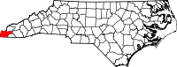
Location in the state of North Carolina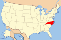
North Carolina's location in the U.S.Founded 1839 Seat Murphy Area
- Total
- Land
- Water
467 sq mi (1,210 km²)
455 sq mi (1,178 km²)
11 sq mi (28 km²), 2.46%Population
- (2000)
- Density
24,298
54/sq mi (21/km²)Website www.cherokeecounty-nc.gov Cherokee County is a county located in the U.S. state of North Carolina. As of 2000, the population was 24,298. Its county seat is Murphy[1].
Contents
History
The county was formed in 1839 from the western part of Macon County. It was named for the Cherokee people, some of whom still live in the area.
In 1861 the southeastern part of Cherokee County became Clay County; in 1872 its northeastern part became Graham County.
Law and government
Cherokee County is a member of the regional Southwestern Commission council of governments.
Geography
According to the U.S. Census Bureau, the county has a total area of 467 square miles (1,209.5 km2), of which 455 square miles (1,178.4 km2) is land and 11 square miles (28.5 km2) (2.46%) is water.
Natural Landscape
Located in the southern Appalachian Mountains, Cherokee County contains a varied natural landscape. Portions of the county fall within the boundaries of the Nantahala National Forest, and the Hiawassee River - a tributary of the Tennessee River - flows through the county from southeast to northwest.
In April 1974, parts of Cherokee County were affected by a historic weather event - the Super Outbreak of tornadoes, which affected parts of 13 states and was the largest such event to be recorded in the U.S.
Townships
The county is divided into six townships: Beaverdam, Hothouse, Murphy, Notla, Shoal Creek, and Valleytown.
Indian reservation
Parts of the Qualla Boundary, also known as the Eastern Cherokee Indian Reservation, are located in Cherokee County. These sections of the Qualla Boundary are non-contiguous from the primary part of the Qualla Boundary located in Swain and Jackson counties.
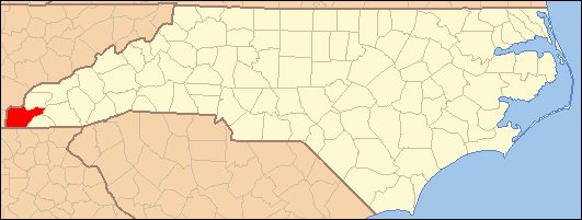
Adjacent counties

Monroe County, Tennessee Graham County Polk County, Tennessee 
Macon County  Cherokee County, North Carolina

Fannin County, Georgia Union County, Georgia Clay County National protected area
- Nantahala National Forest (part)
Transportation
Cherokee County is well known in North Carolina as the westernmost of the state's 100 counties. Several US and state highways serve the county, linking it with other regions of North Carolina, along with the neighboring states of Georgia and Tennessee.
US 64 - the longest highway in North Carolina, and a cross-country highway - passes through the county east-west. US 74, which links Chattanooga, Asheville, Charlotte and Wilmington, is a major 4-lane highway through the county. US 19 and US 129 also pass through Cherokee County, providing connections to Atlanta (to the south) and Knoxville (to the north).
Demographics
As of the census[2] of 2000, there were 24,298 people, 10,336 households, and 7,369 families residing in the county. The population density was 53 people per square mile (21/km²). There were 13,499 housing units at an average density of 30 per square mile (11/km²). The racial makeup of the county was 94.82% White, 1.59% Black or African American, 1.63% Native American, 0.28% Asian, 0.01% Pacific Islander, 0.45% from other races, and 1.21% from two or more races. 1.25% of the population were Hispanic or Latino of any race. 34.3% were of American, 10.8% Irish, 10.6% German and 10.3% English ancestry according to Census 2000. 97.7% spoke English and 1.2% Spanish as their first language.
There were 10,336 households out of which 25.60% had children under the age of 18 living with them, 58.80% were married couples living together, 9.30% had a female householder with no husband present, and 28.70% were non-families. 25.70% of all households were made up of individuals and 12.50% had someone living alone who was 65 years of age or older. The average household size was 2.32 and the average family size was 2.76.
In the county the population was spread out with 20.60% under the age of 18, 6.50% from 18 to 24, 24.40% from 25 to 44, 28.80% from 45 to 64, and 19.70% who were 65 years of age or older. The median age was 44 years. For every 100 females there were 94.20 males. For every 100 females age 18 and over, there were 90.70 males.
The median income for a household in the county was $27,992, and the median income for a family was $33,768. Males had a median income of $26,127 versus $18,908 for females. The per capita income for the county was $15,814. About 11.70% of families and 15.30% of the population were below the poverty line, including 19.20% of those under age 18 and 18.00% of those age 65 or over.
Cities and towns
 Map of Cherokee County, North Carolina With Municipal and Township Labels
See also
References
- ^ "Find a County". National Association of Counties. http://www.naco.org/Counties/Pages/FindACounty.aspx. Retrieved 2011-06-07.
- ^ "American FactFinder". United States Census Bureau. http://factfinder.census.gov. Retrieved 2008-01-31.
External links
- Official Cherokee County NC Government Website
- Cherokee County North Carolina Profile with photos
- Cherokee Live
Municipalities and communities of Cherokee County, North Carolina Towns 
Unincorporated
communitiesCategories:- North Carolina counties
- Cherokee County, North Carolina


Wikimedia Foundation. 2010.