- Ocean County, New Jersey
-
Ocean County, New Jersey 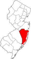
Location in the state of New Jersey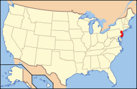
New Jersey's location in the U.S.Founded 1850 Seat Toms River Largest city Lakewood Township Area
- Total
- Land
- Water
916 sq mi (2,372 km²)
636 sq mi (1,647 km²)
280 sq mi (725 km²), 30.53%Population
- (2010)
- Density
576,567
906/sq mi (350/km²)Website www.co.ocean.nj.us Ocean County is a county located along the Jersey Shore in the U.S. state of New Jersey. Its county seat is Toms River[1], which, like the county itself, has been one of the fastest growing areas of the state since the 1990s. As of the 2010 United States Census, the population was 576,567. The 2000 Census population for the county was 510,916, making Ocean County the fastest growing in the state of New Jersey in terms of growth in the number of residents and second-highest in percentage growth.[2] Ocean County was established in 1850 from portions of Monmouth County except for Little Egg Harbor Township which seceded from Burlington County in 1891.
Ocean County is located 50 miles (80 km) east of Philadelphia, 70 miles (110 km) south of New York City, and 25 miles (40 km) north of Atlantic City, making it a prime destination for residents of these cities during the summer. As with the entire Jersey Shore, summer traffic routinely clogs local roadways throughout the season.
Ocean County is part of the New York metropolitan area, however, it is actually in the central part of New Jersey and is home to many tourist attractions frequently visited by Delaware Valley residents, especially the beachfront communities of Seaside Heights and Long Beach Island, as well as Six Flags Great Adventure, which is the home of the world's tallest and formerly fastest roller coaster, Kingda Ka. Ocean County is also a gateway to New Jersey's Pine Barrens, one of the largest protected pieces of land on the East Coast.
Contents
Geography
According to the U.S. Census Bureau, the county has a total area of 915.88 square miles (2,372.1 km2), the largest county in New Jersey, 636.28 square miles (1,648.0 km2) of it is land and 279.60 square miles (724.2 km2) of it (30.53%) is water.[3]
Much of the county is flat and coastal, and possesses many beaches. The highest point is one of three unnamed hills (one in Jackson Township, the other two in Plumsted Township) that reach at least 230 feet (70 m) in elevation. The lowest elevation in the county is sea level.
It is also home to many popular beaches such as Beach Haven, Ship Bottom, Surf City, Harvey Cedars and Barnegat Light.
Adjacent counties
- Monmouth County, New Jersey – north
- Atlantic County, New Jersey – south
- Burlington County, New Jersey – west

Monmouth County Burlington County 
Atlantic Ocean  Ocean County, New Jersey

Atlantic County National protected area
Demographics
Historical populations Census Pop. %± 1850 10,032 — 1860 11,176 11.4% 1870 13,628 21.9% 1880 14,455 6.1% 1890 15,974 10.5% 1900 19,747 23.6% 1910 21,318 8.0% 1920 22,155 3.9% 1930 33,069 49.3% 1940 37,706 14.0% 1950 56,622 50.2% 1960 108,241 91.2% 1970 208,470 92.6% 1980 346,038 66.0% 1990 433,203 25.2% 2000 510,916 17.9% 2010 576,567 12.8% historical census data source:[4][5] [2] As of the census[6] of 2000, there were 510,916 people, 200,402 households, and 137,876 families residing in the county. The population density was 803 people per square mile (310/km²). There were 248,711 housing units at an average density of 151/km² (391/sq mi). The racial makeup of the county was 93.05% White, 2.99% Black or African American, 0.14% Native American, 1.28% Asian, 0.02% Pacific Islander, 1.24% from other races, and 1.29% from two or more races. 5.02% of the population were Hispanic or Latino of any race. 24.9% were of Italian, 18.2% Irish, 12.5% German, 7.0% Polish and 5.4% English ancestry according to Census 2000.
There were 200,402 households out of which 28.10% had children under the age of 18 living with them, 56.40% were married couples living together, 9.20% had a female householder with no husband present, and 31.20% were non-families. 27.00% of all households were made up of individuals and 16.50% had someone living alone who was 65 years of age or older. The average household size was 2.51 and the average family size was 3.06.
In the county the population was spread out with 23.30% under the age of 18, 6.60% from 18 to 24, 26.00% from 25 to 44, 21.90% from 45 to 64, and 22.20% who were 65 years of age or older. The median age was 41 years. For every 100 females there were 90.40 males. For every 100 females age 18 and over, there were 86.40 males.
The median income for a household in the county as of 2009 was $60,787, and the median income for a family as of 2009 was $74,142. Males had a median income of $44,822 versus $30,717 for females. The 2009 per capita income for the county was $29,404. About 4.80% of families and 7.00% of the population were below the poverty line, including 10.00% of those under age 18 and 5.60% of those age 65 or over.
It is also home to Mantoloking (population 423), the wealthiest community in the state of New Jersey.
Government
Ocean County is governed by a Board of Chosen Freeholders consisting of five members, elected at large by the voters of Ocean County in partisan elections and serving staggered three-year terms. Ocean County's Freeholders have both administrative and policy making powers, and are paid some $50,000 in salary and additional benefits.[7] Ocean County also elects people to the constitutional office positions of county clerk and surrogate. The clerk is Carl W. Block (R), also former mayor of Stafford Township and the surrogate is Jeffrey Moran (R).
As of 2011[update], Ocean County's Freeholders are:[8]
- Freeholder Director Joseph H. Vicari (R) (Toms River Township, term ends December 31, 2011)
- Freeholder Deputy Director Gerry P. Little (R) (Surf City, 2012)
- John C. Bartlett, Jr. (R) (Pine Beach, 2012)
- John P. Kelly (R) (Eagleswood Township, 2013)
- James F. Lacey (R) (Brick Township, 2013)
Politics
Ocean County is one of the few Republican strongholds in New Jersey.
Doug Forrester carried Ocean County by 12 points in the 2005 New Jersey gubernatorial election, winning every municipality but Lakewood Township and South Toms River Boro. In the 2004 U.S. Presidential election, Republican George W. Bush carried the county by a 21.2% margin over Democrat John Kerry.[9] In 2008, the county voted for Republican John McCain by an 18.4% margin over Democrat Barack Obama, making it McCain's second-strongest county in New Jersey behind Sussex County, with Obama winning the Garden State by 15.5% margin over McCain,[10] who carried Ocean County's every municipality except South Toms River.[11] The last Democratic presidential candidate to win Ocean County was Bill Clinton in 1996. In the 2009 Gubernatorial Election, Republican Chris Christie received 64% of the vote, defeating incumbent Democrat Jon Corzine, who received 28%.
Education
Ocean County College is the two-year community college for Ocean County, one of a network of 19 county colleges statewide. The school is in Toms River and was founded in 1964.
Georgian Court University in Lakewood is a private Roman Catholic Sisters of Mercy college, which opened in 1908 on the former winter estate of millionaire George Jay Gould I, son of railroad tycoon Jay Gould. Lakewood is also home to Beth Medrash Govoha, a Haredi Yeshiva, which is one of the largest yeshivas in the world.[12]
The state's largest suburban school district, Toms River Regional Schools, is located in the county. Toms River is also home to Ocean County's only Roman Catholic High School, Monsignor Donovan High School, operated by the Roman Catholic Diocese of Trenton, which also has six elementary schools located in the county. [13]
In addition to multiple public high schools, the county has an extensive vocational high school program, known as the Ocean County Vocational Technical School district. In addition to its three campuses in Brick, Waretown, and Jackson, it contains two magnet schools:
- Marine Academy of Technology and Environmental Science (MATES)
- OCVTS Performing Arts Academy – Theater and Dance
Attractions
Ocean County has an extensive stretch along the Atlantic Ocean, including the Jersey Shore communities and oceanfront boardwalk resorts of Seaside Heights and Point Pleasant Beach.
Six Flags Great Adventure, America's largest Six Flags theme park, is home to the world's tallest and formerly fastest roller coaster, Kingda Ka. The park also contains Six Flags Hurricane Harbor, New Jersey's largest water park, and Six Flags Wild Safari, the largest drive-thru animal safari outside of Africa.
Forty miles of barrier beaches form the Barnegat and Little Egg Harbor Bays, offering ample watersports. It also is home of the Tuckerton Seaport, a 40-acre (160,000 m2) maritime history village in Tuckerton. In addition to being the northeast gateway to New Jersey's Pine Barrens, Ocean County is also home to several state parks:
Ocean County is also home to the Ocean County Mall in Toms River, and FirstEnergy Park, home of the Lakewood BlueClaws, the Class A-affiliate of the Philadelphia Phillies.
Transportation
Ocean County has various major roads that pass through. State routes that go through include Route 13, Route 35, Route 37, Route 70, Route 88, and Route 166. Other major routes that pass through are US Route 9, the Garden State Parkway, and Interstate 195 (I-195 is the only interstate to pass through Ocean County solely in Jackson).
Municipalities
The following is a list of the municipalities in Ocean County. Other, unincorporated areas in the county are listed below their parent municipality (or municipalities, as the case may be). Most of these areas are census-designated places that have been created by the United States Census Bureau for enumeration purposes within a Township. The numbers in parentheses stand for the numbers on the map.
 Index map of Ocean County municipalities (click to see index key)
- Barnegat Light (6)
- Barnegat Township (29)
- Barnegat CDP
- Ocean Acres (part)
- Bay Head (16)
- Beach Haven (2)
- Beachwood (12)
- Berkeley Township (26)
- Brick Township (23)
- Eagleswood Township (31)
- Harvey Cedars (5)
- Island Heights (10)
- Jackson Township (21)
- Lacey Township (27)
- Lakehurst (19)
- Lakewood Township (22)
- Lavallette (14)
- Little Egg Harbor Township (33)
- Long Beach Township (32)
- Manchester Township (25)
- Mantoloking (15)
- Ocean Gate (9)
- Ocean Township (28)
- Pine Beach (11)
- Plumsted Township (20)
- Point Pleasant (18)
- Point Pleasant Beach (17)
- Seaside Heights (8)
- Seaside Park (7)
- Ship Bottom (3)
- South Toms River (13)
- Stafford Township (30)
- Surf City (4)
- Toms River Township (County Seat) (24)
- Tuckerton (1)
See also
References
- ^ "Find a County". National Association of Counties. http://www.naco.org/Counties/Pages/FindACounty.aspx. Retrieved 2011-06-07.
- ^ a b The Counties and Most Populous Cities and Townships in 2010 in New Jersey: 2000 and 2010, United States Census Bureau. Accessed September 5, 2011. HTML version of original Excel spreadsheet.
- ^ GCT-PH1. Population, Housing Units, Area, and Density: 2000 for Ocean County, New Jersey -- County Subdivision and Place, United States Census Bureau. Accessed September 4, 2011.
- ^ "New Jersey Resident Population by County: 1880–1930". http://www.wnjpin.net/OneStopCareerCenter/LaborMarketInformation/lmi01/poptrd5.htm.
- ^ "Geostat Center: Historical Census Browser". University of Virginia Library. http://fisher.lib.virginia.edu/collections/stats/histcensus/. Retrieved 2007-03-02.
- ^ "American FactFinder". United States Census Bureau. http://factfinder.census.gov. Retrieved 2008-01-31.
- ^ Freeholder History, Ocean County, New Jersey. Accessed September 5, 2011.
- ^ Home page, Ocean County, New Jersey. Accessed September 5, 2011.
- ^ New Jersey Presidential Election Returns by County 2004, Eagleton Institute of Politics at Rutgers University. Accessed August 31, 2008.
- ^ 2008 Presidential General Election Results for New Jersey, USElectionAtlas.org. Accessed September 5, 2011.
- ^ 2008 Presidential General Election Results: Ocean County, New Jersey Department of State, December 23, 2008. Accessed September 4, 2011.
- ^ Fahim, Kareem (December 10, 2007). "As Orthodox Population Grows, So Do Tensions". The New York Times. http://www.nytimes.com/2007/12/10/nyregion/10lakewood.html?pagewanted=all. Retrieved 11 March 2010.
- ^ School Directory, Roman Catholic Diocese of Trenton. Accessed September 5, 2011.
External links
- Ocean County website
- Ocean County Planning Board's Databook
- Ocean County Historical Museum: History of Ocean County
- History of the County Courthouse from County Clerk's website
- Ocean County Library
- Photographic galleries featuring the flora,fauna,and landscapes of the New Jersey Pinelands: Featuring many photographs that reflect the natural beauty of Ocean County, New Jersey.
Municipalities and communities of Ocean County, New Jersey Boroughs 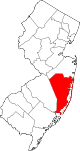
Townships Barnegat | Berkeley | Brick | Eagleswood | Jackson | Lacey | Lakewood | Little Egg Harbor | Long Beach | Manchester | Ocean | Plumsted | Stafford | Toms River
CDPs Barnegat | Beach Haven West | Cassville | Cedar Glen Lakes | Cedar Glen West | Crestwood Village | Dover Beaches North | Dover Beaches South | Forked River | Holiday City-Berkeley | Holiday City South | Holiday Heights | Lakewood | Leisure Knoll | Leisure Village | Leisure Village East | Leisure Village West-Pine Lake Park | Manahawkin | Mystic Island | New Egypt | North Beach Haven | Ocean Acres | Pine Ridge at Crestwood | Silver Ridge | Toms River | Vista Center | Waretown
Communities Bayville | Chadwick Beach Island | Harmony | High Bar Harbor | Jackson Mills | Lanoka Harbor | Loveladies | Parkertown | Silverton | Warren Grove | West Creek | West Tuckerton | Whitesville | Whiting
 State of New Jersey
Topics Regions - Atlantic Coastal Plain
- Central Jersey
- Delaware River Region
- Delaware Valley
- Gateway Region
- Gold Coast
- Highlands
- Jersey Shore
- Meadowlands
- New York metro area
- North Hudson
- North Jersey
- Pascack Valley
- Piedmont
- Pine Barrens
- Raritan Bayshore
- Ridge-and-Valley Appalachians
- Southern Shore Region
- Skylands Region
- South Jersey
- Tri‑State Region
- West Hudson
Counties Major cities Delaware Valley Counties Atlantic • Berks • Bucks • Burlington • Camden • Cape May • Cecil • Chester • Cumberland • Delaware • Gloucester • Mercer • Montgomery • New Castle • Ocean • Philadelphia • Salem
Major cities Cities and towns
50k-99kBensalem • Camden • Cherry Hill • Gloucester Township • Levittown • Reading • Trenton • Vineland • WilmingtonCities and towns
25k-50kCategories:- New Jersey counties
- Ocean County, New Jersey
- Pine Barrens of New Jersey
- 1850 establishments in the United States


Wikimedia Foundation. 2010.