- Cranham
-
For the Cranham in the Cotswolds, see Cranham, Gloucestershire.
Coordinates: 51°33′43″N 0°16′05″E / 51.561978°N 0.268006°E
Cranham 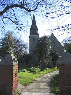
All Saints Church
 Cranham
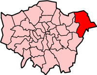
Cranham shown within Greater LondonOS grid reference TQ575875 - Charing Cross 17.5 mi (28.2 km) WSW London borough Havering Ceremonial county Greater London Region London Country England Sovereign state United Kingdom Post town UPMINSTER Postcode district RM14 Post town BRENTWOOD Postcode district CM13 Dialling code 01708 Police Metropolitan Fire London Ambulance London EU Parliament London UK Parliament Hornchurch and Upminster London Assembly Havering and Redbridge List of places: UK • England • London Cranham is a residential suburb in northeast London, England and part of the London Borough of Havering.[1] It is located 17.5 miles (28 km) east-northeast of Charing Cross and comprises an extensive built-up area to the north and a low density conservation area surrounded by open land to the south.[2] It was historically a rural village in the county of Essex and formed an ancient parish.[3] It is peripheral to London, forming the eastern edge of the urban sprawl. The economic history of Cranham is characterised by a shift from agriculture to housing development.[3] As part of the suburban growth of London in the 20th century, Cranham significantly increased in population,[4] becoming part of Hornchurch Urban District in 1934 and has formed part of Greater London since 1965.[5]
Contents
History
Toponomy
Cranham (parish) population 1881 416 1891 465 1901 397 1911 489 1921 519 1931 1,240 1941 war # 1951 2,836 # no census was held due to war source: UK census[4] The placename Cranham is first recorded in the Domesday Book of 1086 as Craohv and in 1201 as Craweno.[6] It means 'spur of land frequented by crows' and is formed from the Old English 'crāwe' and 'hōh'.[6] The parish contained two Anglo-Saxon manors of Ockendon (Wochenduna), while Cranham (Crawenho) was the smaller of the two.[3] During the Middle Ages, and until around the 15th century, the parish was also known as Bishop's Ockendon because the larger of the two manors had been owned by the Bishop of London; this still appeared on some victorian legal documents.[3]
Economic development
It is recorded in 1086 as being heavily wooded, supporting a poor, agrarian way of life.[3] Forest clearance was well advanced by the 15th century, with an increase in population and arable land; and there was a windmill in Cranham.[3] Cranham lay on brick earth and this gave rise to the Cranham Brick and Tile Company which was in operation from 1900 to 1920.[3] Drury has suggested that early trade was with the nearby settlements of Romford and Hornchurch and with London via the River Thames at Rainham.[2]
Local government
 1931: Cranham (5) within Romford Rural District, adjoining Upminster (4) and Great Warley (3)
Cranham formed an ancient parish of 1,879 acres (7.60 km2) in the Chafford hundred of Essex.[4] The vestry met in the church until 1829 and then at the parish workhouse.[3] In 1836 the parish was grouped for poor relief into the Romford Poor Law Union and for sanitary provision in 1875 into Romford rural sanitary district.[5] The sanitary district became Romford Rural District from 1894 and a parish council was formed to replace the vestry.
The parish formed part of the London Traffic Area from 1924 and the London Passenger Transport Area from 1933.[7] To reflect the significantly increased population in the area, Romford Rural District was abolished in 1934 and Cranham was amalgamated with neighbouring parishes into Hornchurch Urban District.[8] The parish council was abolished and Hornchurch Urban District Council became the local authority. There was a revision of boundaries with North Ockendon, which had been part of Orsett Rural District, absorbed into Cranham and a small area to the north, near Great Warley, transferred to Brentwood Urban District.[5]
In 1965 Hornchurch Urban District was abolished and its former area was transferred from Essex to Greater London, to be combined with that of the Municipal Borough of Romford in order to form the present-day London Borough of Havering.[9] In 1993 the Greater London boundary, to the east of Cranham and north of the railway line, was locally realigned to the M25 motorway, returning some mostly unpopulated areas of open land to Essex and leaving North Ockendon as the only part of Greater London outside the bounds of the motorway.[10]
Urban development
 Map of Cranham
In the 17th and 18th centuries the manorial homes, including Cranham Hall, became attractive properties for merchants from the City of London.[2] Initial attempts to expand the suburban estates from Upminster in the early 20th century ran into problems because of the lack of water supply.[3] In 1922 sewage works for Upminster and Cranham were opened in Great Warley.[11] In the 1930s land was used to develop some council housing and following the sale of the Benyon estate the pace of new building quickened. Cranham's location on the very edge of London's urban sprawl is explained by the halting effect on suburban house building of the introduction of the Metropolitan Green Belt and World War II.[2][3] Thereafter building took place within the area bounded by the Southend Arterial Road in the north and St Mary's Lane in the south; and there were 615 council houses built by 1971.[3]
Governance
Cranham forms part of the Hornchurch and Upminster UK Parliament constituency, and is partly within the Havering wards of Upminster and Cranham. Together these form the Upminster Area Committee.[12] The current MP is Angela Watkinson. Each ward elects three councillors to Havering London Borough Council. All six councillors elected in 2010 for the two wards were the Upminster and Cranham Residents' Association candidates[13][14] and the area is unusual in that the residents' association is strongly active.[15] From 1945 to 1974 Cranham formed part of the Hornchurch constituency and from 1974 to 2010 it formed part of the Upminster constituency. Cranham is within the Havering and Redbridge London Assembly constituency and the London European Parliament constituency.
Geography
Further information: Geography of LondonMost of Cranham is located on the London Clay belt, with loam to the north and a gravel valley to the south.[3] It rises to about 250 feet (76 m) in the north and to below 50 feet (15 m) in the south; with a ridge running east to west upon which All Saints church is located.[3] Cranham forms a continuously built-up area with Upminster to the west, with open fields separating it from Harold Wood in the north, Great Warley to the east and North Ockendon to the southeast. Franks Wood and Cranham Brickfields are designated a Site of Importance for Nature Conservation with a habitat of ancient woodland, pollards, ditches, scrub, tall herbs and neutral grassland.[16] The community forest centre for the extensive Thames Chase is located in the open land to the south east.[17] Cranham forms part of the Upminster post town in the RM14 postcode district.[18]
Despite Cranham being suburbian and not really urban, there is however a housing estate called Upminster Park Estate. It covers the northern area of Cranham, mostly the Front Lane area near Clyde Crescent.
Demography
Cranham compared (2001 Census) Statistic Upminster[19] Cranham[20] Havering[19] London[19] England[19] Ethnic group White 12,354 11,930 213,421 5,103,203 44,679,361 Asian 133 120 4,088 866,693 2,248,289 Black 59 64 3,139 782,849 1,132,508 Mixed 87 78 2,298 226,111 643,373 Chinese/Other 41 19 827 70,928 231,424 Population Total 12,674 12,242 224,248 7,172,091 49,138,831 Density(/hectare) 5.62 18.67 19.97 45.62 3.77 Households 4,946 5,111 91,722 3,015,997 20,451,427 Demographic data is produced by the Office for National Statistics for the wards of Cranham and Upminster. All of Cranham is contained within these wards, however they also cover the connected settlement of Upminster and the rural outlier of North Ockendon. In 2001 the population of Upminster ward was 12,674[19] and Cranham ward was 12,242,[20] giving a total population of 25,098. 80.95% in Upminster and 81.73% in Cranham report their religion as Christian, compared to 76.13% for Havering, 58.23% in London and 71.74% in England. 10.08% in Upminster and 10.46% in Cranham report having no religion, compared to 13.18% in Havering, 15.76% in London and 14.59% in England.[19][20] With a black and minority ethnic population of 3% in 2001, Cranham and Upminster wards have the lowest Simpson index for ethnic diversity in London.[21] The level of home ownership is atypically high compared to the rest of London and England, with over 90% of housing tenure under owner-occupation in both wards.[22][23]
Economy
There are three short parades of shops; the smallest in St.Mary's Lane, and two larger on Avon Road and in Front Lane, dominated by a Tesco Express store.[24] The nearest significant activity centre identified in the London Plan is the local district centre at Upminster.[1] Within Havering, Upminster is identified as the nearest of seven main town centres.[25] There are a number of commercial businesses centred around the A127 Southend Arterial Road including a wholesale butcher, mushroom cultivator, caravan sales, and a sports equipment supplier.[26] There are a limited number of hospitality venues, including pubs and a popular tandoori restaurant.[27]
Transport
Further information: Transport in London and Public transport in Havering Two floodlight towers in the London Underground depot are the tallest structures in Cranham
Front Lane is the main road through Cranham and runs north to south, connecting with the A127 road in the north. Approximately 0.5 miles (0.80 km) to the northeast it has a junction with the M25 motorway, which forms the outer ring road of London. Cranham is the location of the Upminster depot of the London Underground's District line.[28] The nearest London Underground station is at Upminster, approximately 0.75 miles (1.21 km) to the west. The London-Tilbury-Southend Line of the National Rail network passes through the area in two places, with the nearest station also at Upminster. There are Transport for London bus service to Upminster, Hornchurch, Romford, and Ockendon station on routes 248, 346 and 347.[29]
Culture
 Willow Parade and shops on Front Lane
All Saints parish church, re-built 1873, is a grade II listed building; James Oglethorpe, the first governor of Georgia, now part of the United States is buried in its chancel.[30][31] The area around the church forms a conservation area.[32] There is a second church called St Luke's further north on Front Lane[33] and two community associations that are both registered charities.[34][35] The Cranham Community Association operates a broad range of sporting, self improvement and hobby activities at Cranham Community Centre on Marlborough Gardens.[34] Cranham Social Hall, with a capacity of 100, is separately operated by the Front Lane Community Association, and provides a limited range of activities.[35][36] The main cultural and entertainment facilities of the borough are located in Hornchurch and Romford.[37]
See also
References
- ^ a b Mayor of London (May 2006). "The London Plan: East London Sub Regional Development Framework". Greater London Authority. http://www.london.gov.uk/archive/mayor/planning/srdf/docs/east-srdf.pdf. Retrieved 23 February 2010.
- ^ a b c d The Paul Drury Partnership (February 2007). "Cranham Conservation Area: Character Appraisal and Management Proposals". Havering London Borough Council. http://www.havering.gov.uk/CHttpHandler.ashx?id=7554. Retrieved 23 February 2010.
- ^ a b c d e f g h i j k l m Powell, W.R. (Edr.) (1978). Parishes: Cranham, A History of the County of Essex: Volume 7. Victoria County History. British History Online. http://www.british-history.ac.uk/report.aspx?compid=42823. Retrieved 23 February 2010.
- ^ a b c Vision of Britain - Cranham population (area and density). Retrieved on 23 February 2010.
- ^ a b c Vision of Britain - Cranham parish (historic map). Retrieved on 23 February 2010.
- ^ a b Mills, D. (2000). Oxford Dictionary of London Place Names. Oxford.
- ^ Robson, William (1939). The Government and Mis-government of London. London: Allen & Unwin.
- ^ Powell, W.R. (Edr.) (1978). Hornchurch: Economic history and local government, A History of the County of Essex: Volume 7. Victoria County History. British History Online. http://www.british-history.ac.uk/report.aspx?compid=42811. Retrieved 23 February 2010.
- ^ Vision of Britain - Havering London Borough. Retrieved on 23 February 2010.
- ^ "Essex and Greater London (County and London Borough Boundaries) (No.2) Order 1993". Office of Public Sector Information. 1993. http://www.opsi.gov.uk/si/si1993/Uksi_19931218_en_1.htm. Retrieved 23 February 2010.
- ^ Powell, W.R. (Edr.) (1978). Upminster: Local government and parliamentary representation, A History of the County of Essex: Volume 7. Victoria County History. British History Online. http://www.british-history.ac.uk/report.aspx?compid=42830. Retrieved 23 February 2010.
- ^ Upminster Area Committee (June 2009). "Upminster Area Committee (Cranham & Upminster Wards) Agenda". Havering London Borough Council. http://www.havering.gov.uk/CHttpHandler.ashx?id=18289&p=0. Retrieved 23 February 2010.
- ^ "Cranham Ward - Local election results 2006". Havering London Borough Council. 16 November 2007. http://www.havering.gov.uk/index.aspx?articleid=6032. Retrieved 23 February 2010.
- ^ "Upminster Ward - Local election results 2006". Havering London Borough Council. 16 November 2007. http://www.havering.gov.uk/index.aspx?articleid=6050. Retrieved 23 February 2010.
- ^ Baston, Lewis (8 February 2008). "Havering and Redbridge". guardian.co.uk. http://www.guardian.co.uk/politics/2008/feb/08/havering.redbridge. Retrieved 23 February 2010.
- ^ "Franks Wood and Cranham Brickfields". Havering London Borough Council. 10 September 2007. http://www.havering.gov.uk/index.aspx?articleid=4369. Retrieved 23 February 2010.
- ^ "Location Map for the Thames Chase Forest Centre, Broadfields, Pike Lane, Cranham, Upminster". Thames Chase. http://www.thameschase.org.uk/directions.pdf. Retrieved 23 February 2010.
- ^ Royal Mail (2004). Address Management Guide. Royal Mail Group. p. 168.
- ^ a b c d e f Neighbourhood Statistics (2001). "2001 Census: Census Area Statistics, Area: Upminster (Ward)". Office for National Statistics. http://www.neighbourhood.statistics.gov.uk/dissemination/LeadAreaSearch.do?a=7&c=romford+town&d=14&r=1&i=1001&m=0&s=1250418652857&enc=1&areaSearchText=upminster&areaSearchType=14&extendedList=false&searchAreas=. Retrieved 23 February 2010.
- ^ a b c Neighbourhood Statistics (2001). "2001 Census: Census Area Statistics, Area: Cranham (Ward)". Office for National Statistics. http://www.neighbourhood.statistics.gov.uk/dissemination/LeadDatasetList.do?a=7&b=6096871&c=cranham&d=14&g=336496&i=1001x1003&m=0&r=1&s=1250418744778&enc=1&domainId=16. Retrieved 23 February 2010.
- ^ Piggott, Gareth (January 2006). "Simpson's diversity indices by ward 1991 and 2001". Data Management and Analysis Group. Greater London Authority. http://www.london.gov.uk/archive/gla/publications/factsandfigures/dmag-briefing-2006-2.pdf. Retrieved 23 February 2010.
- ^ "Area: Upminster (Ward): Tenure (KS18)". Neighbourhood Statistics. Office for National Statistics. 9 November 2004. http://www.neighbourhood.statistics.gov.uk/dissemination/LeadTableView.do?a=7&b=6113906&c=upminster&d=14&e=7&g=337152&i=1001x1003x1004&m=0&r=1&s=1265616037044&enc=1&dsFamilyId=53. Retrieved 23 February 2010.
- ^ "Area: Cranham (Ward): Tenure (KS18)". Neighbourhood Statistics. Office for National Statistics. 9 November 2004. http://www.neighbourhood.statistics.gov.uk/dissemination/LeadTableView.do?a=7&b=6113890&c=cranham&d=14&e=7&g=336496&i=1001x1003x1004&m=0&r=1&s=1265616243680&enc=1&dsFamilyId=53. Retrieved 23 February 2010.
- ^ "Cranham Tesco Express". Tesco. http://www.tesco.com/storelocator/access/details.asp?bID=3329&l=U. Retrieved 23 February 2010.
- ^ "Town centre management". Havering London Borough Council. 14 October 2008. http://www.havering.gov.uk/index.aspx?articleid=379. Retrieved 9 February 2010.
- ^ "Public Register - Food Registrations". Havering London Borough Council. 10 January 2007. http://www.havering.gov.uk/media/pdf/c/t/Food_RegistrationsJan'07.pdf. Retrieved 23 February 2010.
- ^ "Night fever sweeps Havering as award winners announced". Havering London Borough Council. 17 June 2009. http://www.havering.gov.uk/index.aspx?articleid=16052. Retrieved 23 February 2010.
- ^ "Upminster depot celebrates 50th anniversary". Transport for London. 24 August 2009. http://www.tfl.gov.uk/static/corporate/media/newscentre/archive/12433.html. Retrieved 23 February 2010.
- ^ Transport for London (1 March 2008). "Buses from Upminster". Greater London Authority. http://www.tfl.gov.uk/tfl/gettingaround/maps/buses/pdf/upminster-2272.pdf. Retrieved 23 February 2010.
- ^ "All Saints Church, The Chase, Cranham". Havering London Borough Council. http://www.havering.gov.uk/index.aspx?articleid=8849. Retrieved 23 February 2010.
- ^ "All Saints' Cranham". 7 May 2010. http://www.allsaintscranham.co.uk/generaloglethorpe.html. Retrieved 22 May 2010.
- ^ "Cranham Conservation Area". Havering London Borough Council. 6 February 2006. http://www.havering.gov.uk/CHttpHandler.ashx?id=2359&p=0. Retrieved 23 February 2010.
- ^ "St Luke's Cranham with Moor Lane Church". 2009. http://www.stlukescranham.org. Retrieved 22 May 2010.
- ^ a b "Cranham Community Association". Havering London Borough Council. 19 January 2010. http://www.havering.gov.uk/index.aspx?articleid=15494. Retrieved 23 February 2010.
- ^ a b "Welcome to Cranham Social Hall Website". http://www.cranhamsocialhall.co.uk/. Retrieved 23 February 2010.
- ^ "Cranham Social Hall (Front Lane Community Association)". Havering London Borough Council. 19 January 2010. http://www.havering.gov.uk/index.aspx?articleid=14998. Retrieved 23 February 2010.
- ^ Urban Practitioners & Allies and Morrison (July 2005). "Romford Urban Strategy". Havering London Borough Council. http://www.havering.gov.uk/CHttpHandler.ashx?id=4743&p=0. Retrieved 23 February 2010.
External links
London Borough of Havering Districts Ardleigh Green · Chase Cross · Coldharbour · Collier Row · Corbets Tey · Cranham · Elm Park · Emerson Park · Frog Island · Gallows Corner · Gidea Park · Hacton · Harold Hill · Harold Park · Harold Wood · Havering-atte-Bower · Heath Park · Hornchurch · Noak Hill · North Ockendon · Rainham · Rise Park · Romford · Rush Green · South Hornchurch · Upminster · Upminster Bridge · Wennington
Attractions CEME · The Diver · Havering Museum · Langtons · Queen's Theatre · Rainham Hall · Tithe Barn Museum · Upminster WindmillMajor retail Parks and open spaces Bedfords Park · Dagnam Park · Havering Country Park · Hornchurch Country Park · Pyrgo Park · Tylers Common · Wildspace Conservation Park · Upminster ParkConstituencies Tube and rail stations Other topics Categories:- Districts of London
- Districts of Havering
- Districts of London listed in the Domesday Book


Wikimedia Foundation. 2010.