- Edgware
-
For other uses, see Edgware (disambiguation).
Coordinates: 51°37′07″N 0°16′22″W / 51.6185°N 0.2729°W
Edgware 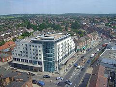
Station Road, Edgware; facing North.
 Edgware
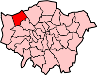
Edgware shown within Greater LondonOS grid reference TQ195925 - Charing Cross 10 mi (16 km) SE London borough Barnet Harrow Ceremonial county Greater London Region London Country England Sovereign state United Kingdom Post town EDGWARE Postcode district HA8 Post town EDGWARE Postcode district HA8 Dialling code 020 Police Metropolitan Fire London Ambulance London EU Parliament London UK Parliament Hendon London Assembly Barnet and Camden Brent and Harrow List of places: UK • England • London Edgware is an area in London, situated 10 miles (16.1 km) north-northwest of Charing Cross. It forms part of both the London Borough of Barnet and the London Borough of Harrow. The area is identified in the London Plan as one of 35 major centres in Greater London.[1]
It is principally a shopping and residential area and is one of the northern termini of the Northern Line. It has a bus garage, a shopping centre called The Broadwalk, a library, a large hospital—Edgware Community Hospital, and two streams—Edgware Brook and Deans Brook, both tributaries of the Silk Stream, which in turn merges with the River Brent at the Welsh Harp (Brent Reservoir).
Contents
History
Main article: History of EdgwareEdgware (parish) population 1881 816 1891 864 1901 868 1911 1,233 1921 1,516 Absorbed by Hendon parish ► source: UK census Edgware was an ancient hamlet in the county of Middlesex. Edgware is a Saxon name meaning Ecgi's weir. Ecgi was a Saxon and the weir relates to a pond where Ecgi's people would catch fish. The Edgware parish formed part of Hendon Rural District from 1894.[2] It was abolished in 1931 and formed part of the Municipal Borough of Hendon until 1965.[3] The Romans made pottery at Brockley Hill, and is thought by some to be the site of Sulloniacis. Canons Park, to the north-west, was developed as an estate by James Brydges, 1st Duke of Chandos and was the site of his great palace Canons.
Edgware was associated with the highwayman Dick Turpin—it was the infamous scene of his worst incident, which happened on 4 February 1735, when five gang members, including Turpin, broke into a farmhouse owned by Joseph Lawrence, called Earlsbury Farm. Lawrence was at least 70 (so considered fairly old) and yet Turpin et al. beat him with their pistols and tortured him by setting him on fire whilst naked. While this was going on, the leader of the gang took a servant girl upstairs and raped her.
Geography
Edgware is a post town within the HA postcode area.[4] It extends into the London Borough of Harrow to include Canons Park and Little Stanmore and into the London Borough of Brent to include part of Queensbury.
Neighbouring areas 
Bushey Elstree Borehamwood Stanmore 
Mill Hill  Edgware

Queensbury Burnt Oak Colindale Demography

Edgware is one of the major Jewish enclaves within London.[5] In the 2001 Census, 36% of Edgware residents give their religion as Jewish, 28% Christian, 9% Hindu and 5% Muslim.[6]
The Jewish community in Edgware has constructed its own Eruv.[7]
Nearby tube stations
Buses
London Buses serving Edgware are: routes 32, 79, 107, 113, 142, 186, 204, 221, 240, 251, 288, 292, 303, 305 and 340, including night-routes N5 and N16. Most of them terminate at Edgware's local bus station, with some calling there. There are also two Uno buses serving the area; routes 614 and 644.
Notable people
Main article: List of people from Barnet- Eleanor Bron — actor
- Max Bygraves — singer and actor
- Antony Costa — singer from boy band Blue
- Charlotte McDonagh — actor/television presenter/model and singer
- Shirley Eaton — actor
- Vanessa Feltz — TV/radio presenter
- Dayan Michoel Fisher — Emeritus Principal Rabbi of the Federation of Synagogues
- George Frideric Handel — composer
- Pat Sharp — disc jockey and television presenter
- Ben Strevens — footballer currently playing for Wycombe Wanderers
- Frank Williams — actor, most notable role: the vicar in Dad's Army
- John Bercow — The current Speaker of the House of Commons and MP for Buckingham
- Nicolas Anelka — football player, when playing for Arsenal F.C.
- Mitchell Symons — journalist and author
- Barry Norman — television presenter and author
- Christopher Wreh — former Arsenal football player
- Victor Feldman — jazz pianist
- Patrick Vieira — former Arsenal football player
- Archie Panjabi — Emmy Award winning actress, currently portraying Kalinda Sharma on The Good Wife (TV series)
Education
Main article: List of schools in the London Borough of Barnet- The London Academy
- Edgware Jewish Preparatory School
- Holland House School
- Broadfields Primary School
- Deansbrook Primary School
- North London Collegiate School
- Rosh Pinah Primary School
- Edgware Junior School
References
- ^ Mayor of London (February 2008). "London Plan (Consolidated with Alterations since 2004)". Greater London Authority. http://www.london.gov.uk/thelondonplan/docs/londonplan08.pdf.
- ^ Vision of Britain - Hendon Rural District
- ^ Vision of Britain - Edgware parish
- ^ Royal Mail, Address Management Guide (2004)
- ^ Milmo, Cahal (Saturday, 3 August 2002). "Britain's first 'eruv' enclave for Jews divides local opinion". London: The Independent. http://www.independent.co.uk/news/uk/home-news/britains-first-eruv-enclave-for-jews-divides-local-opinion-638639.html. Retrieved 2009-02-26.
- ^ "see Barnet Census Profile" (PDF). http://www.barnet.gov.uk/census-profile-edgware.pdf. Retrieved 2011-06-30.
- ^ "The Edgware Eruv". The Edgware Eruv. 2006-10-17. http://www.edgwareeruv.org. Retrieved 2011-06-30.
External links
London Borough of Harrow Districts Belmont · Canons Park · Greenhill · Harrow · Harrow on the Hill · Harrow Weald · Hatch End · Headstone · Kenton · Little Stanmore · North Harrow · Pinner · Pinner Green · Queensbury · Rayners Lane · Roxeth · South Harrow · Stanmore · Sudbury · Wealdstone · West Harrow
Attractions Parks and open spaces Chandos Recreation Ground · Kenton Recreation Ground · Pinner Park · West Harrow Recreation GroundConstituencies Tube and rail stations Other topics People · Public art · SchoolsLondon Borough of Brent Districts Alperton · Brent Park · Brondesbury · Brondesbury Park · Church End · Cricklewood · Dollis Hill · Harlesden · Kensal Green · Kenton · Kilburn · Kingsbury · Neasden · North Wembley · Park Royal · Preston · Queensbury · Queen's Park · South Kenton · Stonebridge · Sudbury · Tokyngton · Wembley · Wembley Park · Willesden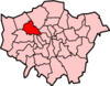
Attractions Brent Museum · Dollis Hill House · Neasden Temple · Oriental City · The Stables Gallery & Art Centre · Tricycle Theatre · Wembley Stadium ·Parks and open spaces Barham Park · Fryent Country Park · Gladstone Park · King Edward VII Park · Northwick Park · Roundwood parkConstituencies Tube and rail stations Alperton · Brondesbury railway station · Brondesbury Park railway station · Dollis Hill · Harlesden station · Kensal Green · Kensal Rise railway station · Kenton station · Kilburn · Kilburn Park · Kingsbury · Neasden · North Wembley station · Northwick Park · Preston Road · Queensbury · Queen's Park · South Kenton station · Stonebridge Park · Sudbury & Harrow Road railway station · Sudbury Town · Wembley Central station · Wembley Park · Wembley Stadium railway station · Willesden Green · Willesden JunctionOther topics Categories:- Districts of London
- Districts of Barnet
- Orthodox Jewish communities in London
- Major centres of London


Wikimedia Foundation. 2010.