- Marylebone
-
Not to be confused with St Mary-le-Bow.
Coordinates: 51°31′04″N 0°08′49″W / 51.5177°N 0.1470°W
Marylebone 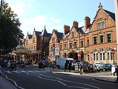
Marylebone station
 Marylebone
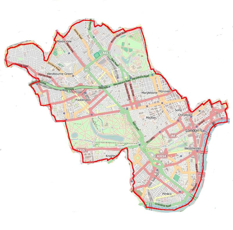
Marylebone shown within Greater LondonOS grid reference TQ285815 London borough Westminster Ceremonial county Greater London Region London Country England Sovereign state United Kingdom Post town LONDON Postcode district W1 Dialling code 020 Police Metropolitan Fire London Ambulance London EU Parliament London UK Parliament Cities of London and Westminster London Assembly West Central List of places: UK • England • London Marylebone (pronounced /ˈmɑrlɨbən/ (
 listen) mar-li-bən) is an affluent inner-city area of central London, located within the City of Westminster. It is sometimes written as St. Marylebone or Mary-le-bone.
Marylebone is in an area of London that can be roughly defined as bounded by Oxford Street to the south, Marylebone Road to the north, Edgware Road to the west and Great Portland Street to the east.[1] A broader definition designates the historic area as Marylebone Village and encompasses neighbouring Regent's Park, Baker Street and the area immediately north of Marylebone Road, containing Marylebone Station, the original site of the Marylebone Cricket Club at Dorset Square, and the neighbourhood known as Lisson Grove to the border with St John's Wood. The west side of the Fitzrovia area up to Cleveland Street was also previously considered to be part of Marylebone.[2]
Today the area is mostly residential, with many medical and dental offices, traditionally concentrated in Harley Street. Since the opening of the Jubilee Line at Baker Street station (with its direct links to Canary Wharf), Marylebone – particularly Marylebone Village – has become an even more sought-after area of Central London.
Contents
History
See also: History of LondonMarylebone gets its name from a church dedicated to St Mary, represented now by St Marylebone Parish Church (1817); the original church was built on the bank of a small stream or "bourne", called the Tybourne or Tyburn,[3] that rose further north in what is now Swiss Cottage, eventually running along what is now Marylebone Lane which preserves its curve within the grid pattern. The church and the surrounding area later became known as St Mary at the Bourne which, over time, became shortened to its present form, Marylebone.[4] It is a common misunderstanding that the name is a corruption of Marie la Bonne (French for "Marie/Mary the good").[citation needed]
The manor of Tyburn is mentioned in the Domesday Book (1086) as a possession of Barking Abbey valued at 52 shillings, with a population no greater than fifty people. Early in the thirteenth century it was held by Robert de Vere, 3rd Earl of Oxford. At the end of the fifteenth century Thomas Hobson bought up the greater part of the manor; in 1544 his son Thomas exchanged it with Henry VIII,[5] who enclosed the northern part of the manor as a deer park, the distant origin of Regent's Park. Tyburn manor remained with the Crown until the southern part was sold in 1611 by James I, who retained the deer park, to Edward Forest,[6] who had held it as a fixed rental under Elizabeth I. Forest's manor of Marylebone then passed by marriage into the family of Austen. The deer park, Marylebone Park Fields, was let out in small holdings for hay and dairy produce.[7]
In 1710, John Holles, Duke of Newcastle, purchased the manor for £17,500,[8] and his daughter and heir, Lady Henrietta Cavendish Holles, by her marriage to Edward Harley, Earl of Oxford, passed it into the family of the Earl of Oxford, one of whose titles was Lord Harley of Wigmore. She and the earl, realising the need for fashionable housing north of the Oxford Road, commissioned the surveyor and builder John Prince to draw a master plan that set Cavendish Square in a rational grid system of streets.
The Harley heiress Lady Margaret Cavendish Harley married William, 2nd Duke of Portland, and took the property, including Marylebone High Street, into the Bentinck family. Such place names in the neighbourhood as Cavendish Square and Portland Place reflect the Dukes of Portland landholdings and Georgian-era developments there. In 1879 the fifth Duke died without issue and the estate passed through the female line to his sister, Lucy Joan Bentinck, widow of the 6th Baron Howard de Walden.
A large part of the area directly to the west was constructed by the Portman family and is known as the Portman Estate. Both estates have aristocratic antecedents and are still run by members of the aforementioned families. The Howard de Walden Estate owns, leases and manages the majority of the 92 acres (370,000 m2) of real estate in Marylebone which comprises the area from Marylebone High Street in the west to Robert Adam’s Portland Place in the east and from Wigmore Street in the south to Marylebone Road in the north.[9]
In the 18th century the area was known for the raffish entertainments of Marylebone Gardens, scene of bear-baiting and prizefights by members of both sexes, and for the duelling grounds in Marylebone Fields.[10] The Crown repurchased the northern part of the estate in 1813.
The Metropolitan Borough of St Marylebone was a metropolitan borough of the County of London between 1899 and 1965, after which, with the Metropolitan Borough of Paddington and the Metropolitan Borough of Westminster it was merged into the City of Westminster.
Streets
Mansfield Street is a short continuation of Chandos Street built by the Adam brothers in 1770, on a plot of ground which had been underwater. Most of its houses are fine buildings with exquisite interiors, when put on the market now will have a price tag in excess of £10 million. It has attracted people who understand attractive buildings – at Number 13 lived religious architect John Loughborough Pearson who died in 1897, and Drogo & Delhi designer Sir Edwin Lutyens, who died in 1944. Immediately across the road at 61 New Cavendish Street lived Natural History Museum creator Alfred Waterhouse.
Queen Anne Street is an elegant cross-street which unites the northern end of Chandos Street with Welbeck Street. The painter JMW Turner moved to 47 Queen Anne Street in 1812 from 64 Harley Street, now divided into numbers 22 and 23, and owned the house until his death in 1851. It was known as "Turner's Den", becoming damp, dilapidated, dusty, dirty, with dozens of Turner's works of art now in the National Gallery scattered throughout the house, walls covered in tack holes and a drawing room peopled by cats with no tails.
During the same period a few hundred yards to the east, Chandos House in Chandos Street was used as the Austro-Hungarian Embassy and residence of the fabulously extravagant Ambassador Prince Paul Anton III Esterhazy, seeing entertainment on a most lavish scale. The building is one of the finest surviving Adam houses in London, and now lets rooms.
Wimpole Street runs from Henrietta Place north to Devonshire Street, becoming Upper Wimpole enroute – the latter where Arthur Conan Doyle opened his ophthalmic practice at number 2 in 1891. A six-floor, Grade II 18th-century house at 57 Wimpole Street is where Paul McCartney resided from 1964–66, staying on the top floor of girlfriend Jane Asher’s family home in a room overlooking Browning Mews in the back, and with John Lennon writing I Want to Hold Your Hand on a piano in the basement. At her father's house at number 50 lived for some time between 1840 and 1845, Miss Elizabeth Barrett, then known as the author of a volume of poems, and who afterwards escaped and was better known as Mrs. E. Browning. Today, at the bottom end of Wimpole at Wigmore can be found a sandwich shop named "Barrett's".
Bentinck Street leaves Welbeck Street and touches the middle of winding Marylebone Lane. Charles Dickens lived at number 18 with his indebted father (aka Wilkins Micawber) while working as a court reporter in the 1830s, and Edward Gibbon wrote much of The Decline and Fall of the Roman Empire while living at number 7 from the early 1770s. James Smithson wrote the will that led to the foundation of the Smithsonian Institution while living at number 9 in 1826, while number 10 was briefly graced by Chopin in 1848, who found his apartment too expensive and moved to Mayfair. More recently, Cambridge Spies Anthony Blunt and Guy Burgess shared a flat at an unrecorded Bentinck Street address during the Second World War, as did Swinging Sixties two-some John Dunbar and TV repairman “Magic Alex”, where the former introduced the latter to John Lennon in 1967.
Manchester Square, west of Bentinck street, has a central private garden with handsome plane trees, laid out in 1776. The mansion on the north side of the Square, now the home of the Wallace Collection that features world-class French eighteenth-century painting, porcelains and furniture, once housed the Spanish ambassador, whose chapel was in Spanish Place. From the north-west corner is Manchester Street, final home of Georgian-era prophet Joanna Southcott, who died there in 1814, having attracted a jeering mob with report of a miraculous birth and prediction the Day of Judgement would arrive in the year 2004.
Marylebone has some “Beatles” heritage, with a Ringo Starr flat at 34 Montagu Square, and the original Apple Corps HQ at 95 Wigmore Street.
Welbeck Street at the intersection of a right turn onto Bentinck Street was the location of a near-fatal traffic accident for Sherlock Holmes in The Final Problem, soon followed by a narrow escape from a falling brick in Vere Street – Professor Moriarty's work, most likely.
Bulstrode Street, small and charming, is named for a Portman family estate in Buckinghamshire, itself named after a local family there made-good in Tudor days. Tucked away, with a few terraced houses, Bulstrode has been the home of minor health care professionals for hundreds of years. RADA student and aspiring actress Vivien Leigh, aged twenty in 1933, gave birth at the Rahere Nursing Home, then at number 8, to her first child. Also, a small tubercular patch in her lungs was discovered.
The north end of Welbeck joins New Cavendish Street, the name changed from Upper Marylebone Street in the late nineteenth century. At a house across New Cavendish from its join with Welbeck, that stood at number 13 on the corner of Marylebone Street, was born in 1882 Leopold Stokowski, son of a Polish cabinet maker. Young Stokowski sang in the choir of St Marylebone Church.
Walking north on Marylebone High Street towards the Marylebone Road reaches an area with a colourful history, which includes the former Marylebone Gardens, whose entertainments including bare-knuckle fighting, a cemetery, a workhouse, and the areas frequented by Charles Wesley, all shut down by the close of the 18th century, where today we find mansion blocks and upper-end retail. At their rented flat at number 100 in the High Street, Cliff Richard, Hank Marvin and Bruce Welch gazed at one of the UK's first Fender Stratocasters in 1959.
At Number 1 Dorset Street resided mid-Victorian scientist Charles Babbage, inventor of the Analytical Engine. Babbage complained that two adjacent hackney-coach stands in Paddington Street ruined the neighbourhood, leading to the establishment of coffee and beer shops, and furthermore, the character of the new population could be inferred from the taste they exhibited for the noisiest and most discordant music. As if in response, a venue for chamber music, the Wigmore Hall, opened at 36 Wigmore Street in 1901. It hosts over 400 events each year.
Governance
Marylebone was formerly a part of the Metropolitan Borough of St Marylebone, and the St Marylebone UK Parliament constituency (1918–1983).
Geography
Neighbouring areas of London 
Lisson Grove St John's Wood Regent's Park Paddington 
Fitzrovia  Marylebone

Hyde Park Mayfair Soho Areas of Marylebone include:
- All Souls Church, Langham Place (designed by John Nash)
- Asia House, New Cavendish Street
- Baker Street (including the fictitious 221B Baker Street)
- Bryanston Square
- Broadcasting House (BBC headquarters)
- The Colomb Art Gallery
- Duke Street, Marylebone
- Holy Trinity Church Marylebone (designed by Sir John Soane)
- Langham Hotel, London (built in the 1860s)
- Marylebone High Street
- Madame Tussaud's
- Manchester Square (Georgian square)
- Montagu Square (Regency square)
- University of Westminster
- Royal Academy of Music
- Royal Institute of British Architects
- Harley Street
- Regent's Park (which houses the London Zoo)
- Selfridges Department Store
- Hyde Park
- Marybone Chapel (designed in 1722 by James Gibbs)
- Wallace Collection
- Wigmore Hall
- Marble Arch
- Wigmore Street
- West London Mission at 19 Thayer Street
- Wyndham Place
- Hinde Street Methodist Chapel
Landmarks
Former landmarks
- Egton House, studio of BBC Radio 1, demolished
- Queen's Hall, classical music concert venue destroyed by fire in World War II
- Marylebone Gardens a former pleasure ground and venue for concerts, closed in 1778
- St. George's Hall (London), a theatre built in 1867, demolished 1966.
- Yorkshire Stingo, a public house on Marylebone Road.
- St Marylebone Grammar School, on the corner of Lisson Grove and Marylebone Road, now an office building.
Transport
Tube stations
- Baker Street
- Bond Street
- Edgware Road (Bakerloo Line)
- Edgware Road (Circle, District and Hammersmith & City Lines)
- Marble Arch
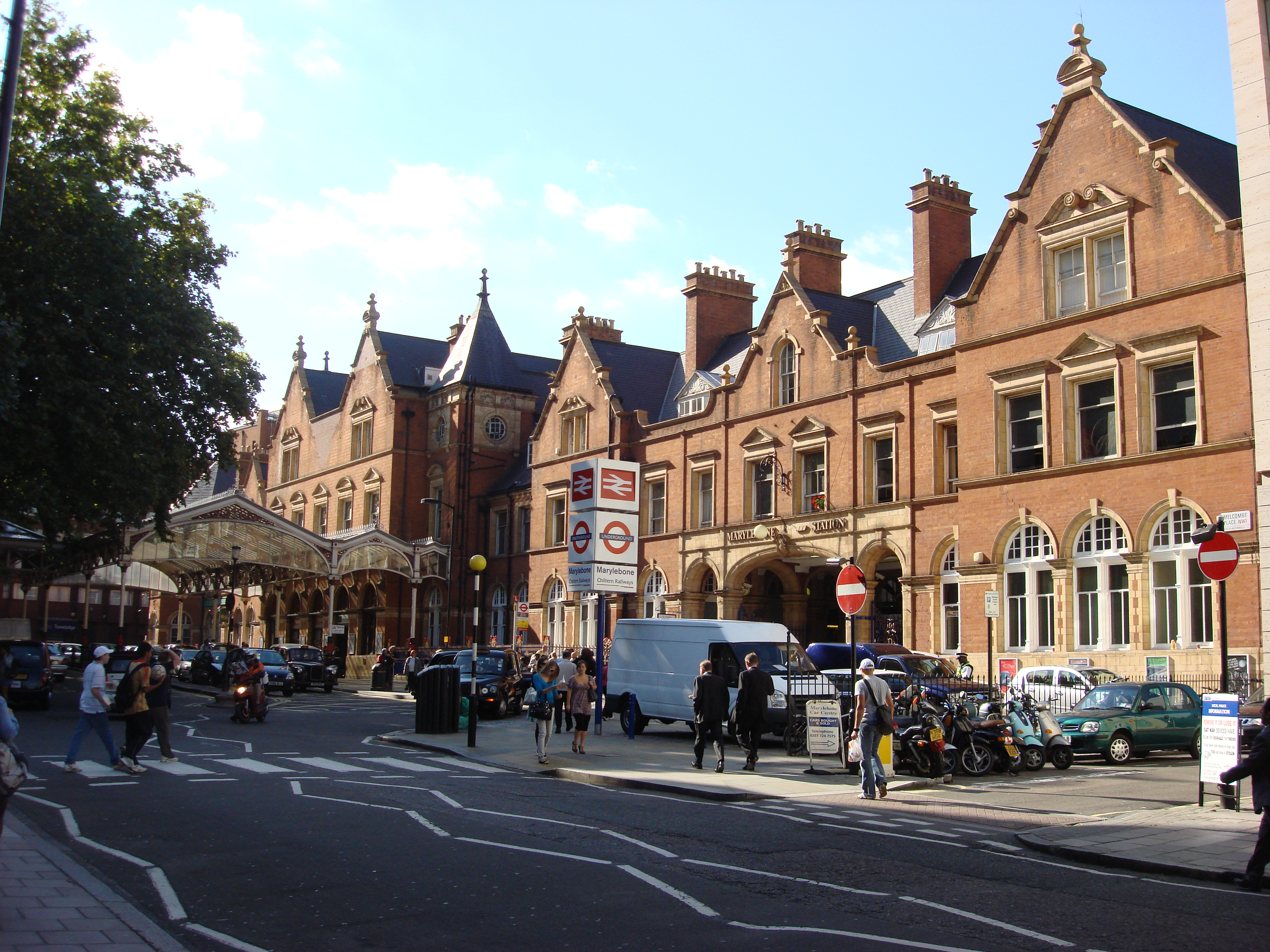
- Marylebone
- Oxford Circus
- Regent's Park
Railway stations
Bus
The area Seving Routes 2, 13, 18, 27, 30, 74, 82, 113, 139, 189, 205, 274, 453 And Night Routes N13, N18, N74
Education
For education in Marylebone, see List of schools in the City of Westminster.- St Marylebone School (comprehensive specialist school in Performing Arts, Maths & Computing for girls founded in 1791)
- Sylvia Young Theatre School (fee paying performing arts school)
- St Vincent's RC Primary School (Catholic Voluntary Aided Mixed School)
- Francis Holland School (independent day school for girls)
- Portland Place School (independent secondary school)
- The Royal Academy of Music on Marylebone Road
- The University of Westminster on Marylebone Road and upper Regent Street
- Regent's College, whose campus is within the grounds of Regent's Park, which houses:European Business School London; British American College London; Regent's Business School; School of Psychotherapy and Counselling; Webster Graduate School; Internexus, a provider of English language courses.
Notable residents
See also: List of people from LondonSherlock Holmes of 221B Baker Street is perhaps the best-known fictional resident. Actual residents, past and present, include:
- Adam Ant
- Alfred Jules Ayer
- Benedict Arnold
- Jane Asher
- Steve Jones (presenter)
- Charles Babbage
- Francis Beaufort
- Isabella Blow
- Derren Brown
- Elizabeth Barrett Browning
- Richard Tappin Claridge
- William Coldstream
- Joe Cole
- Wilkie Collins
- Nipper Pat Daly
- Charles Dickens
- Jacqueline du Pré
- Tamsin Egerton
- Sir Clement Freud
- Noel Gallagher
- Edward Gibbon
- Hughie Green
- Richard Hammond
- Keeley Hawes
- Jimi Hendrix
- Alexander Hewat
- Edward Lear
- John Lennon
- Dom Joly
- Madonna
- Paul McCartney
- Sienna Miller
- Jonathan Myles-Lea
- Yoko Ono
- Pitt the Elder
- Stuart Price
- Patrick Procktor
- Corin Redgrave
- Wendy Richard
- Talulah Riley
- Guy Ritchie
- Dodie Smith
- Stephen Spender
- Ringo Starr
- Cat Stevens
- Stephen Ward
- H. G. Wells
- Charles Wesley
- Barbara Windsor[11]
- Dale Winton
- Norman Wisdom
References
- ^ Marylebone Association
- ^ Horwood Map(1792-1799)
- ^ ""Maryburne rill", in Harrison's Description of England 1586, noted by Henry Benjamin Wheatley and Peter Cunningham, London, Past and Present: its history, associations, and traditions, Volume 2, p. 509.
- ^ Smith, Thomas (1833). A Topographical and Historical Account of the Parish of St. Mary-le-Bone. London: John Smith. pp. 3. http://books.google.com/books?id=Xw4NAAAAYAAJ&pg=PA3&lpg=PA3&dq=%22st+mary+at+the+bourne%22&source=web&ots=To45uiuZI_&sig=gCI4P0v5VIYpOWFhHygnHoerIb8&hl=en#PPA3,M1.
- ^ Wheatley and Cunningham, p. 509.
- ^ 'The Regent's Park', Old and New London 5 (1878:262-286);dDate accessed: 03 July 2010
- ^ Weinreb, B. and Hibbert, C. (ed) (1995) The London Encyclopedia Macmillan ISBN 0 333 57688 8
- ^ Wheatley and Cunningham; they note the annual rents brought in £900.
- ^ The Howard de Walden Estate
- ^ Wheatley and Cunningham, p. 511.
- ^ Barbara Windsor talks on camera in Marylebone http://www.youtube.com/watch?v=bRT1OQkOmMU
External links
- London/Mayfair-Marylebone travel guide from Wikitravel
- Marylebone Village
- Hampstead and Marylebone by G. E. Mitton at Project Gutenberg
- Description and history of St Marylebone from the Encyclopædia Britannica Eleventh Edition
- The St Marylebone Society, an amenities society formed in 1948 for people who live and work in North Marylebone(north of the Marylebone Road)
- The Marylebone Association, an amenities society representing residents, businesses and people who live and work in Marylebone in the area bounded by Oxford Street(south), Edgware Road(west), Marylebone Road (north) and Great Portland Street(east)
Categories:- Districts of London
- Districts of Westminster


Wikimedia Foundation. 2010.