- Northolt
-
For the Royal Air Force station in Ruislip, see RAF Northolt.
Coordinates: 51°32′49″N 0°21′43″W / 51.547°N 0.362°W
Northolt 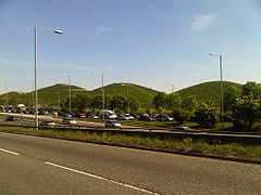
Northala Fields in Northolt (view from A40)
 Northolt
Northolt shown within Greater LondonOS grid reference TQ135845 London borough Ceremonial county Greater London Region London Country England Sovereign state United Kingdom Post town NORTHOLT Postcode district UB5 Dialling code 020 Police Metropolitan Fire London Ambulance London EU Parliament London UK Parliament Ealing North London Assembly List of places: UK • England • London Northolt is a town in the London Borough of Ealing, England. The town has London Underground and Network Rail stations and is on the A40 road. It is served by a number of London Bus routes.
Contents
History
The settlement of Northolt is located in the ancient county of Middlesex and is mentioned in the Domesday Book as being held by Geoffrey de Mandeville,and archaeological evidence suggests that there was a Saxon village at the location from the 8th century onwards. The medieval village had its origins in the Saxon period and is recorded in the Domesday Book. Up to late Victorian times, the area was rural with predominantly arable crops being grown. A 14th century moated manor existed behind the present Court Farm Road and was excavated from 1950 onwards. A barn constructed in the area in 1595 can now be seen in the Chiltern Open Air Museum. In the early part of the 18th century farmland was enclosed in order to provide hay for the City of London, alongside more traditional crops such as peas and beans.
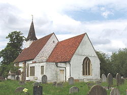 St Mary's Church, built in the 15th century, and located in the village
Suburban development began in the 1920s. Most of the housing north of the Western Avenue was built in the 1920s-1930s, and is in the private housing sector. Most of the housing built to the south of the Western Avenue was built in the 1960s-1970s, and is in the public/social housing sectors, particularly along the Kensington and Ruislip Roads.
Two important transport links run through Northolt: the Grand Union Canal and the modern A40 road.
In the 21st century, a new large private housing development was built on the former site of the Taylor Woodrow company, adjacent to the Grand Union Canal. This development is known as "Grand Union Village" and incorporates a new canal boat marina.
Local landmarks include St Mary the Virgin church and a clock tower erected to commemorate the coronation of King George VI. The former old village centre survives. On viewing St Mary's church from the village green, one could believe that one was still in a rural village.
Local landmarks
 Farrier Road apartments, part of Smith's Farm estate, at the bank of the Grand Union Canal
- St Mary the Virgin church (14th century) stands on the hill overlooking the old village. The Welsh poet Goronwy Owen was briefly a curate here. Bishop Samuel Lisle is buried here.
- In the centre of the village is a freestanding clock tower erected to commemorate the coronation of George VI in 1937.
 Northolt Green Clock
- The White Hart public house is on the site of a very old coaching inn. The roundabout immediately south of it is on the junction of the A312 (Church Road and Hayes Bypass) with the A4180 (Ruislip Road and West End Road). The Yeading Lane also joins the roundabout.
- Willow Cottages on the village green are said to have been built from bricks from the old manor house, which once stood behind the parish church.
- The two towers of the disused RAF radio station north of the town are situated in the Wood End wireless station recreation ground, which is bordered on all sides by housing (Bayshill Rise, Lancaster Road, Blenheim road). The location is now home to a National Air Traffic Control base.
- Northala Fields is a large area alongside the A40 road which has been redeveloped as an extension to the Northolt and Greenford Country Park. The development consists of four large, man-made conical hills (built of rubble from the first Wembley Stadium), which act as a sound barrier to block traffic noise from the Western Avenue. Behind the mounds are new ponds and a visitor centre. Two car parks for Northala Fields are available: one off Kensington Road, the other off the southern slip road between the A40 and The Target roundabout. There is no direct access (eastbound or westbound) from the A40. Access from the A40 is eastbound from The Target Roundabout; take the slip road down towards Kensington Road.
- The Larkspur Rovers F.C. clubhouse in Rowdell Road, Northolt, is a striking building to passers-by.
- There is a village community centre building in Ealing Road, opposite St Mary's church, which incorporates an open air miniature railway.
- A leisure centre, incorporating a pool, a fitness centre, a community hall and a library was built on the site of the former Swimarama swimming pool at the junction of Mandeville Road and Eastcote Lane North, and opened in 2010.[1]
 A40 Western Avenue, taken from near Islip Manor
Population
While Northolt remained a rural, agricultural area in the 19th century, its population growth remained slow:
- 1801 - 336 inhabitants
- 1871 - 479
- 1921 - 904
- 1961 - 26,000[2]
- 1991 - 32,000
The rapid growth of the population in the mid-20th century can be explained by Northolt's growth as a dormitory town for nearby Ealing, and the construction in 1935 of the A40 road through the area. Modern family homes were built in the 1920s and 1930s. In the 1950s and 1960s, predominantly local authority rented housing was constructed. 3,423 council houses had been built in Northolt by 1963. Northolt tube station was opened in 1948 to serve the growing population of the area.
 Racecourse Estate: this area was used for horse racing in the early 20th century
Pony racing
Northolt was famous for the pony racing which took place in Northolt Park. A one and a half mile (2.4 km) racecourse was constructed by Sir William Bass and Viscount Lascelles, and opened in 1929 by the Earl of Harewood and his wife the Princess Royal. During World War II the land was taken over and used as an army depot and prisoner of war camp. Despite numerous attempts to revive pony racing after the war the land was given over to housing construction. The Racecourse Estate was constructed between 1951 and 1955 in order to solve a severe housing shortage within the borough. The gates of the original racecourse remain in Petts Hill, and a section of the track can be observed as a long, flat stretch of land alongside Mandeville Road.
 The end roundabout of Islip Manor Road right next to the A40, located in the housing village of Islip Manor. This is the terminus of bus route E10
RAF Northolt
Main article: RAF NortholtThe Royal Air Force has a station near Northolt. Sometimes called Northolt Aerodrome, it is situated in the neighbouring town of South Ruislip in the London Borough of Hillingdon. Most early RAF airfields were named after the nearest railway station; in this case Northolt Junction, (now South Ruislip).
Transport
- Northolt tube station, on the Central line, London Underground
- Northolt Park railway station, on Chiltern Railways
Several London Buses routes serve Northolt: 90, 120, 140, 282, 395, E10 and night-route N7.
Northolt has good connections with South Harrow and Yeading. There is one route that goes to Eastcote and near South Ruislip. One infrequent route goes to Greenford Green and Greenford station. There is no bus that goes to Sudbury.
 Houses in Dolphin Road
Education
- Northolt High School, a specialist Technology College
- West London Academy
- Gifford Primary
- Greenwood Primary
- Petts Hill Primary
- St.Raphael's Catholic Primary School
- Willow Tree Primary
Political representation
The constituency of Ealing North is currently represented by Labour Party Member of Parliament Stephen Pound, and has been since 1997.
Northolt is made up of two electoral wards (Northolt Mandeville and Northolt West End), as well as part of the electoral ward of North Greenford, which elect councillors to Ealing Council. As of 6 May 2010 the area is represented by five Labour councillors (three in West End and two in Mandeville) and one Conservative councillor.
At the same election Labour took control of Ealing Council from the Conservatives with a major swing against the Tories, which conflicted with the nationwide swing in the General Election.
Northolt comes under the London Assembly constituency of Ealing and Hillingdon which has one assembly member, currently Richard Barnes (Conservative), who was re-elected in May 2008.
Political status on Ealing Council:
- Labour: 40 seats
- Conservative: 24 seats
- Liberal Democrats: 5 seats
Nearest places
- Greenford
- Greenford Green
- North Greenford
- Sudbury Hill
- Yeading
Neigbouring areas
Neighbouring areas of Northolt 
South Ruislip South Harrow Sudbury Hill North Hillingdon* 
Greenford Green  Northolt

Yeading Southall Greenford * excluding RAF Northolt (Aerodrome)
Notable people
- Human billboard Stanley Green (1915-1993) lived in Northolt
- Musician Alton Ellis (1938-2008), "Godfather of Rocksteady", lived in Northolt
- Musician Paul Gardiner (1958-1984), bass player in Gary Numan's Tubeway Army, died in Northolt
- Footballer Steve Perryman, remembered for his successes with Tottenham Hotspur (and locally for his sports outlets), was born in Ealing and grew up in Northolt
- Artist Paul Kidby, known for his association with author Terry Pratchett's Discworld, was born in Northolt
- Michael Colclough, Canon Pastor at St Paul's Cathedral and Deputy Priest in Ordinary to The Queen, was Archdeacon of Northolt 1992-4
Northolt on television
- The popular BBC comedy series My Hero, produced between 2000 and 2006, and featuring Ardal O'Hanlon and Emily Joyce, was set in Northolt.
- An episode of the popular CBBC series Tracy Beaker had scenes filmed in the old Swimarama swimming pool.
- A faux documentary titled Ghostwatch, aired on Halloween in 1992, was filmed in Northolt. Ghostwatch, the tale of a single mother haunted in her Northolt home by a mysterious figure called "Pipes", was taken by many anxious viewers to be a genuine documentary.
References
- ^ "Facility improvement projects". London Borough of Ealing. http://www.ealing.gov.uk/services/leisure/sports_and_leisure/facility_improvement_projects/. Retrieved 2009-03-15.
- ^ http://www.ealing.gov.uk/services/leisure/tourism/northolt/ ealing.gov
Sources
External links
Categories:- Districts of London
- Districts of Ealing
- Districts of London listed in the Domesday Book


Wikimedia Foundation. 2010.