- Livingston Island
Infobox Islands
name = Livingston
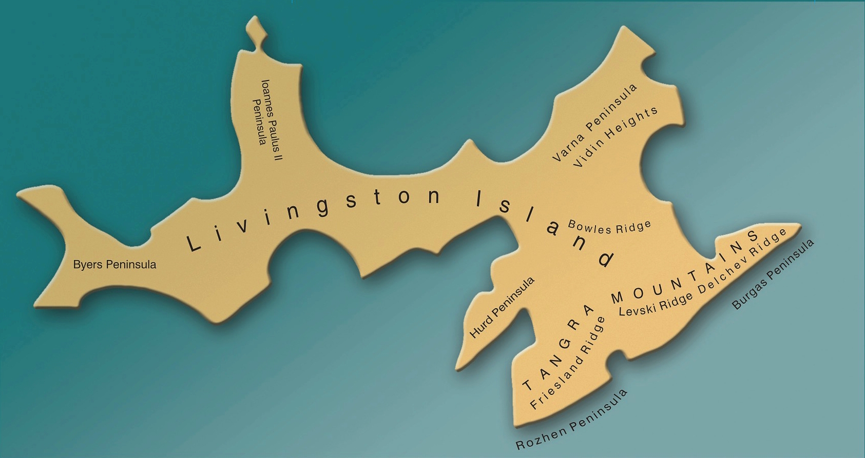
image caption = Map of Livingston Island, Antarctica
locator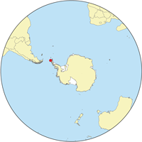
map_custom = no
nickname =
location =Antarctica
coordinates = coord|62|36|S|60|30|W|display=inline
archipelago =South Shetland Islands
total islands =
major islands =
area = convert|974|km2|sqmi|0|abbr=on
length = convert|73|km|mi|0|abbr=on
width = convert|34|km|mi|0|abbr=on
highest mount = Mt Friesland
elevation = convert|1700|m|ft|0|abbr=on
population =
population as of =
density =
ethnic groups =
country = Antarctica
additional info = Administered under theAntarctic Treaty System Livingston Island (coord|62|36|S|60|30|W|) is an Antarctic island in the
South Shetland Islands ,Western Antarctica lying between Greenwich andSnow Island s. Thisisland was known to sealers as early as 1819, and the name Livingston has been well established in international usage for over 180 years.Geography
Livingston is situated in the
Southern Ocean 110 km to the northwest of Cape Roquemaurel on the Antarctic mainland, 830 km to the south-southeast ofCape Horn inSouth America , 820 km to the southeast of theDiego Ramirez Islands (the southernmost land ofSouth America ), 1000 km due south of theFalkland Islands , 1600 km to the southwest ofSouth Georgia Island , and 3000 km from theSouth Pole .The Island is part of theSouth Shetlands archipelago, an islands chain extending over 500 km in east-northeast to west-southwest direction, and separated from the nearbyAntarctic Peninsula byBransfield Strait , and fromSouth America by theDrake Passage . TheSouth Shetlands cover a total land area of 3687 km² comprising (from east to west) Clarence Island,Elephant Island ,King George Island , Nelson Island,Robert Island ,Greenwich Island , Livingston Island,Deception Island ,Snow Island , Low Island and Smith Island, as well as numerous smaller islets and rocks. Livingston is separated from the neighbouringGreenwich Island to the east andSnow Island to the west-southwest respectively byMcFarlane Strait and byMorton Strait .Deception Island , located barely 18 km southwest of Livingston’sBarnard Point in theBransfield Strait , is a volcano whosecaldera forms the sheltered harbour of Port Foster entered by a single narrow passage known as Neptunes Bellows.The Island extends 73 km from Start Point in the west to
Renier Point in the east, its width varying from 5 km at the neck between South Bay andHero Bay to 34 km betweenBotev Point to the south andWilliams Point to the north, with surface area of 974 km². There are many islets and rocks in the surrounding waters, particularly off the north coast. More sizable among the adjacent smaller islands are Rugged Island offByers Peninsula , Half Moon Island inMoon Bay and Desolation Island inHero Bay to the north.Ice cliffs, often withdrawing in the recent decades to uncover new coves, beaches and points, form most of the coastline. Except for isolated patches the land surface is covered by an ice cap, highly crevassed in certain segments, with ice domes and plateaus in the central and western areas, and a number of valley glaciers formed by the more mountainous relief of eastern Livingston. Typical of the Island’s glaciology are the conspicuous ash layers originating from volcanic activity on the neighbouring
Deception Island .Apart from the extensive
Byers Peninsula (61 km²) forming the west extremity of Livingston, the ice-free part of the island includes certain coastal areas atCape Shirreff ,Siddons Point ,Hannah Point ,Williams Point ,Hurd Peninsula andRozhen Peninsula , as well as slopes in the mountain ranges, and ridges and heights in eastern Livingston that are too precipitous to keep snow. The principal mountain formations includeTangra Mountains (30 km long, with Mt Friesland rising to 1700 m),Bowles Ridge (6.5 km, elevation 822 m),Vidin Heights (8 km, 604 m),Burdick Ridge (773 m),Melnik Ridge (696 m) andPliska Ridge (667 m).The coastline of the island is irregular, with the more significant indentations of South Bay, False Bay,
Moon Bay , Hero, Barclay, New Plymouth, Osogovo and Walker, and the peninsulas of Hurd (extension 10 km), Rozhen (9 km), Burgas (10,5 km), Varna (12 km), Ioannes Paulus II (12.8 km) and Byers (15 km).The local variety of the
Antarctic Peninsula weather is particularly changeable, windy, humid and sunless; says Australian mountaineer Damien Gildea: ‘Livingston got just about the worst weather in the world’. Whiteouts are common, and blizzards can occur at any time of the year. Temperatures are rather constant, rarely exceeding 3°C in summer or falling below –11°C in winter, with wind chill temperatures up to 5-10°C lower.Below are the average temperatures of the warmest month, coldest month, yearly average, and the average annual rainfall of Livingston Island compared with some other locations
Livingston Island (coastal areas): 1.3°C (34.3°F), –7°C (19.4°F), –2.7°C (27.1°F), 800 mm (31.5 inches);
London : 17°C (62.6°F), 3.9°C (39°F), 9.9°C (49.8°F), 611 mm (24 inches).Cherni Vrah (peak rising to 2,290 m just 6.5 km fromSofia ): 8.6°C (47.5°F), –8.1°C (17.4°F), 0.1°C (32.2°F), 1,178 mm (46.4 inches);Sofia : 20.1°C (68.2°F), –1.1°C (30°F), 9.9°C (49.8°F), 575 mm (22.6 inches).History
It was only in the Nineteenth century that any land was discovered in what today is ‘political’
Antarctica , and that land happened to be Livingston Island. Captain William Smith in the English merchant brig "Williams", while sailing toValparaiso in 1819 deviated from his route south ofCape Horn , and on 19 February sighted the northeast extremity of Livingston,Williams Point .A few months later Smith revisited theSouth Shetlands to land onKing George Island on 16 October 1819 and claim possession for Britain. In the meantime, a Spanish vessel had been damaged by severe weather in theDrake Passage and sunk off the north coast of Livingston in September 1819. The 74-gun "San Telmo" commanded by Captain Rosendo Porlier was the flagship of a Spanish naval squadron. The more than 600 men lost onboard the "San Telmo" were the first recorded people to die inAntarctica . While no one survived, parts of her wreckage were found subsequently by sealers on Half Moon Beach,Cape Shirreff .In December 1819 William Smith returned with his ship to the
South Shetlands . This time he was chartered by CaptainWilliam Shirreff , British commanding officer in thePacific stationed inChile , and accompanied by LieutenantEdward Bransfield who was tasked to survey and map the new lands. On 30 January 1820 they sighted the mountains of theAntarctic Peninsula , unaware that three days earlier the continent had already been discovered by the Russian Antarctic expedition of Fabian Gottlieb Thaddeus von Bellingshausen and Mihail Lazarev.One year later, the Russians had circumnavigated Antarctica and arrived in theSouth Shetlands region in January 1821 to find over 50 American and English sealing vessels and 1000 men taking hundreds of thousands of fur seal skins. While sailing betweenDeception Island and Livingston (namedSmolensk by the Russians) Bellingshausen met the American CaptainNathaniel Palmer , yet another pioneer of Antarctic exploration who himself had sighted the mainland in the previous November. Remains of huts and sealer artefacts are still found on Livingston, which possesses the second greatest concentration of historical sites inAntarctica (after South Georgia). The names of many geographical features on the Island also refer to its early history. Among the commemorated are ship captains such as the Americans Christopher Burdick, Charles Barnard, Robert Johnson, Donald MacKay, Robert Inott, David Leslie, Benjamin Brunow, Robert Macy, Prince Moores and William Napier, the Britons William Shirreff, M’Kean, John Walker, Ralph Bond, Christopher MacGregor, T. Binn and William Bowles, the Australian Richard Siddons, people like the New York shipownerJames Byers , the American whaling merchants William and Francis Rotch, British Admiralty hydrographer Thomas Hurd, and John Miers, publisher of the first chart of theSouth Shetland Islands based on the work of William Smith, or sealing vessels like "Huron", "Williams", "Samuel", "Gleaner", "Huntress", "Charity", "Hannah", "Henry", "John", "Hero" and others. Some of the place names given by the Nineteen Century sealers are descriptive, such asDevils Point ,Hell Gates andNeck or Nothing Passage , hazardous places where ships and people were lost;Inept Cove ,Needle Peak , or theRobbery Beaches where American sealers were robbed of their sealskins by the British. However, names like Livingston,Mount Friesland andRenier Point also go back to the first few seasons after the discovery of the islands yet their particular origins remain unknown.cientific bases
The permanent scientific bases of Juan Carlos I (
Spain ) and St. Kliment Ohridski (Bulgaria ) were established in 1988 at South Bay. Other base facilities are the smallShirreff Base (or Guillermo Mann,Chile and theU.S.A. ) onCape Shirreff since 1991, and the inactive base Cámara (Argentina ) on Half Moon Island since 1953. Occasional field camps support research in remote areas of the Island.Camp Byers (Spain ) operates regularly nearNikopol Point on Byers Peninsula, and theCamp Academia site situated at elevation 541 m in upperHuron Glacier ,Wörner Gap area served as a base camp of theTangra 2004/05 topographic survey.Camp Academia is accessible by 11-12.5 km routes from St. Kliment Ohridski and Juan Carlos I respectively, and offers convenient overland access toTangra Mountains to the south;Bowles Ridge ,Vidin Heights ,Kaliakra Glacier andSaedinenie Snowfield areas to the north;Huron Glacier to the east; andPerunika Glacier andHuntress Glacier to the west.Camp Academia was named for theBulgarian Academy of Sciences in appreciation of Academy’s contribution to the Antarctic exploration, and has been designated as the summer post office Tangra 1091 of theBulgarian Posts since 2004.Protected areas
In order to protect Antarctica the
Antarctic Treaty system enforces a strict general regime regulating human presence and activities on the continent, and designates certain protected territories where access is allowed only for scientific purposes, and with special permission.There have been two such
nature reserve s on Livingston Island since 1966, comprising respectively the extensiveByers Peninsula , and the small peninsula ofCape Shirreff together withSan Telmo Island and adjacent waters.Subject of protection are the fossils demonstrating the link between Antarctica and other austral continents, a variety of abundant flora and fauna including colonies of seals and penguins that are the subject of scientific study and monitoring, as well as numerous historical monuments dating from the Nineteenth century.
Tourism
Antarctic shipborne
tourism was initiated in 1958 in theSouth Shetland Islands . Since then the number of tourists visitingAntarctica has grown to tens of thousands annually, of whom over 95% tour theSouth Shetlands and the nearbyAntarctic Peninsula .Hannah Point on the south coast of Livingston and Half Moon Island off the east coast, as well as the nearbyDeception Island and theAitcho Islands nearGreenwich Island are among the most popular destinations frequented bycruise ship s, offering walks amidst spectacular scenery and amazingwildlife .ee also
*
St. Kliment Ohridski Base
*Juan Carlos I Base
*Camp Academia
*Camp Byers
*Antarctic Place-names Commission
*List of Bulgarian toponyms in Antarctica
*Tangra Mountains
* Tangra 2004/05 Expedition
*South Shetland Islands References
* L.L. Ivanov et al, (from English Strait to Morton Strait, with illustrations and ice-cover distribution), 1:100000 scale topographic map, Antarctic Place-names Commission of Bulgaria, Sofia, 2005
* Text authorized for publication in Wikipedia by the [http://apc.mfa.government.bg Antarctic Place-names Commission of Bulgaria] .External links
* [http://www.70south.com/resources/islands/shetland 70south - more information on the South Shetland Islands including Livinston Island]
* [http://www.tangra2004bg.org/ Expedition Tangra 2004/05]
* [http://www.utm.csic.es/bae.asp Spanish base Juan Carlos I]
* [http://www.theomegafoundation.org/livingston03.htm Expedition Omega Livingston 2003]
* [http://www.cep.aq/apa/aspa/sites/aspa126/ Protected area Byers Peninsula]
* [http://www.cep.aq/apa/aspa/sites/aspa149/ Protected area Cape Shirreff]
Wikimedia Foundation. 2010.