- Oregon County, Missouri
-
Oregon County, Missouri 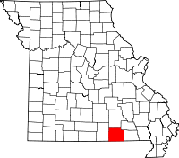
Location in the state of Missouri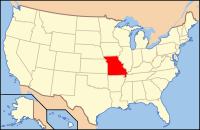
Missouri's location in the U.S.Founded 1845 Named for Oregon Territory Seat Alton Largest city Thayer Area
- Total
- Land
- Water
791.59 sq mi (2,050 km²)
791.40 sq mi (2,050 km²)
0.18 sq mi (0 km²), 0.02%PopulationEst.
- (2008)
- Density
10,264
13/sq mi (5/km²)Time zone Central: UTC-6/-5 Oregon County is a county located in South Central Missouri in the United States. As of the 2000 U.S. Census, the county's population was 10,344. A 2008 estimate, however, showed the population to be 10,264. Its county seat is Alton[1]. The county was officially organized on February 14, 1845, and was named for the Oregon Territory in the northwestern United States.
Home to a large area of the Mark Twain National Forest, Oregon County contains more National Forest land than any other county in Missouri. It also contains the Irish Wilderness, the largest federally protected wilderness area in the state. Hiking and backpacking opportunities abound on the Ozark Trail and the White's Creek Trail. Canoeing and fishing are popular on the Eleven Point River, which is Missouri's only National Wild and Scenic River.
Grand Gulf State Park is a Missouri state park just west of Thayer which includes a collapsed karst canyon.
Contents
Geography
According to the 2000 census, the county has a total area of 791.59 square miles (2,050.2 km2), of which 791.40 square miles (2,049.7 km2) (or 99.98%) is land and 0.18 square miles (0.47 km2) (or 0.02%) is water.[2]
Adjacent counties
- Shannon County (north)
- Carter County (northeast)
- Ripley County (east)
- Randolph County, Arkansas (southeast)
- Sharp County, Arkansas (south)
- Fulton County, Arkansas (southwest)
- Howell County (west)
Major highways
National protected area
- Mark Twain National Forest (part)
History
During the American Civil War, men from Oregon County marched off to fight for the Confederate States of America on three separate occasions.
In July 1861, the Second Infantry Regiment of McBride's Seventh Division, Missouri State Guard was formed. Oregon County men made up Companies A, D, F, and G. On August 10, 1861 they fought at the Battle of Wilson's Creek near Springfield and were victorious.
In early 1862 the Missouri State Guard was disbanded and regular Confederate Army units were formed. During February and March 1862, Oregon County men were mustered into companies D and I of the Fourth Missouri Infantry. The Fourth Missouri was sent to Mississippi where they engaged in the Battle of Corinth on October 3-4, 1862. The valiant Oregon County men suffered heavy losses to disease and battle casualties and finally surrendered with 30,000 other Confederates at the Siege of Vicksburg on July 4, 1863.
In the late winter and spring of 1864, Major Matthew G. Norman began organizing another regiment of troops. These men would join Northern Arkansas men led by Lt. Colonel James H. Tracy to form Fristoe's Regiment in the Missouri Cavalry. Colonel Edward T. Fristoe of Rappahannock, Virginia would lead his command on the ill-fated Missouri Invasion of General Sterling Price in the fall of 1864.
Other units that Oregon County men joined were the Freeman's Regiment, the Missouri Cavalry, and the Fifteenth Missouri Cavalry Regiment from neighboring Ripley County. Only a handful of Oregon County men joined the Union Army. The county suffered greatly during the war from raids of Union troops as well as the atrocities of bushwhackers.
Education
Of adults 25 years of age and older in Oregon County, 72.0% possesses a high school diploma or higher while 9.1% holds a bachelor's degree or higher as their highest educational attainment.
Public Schools
- Alton R-IV School District - Alton
- Alton Elementary School (K-06)
- Alton High School (07-12)
- Couch R-I School District - Myrtle
- Couch Elementary School (K-06)
- Couch High School (07-12)
- Oregon-Howell R-III School District - Koshkonong
- Koshkonong Elementary School (K-06)
- Koshkonong High School (07-12)
- Thayer R-II School District - Thayer
- Thayer Elementary School (K-06)
- Thayer High School (07-12)
Religion
According to the Association of Religion Data Archives County Membership Report (2000), OregonCounty is a part of the Bible Belt with evangelical Protestantism being the majority religion. The most predominant denominations among residents in Oregon County who adhere to a religion are Southern Baptists (36.10%), National Association of Free Will Baptists (34.45%), and Churches of Christ (9.81%).
Demographics
As of the census[3] of 2000, there were 10,344 people, 4,263 households, and 3,018 families residing in the county. The population density was 13 people per square mile (5/km²). There were 4,997 housing units at an average density of 6 per square mile (2/km²). The racial makeup of the county was 94.61% White, 0.10% Black or African American, 2.88% Native American, 0.14% Asian, 0.01% Pacific Islander, 0.08% from other races, and 2.19% from two or more races. Approximately 1.09% of the population were Hispanic or Latino of any race. Among the major first ancestries reported in Oregon County were 29.7% American, 13.4% English, 13.1% Irish, and 13.0% German, according to Census 2000.
There were 4,263 households out of which 29.30% had children under the age of 18 living with them, 58.80% were married couples living together, 8.40% had a female householder with no husband present, and 29.20% were non-families. 26.20% of all households were made up of individuals and 13.90% had someone living alone who was 65 years of age or older. The average household size was 2.40 and the average family size was 2.86.
In the county the population was spread out with 24.30% under the age of 18, 7.00% from 18 to 24, 24.10% from 25 to 44, 26.50% from 45 to 64, and 18.00% who were 65 years of age or older. The median age was 41 years. For every 100 females there were 96.40 males. For every 100 females age 18 and over, there were 92.80 males.
The median income for a household in the county was $26,119, and the median income for a family was $31,637. Males had a median income of $22,304 versus $16,353 for females. The per capita income for the county was $15,043. About 16.30% of families and 22.00% of the population were below the poverty line, including 28.20% of those under age 18 and 20.00% of those age 65 or over.
Cities and towns
Politics
Local
Politics at the local level in Oregon County is predominantly controlled by the Democratic Party. In fact, all but two of Oregon County's elected officeholders are Democrats.
Office Incumbent Party Assessor Charles Lon Alford Democratic Circuit Clerk & Ex Officio Recorder Dorothy Barton Democratic Clerk Gary Hensley Democratic Collector Jerry Richardson Democratic Commissioner – District 1 Johnny D. Wrenfrow Democratic Commissioner – District 2 Edward Casey Republican Coroner Tom Clary Democratic Presiding Commissioner Leo Warren Democratic Prosecuting Attorney Fred O’Neill Democratic Public Administrator Mike Crawford Republican Sheriff George Underwood Democratic Surveyor Scott Simer Democratic Treasurer Kim Hollis Democratic State
Past Gubernatorial Elections Results Year Republican Democratic Third Parties 2008 38.07% 1,742 59.22% 2,710 2.71% 124 2004 55.76% 2,579 42.16% 1,950 2.08% 96 2000 45.82% 1,938 51.70% 2,187 2.48% 105 1996 38.02% 1,466 59.23% 2,284 2.75% 106 In the Missouri House of Representatives, all of Oregon County is a part of Missouri’s 153rd District and is currently represented by Mike Dethrow (R-Alton). Dethrow is term limited and is finishing out his last term. He will be succeeded by fellow Republican Steve Cookson in the next legislative session in January 2011.
Missouri House of Representatives - District 153 - Oregon County (2010) Party Candidate Votes % ±% Republican Steve Cookson 2,133 61.52 -38.48 Democratic George Meyers 1,175 33.89 +33.89 Constitution Rory Calhoun 159 4.59 +4.59 In the Missouri Senate, all of Oregon County is a part of Missouri's 33rd District and is currently represented by State Senator Chuck Purgason (R-Caulfield). In 2008, Purgason defeated Eric Reeve (D) 67.31-32.69 percent in the district. The 33rd Senatorial District consists of Camden, Howell, Laclede, Oregon, Shannon, Texas, and Wright counties.
Missouri Senate - District 33 - Oregon County (2008) Party Candidate Votes % ±% Republican Chuck Purgason 2,709 61.03 Democratic Eric Reeve 1,730 38.97 Federal
In the U.S. House of Representatives, Oregon County is represented by Jo Ann Emerson (R-Cape Girardeau) who represents all of Southeast Missouri as part of Missouri's 8th Congressional District.
U.S. House of Representatives - District 8 - Oregon County (2010) Party Candidate Votes % ±% Republican Jo Ann Emerson 2,150 61.04 -5.03 Democratic Tommy Sowers 1,218 34.58 +3.27 Independent Larry Bill 79 2.24 +2.24 Libertarian Rick Vandeven 75 2.13 +0.77 Political Culture
Past Presidential Elections Results Year Republican Democratic Third Parties 2008 57.77% 2,652 39.45% 1,811 2.78% 128 2004 59.26% 2,769 39.01% 1,823 1.73% 81 2000 59.56% 2,521 37.04% 1,568 3.40% 144 1996 39.10% 1,502 46.73% 1,795 14.16% 544 At the presidential level, Oregon County is a fairly independent-leaning or battleground county. While George W. Bush carried Oregon County in 2000 and 2004, the margins of victory were smaller than in many of the other rural areas. Bill Clinton also carried Oregon County both times in 1992 and 1996. Like most of the other rural counties in Missouri, Oregon County favored John McCain over Barack Obama in 2008.
Like most rural areas throughout Southeast Missouri, voters in Oregon County generally adhere to socially and culturally conservative principles. In 2004, Missourians voted on a constitutional amendment to define marriage as the union between a man and a woman—it overwhelmingly passed Oregon County with 87.09 percent of the vote. The initiative passed the state with 71 percent of support from voters as Missouri became the first state to ban same-sex marriage. In 2006, Missourians voted on a constitutional amendment to fund and legalize embryonic stem cell research in the state—it failed in Oregon County with 56.78 percent voting against the measure. The initiative narrowly passed the state with 51 percent of support from voters as Missouri became one of the first states in the nation to approve embryonic stem cell research. Despite Oregon County’s longstanding tradition of supporting socially conservative platforms, voters in the county have a penchant for advancing populist causes like increasing the minimum wage. In 2006, Missourians voted on a proposition (Proposition B) to increase the minimum wage in the state to $6.50 an hour—it passed Oregon County with 73.14 percent of the vote. The proposition strongly passed every single county in Missouri with 75.94 percent voting in favor as the minimum wage was increased to $6.50 an hour in the state. During the same election, voters in five other states also strongly approved increases in the minimum wage.
Missouri Presidential Preference Primary (2008)
In the 2008 Missouri Presidential Preference Primary, voters in Oregon County from both political parties supported candidates who finished in second place in the state at large and nationally.
- Former U.S. Senator Hillary Rodham Clinton (D-New York) received more votes, a total of 989, than any candidate from either party in Oregon County during the 2008 Missouri Presidential Preference Primary.
Oregon County, Missouri 2008 Republican primary in Missouri John McCain 242 (20.47%) Mike Huckabee 696 (58.88%) Mitt Romney 134 (11.34%) Ron Paul 101 (8.54%) Oregon County, Missouri 2008 Democratic primary in Missouri Hillary Rodham Clinton 989 (71.77%) Barack Obama 332 (24.09%) John Edwards (withdrawn) 42 (3.05%) See also
- National Register of Historic Places listings in Oregon County, Missouri
References
- ^ "Find a County". National Association of Counties. http://www.naco.org/Counties/Pages/FindACounty.aspx. Retrieved 2011-06-07.
- ^ "Census 2000 U.S. Gazetteer Files: Counties". United States Census. http://www.census.gov/tiger/tms/gazetteer/county2k.txt. Retrieved 2011-02-13.
- ^ "American FactFinder". United States Census Bureau. http://factfinder.census.gov. Retrieved 2008-01-31.
External links
- Digitized 1930 Plat Book of Oregon County from University of Missouri Division of Special Collections, Archives, and Rare Books

Shannon County Carter County Howell County 
Ripley County  Oregon County, Missouri

Fulton County, Arkansas Sharp County, Arkansas Randolph County, Arkansas Municipalities and communities of Oregon County, Missouri Cities Alton | Koshkonong | Thayer

Townships Big Apple | Billmore | Black Pond | Cedar Bluff | Couch | Falling Spring | Goebel | Highland | Jeff | Jobe | Johnson | King | Moore | Myrtle | Ozark | Piney | Thayer | Woodside
Unincorporated
communitiesBardley | Couch | Myrtle | Thomasville
Categories:- Missouri counties
- Oregon County, Missouri


Wikimedia Foundation. 2010.