- County Kildare
-
County Kildare
Contae Chill Dara
Coat of armsMotto: Meanma agus Misneach (Irish)
"Spirit and Courage"Location in Ireland
Coordinates: 53°10′N 6°45′W / 53.167°N 6.75°WCoordinates: 53°10′N 6°45′W / 53.167°N 6.75°W Country Ireland Province Leinster County town Naas Government – Type County Council – Dáil Éireann Kildare North
Kildare South– European Parliament East Area – Total 1,693 km2 (653.7 sq mi) Area rank 24th Population (2011) 209,955 – Rank 7th Code KE Website kildare.ie County Kildare (Irish: Contae Chill Dara) is a county in Ireland. It is part of the Mid-East Region and is also located in the province of Leinster. It is named after the town of Kildare. Kildare County Council is the local authority for the county. The population of the county is 209,955 according to the 2011 census.
Contents
Geography and political subdivisions
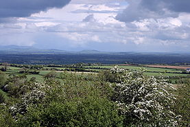 Looking east across the broad plains of South Kildare to the distant Wicklow Hills.
Kildare is the 24th largest of Ireland’s thirty-two counties in area and seventh largest in terms of population.[1] It is the eighth largest of Leinster’s twelve counties in size, and second largest in terms of population. It is bordered by the counties of Carlow, Laois, Meath, Offaly, Dublin and Wicklow. As an inland county, Kildare is a generally lowland region. The county's highest points are the foothills of the Wicklow Mountains bordering to the east. The highest point in Kildare is Cupidstown Hill on the border with Dublin, with the better known Hill of Allen in central Kildare.
Towns and villages
Historical populations Year Pop. ±% 1653 11,983 — 1659 13,825 +15.4% 1788 71,570 +417.7% 1813 85,000 +18.8% 1821 99,065 +16.5% 1831 108,424 +9.4% 1841 114,488 +5.6% 1851 95,723 −16.4% 1861 90,946 −5.0% 1871 83,614 −8.1% 1881 75,804 −9.3% 1891 70,206 −7.4% 1901 63,566 −9.5% 1911 66,627 +4.8% 1926 58,028 −12.9% 1936 57,892 −0.2% 1946 64,849 +12.0% 1951 66,437 +2.4% 1956 65,915 −0.8% 1961 64,420 −2.3% 1966 66,404 +3.1% 1971 71,977 +8.4% 1979 97,185 +35.0% 1981 104,122 +7.1% 1986 116,247 +11.6% 1991 122,656 +5.5% 1996 134,992 +10.1% 2002 163,944 +21.4% 2006 186,335 +13.7% 2011 209,955 +12.7% [2] - Allen
- Allenwood
- Ardclough
- Athy
- Ballitore
- Ballymore Eustace
- Calverstown
- Caragh
- Carbury
- Castledermot
- Clane
- Coill Dubh
- Celbridge
- Derrinturn
- Eadestown
- Hawkfield
- Johnstown
- Kilberry
- Kilcock
- Kilcullen
- Kildangan
- Kill
- Kilmead
- Kilmeague
- Kilteel
- Kildare
- Leixlip
- Lullymore
- Maynooth
- Milltown
- Moone
- Monasterevin
- Narraghmore
- Nurney
- Naas
- Newbridge
- Prosperous
- Rathangan
- Robertstown
- Sallins
- Straffan
- Staplestown
- Suncroft
- Timolin
Physical geography
The county has three major rivers running through it: the Barrow, the Liffey and the Boyne. The Grand Canal crosses the county from Lyons on the east to Rathangan and Monasterevin on the west. A southern branch joins the Barrow navigation at Athy. The Royal Canal stretches across the north of the county along the border with Meath. Pollardstown Fen is the largest remaining calcareous fen in Ireland, covering an area of 220 hectares and is recognised as an internationally important fen ecosystem with unique and endangered plant communities, and declared a National Nature Reserve in 1986.
The Bog of Allen is a large bog that extends across 958 km2 and into County Kildare, County Meath, County Offaly, County Laois, and County Westmeath. Kildare has 243 km2 of bog (almost 14% of Kildare's land area) mostly located in the south-west and north-west, a majority of this being Raised Bog. It is habitat to over 185 plant and animal species.
There are 8,472 hectares (20,934 acres) of Forested land in Kildare, accounting for roughly 5% of the county's total land area. 4,056 hectares of this is Coniferous, while there is 2,963 hectares of Broadleaf and the remaining area are Unclassified Species. Coillte and Dúchas currently own 47% of the forestry. Coillte run Donadea Forest Park which is in North-Central Kildare. The forest covers 259 hectares of mixed woodland (60% Broadleaf, 40% Conifer) and is the largest forest park in Kildare.
History
Main article: History of County KildareKildare was shired in 1297[3] and assumed its present borders in 1832, following amendments to remove a number of enclaves and exclaves.
The county was the home of the powerful Fitzgerald family. Parts of the county were also part of the Pale area around Dublin.
Local government
The whole county is governed at local authority level by Kildare County Council in Naas. Although the towns of Leixlip, Naas, Newbridge and Athy have separate Town Councils under the Local Government Act 2001. The Local Electoral Areas of Kildare are Athy (4 Seats), Celbridge (6 Seats), Clane (4 Seats), Kildare (6 Seats) and Naas (5 Seats). The Council has 25 members. The current council was elected in June 2009.
Politically the county is divided into two Dáil constituencies, Kildare North (four seats) and Kildare South (three seats). After the 2007 General Election, the TDs elected were; Bernard Durkan (FG), Emmet Stagg (Lab), Aine Brady (FF), Michael Fitzpatrick (FF), Sean O Fearghail (FF), Sean Power (FF) and Jack Wall (Lab).
The county falls within the Southern and Eastern region for certain European Union purposes. It is also a part of the Greater Dublin Area and the "Mid-East" Regional Authority.
Demographics
The county's population has nearly doubled to some 186,000 in 1990-2005. The north eastern region of Kildare had the highest average per-capita income in Ireland outside County Dublin in 2003. East Kildare's population has increased rapidly, for example the amount of housing in the Naas suburb of Sallins has increased sixfold since the mid 1990s. As from June 30th 2011 , the population of the county is 209,622. http://www.cso.ie/px/pxeirestat/Statire/SelectVarVal/saveselections.asp
Economy
 River Barrow and White's Castle, Athy.
Kildare currently (2010) contains the European base of electronics firms, Intel and Hewlett Packard, two of the largest employers in this sector in the entire island. Pharmaceutical giant Wyeth has its European Manufacturing base in Newbridge, with another plant in nearby Newcastle in County Dublin. Major pizza-making, soft drinks, and frozen food enterprises are located in Naas. Large supermarket distribution centres are located in Naas, Newbridge and Kilcock. Some of Ireland's most glamorous boutiques are in Naas such as the Emporium Kalu on Main Street Naas which is the most expensive boutique in Ireland. The county has numerous shopping malls in the main towns such as Manor Shopping centre in Maynooth, Kildare Village Outlet Shopping Centre in Kildare Town, Naas Shopping Mall under construction and the Whitewater Centre in Newbridge. The Irish Army's largest military base, its command headquarters, and its training centre are located at the Curragh. Allenwood and Timahoe are also the location of large peat burning power stations operated by the state, and Kildare has historically be an employment centre in this sector.
Kildare is the centre of the Irish horse industry.[citation needed] Kildare has more stud farms than any other county in Ireland, and three important racecources at Punchestown, near Naas, Naas Racecourse itself and at the leading flat national racecourse at the Curragh. Kildare is also home to the state owned Irish National Stud farm, the national equestrian centre in Kill, and Goff's equine auction centre (also in Kill). Most of Ireland's prominent show jumping competitors are located in, or come from county Kildare, especially the areas near Kilcock and Sallins.[citation needed] Several prominent international breeders have substantial stud farms in Kildare, including many from the Arab world.
County Kildare is the richest county in Ireland outside of Dublin and has the lowest unemployment rates in Ireland, throughout the economic recession of the 1980s. House prices in the county but especially in the North East of the county e.g. Naas and Maynooth have always been considerably higher than the other counties in the country outside Dublin. Kildare was the first county in Ireland to experience the Celtic Tiger economic boom in the early 1990s, mainly as a result of the decision of Intel to locate between Leixlip and Maynooth. From various high tech companies like Intel and Hewlett Packard the county is sometimes dubbed "the Silicon Valley of Europe", and had a pick up in construction that predated that of other counties.[citation needed]
The North and East parts of Kildare (Naas, Maynooth, Celbridge, Leixlip,Kilcock) is considered more of a industrial and suburban style area. It is the area where most economic development in the county takes place and is considered the more wealthier areas of the county, it is the more densely populated areas of Kildare. The NE part of the county e.g., Celbridge and Leixlip is considered in the Western Suburbs of Dublin.
The South and West parts of Kildare (Athy, Kildare, Newbridge, Monasterevin, Rathangan) is considered the more agriculturally dominated area in the county and is less populated then the more densely populated areas in the North and East of the county.
Transport
Road
County Kildare houses the hub of Ireland's network of major roads.
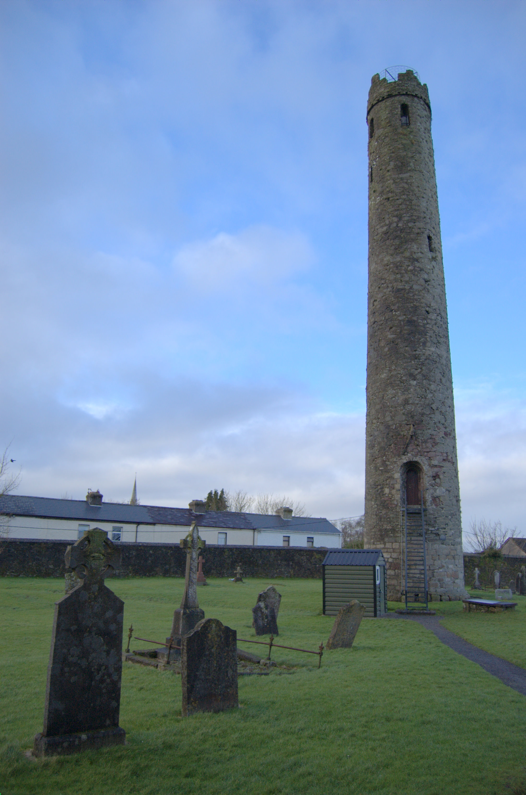
 A round tower at St. Brigid's Cathedral in Kildare.
The N4(M4) from Dublin to Sligo travels along the north of the county by-passing the towns of Leixlip, Maynooth and Kilcock.
The N7(M7) from Dublin to Limerick runs through the county and by-passes the towns of Naas, Newbridge, Kildare and Monasterevin. This road is colloquially referred to as the "Naas Dual carriageway" because when it was originally up-graded in 1964 the road from Dublin to Naas was a double lane carriageway, one of the first of its kind in Ireland.
The N9(M9) is another National Primary Route that commences at Kilcullen and ends at Waterford. It is motorway standard to Waterford, with a small gap of single lane carriageway between Carlow and Kilkenny (full motorway due for completion September 2010).
Rail
The County is also served by the trains connecting the Dublin to Munster, South Leinster, and South Connaught, with daily connections to Cork, Waterford, Limerick, and Galway. The principal Irish Rail intercity train station in the county is Kildare, however, Newbridge, Sallins and Hazelhatch are also served by a Dublin commuter train service called the Arrow.
Waterway
Kildare is the centre of Ireland's Grand Canal network built in the late 18th century. This connects Kildare with Waterford, Dublin, Limerick and Athlone. The Royal Canal runs west from Dublin and parts of it form the boundary with County Meath.
Education
- Two third-level educational institutions -- St. Patrick's College founded by King George III in 1795 to educate Ireland's Catholics and the National University of Ireland, Maynooth founded in 1997—are located in Maynooth. They share campus space and many facilities. The two institutions were formally separated in 1997. NUI Maynooth is the only university in the Republic of Ireland not situated in a city.
- Clongowes Wood College is a private secondary boarding school for boys, located near Clane. Founded by the Society of Jesus (The Jesuits) in 1814, it is one of Ireland's oldest Catholic schools.
- The town of Clane is home to another educational institute, Clane College, a provider of further education to the wider Kildare community.
- Newbridge College is a co-educational secondary school. The Dominican Order founded Newbridge College in 1852 as a boarding school for boys.
- Pipers Hill College Naas is a second level college opened in August 2009 to replace St. Patrick's Community College.
Music
- Bell X1 are from Celbridge, County Kildare
- Blood or Whiskey, punk rock/irish music band originate from Leixlip
- Luka Bloom is from Newbridge
- Joseph Doyle, bassist from Irish band The Frames is from Allenwood
- Graham Hopkins, drummer with The Frames, The Swell Season, and Therapy? is from Clane
- Damien Leith, Australian Idol 2006 winner and singer-songwriter lived in Milltown until he moved to Australia.
- Jack Lukeman, otherwise known as Jack L, is from Athy
- Donal Lunny was raised in Newbridge.
- MayKay, lead singer of Fight Like Apes, is a native of the county
- Miracle Bell, Indie-pop band, hail from Naas.
- Christy Moore, folk musician, was born in Newbridge.
- Paul Quinn, lead singer of the rock band No Sweat, hailed from Kilcock
- Liam O'Flynn from the band Planxty is from Kill
- Damien Rice was born in Celbridge
- Super Extra Bonus Party, Choice Music award winners, are from Newbridge
- Heidi Talbot is from Kill
- Rolling Stones guitarist Ron Wood owns a home in the area
Sport
GAA
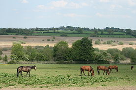 Horses near Pollardstown Fen.
The nickname for the Kildare GAA team is the Lilywhites, a reference to the all-white jerseys they wear.
In 1928, Kildare became the first team to win the Sam Maguire trophy for the All Ireland football Championship, defeating Cavan 2-6 to 2-5.
County Kildare is also known as the Shortgrass County which is a reference to how short the grass is on the commons of the Curragh.
Golf
The Michael Smurfit owned K Club, situated on the River Liffey near Straffan played host to the 2006 Ryder Cup. Other prominent courses are located at Knockanally, Carton Estate, and Clane.
Horse racing
Kildare is famous worldwide for its horse racing.[4][5] The Curragh horse-racing course is the home to all five Irish Classic Flat races. Also located in County Kildare are two other courses, Punchestown Racecourse, home of the National Hunt Festival of Ireland, and Naas Racecourse, which runs both National Hunt and Flat meetings and is used by top race horse trainers as a test for horses preparing for the Cheltenham festival.
The county is famous for the quality of horses bred in the many stud farms to which it is home, including the Irish National Stud and many other top studs such as Gilltown, Moyglare and Kildangan Stud, and race horse training establishments, such as the Osborne Stables.
Twinning
County Kildare is twinned with the following places:
Both are major centres of the Thoroughbred breeding industry in their respective countries.
See also
- List of abbeys and priories in Ireland (County Kildare)
- Lord Lieutenant of Kildare
- High Sheriff of Kildare
References
- ^ Corry, Eoghan (2005). The GAA Book of Lists. Hodder Headline Ireland. pp. 186–191.
- ^ http://www.cso.ie/census for post 1821 figures, 1653 and 1659 figures from Civil Survey Census of those years, Paper of Mr Hardinge to Royal Irish Academy March 14, 1865, 1788 Estimate from survey by GP Bushe. |1813 estimate from Mason’s Statistical Survey
- ^ Otway-Ruthven, Annette Jocelyn (1980). A history of medieval Ireland. Routledge. p. 174. ISBN 0510278000. http://books.google.com/books?id=K_4NAAAAQAAJ&pg=PA174.
- ^ http://newswoman.de/clips/kildare.html
- ^ http://www.kildarehorse.ie/
- ^ "Lexington Sister Cities Commission: County Kildare, Ireland". Lexington-Fayette Urban County Government. http://www.lexingtonky.gov/index.aspx?page=1419. Retrieved 2009-07-14.
- ^ "Sister Cities - U.S. Embassy Dublin, Ireland". U.S. Department of State. http://dublin.usembassy.gov/sister_cities.html. Retrieved 2009-07-14.
External links
Places in County Kildare Towns 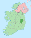
Villages and
Townlands- Allen
- Allenwood
- Ardclough
- Ballitore
- Ballymore Eustace
- Calverstown
- Caragh
- Carbury
- Castledermot
- Coill Dubh
- Celbridge
- Derrinturn
- Eadestown
- Hawkfield
- Johnstown
- Kilberry
- Kilcullen
- Kildangan
- Kilmead
- Kilmeague
- Kilteel
- Lullymore
- Milltown
- Moone
- Narraghmore
- Nurney
- Robertstown
- Straffan
- Staplestown
- Suncroft
- Timolin
Landforms Topics - Geography of County Kildare
- List of National Monuments in County Kildare
- List of townlands in County Kildare
- Mountains and hills of County Kildare
- Rivers of County Kildare
Counties of Ireland The counties are listed per provinceConnacht 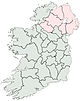
Munster Leinster Ulster Italics denote non-administrative counties. Brackets denote eponymous cities or non-traditional counties. † denotes counties of Northern IrelandCategories:- County Kildare
- Leinster
- Counties of the Republic of Ireland
- Local administrative units of the Republic of Ireland


Wikimedia Foundation. 2010.