- Brockton, Ontario
-
Brockton — Town — 
 Brockton
Coordinates: 44°10′N 81°13′W / 44.167°N 81.217°WCoordinates: 44°10′N 81°13′W / 44.167°N 81.217°W Country  Canada
Province  Ontario
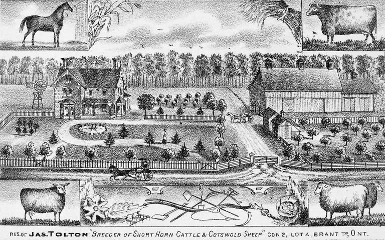
County Bruce Settled 1848 Formed January 1, 1999 Government – Mayor David Inglis – Federal riding Huron—Bruce – Prov. riding Huron—Bruce Area[1] – Land 565.07 km2 (218.2 sq mi) Population (2006)[1] – Total 9,641 – Density 17.1/km2 (44.3/sq mi) Time zone EST (UTC-5) – Summer (DST) EDT (UTC-4) Postal Code Area code(s) 519 and 226 Website www.brockton.ca  Residence of James Tolton, Brant Township, 1881
Brockton is a town in the Canadian province of Ontario, located in Bruce County. As of 2001[update], the population was 9,658. The area was 565.07 square kilometres.
The current municipality was formed on January 1, 1999, by amalgamating the former township of Brant, former township of Greenock and the town of Walkerton. Brockton's name was formed as a portmanteau of the three merged municipalities (Brant Greenock Walkerton).
Communities in the Municipality of Brockton include the former town of Walkerton and the villages within the boundaries of the two former Brant and Greenock Townships: Bradley, Cargill, Chepstow, Dunkeld, Eden Grove, Glammis, Greenock, Little Egypt, Malcolm, Maple Hill, Narva, Marle Lake, Lake Rosalind, Pearl Lake, Pinkerton, Portal, Riversdale and Solway.
Contents
Mayors
- David Thompson (1999-2003)
- Charlie Bagnato (2003-2010)
- David Inglis (2010-present)
Demographics
According to the Canada 2006 Census:[1]
- Population: 9,461
- Population change (2001-2006): -0.2
- Land area: 565.07 square kilometres (218.17 sq mi)
- Density (per km2.): 17.1
- Private dwellings occupied by usual residents: 3739 (total dwellings: 4064)
- Mother tongue:
- English as first language: 95.2 %
- French as first language: 0.2 %
- English and French as first language: 0 %
- Other as first language: 4.5 %
Population trend:[2]
- Population in 2006: 9641
- Population in 2001: 9658
- Population total in 1996: 10,163
- Brant (township): 3455
- Greenock (township): 1672
- Walkerton (town): 5036
- Population in 1991:
- Brant (township): 3420
- Greenock (township): 1741
- Walkerton (town): 4939
See also
- Bruce County municipal elections, 2010
References
- ^ a b c "Brockton community profile". 2006 Census data. Statistics Canada. http://www12.statcan.gc.ca/census-recensement/2006/dp-pd/prof/92-591/details/page.cfm?Lang=E&Geo1=CSD&Code1=3541032&Geo2=PR&Code2=35&Data=Count&SearchText=Brockton&SearchType=Begins&SearchPR=01&B1=All&Custom=. Retrieved 2011-01-26.
- ^ Statistics Canada: 1996, 2001, 2006 census
External links

Saugeen Shores Arran–Elderslie Chatsworth Kincardine 
West Grey
Hanover Brockton

Huron-Kinloss South Bruce Towns Townships First Nations Categories:- Towns in Ontario
- Municipalities in Bruce County, Ontario
- Western Ontario geography stubs

Wikimedia Foundation. 2010.