- Chisago County, Minnesota
-
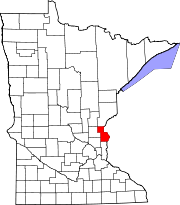
Chisago County, Minnesota 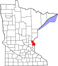
Location in the state of Minnesota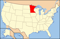
Minnesota's location in the U.S.Founded September 1, 1851 [1] Named for Chisago Lake Seat Center City Largest city North Branch Area
- Total
- Land
- Water
442.49 sq mi (1,146 km²)
417.63 sq mi (1,082 km²)
24.86 sq mi (64 km²), 5.62%Population
- (2010)
- Density
53,887
98/sq mi (38/km²)Time zone Central: UTC-6/-5 Website www.co.chisago.mn.us Chisago County (pronunciation: /ʃɨˈsɑːɡoʊ/ shə-sah-go) is a county located in the U.S. state of Minnesota. As of 2010, the population was 53,887.[1] Its county seat is Center City[2].
Contents
History
Chisago County is, like many other counties in Minnesota, strongly influenced by the Swedish immigrants that settled there in the middle of the 19th century. It was here Vilhelm Moberg made his research for his The Emigrants suite in the 1950s. A bronze statue of the author, holding his bicycle as if ready to ride away, stands on a stepped platform in Chisago City’s town park. His fictional characters Karl-Oskar and Kristina Nilsson from Ljuder parish in Småland settled around the Lake Ki-Chi-Saga (from the Ojibwe language Ki-chi-saga-igun (Gichi-zaaga'igan in the contemporary spelling) meaning "Big Lake-with-an-outlet," which was later shortened to Lake Chisago). The heritage of the early settlers is still honored by the annual Karl Oskar Days in Lindstrom.
Geography
According to the 2000 census, the county has a total area of 442.49 square miles (1,146.0 km2), of which 417.63 square miles (1,081.7 km2) (or 94.38%) is land and 24.86 square miles (64.4 km2) (or 5.62%) is water.[3]
Major highways
 Interstate 35
 U.S. Highway 8
 U.S. Highway 61
 Minnesota State Highway 95
Adjacent counties
- Pine County, Minnesota (north)
- Burnett County, Wisconsin (northeast)
- Polk County, Wisconsin (east)
- Washington County, Minnesota (south)
- Anoka County, Minnesota (southwest)
- Isanti County, Minnesota (west)
- Kanabec County, Minnesota (northwest)
National protected area
Demographics
Historical populations Census Pop. %± 1860 1,743 — 1870 4,358 150.0% 1880 7,982 83.2% 1890 10,359 29.8% 1900 13,248 27.9% 1910 13,537 2.2% 1920 14,445 6.7% 1930 13,189 −8.7% 1940 13,124 −0.5% 1950 12,669 −3.5% 1960 13,419 5.9% 1970 17,492 30.4% 1980 25,717 47.0% 1990 30,521 18.7% 2000 41,101 34.7% 2010 53,887 31.1% U.S. Decennial Census 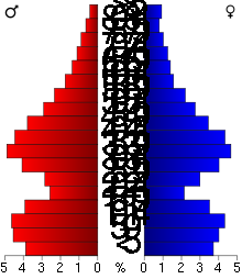 Age pyramid of county residents based on 2000 U.S. census data.
As of the census[4] of 2000, there were 41,101 people, 14,454 households, and 11,086 families residing in the county. The population density was 98 people per square mile (38/km²). There were 15,533 housing units at an average density of 37 per square mile (14/km²). The racial makeup of the county was 97.21% White, 0.51% Black or African American, 0.45% Native American, 0.70% Asian, 0.03% Pacific Islander, 0.31% from other races, and 0.80% from two or more races. 1.15% of the population were Hispanic or Latino of any race. 31.3% were of German, 18.1% Swedish, 11.3% Norwegian and 6.9% Irish ancestry according to Census 2000.
There were 14,454 households out of which 41.00% had children under the age of 18 living with them, 64.50% were married couples living together, 8.00% had a female householder with no husband present, and 23.30% were non-families. 18.40% of all households were made up of individuals and 7.40% had someone living alone who was 65 years of age or older. The average household size was 2.79 and the average family size was 3.18.
In the county the population was spread out with 30.20% under the age of 18, 7.10% from 18 to 24, 32.20% from 25 to 44, 20.70% from 45 to 64, and 9.80% who were 65 years of age or older. The median age was 34 years. For every 100 females there were 103.90 males. For every 100 females age 18 and over, there were 101.70 males.
The median income for a household in the county was $52,012, and the median income for a family was $57,335. Males had a median income of $40,743 versus $27,653 for females. The per capita income for the county was $21,013. About 3.20% of families and 5.10% of the population were below the poverty line, including 5.40% of those under age 18 and 8.00% of those age 65 or over.
Cities and towns
Cities Townships Unincorporated
Communities- Almelund
- Franconia
- Palmdale
- Rush Point
- Stark
- Sunrise
Schools
Climate and weather
Center City, Minnesota Climate chart (explanation) J F M A M J J A S O N D 0.92420.93171.643192.859333.770454.579564.484603.981583.672492.860371.942221.1278Average max. and min. temperatures in °F Precipitation totals in inches Source: The Weather Channel[5] Metric conversion J F M A M J J A S O N D 23-4-1723-1-14416-77215194217114261311229169927149022972163476-629-3-13Average max. and min. temperatures in °C Precipitation totals in mm In recent years, average temperatures in the county seat of Center City have ranged from a low of 2 °F (−17 °C) in January to a high of 84 °F (29 °C) in July, although a record low of −38 °F (−39 °C) was recorded in January 1977 and a record high of 104 °F (40 °C) was recorded in July 1988. Average monthly precipitation ranged from 0.89 inches (23 mm) in January to 4.48 inches (114 mm) in June.[5]
See also
References
- ^ "2010 Census Redistricting Data (Public Law 94-171) Summary File". American FactFinder. United States Census Bureau. http://factfinder2.census.gov/faces/tableservices/jsf/pages/productview.xhtml?pid=DEC_10_PL_GCTPL2.ST05&prodType=table. Retrieved 25 April 2011.
- ^ "Find a County". National Association of Counties. http://www.naco.org/Counties/Pages/FindACounty.aspx. Retrieved 2011-06-07.
- ^ "Census 2000 U.S. Gazetteer Files: Counties". United States Census. http://www.census.gov/tiger/tms/gazetteer/county2k.txt. Retrieved 2011-02-13.
- ^ "American FactFinder". United States Census Bureau. http://factfinder.census.gov. Retrieved 2008-01-31.
- ^ a b "Monthly Averages for Center City, Minnesota". The Weather Channel. http://www.weather.com/weather/wxclimatology/monthly/graph/USMN0131. Retrieved 2011-11-06.
External links
- Chisago County government's website
- Chisago County Historical Society website
- Minnesota DOT Highway map of Chisago County

Kanabec County Pine County Burnett County, Wisconsin Isanti County 
Polk County, Wisconsin  Chisago County, Minnesota

Anoka County Washington County Municipalities and communities of Chisago County, Minnesota Cities Center City | Chisago City | Harris | Lindstrom | North Branch | Rush City | Shafer | Stacy | Taylors Falls | Wyoming
Townships Unincorporated
communityCategories:- Minnesota counties
- Chisago County, Minnesota
- Minneapolis–Saint Paul


Wikimedia Foundation. 2010.