- High Rock Lake Wilderness
Geobox|protected area
name = High Rock Lake
native_name =
other_name =
category = Wilderness
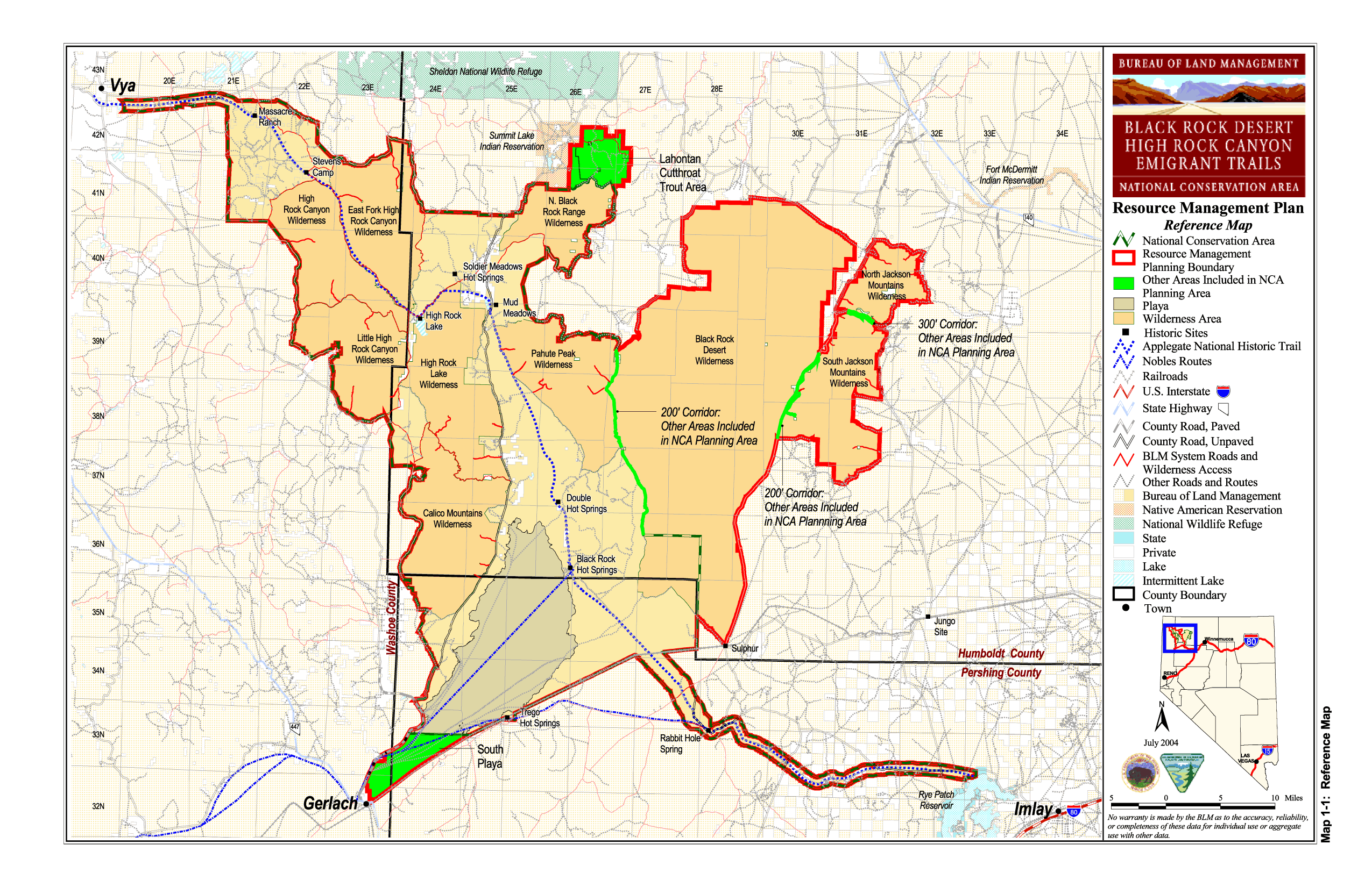
image_caption = BLM map of the Black Rock-High Rock NCA and 10 wilderness areas including High Rock Lake Wilderness
official_name =
etymology =
motto =
nickname =
symbol =
country = United States
state = Nevada
region = Black Rock Desert
district =
municipality =
topo_
topo_maker =USGS
parent =
range =
border =
part =
tributary_left =
tributary_right =
child_left =
child_right =
city =
landmark =
building =
river =
location = Humboldt County
elevation = 1852
prominence =
lat_d = 41 | lat_m = 12 | lat_s = 53.629 | lat_NS = N
long_d = 119 | long_m = 13 | long_s = 19.665 | long_EW = W
highest_location = | highest_region = | highest_state =
highest_elevation_imperial =
highest_lat_d = | highest_lat_m = | highest_lat_s = | highest_lat_NS =
highest_long_d = | highest_long_m = | highest_long_s = | highest_long_EW =
lowest =
lowest_location = | lowest_region = | lowest_country =
lowest_elevation_imperial =
lowest_lat_d = | lowest_lat_m = | lowest_lat_s = | lowest_lat_NS =
lowest_long_d = | lowest_long_m = | lowest_long_s = | lowest_long_EW =
source =
source_location = | source_region = | source_country =
source_elevation_imperial =
source_lat_d = | source_lat_m = | source_lat_s = | source_lat_NS =
source_long_d = | source_long_m = | source_long_s = | source_long_EW =
source1 =
source1_location = | source1_region = | source1_country =
source1_elevation_imperial =
source1_lat_d = | source1_lat_m = | source1_lat_s = | source1_lat_NS =
source1_long_d = | source1_long_m = | source1_long_s = | source1_long_EW =
source_confluence =
source_confluence_location = | source_confluence_region = | source_confluence_state =
source_confluence_elevation_imperial =
source_confluence_lat_d = | source_confluence_lat_m = | source_confluence_lat_s = | source_confluence_lat_NS =
source_confluence_long_d = | source_confluence_long_m = | source_confluence_long_s = | source_confluence_long_EW =
mouth =
mouth_location = | mouth_region = | mouth_country =
mouth_elevation_imperial =
mouth_lat_d = | mouth_lat_m = | mouth_lat_s = | mouth_lat_NS =
mouth_long_d = | mouth_long_m = | mouth_long_s = | mouth_long_EW =
length_imperial = | length_orientation =
width_imperial = | width_orientation =
height_imperial =
depth_imperial =
volume_imperial =
weight_imperial =
area_imperial =
area_unit = acre
area_land_imperial =
area_water_imperial =
area_urban_imperial =
area_metro_imperial =
discharge_imperial =
discharge_max_imperial =
discharge_min_imperial =
geology =
orogeny =
period =
biome =
plant =
animal =
author =
style =
material =
established = 2000
date = December 21
management = Bureau of Land Management
management_location = | management_region = | management_country =
management_elevation_imperial =
management_lat_d = | management_lat_m = | management_lat_s = | management_lat_NS =
management_long_d = | management_long_m = | management_long_s = | management_long_EW =
government =
government_location = | government_region = | government_country =
government_elevation_imperial =
government_lat_d = | government_lat_m = | government_lat_s = | government_lat_NS =
government_long_d = | government_long_m = | government_long_s = | government_long_EW =
owner =
mayor =
leader =
public = Open to the public. BLM wilderness rules apply - mechanized travel prohibited.
visitation = | visitation_date =
access =
ascent = | ascent_date =
discovery = | discovery_date =
timezone = Pacific | utc_offset = -8
timezone_DST = PDT | utc_offset_DST = -7
postal_code =
area_code =
code =
whs_name =
whs_year =
whs_number =
whs_region =
whs_criteria =
iucn_category = Ib
free = | free_type =

map_caption = location of High Rock Lake Wilderness inNevada cite gnis|2035155|High Rock Lake Wilderness]
map_background =
map_locator = Nevada
commons =
statistics =
website =
footnotes =The High Rock Lake Wilderness is a wilderness area inNevada containing the northern portion of theCalico Mountains . High Rock Lake, for which the wilderness was named, was created about 11,800 years ago after a largerockslide closed the outlet (Box Canyon) to High Rock and Little High Rock Canyons. This new outlet (Fly Canyon) cut a narrow canyon that empties at Soldier Meadows. One special geological feature in Fly Canyon is the potholes. The potholes were carved bywhirlpool action of sand and gravel in the stream. Another unique feature is the Fly Slide where emigrants lowered their wagons with ropes into Fly Canyon portion of theApplegate-Lassen Trail . Elevations in the wilderness range from 4,000 to 7,660 feet with scattered vegetation ofsaltbrush andsage .The wilderness area is managed by the
Bureau of Land Management .. [cite web
title = BLM Black Rock Desert-High Rock Canyon Emigrant Trails National Conservation Area
publisher =Bureau of Land Management
url = http://www.nv.blm.gov/Winnemucca/blackrock/BRHR_background.htm
accessdate = 2007-12-30 ]See also
*
Black Rock Desert-High Rock Canyon Emigrant Trails National Conservation Area References
External links
* [http://www.wilderness.net/index.cfm?fuse=NWPS&sec=wildView&WID=245 High Rock Lake Wilderness page at Wilderness.net]

Wikimedia Foundation. 2010.