- 1970 North Indian Ocean cyclone season
Infobox hurricane season
Track=1970 North Indian Ocean cyclone season summary.jpg
Basin=NIO
Year=1970
First storm formed=May 2 ,1970
Last storm dissipated=November 29 ,1970
Strongest storm name=Bhola Cyclone
Strongest storm winds=100
Strongest storm pressure=966
Total depressions=15
Total storms=
Total hurricanes=7
Fatalities=300,000-500,000
Da
five seasons=Pre-1980 North Indian Ocean cyclone seasons The 1970 North Indian Ocean cyclone season had no bounds, buttropical cyclone s in the NorthIndian Ocean tend to form between April and December, with peaks in May and November. The 1970 season saw a total of seven cyclonic storms, of which three developed into severe cyclonic storms. TheBay of Bengal was more active than theArabian Sea during 1970, with all of the three severe cyclonic storms in the season forming there. Unusually, none of the storms in the Arabian Sea made landfall this year. The most significant storm of the season was the Bhola cyclone, which formed in the Bay of Bengal and hitBangladesh onNovember 12 . The storm killed over 500,000 people, making it the deadliest tropical cyclone in recorded history. __TOC__torms
evere Cyclonic Storm One
Infobox Hurricane Small
Basin=NIO
Type=svrcyclstorm
Formed=May 2
Dissipated=May 7
3-min winds=80
Pressure=975A low pressure area that developed over the southernAndaman Sea late in April moved north into theBay of Bengal becoming the first depression of the year onMay 2 . The depression intensified under the influence of a high-level anticyclone and became a cyclonic storm the next day. The storm then turned to the northeast and strengthened into a severe cyclonic storm onMay 4 . Soon after this, it peaked with winds of 150 km/h (90 mph) and a well-defined eye formed. The storm made its landfall nearCox's Bazar in easternmostEast Pakistan (nowBangladesh ) early in the morning ofMay 7 and dissipated over westernBurma that evening.The cyclone brought widespread rain to the Andaman and
Nicobar Islands before it moved clear of them onMay 3 . Effects in East Pakistan are unknown, butAkyab in western Burma reported winds of 55 km/h (35 mph) as the cyclone approached land.cite web|url=http://docs.lib.noaa.gov/rescue/cd024_pdf/005ED281.pdf#page=4|title=Annual Summary - Storms & Depressions|work=India Weather Review 1970|author=India Meteorological Department |year=1970|accessdate=2007-04-15|format=PDF|pages=p. 4]Depression Two
Infobox Hurricane Small
Basin=NIO
Formed=May 23
Dissipated=May 24
Prewinds=≥
3-min winds=17A depression formed in the northeast of the Bay of Bengal on during the morning ofMay 23 near theEast Pakistan coast. It moved towards the coast and made landfall to the south ofCox's Bazar that night, before dissipating over southernAssam the next day. Any effects on land are unknown.Cyclonic Storm Three
Infobox Hurricane Small
Basin=NIO
Type=cyclstorm
Formed=May 28
Dissipated=June 2
3-min winds=50
Pressure=986A low pressure area developed off theKarnataka -Goa coastline in theArabian Sea onMay 27 and developed into a depression the next day. The system developed further into a cyclonic storm onMay 29 as it moved to the north. The storm reached its peak with 95 km/h (60 mph) soon after this as it turned to the west, but soon degenerated into a deep depression over the northern Arabian Sea onMay 31 . The depression continued to move west, weakening to a remnant low shortly as it made landfall on theArabian Peninsula onJune 2 . The remnant low dissipated over southernSaudi Arabia the next day.cite web|url=http://docs.lib.noaa.gov/rescue/cd024_pdf/005ED281.pdf#page=12|title=Annual Summary - Storms & Depressions|work=India Weather Review 1970|author=India Meteorological Department |year=1970|accessdate=2007-04-15|format=PDF|pages=p. 12]The cyclone itself had minimal effects on land, but the monsoon advanced into western India in late May in association with the system. As the cyclone moved to the west away from the subcontinent, the incursion of moist air from the Arabian Sea persisted over northwestern India for the first three days of June. This brought moderate rainfall to regions of
Gujarat ,Rajasthan and westernMadhya Pradesh .Cyclonic Storm Four
Infobox Hurricane Small
Basin=NIO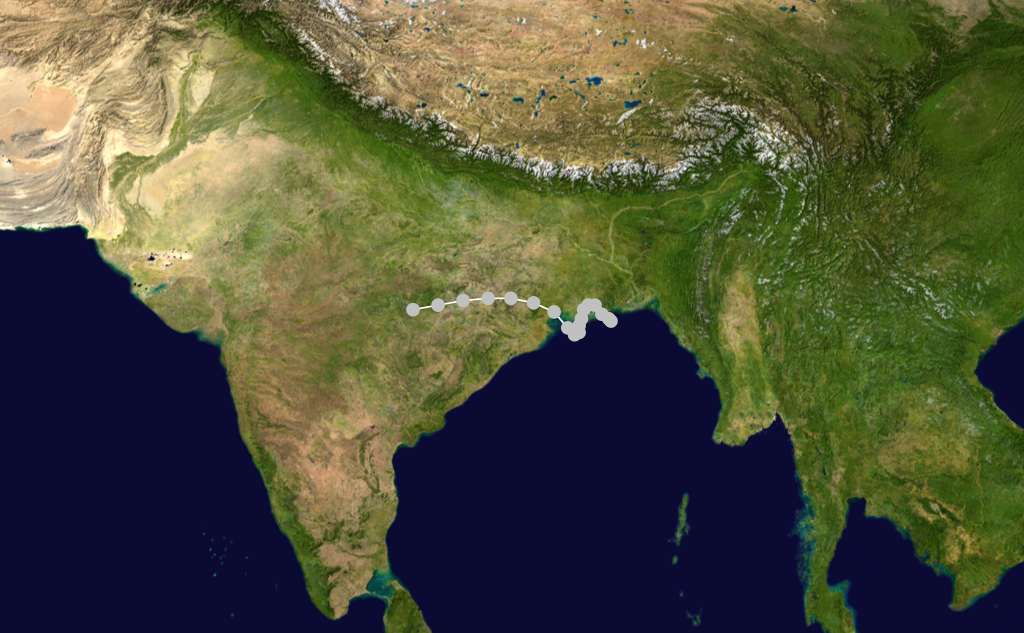
Formed=June 7
Dissipated=June 11
Prewinds=≥
3-min winds=35
Pressure=986A low pressure area developed in the northern Bay of Bengal onJune 6 and developed into a depression the next day as it drifted to the north, moving over south of theGanges Delta . The depression reversed its course overland, reemerging into the Bay of Bengal onJune 8 . Once over water, the depression intensified into a cyclonic storm on the morning ofJune 9 . The cyclone's motion shifted to the northwest and it made a second landfall nearBalasore in northernOrissa that night. The cyclone quickly weakened to a deep depression overland and tracked to the west over central India, where it degenerated into a broad area of low pressure onJune 11 .cite web|url=http://docs.lib.noaa.gov/rescue/cd024_pdf/005ED281.pdf#page=4|title=Annual Summary - Storms & Depressions|work=India Weather Review 1970|author=India Meteorological Department |year=1970|accessdate=2007-04-15|format=PDF|pages=pp. 4-5]Sustained winds of 65 km/h (40 mph) were recorded at Sandheads on
June 9 , while the cyclone was at its peak offshore. High levels of rain affected much of Orissa andWest Bengal , with over 100 mm (4 inches) falling over large areas of both states. As the storm dissipated overland, it brought severe rain toVidarbha and southernMadhya Pradesh . The highest recorded rainfall was atKhandwa were 280 mm (11 inches) fell onJune 13 alone. The rains led to localised flooding in parts of Vidarbha and disrupted road transport in the region.Deep Depression Five
Infobox Hurricane Small
Basin=NIO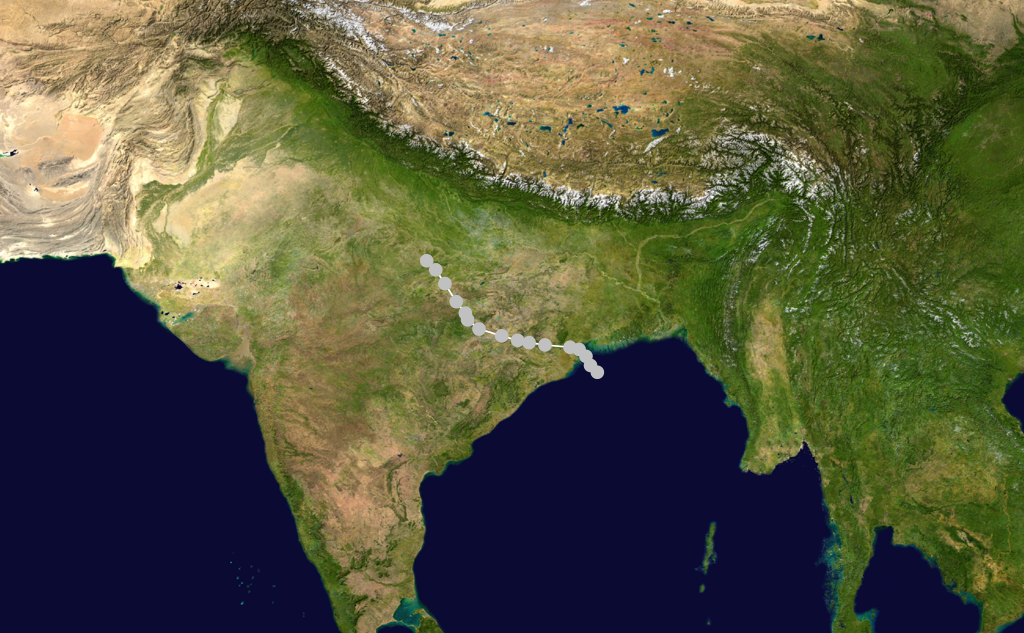
Formed=June 29
Dissipated=July 3
Prewinds=≥
3-min winds=28A low pressure area that had developed over the northernBay of Bengal the previous day concentrated into a depression early onJune 29 . The depression intensified as it moved to the northwest, becoming a deep depression shortly before it crossed theOrissa coast. After landfall the storm continued to move to the northwest, weakening to a depression again onJuly 2 over northeastMadhya Pradesh . It degenerated into a remnant low over centralUttar Pradesh during the evening onJuly 3 .cite web|url=http://docs.lib.noaa.gov/rescue/cd024_pdf/005ED281.pdf#page=5|title=Annual Summary - Storms & Depressions|work=India Weather Review 1970|author=India Meteorological Department |year=1970|accessdate=2007-04-15|format=PDF|pages=p. 5]The depression brought intense monsoon conditions to Orissa, Madhya Pradesh and
Vidarbha during its life. Over 210 mm (8 inches) of rain and winds of 85 km/h (50 mph) were recorded inParadip as the depression made landfall onJune 30 . Inland, the heavy rains caused some rivers in Orissa to overflow and flooded rice paddies inCuttack District . Further west, theWainganga River overflowed its banks in places. Road transport in Madhya Pradesh was disrupted and there was damage to crops in theRaipur area. Raipur recorded the highest 24-hour rains associated with the depression, with 230 mm (9 inches) falling there onJuly 2 .Deep Depression Six
Infobox Hurricane Small
Basin=NIO
Formed=July 6
Dissipated=July 8
Prewinds=≥
3-min winds=28
Prepressure=≤
Pressure=992A low pressure area moved to the west off the Burmese coast onJuly 5 and developed into a depression the next day in the north centralBay of Bengal . The depression intensified as it moved to the northwest, becoming a deep depression onJuly 7 . The system made landfall on theOrissa coast during the morning ofJuly 8 and rapidly degenerated into a broad area of low pressure overland. The remnant low moved north over westernBihar and it persisted there untilJuly 12 when it was absorbed by themonsoon trough .cite web|url=http://docs.lib.noaa.gov/rescue/cd024_pdf/005ED281.pdf#page=5|title=Annual Summary - Storms & Depressions|work=India Weather Review 1970|author=India Meteorological Department |year=1970|accessdate=2007-04-15|format=PDF|pages=pp. 5-6]Winds of 55 km/h (30 mph) were recorded offshore at Sandheads when the system was at its peak. The depression brought isolated heavy rains to many places throughout
East India , with rains in excess of 100 mm (4 inches) falling every day from the depression's landfall until the absorption of the remnant low.Depression Seven
Infobox Hurricane Small
Basin=NIO
Formed=August 17
Dissipated=August 19
Prewinds=≥
3-min winds=17A low pressure area that lay overBurma onAugust 15 , moved to the west across theBay of Bengal and developed into a depression on the evening ofAugust 17 when it was 100 km (65 miles) southeast ofGopalpur-on-Sea . The depression moved to the northwest and made landfall near Gopalpur-on-Sea and turned to the west overland. The depression had weakened into a remnant low byAugust 20 , when it was over westernMadhya Pradesh .cite web|url=http://docs.lib.noaa.gov/rescue/cd024_pdf/005ED281.pdf#page=6|title=Annual Summary - Storms & Depressions|work=India Weather Review 1970|author=India Meteorological Department |year=1970|accessdate=2007-04-15|format=PDF|pages=p. 6]The depression and associated weather brought widespread rain to much of south and central India, with heavy rain falling in some locations. The heavy rain in
Maharashtra disrupted road transport in many areas, especially in the east of the state. TheGodavari River inundated parts ofBhadrachalam and many villages in regions ofAndhra Pradesh . The rains also damaged rice paddies and disrupted transport inTelangana . Rains associated with the depression reached as far west asBombay with 200 mm (8 inches) falling there onAugust 19 .Cyclonic Storm Eight
Infobox Hurricane Small
Basin=NIO
Formed=September 2
Dissipated=September 13
Prewinds=≥
3-min winds=34A low pressure area that was centred overWest Bengal onAugust 31 concentrated into a depression onSeptember 2 when it was 50 km (30 miles) to the east ofMidnapore . It intensified as it moved to the west, becoming a deep depression the next day, about 50 km (30 miles) east ofRanchi . The system continued move west across India, before weakening into a depression onSeptember 7 nearAhmedabad ,Gujarat . The depression then turned north and entered southwestRajasthan .cite web|url=http://docs.lib.noaa.gov/rescue/cd024_pdf/005ED281.pdf#page=7|title=Annual Summary - Storms & Depressions|work=India Weather Review 1970|author=India Meteorological Department |year=1970|accessdate=2007-04-15|format=PDF|pages=p. 7] OnSeptember 8 , the system turned to the southwest and emerged into theArabian Sea the following evening. Over water it intensified again, becoming a cyclonic storm by the evening ofSeptember 10 . The cyclone developed a short-lived eye onSeptember 11 as it drifted slowly to the west, before degenerating into a broad area of low pressure as it neared theOman coast onSeptember 14 .This system brought widespread rains to a wide swathe of India during its existence. Some heavy rains in West Bengal flooded vast areas of many districts and resulted in some fatalities, whilst in parts of neighbouring
Orissa the floodwaters damaged fields. 390 mm (15 inches) of rain fell onBardhaman over two days as the depression passed overhead. Several thousand people were made homeless in West Bengal. Both the Narmada andTapti River s inundated parts ofMadhya Pradesh and Gujarat. The floods in Gujarat took many lives and caused severe damage to crops and other properties. Between 300 and 400 people were washed away in two villages inBharuch district . 260 mm (10 inches) of rain fell onSurat onJuly 7 and a further 80 mm (3 inches) onKutch District as the cyclone moved out to sea.Deep Depression Nine
Infobox Hurricane Small
Basin=NIO
Formed=September 8
Dissipated=September 18
Prewinds=≥
3-min winds=28
Pressure=990A low pressure area moved fromBurma to theBay of Bengal onSeptember 8 where it developed into a depression. The depression strengthened as it moved to the northwest and became a deep depression the next day, when it was 150 km (130 miles) southeast ofCalcutta . The system crossed theWest Bengal coast later and moved to the northwest across theChota Nagpur Plateau . The depression stalled overUttar Pradesh onSeptember 12 and remained nearLucknow untilSeptember 14 . The depression then turned to the east and weakened to a remnant low over northernBihar onSeptember 18 .cite web|url=http://docs.lib.noaa.gov/rescue/cd024_pdf/005ED281.pdf#page=7|title=Annual Summary - Storms & Depressions|work=India Weather Review 1970|author=India Meteorological Department |year=1970|accessdate=2007-04-15|format=PDF|pages=pp. 7-8]The depression brought widespread rain to West Bengal,
Orissa , Bihar, Uttar Pradesh andMadhya Pradesh during its lifespan, with rains of 140 mm (5.5 inches) as far west as Lucknow. The rains in Uttar Pradesh caused severe property damage and flooding, with some 150 people losing their lives in the state. TheGanges flooded in northern Bihar, inundating parts ofMunger District , whilst theGandaki River flooded parts ofMotihari . The rains worsened floods in south Bengal, increasing the death toll from the floods there to 80 and affecting 8 million people, with considerable damage done to crops and housing.Jaleswar in Orissa was entirely flooded.Depression Ten
Infobox Hurricane Small
Basin=NIO
Formed=September 21
Dissipated=September 23
Prewinds=≥
3-min winds=17A well-defined low pressure area formed over the west centralBay of Bengal onSeptember 20 and developed into a depression the next morning about 100 km (60 miles) south-east ofVisakhapatnam . The depression then moved overland and after crossingVidarbha weakened into a remnant low overGujarat onSeptember 23 .cite web|url=http://docs.lib.noaa.gov/rescue/cd024_pdf/005ED281.pdf#page=8|title=Annual Summary - Storms & Depressions|work=India Weather Review 1970|author=India Meteorological Department |year=1970|accessdate=2007-04-15|format=PDF|pages=pp. 8-9]The depression brought widespread rain to northern
South India as it passed over the country and its remnants brought scattered rain to Gujarat over the following week. Over a period of four hours, heavy rain fell on Hyderabad andSecunderabad , destroying many houses in the two cities. About 130 mm (5 inches) of rain fell onBombay as the system dissipated. The heavy rains claimed about 75 lives.Depression Eleven
Infobox Hurricane Small
Basin=NIO
Formed=October 11
Dissipated=October 13
Prewinds=≥
3-min winds=17A low pressure area that developed in the Bay of Bengal passed over the southernIndian subcontinent and developed into a depression in the Arabian Sea off the southernMaharashtra coast onOctober 11 . The depression did not develop as it drifted west, and it degenerated into an area of low pressure as it was approaching theArabian Peninsula . The depression brought widespread rains to southern Maharashtra andKarnataka states, with 40 mm (1.5 in) of rain recorded inKarwar . Scattered heavy rain was also reported in theLaccadives .cite web|url=http://docs.lib.noaa.gov/rescue/cd024_pdf/005ED281.pdf#page=12|title=Annual Summary - Storms & Depressions|work=India Weather Review 1970|author=India Meteorological Department |year=1970|accessdate=2007-04-15|format=PDF|pages=pp. 12-13]evere Cyclonic Storm Twelve
Infobox Hurricane Small
Basin=NIO
Type=svrcyclstorm
Formed=October 18
Dissipated=October 24
3-min winds=70
Pressure=980A depression formed onOctober 18 in the centralBay of Bengal and moved to the north. It gradually intensified and turned to the northeast, becoming a cyclonic storm onOctober 20 . The storm became the second severe cyclonic storm of the season the following day, and turned onto a more northerly track towards theGanges Delta . The storm peaked with winds of 130 km/h (80 mph) before it made landfall near theWest Bengal -East Pakistan border during the morning ofOctober 23 . The storm then crossed over East Pakistan, before dissipating over southernAssam onOctober 24 .cite web|url=http://docs.lib.noaa.gov/rescue/cd024_pdf/005ED281.pdf#page=9|title=Annual Summary - Storms & Depressions|work=India Weather Review 1970|author=India Meteorological Department |year=1970|accessdate=2007-04-15|format=PDF|pages=pp. 9-10]This cyclone brought widespread rain to
Tamil Nadu as it formed and to theAndaman and Nicobar Islands as it moved over the Bay of Bengal. After its landfall it brought severe rains to West Bengal, Assam and East Pakistan. The highest recorded rainfall in India was atShillong where 220 mm (8.6 inches) fell onOctober 24 . A gust of 105 km/h (65 mph) was recorded inCalcutta as the storm passed by to the east, where it caused the failure of the power supply.The cyclone claimed between 200 and 300 lives in East Pakistan, with the worst of the damage occurring in
Khulna District . Over 200 villages were destroyed in the district leaving several thousand people homeless, and there was extensive damage to crops.cite news|author=Staff writer|publisher=Reuters |title=125 Die In Hurricane In Pakistan|url=http://thehurricanearchive.com/cache/21132106.pdf|format=PDF|date=1970-10-27 |accessdate=2007-04-15|work=Daily Gleaner]evere Cyclonic Storm Thirteen
Infobox Hurricane Small
Basin=NIO
Type=svrcyclstorm
Formed=November 8
Dissipated=November 13
3-min winds=100
Pressure=960On the morning ofNovember 8 a depression formed in the south-central Bay of Bengal. It moved very slowly to the north, becoming a cyclonic storm the next day. It continued to intensify as it approached the head of the Bay, becoming the third severe cyclonic storm of the season onNovember 11 . That evening it reached its peak with winds of 185 km/h (115 mph) with a well-developed eye and became the strongest storm of the season. It then made landfall on the coast ofEast Pakistan during the night ofNovember 12 . The cyclone weakened rapidly as it moved inland and dissipated the next day over southAssam .cite web|url=http://docs.lib.noaa.gov/rescue/cd024_pdf/005ED281.pdf#page=10|title=Annual Summary - Storms & Depressions|work=India Weather Review 1970|author=India Meteorological Department |year=1970|accessdate=2007-04-15|format=PDF|pages=pp. 10-11]This cyclone brought a devastating
storm surge of up to 10 metres (33 ft) high to theGanges Delta . Largely as a result of this surge somewhere between 300,000 and 500,000 people lost their lives, making this storm the deadliesttropical cyclone ever recorded and one of the deadliestnatural disaster s of modern times.cite web|url=http://www.iwmbd.org/html/PUBS/publications/P024.PDF|title=Cyclonic Storm Surge Modelling for Design of Coastal Polder|author=Kabir, M. M.|coauthors=Saha B. C.; Hye, J. M. A.|accessdate=2007-04-15|format=PDF|publisher=Institute of Water Modelling ] The total damage from the storm exceeded $85 million (1970USD , $480 million 2008 USD) and much of the agricultural and fishing capacity of the region was wiped out. In total some 3.6 million people suffered direct effects from this cyclone.cite web|author=EM-DAT: the International Disaster Database|year=2007|title=Disaster List for Bangladesh|publisher=Centre for Research on the Epidemiology of Disasters|accessdate=2007-04-15|url=http://www.em-dat.net/index.htm]The
Pakistan i government was severely criticised for its handling of the relief operations following the storm, both by local political leaders in East Pakistan and in the international media. In the December national elections, the oppositionAwami League gained alandslide victory , gaining 160 of the 162 East Pakistani seats. Continuing unrest between East Pakistanis and the central government trigged theBangladesh Liberation War , which concluded with the creation of the state ofBangladesh . This is one of the first times that a natural event helped to trigger a civil war.cite web|url=http://www.usaid.gov/our_work/humanitarian_assistance/disaster_assistance/publications/ofda_cjanalysis_02_21-2005.pdf|accessdate=2007-04-15|format=PDF|date=2005-02-21 |title=A Critical Juncture Analysis, 1964-2003|last=Olson|first=Richard|publisher=USAID ]Deep Depression Fourteen
Infobox Hurricane Small
Basin=NIO
Formed=November 19
Dissipated=November 20
Prewinds=≥
3-min winds=28A low pressure that had developed over the southAndaman Sea moved west across the southernBay of Bengal and concentrated into a depression on the morning ofNovember 19 , when it was about 600 km (400 miles) southeast ofMadras . The system intensified further into a deep depression as it moved west-northwest and hit theTamil Nadu the following day. The depression weakened into a remnant low over Tamil Nadu.cite web|url=http://docs.lib.noaa.gov/rescue/cd024_pdf/005ED281.pdf#page=11|title=Annual Summary - Storms & Depressions|work=India Weather Review 1970|author=India Meteorological Department |year=1970|accessdate=2007-04-15|format=PDF|pages=p. 11]The depression brought widespread rain to much of Tamil Nadu, with heavy rain hitting the coastal regions. Low-lying coastal regions from
Pondicherry to Atirampattinam. There was damage to crops and housing inThanjavur District and the rains left thousands homeless in Madras.Cuddalore experienced exceptionally heavy rains with over 440 mm (17 inches) falling there, of which 310 mm (12 inches) fell onNovember 20 alone.Cyclonic Storm Fifteen
Infobox Hurricane Small
Basin=NIO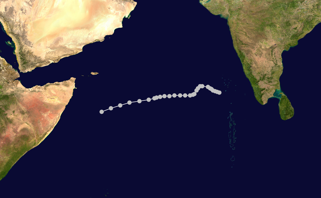
Formed=November 22
Dissipated=November 29
3-min winds=40The remnant low of a depression emerged into theArabian Sea offKerala late onNovember 21 and developed into a new depression the next day as it moved west. The depression moved further west, and gradually turned toward the southwest, intensifying as it did so. It became a cyclonic storm onNovember 28 to the southeast ofSocotra and reached its peak with 75 km/h (25 mph) winds soon after. The cyclone continued to move west-southwestwards and rapidly weakened into a remnant low pressure area off theSomalia coast the next day, ending the season.cite web|url=http://docs.lib.noaa.gov/rescue/cd024_pdf/005ED281.pdf#page=14|title=Annual Summary - Storms & Depressions|work=India Weather Review 1970|author=India Meteorological Department |year=1970|accessdate=2007-04-15|format=PDF|pages=p. 14]The cyclone brought widespread rain to the
Laccadives fromNovember 22 toNovember 24 , with 60 mm (2.4 inches) recorded on Amini onNovember 23 .ee also
*
List of North Indian Ocean cyclone seasons
*List of notable tropical cyclones
*1970 Atlantic hurricane season
*1970 Pacific hurricane season
*1970 Pacific typhoon season
*Southern Hemisphere tropical cyclone seasons: 1969–70, 1970–71References

Wikimedia Foundation. 2010.