- Dehradun
-
This article is about the municipality in Uttarakhand, India. For its namesake district, see Dehradun district.
Dehradun
Dronagiri
— capital — Forest Research Institute
Coordinates 30°18′57″N 78°02′01″E / 30.3157°N 78.0336°ECoordinates: 30°18′57″N 78°02′01″E / 30.3157°N 78.0336°E Country India State Uttarakhand District(s) Dehradun Population 1,025,680 (2011[update]) Time zone IST (UTC+05:30) Area
• 450 metres (1,480 ft)
Footnotes- The Doon City.
Website http://dehradun.nic.in/ Dehradun (Garhwali/Hindi: देहरादून, Dēharādūn) is the capital city of the State of Uttarakhand in north India. Located in the Garhwal region, it is 255 km north of India's capital New Delhi and consists of 6 tehsils, 6 community development blocks, 17 towns and 764 inhabited villages.[1] The city has been chosen as one of the "Counter Magnets" of the National Capital Region (NCR) and is being developed as an alternative centre of growth to help ease the migration and population explosion in the Delhi metropolitan area.[2]
Dehradun is renowned for its natural resources, publishing services, and for its prestigious educational institutions such as the Forest Research Institute, Indian Military Academy and several day and boarding schools which are highly reputed across the country. It is also home to national foundations such as the Indian Institute of Petroleum, Survey of India, Wildlife Institute of India and the Oil and Natural Gas Corporation.[3]
Located on the foothills of the Himalayas, the Doon Valley is nestled between two of India's mightiest rivers - the Ganges on the east and the Yamuna on the west. Dehradun is famous for its picturesque landscape and pleasant climate and provides a gateway to the surrounding region. It is well connected and in close proximity to popular Himalayan tourist destinations such as Mussoorie, Nainital and Auli and Hindu holy cities of Haridwar and Rishikesh along with the Himalayan pilgrimage circuit of Char Dham.
Contents
Etymology
Dehradun is made up of two words Dehra and doon, where 'Dehra' derived from the word "dera" meaning camp whereas "doon" is term for the valley that lies between the Himalayas and the "Shivaliks". When Ram Rai , son of Guru Har Rai, came to this region along with his followers, he established a camp here for their stay. It was around this time that the modern city of Dehradun started to develop. This is when the word Dehra was linked to doon , and thus the city was named Dehradun.[4] Some historians also believe that the word Dehra cannot be regarded as a term for camping. This term is still used in Punjabi and Hindi.[5]
History
Main article: History of DehradunThe history of the capital of Uttarakhand, Dehradun (sometimes written as Dehra Doon, nicknamed "Doon Valley") is linked to the story of Ramayana and Mahabharata. It is believed that after the battle between Ravan and Lord Ram, Lord Ram and his brother Laxman visited this site. Dronacharya, the legendary royal guru to the Kauravas and Pandavas in the epic Mahabharata is also believed to have been born and resided in Dehradun.[6] Evidence such as ancient temples and idols have been found in the areas surrounding Dehradun which have been linked to the mythology of Ramayana and Mahabharata. These relics and ruins are believed to be around 2000 years old. Furthermore, the location, the local traditions and the literature reflect this region's links with the events of Mahabharata and Ramayana. Even after the battle of Mahabharata, the Pandavas had influence on this region as the rulers of Hastinapur along with the descendants of Subahu ruled the region as subsidiaries. Likewise, Rishikesh is also mentioned in the pages of history when Lord Vishnu answered the prayers of the saints, slaughtered the demons and handed the land to the saints.
In the seventh century this area was known as Sudhnagar and was described by the Chinese traveler Huen Chang. It was Sudhnagar that later came to be recognised as the name of Kaalsi. Edicts of Ashoka have been found in the region along the banks of river Yamuna in Kaalsi indicating the wealth and importance of the region in ancient India. In the neighbouring region of Haripur, ruins were discovered from the time of King Rasala which also reflect the region's prosperity.
Dehradun was invaded by Mahmud of Ghazni during his campaigns into India followed by Taimooralang in 1368, Ruahela Njibuddulo in 1757 and Ghulam Qadir in 1785. In 1806 Nepali King Prithvi Narayan Shah united Nepal and many of the Indian territories now fell under Nepal such as Almora,Phatankot,Kumaon Garhwal,Simur,Shimla, Kangra and Dehradun itself. But when the British East India company and Nepal went on war with each other from 1814 to 1816 and as a "deal" all these parts of Nepal were given to British East India company. The deal or so called treaty between the two countries was called Sugauli Treaty. The British conquered Dehardun in 1816 and colonised Landour and Mussoorie in 1827-1828. In the 1970s it was involved in the Garhwal Mandal. In 2000 , Uttarakhand (earlier called Uttaranchal) state was created from the north-western districts of the Indian state of Uttar Pradesh and Dehradun made its provisional capital. After becoming the capital of the city there has been continuous development.[7]
Dehradun Climate chart (explanation) J F M A M J J A S O N D 471955522952261321321754352023034226313022627302226130203228131124103216Average max. and min. temperatures in °C Precipitation totals in mm Source: Climate of Dehradun District Imperial conversion J F M A M J J A S O N D 1.966412.27248279550.890632.195689.193722586722586721086681.382550.475500.17043Average max. and min. temperatures in °F Precipitation totals in inches Geography
The Dehradun district has various types of physical geography from Himalayan mountains to Plains. Raiwala is the lowest point at 315 meters above sea level, and the highest points are within the Tiuni hills, rising to 3700 m above sea level. The Doon valley contains the settlements including Dehradun, Doiwala, Herbertpur, Vikasnagar, Sahaspur, Rishikesh, Raiwala and Clement Town.
There district contains Rajaji National Park which is home to several elephants. The Doon valley has the Terai and Bhabar forests within it as well as the Shiwalik hills and Lesser Himalayan Range containing hill stations such as Mussoorie and Chakrata. The district is bordered by the Himalayas in the north, the Sivalik Hills to the south, the river Ganges to the east, and the Yamuna river to the west. Towns located in the foothills of the mountain ranges include Mussoorie,Sahastradhara, Chakrata, Lahkhamondal and Dakpathar.
This district is divided into two major parts, the main city Dehradun surrounded by Shivalik and the Himalayas, and Jaunsar Bavar, which is located in the foothills of Himalayas. In the north and northwest it borders on the district of Uttarkashi and in the east by Tehri and Pauri. In the west, it is bordered by Sirmaur district of Himachal Pradesh and the Tons and Yamuna rivers. To the south are Haridwar and Uttar Pradesh's Saharanpur district.
It is located between latitudes 29 °58' N and 31°2'N and longitudes 77° 34' E and 78° 18'E.[8] This district consists of 6 tehsils namely Dehardun, Chakrata, Avicasnagr, Kalsi, Tjonee and Rishikesh, 6 Community Development Blocks namely Vis, Chakrata, Kalsi,Vikashnagar, Shaspur, Rajpur and Doivala, 17 towns and 764 villages. Out of these 746 villages are inhabited whereas 18 districts are uninhabited.[9] The literacy rate in Dehardun is 85%, with 88.87% of males literate and 79.20% of females. The total population in the rural area is 601,965. The population in the urban area is 677,118.
Climate
The climate of Dehradun is generally temperate, although it varies from tropical, from hot in summers to severely cold, depending upon the season and the altitude of the specific location. The nearby hilly regions often get snowfall during winter but the temperature in Dehradun is not know to fall below freezing (zero Celsius). Summer temperatures can often reach 40 degrees Centigrade whereas winter temperatures are usually between 2 and 24 degrees. During the monsoon season there is often heavy and protracted rainfall. Dehradun and other plains areas of Uttarakhand see almost as much rainfall as Coastal Maharashtra and more than Assam. The weather is considered to be good during winter in the hilly regions but it is often hot in the Doon valley. Agriculture benefits form fertile alluvial soil, adequate drainage and plentiful rain.[10] Mountain areas are also used for agriculture. Dehradoon is known internationally for its variety of Basmati rice and Lychees.
Demographics
Dehradun city had a population of 5,30,263 as per the 2001 census with the majority of the population being Garhwali.[11] Data is awaited for the city population as per 2011 census which is expected to be above 8,00,000. As of 2011 Indian census provisional figures, the Dehradun district has a population of 16,98,560 the second highest in Uttarakhand after Haridwar (19,27,029). The Decadal growth rate has jumped up from 25% (1991–2001) to 32.48% (2001–2011). This is the third highest in Uttarakhand after Haridwar (33.16%) and Udham Singh Nagar (33.40%). The district has a gender ratio of 902 as against a state average of 963. This has however improved from 887 in the 2001 census. The population density is 550, again the 3rd highest after Haridwar(817) and Udham Singh Nagar (648). The state average is 189. The literacy rate is the highest in the state at 85.24% (90.32 for males, 79.61 for females)[12]
Tourism
 Forest Research Institute, Dehradun
Dehradun is a popular tourist destination. The famous Tapkeshwar temple, Malsi Deer Park, Kalanga monument, Laxman Siddh, Chandrabani, Guchhupani, Forest Research Institute, Tapovan, Santala Devi temple and Wadia Institute are all situated here.[13] On the other side, away from the valley there are other attractions as well. The tourist destinations in Dehradun can be divided into four - five parts : nature, sports, sanctuary, museums and institutions. The nearby hill stations are well known for its nature, temples for its faith dimensions, sanctuary for animal and bird lovers. You can also engage in activities like rafting, trekking and rock climbing. It is easy to get to the nearby hillstations like Mussoorie, Ssahssradhara, Chakrata, Dakpathar and Lahkhamondal. Famous temples Tapkeshwar and Santala Devi are located here as well along with amusement parks like fun and food and fun valley. There are also museums and institutions for those who are interested in history and architecture.
Traffic - Dehradun can be visited in any season but the weather is best in September–October and March–April. Transport options include:
- By air - Indian Airlines and private carriers offer five flights per week from Delhi to Dehradun's Jolly Grant Airport, 25 km from the valley of Dehradun.
- Railways - Dehradun has a railway station with services to major cities including Delhi, Mumbai, Kolkata, Lucknow and Varanasi. High speed trains running via Dehradun include the Shatabdi, Mussoorie Express, Jan Shatabdi and Doon Express.
- Transportation by road - Dehradun is linked to all parts of the country by road. Deluxe buses are easily available from Delhi to Dehradun. Deluxe and semi-deluxe buses run to Shimla and Mussoorie from Dehradun Interstate bus terminal(ISBT) near Clement Town. A deluxe bus service is offered by UPSRTC to and from Delhi (Gandhi Road). From ISBT there are bus services to Dehradun and Mussorie every 15–70 minutes. There are also buses available to and from cities neighbouring Dehradun starting at the Parade Ground. The distances to Dehradun from some of the major cities - Delhi 255 km, Haridwar 54 km, Risikesh 42 km, Agra 382 km, Shimla 221 km, Yamunotri 279 km, Kedarnath 270 km and Nainital 297 km.[14]
Education
 Indian Military Academy, Dehradun
Dehradun is home to some of India's most ancient and elite educational institutions.[15] The Doon School, Rashtriya Indian Military College, Welham Girls School, Welham Boys School, St. Joseph's Academy, Guru Nanak Academy are considered to be some of India's most prestigious and well performing schools. Several Indian luminaries have attended these schools including former prime ministers and film stars.Other good schools are St. Thomas' College, Dehradun, Marshall School, Dehradun, Brightlands School.
Dehradun is also well renowned for Indian Administrative Service (IAS) training and military services. The Indian Military Academy, a premier institution for training the nation's military officers, is located there. In addition, other national foundations like Oil and Natural Gas Corporation, Survey of India, Indian Institute of Petroleum and FFP are also located here. There are numerous forest officials in India who have attended the Forest Research Institute in Dehradun. The University of Petroleum and Energy Studies, Dehradun institute of technology and ICFAI University are some of the best institutes in Dehradun. It is also home to many different religious schools as well as public schools. Yoga, Ayurveda and meditation also have a great influence in Dehradun.
Some key organisations are in the process of doing important work in the field of education. Among which National Institute for Visually Handicapped[16] (NIVH) plays a key role in helping the blind people. It is first such institute in India and also the first press for Braille script. This campus is spread over large area and is located in Rajpur Road. The employees board in the campus itself. In addition, there is also a part of this campus which is located in Rajpur and named Sharp Memorial School for the Blind,[17] which provides education and service to the blind children. There is other institute called Bajaj institute of learning which is built up for people with hearing problems and other disabilities. All these organisations and institutes are located in Rajpur Marg. Uttarakhand government had also built up institute for the mentally challenged children which is called Kruna Vihar[18] All these organisations and institutes support to improve the life of the residents here.
Culture
 Statue of Tara and Great Stupa Dehra Dun
Dehradun is a part of Garhwal region, therefore the local customs of the Garhwali people have had a great influence on its culture. Garhwali and Hindi are the primary languages spoken here. Other languages spoken in this region include Gorkhali, Punjabi, English & Kumaoni.There are people from different religions and backgrounds residing here. After becoming the capital there has been continuous growth in education , communication and transport. As the state capital, Dehradun is home to many government institutions. Dehradun is also renowned all over India for its quality education institutions.
Buses are identified with blue bars. There are also auto-rickshaws which are often used for transportation but also blamed for pollution and noise. The evening buzz of Rajpur road is an attraction. After becoming the capital of Uttarakhand, the development of the city has accelerated but it is still known as a peaceful city with pleasant weather. The center of the city is easily recognised by the Clock Tower (Ghanta-ghar), a structure with 6 functioning clocks. The statue of San Dijen placed in Shanti Niketan contributes to the beauty of the city. This is the reason that Dehradun is home to many artists as well as writers like David Cling, Nayantara Sahgal, Alan Saila, Bil Acne and Ruskin Bond, who either stayed in Dehradun for a longer period of time or wrote during their stay. Dehradun has also been home to freedom fighters whose names are engraved in gold on the Clock Tower.[19]
Culture - Woolen blankets are typical of this region and worn by people living at high altitude. Women wear saris with full sleeved blouses along with angra, a kind of jacket. Young girls used to wear full skirts along with scarfs covering their head and shoulders, but more recently they have adopted more modern day wear and salwar suits. In villages and to a lesser extent in towns, men wear the traditional dhoti, angarkha and langoti. The way dhotis are put on represents their backgrounds and castes. For example: short dhotis represent low status whereas long dhotis represent high status. It is more common in urban areas for men to wear shirts and trousers, denims or kurta-pyjamas as daily wear. In winter men usually dress in jacket, hat and overcoat. Hemp is grown in great quantities in this region, so hemp yarn is frequently used as lining. The largest profession in Dehradun is agriculture, but there are large numbers of people who in the military, in businesses or education. Staple foods are rice and dal with raita, curd and salad. Dehradun is known its lychees.
Festivals - There are various fairs (melas) that take place throughout the year. Notable fairs include Magh Mela, held on the 14 January every year and Jhanda Mela in March, a fair for the Sikh community that attracts Sikhs from all over India and abroad.
Architecture
 Ghanta Ghar (clock tower), Dehradun
Dehradun has many beautiful old buildings. Unusually in India, house roofs are slanted, as rainfall can often be heavy. As winters can be cold, houses traditionally have a fireplace, even if they also have modern central heating. After Dehradun was made the capital of Uttarakhand there was a construction boom, especially in residential property. Modern buildings have gradually supplanted older architectural styles including those related to the British colonial rule of India. Important older buildings include Clock Tower, Forest Research Institute, CNI College, Morrison Memorial Church, Inamullah Building, Jama Masjid, Osho Meditation Center, Indian Military Academy and Darbar Sahib.
Economy
Dehradun has a per capita income close to $2400 (national average $800), and has enjoyed strong economic growth in the last 20 years. Dehradun today has experienced a commercial and information technology boom, amplified by the establishment of Software Technology Parks of India (STPI[20]) and various SEZs (special economic zones) throughout the city. The construction of the Delhi-Dehradun four lane highway will enable more economic development.Paltan bazar and Rajpur road are the economic heart of business in Dehradun.
Images
-

Mindroling stupa
-

Tara statue and stupas
-

Osho Institute, Dehradun
-

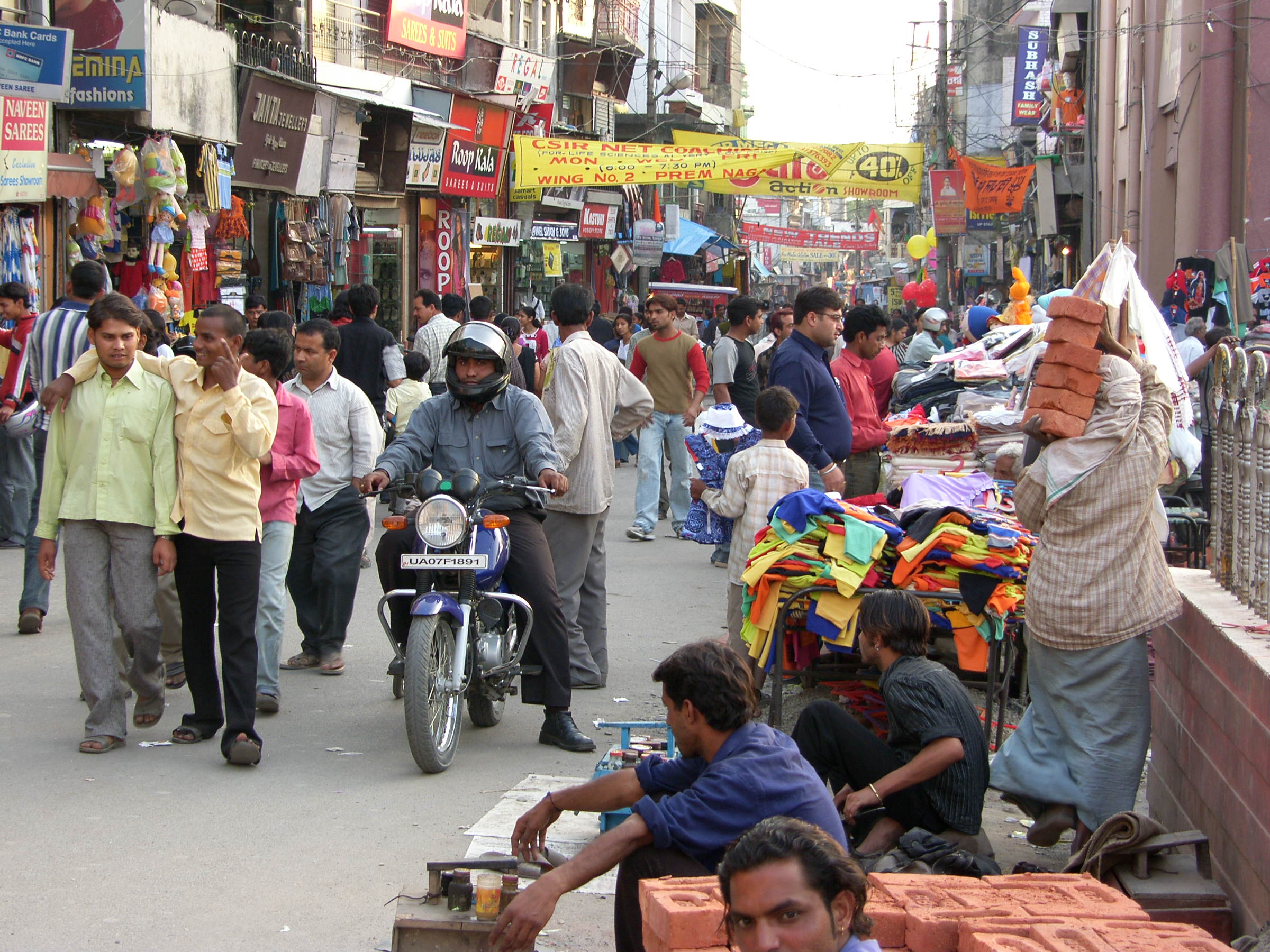
Bazaar buzz
-

Buddha statue, Dehradun
-

Dehradun at night from Mussoorie
-

5 faced Clock Tower marks the center of the city.
-

Aerial view of Indian Military Academy, Dehradun.
-

Chatwode Hall, Indian Military Academy.
-

Indian Military Academy, Dehradun.
See also
- Garhwali people
- Garhwal
- Garhwali
- Garhwal Rifles
- Bengal Engineer Group (based in Uttarakhand)
- Kumaon
- Kumaoni people
- Kumaon Regiment
- Special Frontier Force
Reference
- ^ "Town,Villages & Amenities" (in अंग्रेज़ी) (एचटीएम). देहरादून. http://dehradun.nic.in/glance.htm#TOWNS,%20VILLAGES%20AND%20AMENITIES. Retrieved 26 March 2011.
- ^ Bhushan, Ranjit. "Counter Magnets of NCR". Mydigitalfc.com. http://www.mydigitalfc.com/news/ambala-kanpur-taken-counter-magnet-towns-492. Retrieved 2010-09-01.
- ^ "देहरादून शहर मार्गदर्शिका" (एचटीएमएल). ट्रेनइन्क्वायरी.कॉम. http://www.trainenquiry.com/Hindi/StaticContent/Tourist_Info/dehradun.html. Retrieved 26 March 2011.
- ^ Natural Resource Management By B.W. Pandey (ed. By) Page 226 ISBN 8170999863 Mittal Publications,India Language English (31 Mar 2005)
- ^ The History of Sikh Gurus ISBN 8183820751 page 112 Chapter 8
- ^ ए ब्रीफ हिस्ट्री एण्ड प्रोफ़ाइल ऑफ़ देहरादून उत्तराखंड सरकार वेबसाइट।
- ^ "गौरवशाली इतिहास है देहरादून का" (एचटीएमएल). म्यार पहाड़. http://kandpalsubhash.blogspot.com/2008/05/blog-post_7899.html?showComment=1211199960000. Retrieved 26 March 2011.
- ^ "Altitude" (in अंग्रेज़ी) (एचटीएमएल). देरादून. http://210.212.78.56/dehradun/English/altitude.html. Retrieved 26 March 2011.
- ^ "Important District Indicators" (in अंग्रेज़ी) (एचटीएम). देरादून.निक.इन. http://dehradun.nic.in/glance.htm#TOWNS,%20VILLAGES%20AND%20AMENITIES. Retrieved 26 March 2011.
- ^ "देहरादून" (एक्सएमएल). उत्तराकृषिप्रभा. http://uttarakrishiprabha.com/wps/portal/!ut/p/kcxml/04_Sj9SPykssy0xPLMnMz0vM0Y_QjzKLN4j3dQLJgFjGpvqRINrNBybiCBFAKPFFiPh65Oem6gcBZSLNgSKGBs76UTmp6YnJlfrB-t76AfoFuaGhEeXejgBpzmUQ/delta/base64xml/L0lJSk03dWlDU1EhIS9JRGpBQU15QUJFUkVSRUlnLzRGR2dkWW5LSjBGUm9YZmcvN18wXzEwQw!!?WCM_PORTLET=PC_7_0_10C_WCM&WCM_GLOBAL_CONTEXT=/wps/wcm/connect/UAAP_HI/Home/Know+Uttaranchal/Garhwal+Region/%E0%A4%97%E0%A4%A2%E0%A4%B5%E0%A4%BE%E0%A4%B2+%E0%A4%95%E0%A5%8D%E0%A4%B7%E0%A5%87%E0%A4%A4%E0%A5%8D%E0%A4%B0+%E0%A4%95%E0%A5%87+%E0%A4%9C%E0%A4%A8%E0%A4%AA%E0%A4%A6/%E0%A4%A6%E0%A5%87%E0%A4%B9%E0%A4%B0%E0%A4%BE%E0%A4%A6%E0%A5%82%E0%A4%A8. Retrieved 26 March 2011.
- ^ [1]
- ^ [2]
- ^ "इनका आकर्षण है खास" (एचटीएमएल). देहरादूनएक्सकर्शन्स. http://210.212.78.56/dehradun/Hindi/excursions.html. Retrieved 26 March 2011.
- ^ "उत्तराखंड के आकर्षण" (एएसपी). अमर उजाला. http://www.amarujala.com/VasantUtsav/val.asp?mainsec=3&subsec=5. Retrieved 26 March 2011.
- ^ "इंस्ट्टीट्यूशंस" (in अंग्रेज़ी) (एचटीएम). देहरादून प्रशासन. http://dehradun.nic.in/Institution.htm. Retrieved 26 March 2011.
- ^ "National Institute for the Visually Handicapped" (in अंग्रेज़ी) (एचटीएमएल). एन.आई.वी.एच. http://www.nivh.org/. Retrieved 26 March 2011.
- ^ "Rehabilitation Council of India" (in अंग्रेज़ी) (एचटीएम). रिहैबिलिटेशन काउंसिल ऑफ़ इंडिया. http://rehabcouncil.nic.in/programmes/study_center.htm. Retrieved 26 March 2011.
- ^ "करुणा विहार" (in अंग्रेज़ी) (एचटीएम). रिहैबिलिटेशन काउंसिल ऑफ़ इंडिया. http://gashwingomes.blogspot.com/2005/10/karuna-vihar.html. Retrieved 26 March 2011.
- ^ "देहरादून" (एचटीएमएल). देहरादून. http://210.212.78.56/dehradun/Hindi/indexcity.html. Retrieved 26 March 2011.
- ^ http://www.dehradun.stpi.in
Categories:- Indian capital cities
- Districts of Uttarakhand
- Dehradun district


Wikimedia Foundation. 2010.