- Eastern Shore of Maryland
-
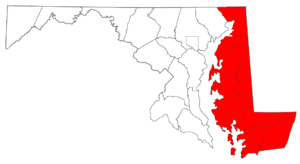
The Eastern Shore of Maryland is a territorial part of the State of Maryland, USA that lies predominately on the east side of the Chesapeake Bay and consists of nine counties. The origin of term Eastern Shore was derived to distinguish a territorial part of the State of Maryland from the Western Shore of Maryland, land west of the Chesapeake Bay. As of 2010, its population was 449,226, with just under 8 percent of Marylanders living in the region.
Contents
Geography
The Eastern Shore consists of 9 of the 23 state counties that lie within: the east-side of the major part of the center of the Chesapeake Bay; the east-side part of the center of the Susquehanna River(or the western border of Harford County); a southern portion of border (Mason-Dixon Line) of the State of Pennsylvania; the west and south of the borders of the State of Delaware; part of the East coast of the Atlantic Ocean; and the north border of the Eastern Shore of Virginia. The Eastern Shore of Maryland is part of the Delmarva Peninsula.
The counties in Maryland include: Caroline County, Cecil County, Dorchester County, Kent County, Queen Anne's County, Somerset County, Talbot County, Wicomico County, and Worcester County. On the south, the Calvert-Scarborough Line separates the Eastern Shore of Maryland from that of Virginia. A modern Worcester County highway map (PDF) shows its location. While not exactly where it was laid down in the 17th-18th century, it has moved little once everyone could agree on where Watkins Point, on the western side of the peninsula, is and where the shore of the Bay began (since the bay side peters out into marshes and wetlands).
In 1668, Philip (Calvert -ed.)obtained recognition from Virginia of Maryland's claims to what is now Somerset County and actually participated in the survey of the dividing line between the two colonies with the Surveyor General of Virginia, Edmund Scarborough. At about the same time, he negotiated treaties with Lower Eastern Shore Indian tribes who were harassing English settlers. The terms of these treaties established rules of behavior in Indian-English relations that applied to whites as well as Indians, and on the whole, kept peace in the area thereafter.[1]
The northern limit is harder to place.
Some dispute Cecil County as a true Shore county, however, because of the presence of I-95 and related development, proximity to and influence from nearby urban areas such as Philadelphia, Pennsylvania, Wilmington, Delaware, and the state of New Jersey, as well as its position straddling the Elk River - leaving half geographically west of the Shore, if the Elk River is taken as its northern edge.
Land and water both figure in the argument about whether Cecil County is part of the Eastern Shore, and so do man-made features.
Like New Castle County Delaware, Cecil County is crossed by the fall line, a geologic division where the rockier highlands of the Piedmont region becomes the coastal plain, a flat, sandy area that forms the coast. The coastal plain includes the Delmarva Peninsula and that includes the Eastern Shore of Maryland. The geology of Delmarva is an inseparable part of the Eastern Shore, which has few rocky outcrops south of Kent County, Md.
The Chesapeake and Delaware Canal crosses from Back Creek on the Elk River to Port Penn, Del. While it was a shallow canal with locks after its construction in 1829, it was deepened in the early 20th century to sea level, and physically separates the Delmarva Peninsula from the rest of the United States. Maryland, south of the canal, is usually considered the Eastern Shore by residents. (The term "Western Shore" is less common).
The north-south section of the Mason-Dixon Line forms the border between Maryland and Delaware. Like the canal, it's a manmade construct, originally marked every mile by a stone, and every five miles by a "crownstone." The line is not quite due north and south, but is as straight as survey methods of the 1760s could make it and is completely artificial.
It was surveyed as a compromise solution to a century-long wrangle between the Penn and Calvert families of England. If the Chesapeake Bay/Delaware Bay watershed was taken as the borderline, Delaware would be about half its current size.
Finally, although this has received less attention than other parts of Eastern Shore culture, commercial east-west ties between Delaware towns and Maryland towns were culturally significant in Colonial and Early American periods despite the border line (which largely cut through woods and swamps). Trade with Philadelphia was conducted by overland routes to Delaware towns like Odessa (then called Cantwell's Bridge) and Smyrna (then called Duck Creek). Agricultural products and milled grain were taken up the Delaware River by "shallop men" in small vessels called shallops. These cultural connections continue to this day.
Ocean City is a modern resort on what was once called the "seaside" or "seaboard side." It is on a long north-south sandspit that is essentially a barrier island.[2]
History
Early history
William Claiborne was granted land (part of Colony of Virginia) in 1629 and named Kent County. In 1631, he sailed north up the Chesapeake Bay from South and West-side of the Chesapeake to an area known today as Kent Island, Maryland. There he made a fortified settlement that is considered to be the first English settlement within the Province of Maryland, known today as State of Maryland. Talbot County, Maryland was formed in 1662. Cecil County, Maryland was formed in 1674. Wicomico County, Maryland was formed in 1867, as the 9th and last county.
Formation and etymology of the counties
- 1642 Kent County-In 1642, the governor and council appointed commissioners for the Isle and County of Kent. This act appears to have led to the establishment of Kent County, name after Kent County, England.
- 1661 Talbot County- named for Lady Grace Talbot, the wife of Sir Robert Talbot, an Irish statesman, and the sister of Cæcilius Calvert, 2nd Baron Baltimore.
- 1666 Somerset County-named for Mary, Lady Somerset, the wife of Sir John Somerset and daughter of Thomas Arundell, 1st Baron Arundell of Wardour.
- 1669 Dorchester County-Named for the Earl of Dorset, a family friend of the Calverts (the founding family of the Maryland colony).
- 1706 Queen Anne's County- formed from northern parts of Talbot and southern portions of Kent. Name after Queen Anne of Great Britain who reigned when the county was established.
- 1742 Worcester County-named for an Earl of Worcester.
- 1773 Caroline County- formed from parts of Dorchester and Queen Anne's Counties. The county derives its name from Lady Caroline Eden, wife of Maryland's last colonial governor of Province of Maryland, Robert Eden.
- 1674 Cecil County.
- 1867 Wicomico County.
The first county formed was Kent County, settled by William Claiborne in 1631. Cecil County was created in 1674, by proclamation of the Governor, from eastern portions of Baltimore County and northern portion of Kent County. The last county formed was Wicomico County, created from Somerset and Worcester Counties in 1867.
Later history
Ocean City was founded on July 4, 1875[3] when the Atlantic Hotel opened on Assateague Island. At the time, Assateague Island was continuous from the Delaware state line to well south of Ocean City: the Ocean City Inlet wasn't formed until a hurricane, in August 1933, cut across the south end of the town, although the inlet was cut not by waves sweeping inland, but by 4 or 5 days' worth of freshwater runoff from the coastal creeks running seaward. By 1935, government money had built jetties to make the inlet permanent, dividing Fenwick Island (north) from Assateague Island (south). Early transportation to the island was by train.
Until the 1820s, travel and commerce between the Eastern Shore and Baltimore were less important than the connections between it and Philadelphia. Water travel by sailboat and steamer linked the Eastern Shore to Baltimore more tightly beginning about 1813, when the first steamboat traveled the Bay. By the 1880s, railroad lines linked the Eastern Shore to Philadelphia and later, Norfolk, Va. by way of a railroad line straight south from Wilmington, to Dover, Delmar, Salisbury, and Cape Charles, Va. Maryland's Eastern Shore was served by branch lines running generally southwest from the main route. See Delmarva Railroad Lines. The Eastern Shore's many branchlines were built after the Civil War by local companies; eventually all were controlled by the Pennsylvania Railroad (which also bought control of the steamboat and ferry routes); then Conrail; and now Norfolk Southern.
A west-east rail route ran from a ferry terminal at Claiborne, west of St. Michaels, to Ocean City, via the Baltimore and Eastern Shore Railroad and the Wicomico and Pocomoke Railroad. Travelers could also take a ferry to Love Point on Kent Island, board a Queen Anne's Railroad train, and travel east to Lewes and Rehoboth Beach, Delaware.
Automobile transportation across the Chesapeake Bay was by ferryboat until 1952, when the first Chesapeake Bay Bridge was opened for traffic.
In the late 1950s and early 1960s developers began selling lots on Assateague Island, south of the inlet. However, a storm on March 6, 1962 destroyed houses, shacks, and roads.[4] The state and federal governments intervened before reconstruction by creating the Assateague Island National Seashore and Assateague State Park.
An Eastern Shore Baseball League operated on three different occasions between the 1922 and 1949.[5] It was a Class D minor league with teams in all three states of Delmarva.
Demographics
Although the Eastern Shore comprises more than a third of Maryland's land area, it has a population of 420,792 (2004 census estimate), about 8% of Maryland's population.
The most populous city on the Eastern Shore is Salisbury, Maryland and the most populous county is Wicomico County. The Salisbury metropolitan area is the only metropolitan statistical area and the only Combined Statistical Area is the Salisbury-Ocean Pines CSA.
Government
Though six of the nine counties have a majority of Democratic-registered voters, the shore has supported Republicans in presidential and gubernatorial elections, and sends mostly Republicans to the Maryland General Assembly[citation needed][when?]. Currently the entire Eastern Shore is in Maryland's 1st Congressional district.[6]
Nine-term Republican Congressman Wayne Gilchrest was defeated for his party's nomination in February 2008. The 2008 race for Congress was won by Frank Kratovil, the first Democrat to represent the district in Washington, DC, since 1991, narrowly defeating Republican Andy Harris by less than 3,000 votes. Harris defeated Kratovil in 2010.
Economy
Tourism
Ocean City has been a tourist destination for Baltimoreans and Marylanders from the Western Shore in general, thus rendering the flavor of Ocean City life unlike that of the rest of the Shore. The skyline, containing many tall hotels and condominiums, is in contrast to the rest of Delmarva. On the southern end of Ocean City is a recreational boardwalk spanning over thirty blocks and containing carnival rides and games, restaurants, bars, arcades, and clothing boutiques.
Other tourist destinations include the town of St. Michael's on a neck surrounded by water; the colonial former port of Oxford; Chestertown; and isolated Smith Island in the Chesapeake Bay. North of Crisfield is Janes Island State Park, which has camping and kayaking trails through marshlands.
Fishing
At the southern end of the Chesapeake coast of Maryland, the town of Crisfield is home to a fishing, crabbing, and seafood processing industry.
Agriculture
The main economic activities on the Eastern Shore are vegetable and grain farming, seafood, large-scale chicken breeding (Perdue Farms was founded in Salisbury, Maryland and is headquartered there today), and tourism. Tobacco was grown during Colonial times but no longer. The farm economy switched to grain in the second quarter of the 18th century.[7][unreliable source?]
Infrastructure
Transportation
Waterways
Various waterways provide a medium for commerce and boaters: The Atlantic Ocean; the Chesapeake Bay; the Susquehanna River; the Delaware Bay; the Delaware River; and the C & D Canal.
Roads
There are three major routes onto the Shore:
- The Chesapeake Bay Bridge spans 4.35 miles (7.00 km) of the Chesapeake Bay and at the time of construction was the longest continuous over-water steel structure.[8] A second parallel span was added in 1973 and a third has been discussed, most recently in 2006. A third span will not open, according to state officials, until about 2025. The bridges made Kent Island, site of the first English settlement on the Shore, into a bedroom community for Washington, Annapolis and Baltimore. Kent Island is part of Queen Anne's County.
- Route 13 North.
- Maryland Route 213 South.
The two major highways on the Eastern Shore are U.S. Route 13 and U.S. Route 50 which meet in Salisbury.
Airports
The Salisbury-Ocean City Wicomico Regional Airport, in Salisbury,[9] is the only commercial airport on the Delmarva Peninsula.
Airports for private planes include:
- Bay Bridge Airport in Stevensville.[10]
- Cambridge-Dorchester Airport in Cambridge.[11]
- Crisfield Municipal Airport in Crisfield.[12]
- Easton Municipal Airport, in Easton.[13]
- Ocean City Municipal Airport in Ocean City.[14]
Secession
The Eastern Shore has always been a distinctive region, and has several times attempted to split off from the state of Maryland. Proposals have been debated in the Maryland General Assembly in 1833-1835, 1852 and recently in 1998 for the Eastern Shore becoming its own state.[15] Early proposals encompassed a state of the entire Delmarva Peninsula. The proposal in 1998 by state Senators Richard F. Colburn and J. Lowell Stoltzfus did not specify the status of the nine counties of the Eastern Shore after secession.
Sports
The Delmarva Shorebirds are a minor league baseball team who play Class A baseball in the South Atlantic League at Arthur W. Perdue Stadium in Salisbury, affiliated with the Baltimore Orioles.
Cultural
Salisbury hosts the largest cycling event east of the Mississippi - the Seagull Century; the nation's second largest KCBS barbecue competition - Pork in the Park; and two major Maryland wine and craft beer festivals.
Easton hosts a three day artist event, the Waterfowl Festival every November. Duck and goose hunting from blinds is a popular activity using carved wooden duck decoys, which can also be prized works of art.[16]
Media references
The 2005 film Wedding Crashers was filmed on locations at Maryland's Eastern Shore, including the historic Inn at Perry Cabin.
Notables
- Frank "Home Run" Baker - baseball player
- Gilbert Byron - "Poet of the Chesapeake"
- William Claiborne - first English settler within Maryland
- Frederick Douglass - abolitionist
- Jimmy Foxx - baseball player
- Robert Goldsborough - delegate to the Continental Congress
- Edward Lloyd - delegate to the Continental Congress
- Bill Nicholson - baseball player
- Matthew Tilghman - delegate to the Continental Congress
- Tench Tilghman - aid-to-camp to George Washington
- Harriet Tubman - the Underground Railroad
Towns and cities
County seats:
- Denton -- Caroline County
- Elkton -- Cecil County
- Cambridge -- Dorchester County
- Chestertown -- Kent County
- Centreville -- Queen Anne's County
- Princess Anne -- Somerset County
- Easton -- Talbot County
- Salisbury -- Wicomico County
- Snow Hill -- Worcester County
See also
- Maryland's western shore
- Eastern Shore of Virginia
- Delmarva Peninsula
- Eastern Shore Baseball League
- WBOC-TV
- WMDT-TV
- Salisbury University
- University of Maryland, Eastern Shore
Notes
- ^ See this essay by Dr. Lois Green Carr and Dr. Edward C. Papenfuse.
- ^ City on the Sand, Mary Corddry. Tidewater Publishers, 1991.
- ^ Ocean City History. ococean.com. Retrieved July 1, 2008.
- ^ Assateague Island Administrative History The Becoming of the Seashore
- ^ MLB Top 100 Teams. MLB.com. Retrieved July 1, 2008.
- ^ Maryland Election Districts Map
- ^ The Encyclopedia Americana: A Library of Universal Knowledge, Encyclopedia Americana Corp., 1919, pp. 352, http://books.google.com/?id=8VwMAAAAYAAJ&pg=PA352&lpg=PA352&dq=tobacco+%22eastern+shore%22+maryland, retrieved 2008-03-02
- ^ Baltimore Sun - Chesapeake Bay Bridge Summary. baltimoresun.com. Retrieved July 1, 2008.
- ^ Wicomico County Tourism Transportation
- ^ Queen Anne's County Bay Bridge Airport
- ^ Dorchester County, Maryland Airport Division
- ^ Somerset County, Maryland Airport
- ^ Talbot County Government Airport Information
- ^ Town of Ocean City Official Ocean City Municipal Airport
- ^ Maryland Senate Bill 564. mlis.state.md.us. Retrieved July 1, 2008.
- ^ www.waterfowlfestival.org. htm.Waterfowl Festival
External links
Categories:- Regions of Maryland
- Proposed states and territories of the United States

Wikimedia Foundation. 2010.