- Douglas County, Kansas
-
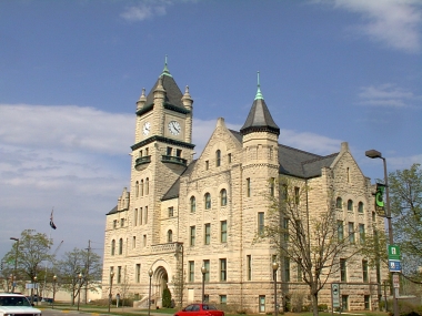
Douglas County, Kansas  Douglas County Courthouse in Lawrence
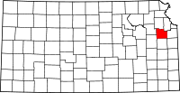
Location in the state of Kansas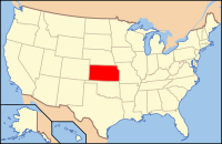
Kansas's location in the U.S.Founded August 25, 1855 Named for Stephen A. Douglas Seat Lawrence Area
- Total
- Land
- Water
474.47 sq mi (1,229 km²)
456.87 sq mi (1,183 km²)
17.60 sq mi (46 km²), 3.71%Population
- (2010)
- Density
110,826
254.7/sq mi (98/km²)Time zone Central: UTC-6/-5 Website Douglas-County.com Douglas County (county code DG) is a county located in northeast Kansas, in the Central United States. As of the 2010 census, the county population was 110,826.[1] Its county seat and most populous city is Lawrence,[2] and the entire county is included in the Lawrence, Kansas, Metropolitan Statistical Area.
Contents
History
Douglas County was opened for settlement on May 15, 1854, and was named for Stephen A. Douglas, a senator from Illinois. The county was practically at the center of the Bleeding Kansas years as leaders in Lecompton, the territorial capital, wanted Kansas to be a slave state and leaders in Lawrence wanted Kansas to be a free state. Because of this, multiple events took place, including the drafting of the Lecompton Constitution admitting Kansas as a slave state, the sacking of Lawrence, and the Battle of Black Jack.[citation needed]
Government
Douglas County is currently served by county commissioners Mike Gaughan, Nancy Thellman, and Jim Flory.[3]
Democratic state representatives of the county include Terri Lois Gregory (10th District), Barbara Ballard (44th District), and Paul Davis (46th District), Ann Mah (53rd District); Republican state representatives include Anthony Brown (38th District), Tom Sloan (45th District), and William Prescott (59th District). The three state senators representing the county, Marci Francisco (2nd District), Tom Holland (3rd District), and Anthony Hensley (19th District), are all Democrats.[4]
Geography
According to the 2000 census, the county has a total area of 474.47 square miles (1,228.9 km2), of which 456.87 square miles (1,183.3 km2) (or 96.29%) is land and 17.60 square miles (45.6 km2) (or 3.71%) is water.[5] Much of its northern boundary is defined by the Kansas River, which flows through Lawrence and provides hydropower at the Bowersock Dam.
Townships
Douglas County is divided into nine townships. The city of Lawrence is considered governmentally independent and is excluded from the census figures for the townships. In the following table, the population center is the largest city (or cities) of significant size included in that township's population total.
Township FIPS Population
centerPopulation Population
density
/km² (/sq mi)Land area
km² (sq mi)Water area
km² (sq mi)Water % Geographic coordinates Clinton 14325 531 7 (17) 80 (31) 26 (10) 24.41% 38°54′18″N 95°24′20″W / 38.905°N 95.40556°W Eudora 21700 Eudora 5,571 43 (113) 128 (49) 2 (1) 1.57% 38°55′42″N 95°6′15″W / 38.92833°N 95.10417°W Grant 27650 442 10 (27) 43 (16) 0 (0) 0.74% 39°0′8″N 95°13′19″W / 39.00222°N 95.22194°W Kanwaka 36075 1,317 12 (30) 114 (44) 8 (3) 6.69% 38°57′37″N 95°23′16″W / 38.96028°N 95.38778°W Lecompton 39175 Lecompton 1,761 20 (51) 90 (35) 2 (1) 2.45% 39°2′31″N 95°24′27″W / 39.04194°N 95.4075°W Marion 44700 836 5 (12) 185 (72) 1 (0) 0.52% 38°49′4″N 95°24′35″W / 38.81778°N 95.40972°W Palmyra 54225 Baldwin City 5,760 27 (70) 212 (82) 2 (1) 0.79% 38°47′0″N 95°10′40″W / 38.783333°N 95.17778°W Wakarusa 74400 2,237 19 (49) 119 (46) 2 (1) 1.81% 38°55′49″N 95°14′43″W / 38.93028°N 95.24528°W Willow Springs 79500 1,409 10 (26) 141 (54) 1 (0) 0.54% 38°47′23″N 95°18′17″W / 38.78972°N 95.30472°W Sources: "Census 2000 U.S. Gazetteer Files". U.S. Census Bureau, Geography Division. http://www.census.gov/geo/www/gazetteer/places2k.html. Historic Townships
 Map of Douglas County, 1889. From History of Kansas.
 2005 KDOT Map of Douglas County (map legend)
The county originally had only four townships. Lecompton comprised the area of Lecompton, Kanwaka, and Clinton townships; Washington took the place of Marion and Willow Springs townships; Wakarusa comprised both Wakarusa and Eudora townships; and Calhoun was the original name of Palmyra township. Grant township was annexed from Jefferson County in 1874.
Adjacent counties
- Jefferson County (north)
- Leavenworth County (northeast)
- Johnson County (east)
- Miami County (southeast)
- Franklin County (south)
- Osage County (southwest)
- Shawnee County (northwest)
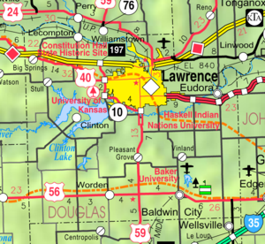
Major highways
- Interstate 70, as part of the Kansas Turnpike, runs east to west just north of Lawrence.
- U.S. Highway 59 runs north to south through the middle of the county and the middle of Lawrence.
- U.S. Highway 40 virtually follows the Oregon Trail heading west out of Lawrence.
- U.S. Highway 56 runs east to west in the southern half of the county, going through Baldwin City and skirts the Santa Fe Trail.
- K-10 runs from the I-70 Lecompton Exchange along the south and west border of Lawrence to US-59 then north until 23rd Street where it heads east out of town into Johnson County.
- Other major highways include: US-24 which is in Grant township leading from Leavenworth to Jefferson County; K-32 starts just outside of Lawrence and leads into Leavenworth County and K-33 is in extreme southeast Douglas County and leads into Franklin County.
Parks and Events
Clinton Lake, completed in 1980, offers boating, fishing and other water sports and various parks surrounding the lake provides camping and trails for mountain biking, hiking and horseback riding. The Wakarusa Music and Camping Festival was held there every June from 2004 to 2008.[citation needed]
Lone Star Lake is a small country lake to the southwest of Lawrence offers fishing, boating and camping. Just northwest of Baldwin City is Douglas State Fishing Lake which provides hunting, fishing and limited camping. Other parks around the county include Black Jack Park which includes the Ivan Boyd Prairie Preserve and Robert Hall Pearson Memorial Park, Broken Arrow Park in Lawrence and Wells Overlook Park just south of Lawrence.[citation needed]
Other events in the county include the Maple Leaf Festival in Baldwin City every third full weekend in October. Lecompton's Territorial Days take place every year in June and Lawrence has many parades throughout the year including Christmas and St. Patrick's Day.[citation needed]
Demographics
Historical populations Census Pop. %± 1860 8,637 — 1870 20,592 138.4% 1880 21,700 5.4% 1890 23,961 10.4% 1900 25,096 4.7% 1910 24,724 −1.5% 1920 23,998 −2.9% 1930 25,143 4.8% 1940 25,171 0.1% 1950 34,086 35.4% 1960 43,720 28.3% 1970 57,932 32.5% 1980 67,640 16.8% 1990 81,798 20.9% 2000 99,962 22.2% 2010 110,826 10.9% U.S. Decennial Census As of the U.S. Census in 2000,[6] there were 99,962 people, 38,486 households, and 21,167 families residing in the county. The population density was 219 people per square mile (84/km²). There were 40,250 housing units at an average density of 88 per square mile (34/km²). The racial makeup of the county was 86.09% White, 4.24% Black or African American, 2.56% Native American, 3.12% Asian, 0.06% Pacific Islander, 1.20% from other races, and 2.73% from two or more races. Hispanic or Latino of any race were 3.27% of the population.
There were 38,486 households out of which 27.40% had children under the age of 18 living with them, 43.10% were married couples living together, 8.50% had a female householder with no husband present, and 45.00% were non-families. 28.50% of all households were made up of individuals and 5.80% had someone living alone who was 65 years of age or older. The average household size was 2.37 and the average family size was 2.97.
In the county the population was spread out with 20.40% under the age of 18, 26.40% from 18 to 24, 28.30% from 25 to 44, 16.90% from 45 to 64, and 7.90% who were 65 years of age or older. The median age was 27 years. For every 100 females there were 98.70 males. For every 100 females age 18 and over, there were 97.70 males.
The median income for a household in the county was $37,547, and the median income for a family was $53,991. Males had a median income of $35,577 versus $27,225 for females. The per capita income for the county was $19,952. About 6.20% of families and 15.90% of the population were below the poverty line, including 9.00% of those under age 18 and 7.30% of those age 65 or over.
Cities and towns
Incorporated cities
Name and population (2007 estimate):
- Lawrence, 89,852 (county seat)
- Eudora, 6,077
- Baldwin City, 4,202
- Lecompton, 646
Unincorporated places
- Big Springs
- Clearfield
- Clinton
- Globe
- Grover
- Hesper
- Kanwaka
- Lake View
- Lone Star
- Midland
- Pleasant Grove
- Sibleyville
- Stull
- Vinland
- Worden
Education
 Scenic view of Rural Douglas County
Unified school districts
Douglas County is served by seven school districts.
- Lawrence USD 497 serves Lawrence and the Clinton Lake area.
- Baldwin City USD 348 serves Baldwin City and most of southern Douglas County.
- Perry-Lecompton USD 343 serves Lecompton and most of northwest Douglas County.
- Eudora USD 491 serves Eudora and the northeast part of the county.
- Santa Fe Trail USD 434 covers the southwest part of the county.
- Wellsville USD 289 covers extreme southeast Douglas County.
- Shawnee Heights USD 450 services the extreme western part of the county including Big Springs.
Universities and Colleges
The University of Kansas's main campus is located in Lawrence as is Haskell Indian Nations University. Baker University, the state's oldest university, is located in Baldwin City.
Notable people
- Isaac F. Hughes, Douglas County commissioner and City Council member in both Lawrence, Kansas, and Los Angeles, California.
See also
- National Register of Historic Places listings in Douglas County, Kansas
- Kansas River - Natural crossing point for westward wagon trains on the Oregon Trail
- California Road - Cutoff on the Oregon Trail to Lawrence, Kansas from Westport
- Santa Fe Trail Swales - Visible near Black Jack Park
- Geographic Information System Viewers
Information on this and other counties in Kansas
- List of counties in Kansas
- National Register of Historic Places listings in Kansas
- Kansas locations by per capita income
Other information for Kansas
- List of cities in Kansas
- List of unified school districts in Kansas
- List of colleges and universities in Kansas
References
- ^ "2010 County Population and Housing Occupancy Status". U.S. Census Bureau. http://factfinder2.census.gov/faces/tableservices/jsf/pages/productview.xhtml?pid=DEC_10_PL_GCTPL2.ST05&prodType=table. Retrieved March 31, 2011.
- ^ "Find a County". National Association of Counties. http://www.naco.org/Counties/Pages/FindACounty.aspx. Retrieved 2011-06-07.
- ^ Douglas County - Board of Commissioners
- ^ Douglas County - State Officials
- ^ "Census 2000 U.S. Gazetteer Files: Counties". United States Census. http://www.census.gov/tiger/tms/gazetteer/county2k.txt. Retrieved 2011-02-13.
- ^ "American FactFinder". United States Census Bureau. http://factfinder.census.gov. Retrieved 2008-01-31.
Further reading
- County
- Armitage, Katie H., “‘Seeking a Home Where He Himself Is Free’: African Americans Build a Community in Douglas County, Kansas,” Kansas History, 31 (Autumn 2008), 154–75
- State
- History of the State of Kansas; William G. Cutler; A.T. Andreas Publisher; 1883. (Online HTML eBook)
- Kansas : A Cyclopedia of State History, Embracing Events, Institutions, Industries, Counties, Cities, Towns, Prominent Persons, Etc; 3 Volumes; Frank W. Blackmar; Standard Publishing Co; 944 / 955 / 824 pages; 1912. (Volume1 - Download 54MB PDF eBook), (Volume2 - Download 53MB PDF eBook), (Volume3 - Download 33MB PDF eBook)
External links
- Official sites
- Additional information
- Maps
- 2010 Douglas County Map, KDOT
- 2011 Kansas Highway Map, KDOT
- 2011 Kansas Railroad Map, KDOT
- 2005 Kansas School District Boundary Map, KSDE

Shawnee County Jefferson County Leavenworth County 
Johnson County  Douglas County, Kansas

Osage County Franklin County Miami County Municipalities and communities of Douglas County, Kansas Cities Baldwin City | Eudora | Lawrence | Lecompton

Townships Unincorporated
communitiesBig Springs | Clearfield | Clinton | Globe | Grover | Hesper | Kanwaka | Lake View | Lone Star | Midland | Pleasant Grove | Sibleyville | Stull | Vinland | Worden
Ghost towns Categories:- Kansas counties
- Douglas County, Kansas
- 1855 establishments in the United States
- Santa Fe Trail
- Oregon Trail
- California Trail


Wikimedia Foundation. 2010.